Archipelago of San Andrés, Providencia, and Santa Catalina (Colombia)
The Archipelago of San Andres, Providencia, and Santa Catalina is located in the western sector of the Caribbean Sea and belongs to the Republic of Colombia. The entire collection of 10 or so small coral atolls and a marine area was declared the Seaflower Biosphere Reserve by UNESCO.
]")


 by Rodrigo Bernal (CC BY-NC-ND 2.0) https://www.flickr.com/photos/chibcha/19659739512")
Archipelago of San Andrés, Providencia, and Santa Catalina
The Archipelago of San Andres, Providencia, and Santa Catalina (ASAPSC) is located in the western sector of the Caribbean Sea and belongs to the Republic of Colombia.
The collection of ten or so small coral atolls that form the San Andres Archipelago is known as the West Indies Department of Colombia. The total population is approximately 5,000.
The archipelago consists of San Andrés and Providencia islands and several minor keys 710 km (440 miles) northwest of Cartagena, Colombia, and 180 km (110 miles) off the coast of Nicaragua. Three of the keys are also claimed by the United States.
San Andrés is the archipelago's largest island, and its capital is also called San Andrés. The other large islands are Providencia and Santa Catalina Islands, northeast of San Andrés; their capital is Santa Isabel.
The islands were settled in 1629 by English Puritans and later by planters, woodcutters and enslaved Black people from Jamaica. The population today remains English-speaking and Protestant.
The islands were awarded to Spain in 1786 and became part of Colombia in 1822. However, a protracted dispute with Nicaragua over the islands ensued. Finally, in 2012, the International Court of Justice (ICJ) ruled that Colombia had sovereignty over the islands.
The United States maintains claims over Serranilla Bank and Bajo Nuevo Bank, considering them both to be unincorporated territories of the United States.
The primary industry is tourism. San Andrés, the capital, produces coconuts, copra, and oranges; Providencia relies on subsistence agriculture.
Biosphere Reserve
In 2000, the entire archipelago was declared a UNESCO Biosphere Reserve. Seaflower Biosphere Reserve includes the islands and a marine area of 300,000 sq km (120,000 sq mi). The purpose of the Biosphere Reserve is to ensure that the ecosystem, which is rich in biodiversity, is well preserved and conserved.
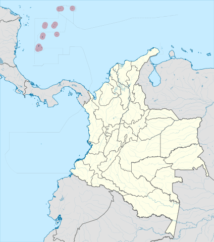
Map depicting the location of the Archipelago of San Andres, Providencia, and Santa Catalina in the Caribbean Sea
Main Islands
San Andrés Island
San Andrés is a coral island in the Caribbean Sea approximately 750 km (470 mi) northwest of the coast of Colombia. The island has an area of 26 sq km (10 sq mi).
Politically part of Colombia and historically tied to the United Kingdom, San Andrés, along with the nearby islands of Providencia and Santa Catalina, make up the department of San Andrés, Providencia and Santa Catalina.
The department's capital is located on the island's northern end. The department's main urban center is named San Andrés, nicknamed El Centro. The official languages are Spanish, English and San Andrés–Providencia Creole.
San Andrés has a reasonably flat topography, with the highest point on the island reported at 55 m (180 ft) above sea level. San Andrés is crossed from south to north by a small mountain range whose highest peak is Cerro La Loma, also known as El Cliff.
San Andrés' soils indicate that their formation is due to the eruption of a volcano that threw rocks older than the seafloor to the surface, creating the islands. Despite this, there is fertile soil, primarily red clay. It is easy to find small deposits of quartz on the island, especially in the neighborhood of La Loma Cove.
Aside from the main settlements, the island is almost entirely covered in grass, trees, other vegetation, and sand along the coastline rather than rocks. The central area is marked by hills (Flowers, Orange, Shingle, and Lion's Hill). The island has only small, ephemeral streams draining the land area but no major rivers.
On the island's southwest coast are some features, namely (from north to south) Bobby Rock, Boobie Rock, Fisher Rock, and Tyler Rock. In addition, a feature named Rock Point is located on the southeastern coast.
Suky Bay lies in the central-western part of the island near the Cove Sea Side. The island's northern region has a beach, while the western area has no beaches.
The island is surrounded on its northwest side by a small coral reef and several keys home to varied fauna and flora.
Johnny Cay is a small coral islet located 1.5 km (0.93 mi) north of San Andrés Town. It features white sand beaches surrounded by coconut plantations.
Haynes Cay is where cruise ships dock. There are several large coral farms here with a variety of species. This area is also popular for water sports activities like snorkeling and diving.
The island experiences a tropical monsoon climate that borders on a tropical wet and dry climate. Average temperatures range from 24 - 30 °C (75 - 86 °F) in two periods dominated by dry and rainy spells. The rainy season is from May to January, with high humidity.
Providencia and Santa Catalina Islands
Isla de Providencia, historically called Old Providence and generally now known as Providencia, is a mountainous Caribbean island lying midway between Costa Rica and Jamaica. Providencia's maximum elevation is 360 m (1,180 ft) above sea level.
To the northwest, the smaller Santa Catalina Island is connected by a 100 m (330 ft) footbridge to its larger sister Providencia Island. Low Cay, a tiny islet, lies more than 10 km (6 mi) further north.
Providencia Island covers 17 sq km (6.5 sq mi), while the two islands cover an area of 22 sq km (8.5 sq mi) and form the municipality of Santa Isabel. The reef off Santa Catalina and Providencia covers an area of approximately 255 sq km (98 sq mi) and is over 32 km (20 mi) long.
The island was the site of an English Puritan colony established in 1629 by the Providence Island Company and was briefly taken by Spain in 1641. The pirate Henry Morgan used Providencia as a base for raiding the Spanish empire.
Many parts of the island are named after Morgan. Forts and cannons dating back hundreds of years can be found scattered all over Santa Catalina Island.
The mountainous center of Providencia Island rises to three peaks of about the same elevation: roughly 363 m (1,190 ft). The island consists of sedimentary rocks laid down on a former volcano.
The chief settlement is Santa Isabel Village, in the north, near Santa Catalina Island. Other villages are Lazy Hill on the west coast and Bottom House on the southeast.
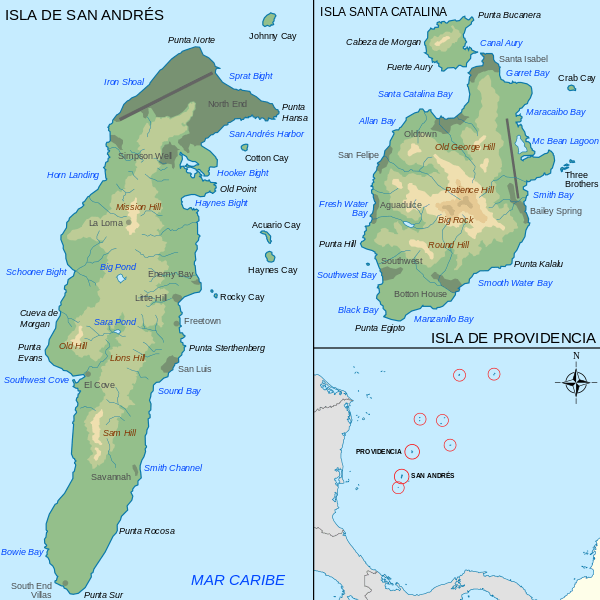
Maps depicting San Andrés, Santa Catalina, and Providencia islands