Azuero Peninsula: Gulf of Panama and the Pearl Islands (Central America)
The Azuero Peninsula is in southern Panama, surrounded by the Pacific Ocean and the Gulf of Panama. Panama City, the Panamanian capital, is the main urban center on the gulf shore. The Pearl Islands are an archipelago in the Gulf of Panama.


Azuero Peninsula
The Azuero Peninsula is located in southern Panama. It is surrounded by the Pacific Ocean in the south, the Pacific and Gulf of Montijo to the west, and the Gulf of Panama to the east. It measures 100 km (60 mi) from east to west and 90 km (55 mi) from north to south.
The peninsula is effectively divided into two regions, the Western Azuero and the Eastern Azuero, as no good roads join the two peninsula regions past the Pan-American Highway.
The Azuero region was one of the first parts of Panama to be settled more than 10,000 years ago, and the area in the north of the peninsula was cultivated thousands of years before the arrival of the Spaniards.
The Azuero Peninsula is divided into three provinces: Herrera, Los Santos (entirely on the peninsula) and Veraguas, which extends into it on the peninsula's west side. However, most of the people live within the east coastal region.
The southern tip is sparsely populated, and the western area (the Veraguas area) has recently opened up to development. The largest towns are Chitré (the capital of Herrera) and Las Tablas, which are linked by road to the Pan-American Highway.
The region's long history of cultivation and grazing has harmed the environment, resulting in what is sometimes called the "Sarigua desert" in the northeastern area of the peninsula, even though it is not technically a desert.
Along the coast are areas of mangroves, and just inland is a dry coastal forest called Albina. The Azuero is one of the most heavily deforested parts of Panamá, although sustainable land management systems such as SilvoPastoral grazing systems are emerging.
In the extreme south, Cerro Hoya is a national park and home to most of the remaining jungle habitat in the Azuero region. In addition, Isla Canas, a coastal island connected via a sandbar to the peninsula, is used by many sea turtles to lay their eggs yearly.
Relief map of the Azuero Peninsula
Gulf of Panama
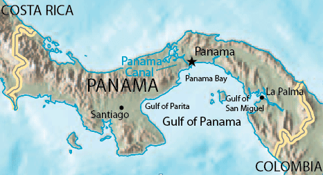
The Gulf of Panama is a gulf in the Pacific Ocean near the southern coast of Panama. It has a maximum width of 250 km (160 mi), a maximum depth of 220 m (720 ft) and a size of 2,400 sq km (930 sq mi). The Panama Canal connects the Gulf of Panama with the Caribbean Sea and the Pacific Ocean.
The Panamanian capital, Panama City, is the main urban center on the Gulf shore. The Gulf of Panama also contains minor gulfs: Panama Bay to the north, the Gulf of Parita to the west and the Gulf of San Miguel to the east.
The Gulf of Panama has a few islands, and on the coast, there are a few important ports, like Panama City, La Palma and Chitrè.
Pearl Islands
The Pearl Islands (Archipiélago de las Perlas) is an archipelago in the Gulf of Panama, about 80 km (50 mi) southeast of Panama City. The archipelago consists of 183 islands, of which 39 are sizable. The locals call the islands Islas de las Perlas, a name that dates back to Spanish colonial times.
The Spanish Conquistadors discovered the islands in 1503 and named the Islands due to the significant number of pearls on them. Today, the islands are visited by fishermen in search of the marine life that abounds in the local waters.
The most famous island is Isla Contadora, known for its resorts. Isla Contadora was said to be used by the Spanish conquistadors as a stop for taking inventory of booty before returning to Spain.
Other important islands include the mountainous Isla del Rey, where the principal town, San Miguel, is located. It is the largest island, at 234 sq km (90 sq mi), and it has several towns, most notably San Miguel. It is easily more prominent than the other Pearl Islands combined and is the second largest island in Panama, after Coiba. Other important islands are San José, Pedro González, and Saboga.
Other islands include:
- Bolano Island
- Buena Vista Island
- Cana Island
- Casaya Island
- Chapera Island
- Chitre Island
- Cocos Island
- Espiritu Santo Island
- Galera Island
- Gallo Island
- Gilbraleon Island
- Lampon Island
- Marin Island
- Mina Island
- Mogo Mogo o Pajaro
- Pacheca Island
- Pachequille Island
- Pedro Gonzalez Island
- Puerco Island
- San Jose Island
- Senora Island
- Vivenda Island
- Viveros Island