Cordillera Negra: Peruvian Andes (Peru)
The Cordillera Negra is part of the Cordillera Occidental, one of three ranges in the Peruvian Andes system of west-central Peru. The range has rocky peaks with very little winter snowfall. The gullies of the range are gloomy, dark, and mostly dry.
 https://www.flickr.com/photos/inyucho/7867582856/")
 via Wikimedia Commons")
 via Wikimedia Commons")
Cordillera Negra
The Cordillera Negra is part of the Cordillera Occidental, one of three ranges in the Peruvian Andes system of west-central Peru. It lies about 965 km (600 mi) northeast of Lima and is almost entirely located within the Ancash Region.
It extends for about 180 km (110 mi) northwest to southeast from the mouth of the Santa River parallel to the Pacific coast. Its ridge is about 60 km from the coastline and rises to 4,430 m (14,764 ft).
The upper Santa River Valley, the Callejón de Huaylas, separates the Cordillera Negra from the Cordillera Blanca, a range of permanently snow-capped mountains to the east.
The Cordillera Negra has rocky peaks with very little winter snowfall. The gullies of the range are gloomy and dark. Most of them are dry, or their flow is scarce.
In the south, the Cordillera Negra is bordered by the Patiwillka River. In the central part of the range, near Huaráz, the Casma River breaks through the ridge of the range.
The highest mountain in the range is Coñocranra at 5,181 m (16,998 ft) asl. Other peaks at or above 5,000 m (16,400 ft) asl are listed below:
- Kankawa, 5,102 m (16,739 ft)
- Qarwaqucha, 5,070 m (16,634 ft)
- Rumi Cruz, 5,020 m (16,470 ft)
- Cerro Rico, 5,006 m (16,424 ft)
- Akapa Ranin, 5,000 m (16,404 ft)
- Kushuru, 5,000 m (16,404 ft)
- Q'iruqucha, 5,000 m (16,404 ft)
More than 50 additional peaks rise to 4,000 m (13,000 ft) asl or above.
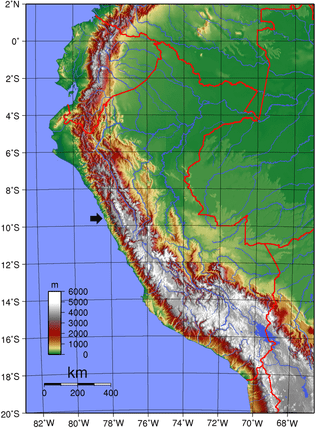
Terrain map: arrow indicates the location of the Cordillera Negra
Today, the Cordillera Negra is sparsely inhabited by a mainly indigenous population growing wheat, maize and oats at a well above 4,000 m (13,000 ft). The range is rich in mineral resources like gold, silver and copper.
Guitarrero Cave
In the 1960s, the Guitarrero Cave was discovered on the northern edges of the Cordillera Negra, a cave containing bones of mastodon and llama, suggesting human occupation as far back as 10,950 to 10,230 BC.
Textiles, wood and leather tools, and basketry have been preserved. Some evidence of early domesticated beans is Phaseolus, chili, corn, and other cultivated plant varieties.
Textiles in the cave date back over ten thousand years – the earliest found in South America. The cave held utilitarian containers made by twisting, looping and knotting plant fibers. The people of the Guitarrero Cave are possible ancestors of the Chavín culture.