Cordillera Occidental: Mountain Range (Bolivia)
The Cordillera Occidental, or Western Cordillera, of Bolivia is a mountain range in extreme western Bolivia, forming a natural border with Chile. The range is part of the Andes Mountains system, which, in turn, is part of the American Cordillera.

Cordillera Occidental
The Cordillera Occidental, or Western Cordillera, of Bolivia is a mountain range in extreme western Bolivia, forming a natural border with Chile.
Beginning in the north at Juqhuri on the border with Peru and ending in the south at the Licancabur volcano, the extent of the Cordillera Occidental is approximately 700 km (435 mi).
The range is part of the Andes Mountains system, which, in turn, is part of the American Cordillera. It is the westernmost of Bolivia's two main ranges and is separated from the Cordillera Oriental to the east by the high plateaus of the Altiplano.
Constructed on thick crust, the Cordillera Occidental contains numerous active volcanoes and is crowned by the country's highest peak, Nevada Sajama. It also hosts the spectacular Salar de Uyuni at an elevation of 3,656 m (11,995 ft).
The Cordillera Occidental consists of three sections:
-
North: contains the highest peaks in Bolivia, the tallest of which is the volcano Nevada Sajama at 6,542 m (21,463 ft). Sajama is perennially covered in snow. It contains the volcanoes Pomerape and Parinacota (called Payachata collectively), the latter being a dormant volcano with a cone of snow.
-
Central: situated between Uyuni and Coipasa. Its most prominent summit is the Ollagüe (Ullawi) volcano on the border with Chile.
-
South: characterized by volcanic activity, sandstorms and fog. The Licancabur stratovolcano is located here, which is 5,920 m (19,422 ft) in elevation, but only two-thirds of the northeastern slope of the volcano belongs to Bolivia. The lakes Laguna Colorada and Laguna Verde can be found on Licancabur, so named because of their respective colors.
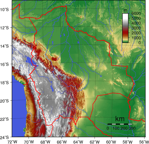
Topographic map of Bolivia depicting (east to west) the Amazon Basin in green, Sub-Andean Zone in red, Cordillera Oriental in white, Altiplano in gray, and Cordillera Occidental in white