Cordillera Oriental / Cordillera Real: Mountain Range (Bolivia)
The Cordillera Oriental of Bolivia is part of the Andes Mountains system. It is the easternmost of Bolivia's two main ranges and separates the lowlands of the Amazon River basin to the east from the Altiplano to the west. The northern section of the range is known as the Cordillera Real.
 - by Tasmita Gz, CC BY-SA 3.0 via Wikimedia Commons")
Cordillera Oriental
The Cordillera Oriental is part of the Bolivian Andes, within the greater Andes mountain system, which in turn is part of the American Cordillera that forms the western "backbone" of North America, Central America and South America.
The Cordillera Oriental extends for about 1,200 km (750 mi), roughly bisecting the country of Bolivia from north to south. It is the easternmost of the country's two main ranges and separates the lowlands of the Amazon Basin to the east from the high plateaus of the Altiplano to the west.
Also to its west, along the border with Chile, lies the Cordillera Occidental. Between the two ranges, the Altiplano extends through the country's entire length, from Peru to Argentina.
The Cordillera Oriental is composed of six lesser ranges, some of which connect laterally with the Cordillera Occidental in the west:
- Cordillera de La Paz
- Cordillera Tres Cruces
- Cordillera Azanaques
- Cordillera Frailes
- Cordillera Chichas
- Cordillera Lípez
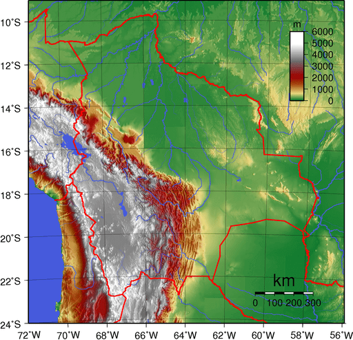
Topographic map of Bolivia depicting (east to west) the Amazon Basin in green, the Sub-Andean Zone in red, the Cordillera Oriental in white, the Altiplano in gray, and the Cordillera Occidental in white
Cordillera Real
The northern section of the Cordillera Oriental, situated southeast of Lake Titicaca and east of the Bolivian capital of La Paz, is known as the Cordillera Real ("Royal Range"), which includes a spectacular line of snowcapped peaks.
Densely glaciated, the Cordillera Real runs for approximately 125 km and is about 20 km in width. Aymara and Quechua indigenous villages are located in the foothills. To the north of the Cordillera Real is the Apolobamba range.
There are numerous notable peaks in the Cordillera Oriental / Cordillera Real. Those over 5,800 m (19,000 ft) in elevation above sea level (asl) include:
- Illimani: 6,438 m (21,122 ft) asl
- Janq'u Uma: 6,427 m (21,086 ft) asl
- Illampu: 6,368 m (20,892 ft) asl
- Layqa Qullu: 6,166 m (20,230 ft) asl
- Ch'iyar Juqhu: 6,127 m (20,102 ft) asl
- Wayna Potosí: 6,088 m (19,974 ft) asl
- Chachakumani: 6,074 m (19,928 ft) asl
- Pico del Norte: 6,070 m (19,915 ft) asl
- Khunu Tawa: 5,981 m (19,623 ft) asl
- Mamaniri: 5,970 m (19,587 ft) asl
- Qullu Wich'inka: 5,970 m (19,587 ft) asl
- Wayna Illampu: 5,950 m (19,521 ft) asl
- Qutaña (Pico Schulze): 5,933 m (19,465 ft) asl
- Janq'u Piti: 5,918 m (19,416 ft) asl
- Qillwani: 5,828 m (19,121 ft) asl
- Pirámide: 5,906 m (19,377 ft) asl
- Kimsa Qullu: 5,893 m (19,334 ft) asl
- Qalsata: 5,874 m (19,272 ft) asl
- Mururata: 5,871 m (19,262 ft) asl
- Laram Quta: 5,840 m (19,160 ft) asl
- Q'asiri: 5,828 m (19,121 ft) asl