Gulf of Darién: Gulf of Urabá (Colombia, Panama)
The Gulf of Darién is the southernmost extension of the Caribbean Sea, situated off the northwestern coast of Colombia and the southeastern coast of Panama. The Gulf of Urabá, a long, wide inlet located on the coast of Colombia, is the southernmost portion of the Gulf of Darién.

Gulf of Darién
The Gulf of Darién (Golfo de Darién) is the southernmost extension of the Caribbean Sea, situated off the northwestern coast of Colombia and the southeastern coast of Panama.
Triangular in shape, the Gulf is about 350 km (220 mi) long and 150 km (93 mi) wide at its widest point. It has a surface area of about 13,000 sq km (5,000 sq mi). The Gulf is shallow, with an average depth of about 50 m (164 ft). The deepest point in the Gulf is about 200 m (660 ft).
The Isthmus of Panama bounds the Gulf of Darién to the west, the Serranía del Darién mountain range to the north in the area known as the Darién Gap, and the Colombian Chocó region to the east. It includes a shallow, mangrove-lined arm in its extreme southernmost section, known as the Gulf of Urabá.
The Gulf of Darién is a tropical estuary with a warm climate and high rainfall. The average temperature in the Gulf is about 27 °C) (81 °F). The Gulf receives an average of about 3,000 mm (118 in) of yearly rainfall.
The Gulf is home to a variety of plant and animal life. The mangrove forests that line the coast of the Gulf are home to various birds, fish, and other animals. The Gulf's waters Gulfalso home to various marine life, including sharks, rays, and turtles.
The Gulf of Darién is a vital economic resource for Panama and Colombia. It is a major shipping route for goods imported and exported from the two countries. The Gulf is also home to several fishing and aquaculture industries.
Gulf of Urabá
The Gulf of Urabá is a gulf on the northern coast of Colombia. It is a long, wide inlet located on the coast of Colombia, close to the continent's connection to the Isthmus of Panama. It is the southernmost portion of the Gulf of Darién.
The Darién Gap, a part of the Darién National Park, is located on the western side of the Gulf of Urabá. The town of Turbo, Colombia, lies on the mid-eastern side, naturally sheltered by the Turbo Bay part of the Gulf. The Atrato River flows into the Gulf of Urabá.
The Gulf of Urabá is about 130 km (81 mi) long and 50 km (31 mi) wide at its widest point. It has a surface area of about 5,000 sq km (1,930 sq mi). The Gulf's waters are shallow, with an average depth of about 15 m (49 ft). The deepest point in the Gulf is about 60 m (200 ft).
The Gulf of Urabá is a tropical estuary with a warm climate and high rainfall. It is home to a variety of plant and animal life. The mangrove forests that line the coast are home to various birds, fish, and other animals. The Gulf's waters are home to various marine life, including sharks, rays, and turtles.
The Gulf of Urabá is a popular tourist destination known for its beautiful beaches, clear waters, and abundant wildlife. The town of Turbo is a popular tourist destination, home to several hotels, restaurants, and bars.
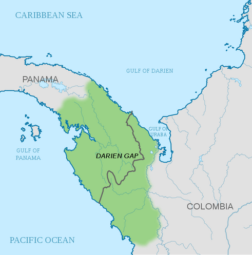
Map depicting the location of the Gulf of Darién and the Gulf of Urabá