Roatán and the Bay Islands: Jewels of the Gulf of Honduras
Nestled within the captivating Gulf of Honduras, a wide inlet of the Caribbean Sea, lies a tropical paradise – the Bay Islands. Among these islands, Roatán stands out as a jewel, renowned for its breathtaking beauty and rich natural heritage. This region is a treasure trove of natural wonders.

]")
 https://www.flickr.com/photos/funlovers/2720800584")

")

Roatán and the Bay Islands: Jewels of the Gulf of Honduras
Nestled within the captivating Gulf of Honduras, a wide inlet of the Caribbean Sea, lies a tropical paradise – the Bay Islands. Among these islands, Roatán stands out as a jewel, renowned for its breathtaking beauty and rich natural heritage. This region, indenting the coasts of Honduras, Guatemala, and Belize, is a treasure trove of natural wonders, boasting a unique ecosystem with a diverse array of coastal marine waters, including estuaries, barrier beaches, lagoons, salt marshes, mangrove forests, seagrass beds, keys, and barrier reefs. The gulf is marked by complex dynamics of coastal and open waters and ocean currents, contributing to its exceptional biodiversity.
Roatán and the Bay Islands offer a unique and captivating experience for nature enthusiasts, divers, and eco-tourists alike. These islands are a true paradise to explore with their diverse ecosystems, rich marine life, and breathtaking landscapes. From the ancient coral reefs of Roatán to the pristine islands of the Cayos Cochinos, the Gulf of Honduras and its surrounding waters promise unforgettable adventures and a deep appreciation for the natural wonders of Central America.
The Gulf of Honduras: A Diverse Ecosystem
Barrier Reefs and Coral Cays
The Gulf of Honduras is lined by the Pelican Cays of Belize to the north, part of the Belize Barrier Reef, which forms the southern portion of the 900 km long Mesoamerican Barrier Reef System. This incredible reef system is home to a stunning array of marine life, including colorful fish, coral formations, and other fascinating creatures.
River Systems and Watersheds
The gulf receives the runoff from the watersheds of 12 rivers, including the Moho, Sarstún, Río Dulce, Motagua, and Ulúa. These rivers carry vital nutrients and sediments, contributing to the health and productivity of the gulf's ecosystems. The interplay between freshwater and saltwater creates unique habitats for diverse species.
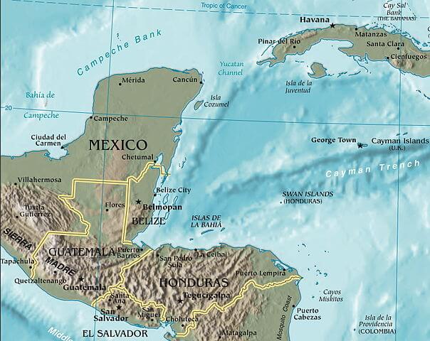
Area map depicting the location of the Gulf of Honduras.
Roatán: The Jewel of the Bay Islands
Geography and Topography
The Island of Roatán, part of the Bay Islands, rests on an exposed ancient coral reef, rising to about 270 m (890 ft) above sea level. Its mountainous backbone, composed of hilltops running west to east across the island, creates a picturesque landscape. Offshore reefs offer unparalleled opportunities for diving and exploring the vibrant marine life.
Settlements and Tourism
The most populous town on the island is Roatán (known locally as Coxen Hole), the capital of the Roatán municipality, located in the southwest. Other settlements include Gravel Bay, Flowers Bay, Pensacola, Sandy Bay, West End, West Bay, Mount Pleasant, French Harbour, Parrot Tree, Jonesville, Oakridge, and Punta Gorda.
Located near the Mesoamerican Barrier Reef, Roatán has become an important cruise ship, scuba diving, and eco-tourism destination in Honduras. It attracts visitors from around the world who want to experience its natural beauty and rich cultural heritage.
The Bay Islands: A Tropical Paradise
Island Groups
The Bay Islands comprise three separate island groups:
1. Swan Islands (Islas Santanilla or Islas del Cisne): A chain of three islands with a land area of 3.1 sq km (1.2 sq mi), initially named Islas de las Pozas by Christopher Columbus in 1502. These islands are uninhabited except for a small Honduran naval garrison on Great Swan Island.
2. Islas de la Bahía (Bay Islands): This group includes the main islands of Roatán, Guanaja, and Útila, as well as numerous satellite islands. Guanaja is the second-largest and is even more mountainous than Roatán, while Útila is characterized by low mangrove swamps and a few small, low hills on its eastern end. Barbareta, Morat, and the Hog Islands are also part of this group.
3. Cayos Cochinos: This is a group of islands located in the southern region. It comprises two small islands, Cayo Menor and Cayo Grande, and 13 smaller coral cays. These islands are a part of the Cayos Cochinos Marine Park, a Marine Protected Area. The park is established as a crucial area of the Mesoamerican Barrier Reef System and is managed by the Honduran Coral Reef Foundation.
History and Economy
The main islands were first sighted by Christopher Columbus in 1502 and were settled in 1642 by English buccaneers. Between 1650 and 1850, Spain, Honduras, and England intermittently contested the ownership of the islands. Finally, the islands were annexed to Great Britain in 1852 but were ceded to Honduras in 1859.
The economy of the Bay Islands has long relied almost entirely on the ocean, with fishing being the mainstay—a fleet of approximately 400 commercial boats primarily fishes for shrimp, lobster, and conch. Brief forays into the banana and pineapple exportation business in the late 19th century were also part of the islands' economic history.
Conclusion
The Gulf of Honduras and its Bay Islands offer a unique and captivating experience for nature enthusiasts, divers, and eco-tourists alike. With its diverse ecosystems, rich marine life, and breathtaking landscapes, this region is a paradise to explore. From the ancient coral reefs of Roatán to the pristine islands of the Cayos Cochinos, the Gulf of Honduras and its surrounding waters promise unforgettable adventures and a deep appreciation for the natural wonders of Central America.
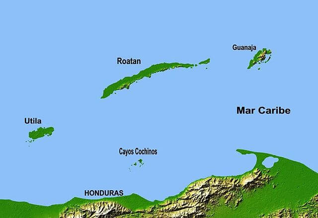
Map depicting the Bay Islands of Honduras.