The Middle America Trench and Its Acapulco-Guatemala Divisions
The Middle America Trench is a major subduction zone, an oceanic trench in the eastern Pacific Ocean off the coast of Mexico and Central America. It can be divided into a northern section called the Acapulco Trench and a southern section called the Guatemala Trench.

The Middle America Trench and Its Acapulco-Guatemala Divisions
Exploring the Oceanic Boundary that Shapes the Eastern Pacific
The Middle America Trench: Overview of a Subduction Zone
The Middle America Trench, alternatively known as the Central America Trench or Mid-American Trench, stands as a prominent oceanic trench in the eastern Pacific Ocean, defining the coastal boundaries of Mexico and Central America. This trench, a primary subduction zone, plays a pivotal role in the intricate interplay of tectonic plates, creating a geological marvel beneath the ocean's surface.
Geographical Extent
Stretching from central Mexico to Costa Rica, the Middle America Trench covers an impressive distance of approximately 2,750 kilometers (1,700 miles). Its vast expanse encompasses a total area of 96,000 square kilometers (37,000 square miles), making it one of the most significant trenches globally.
In the Depths: Submersible Landscape
At its deepest point, the trench reaches a staggering depth of 6,689 meters (21,880 feet), ranking as the 18th-deepest trench on the planet. This profound chasm is a dynamic convergence zone where the Rivera Plate, Cocos Plate, and Nazca Plate meet the North American Plate and Caribbean Plate.
Tectonic Interplay and Seismic Signature
The Middle America Trench serves as the boundary where tectonic forces come into play. The Rivera Plate, a microplate, engages with the Cocos Plate and Nazca Plate on one side, while the North American Plate and Caribbean Plate make their presence felt on the other. This intense interaction results in numerous large earthquakes, creating a seismic signature that marks the region.
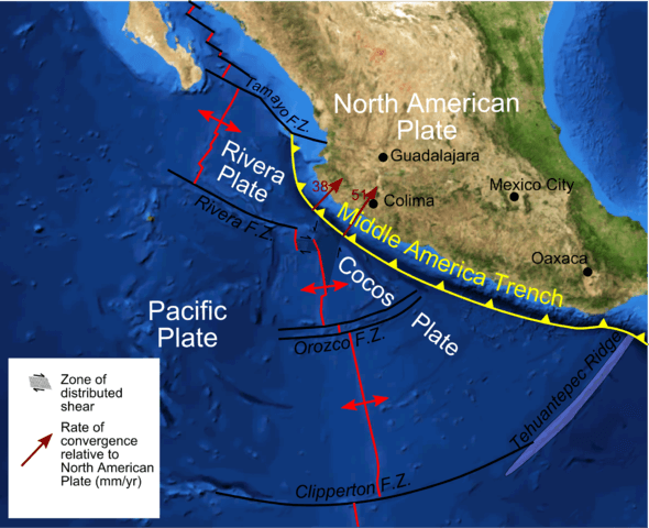
Map depicting the tectonic setting of the Middle American Trench off western Mexico.
Acapulco Trench and Guatemala Trench: Northern and Southern Divisions
The Middle America Trench can be dissected into two distinct sections, both in the seaward and landward directions, giving rise to the Acapulco Trench in the north and the Guatemala Trench in the south.
Seaward Divisions
-
Acapulco Trench: Running from Jalisco to the Tehuantepec Ridge, the northern section of the trench on the seaward side mimics the curvature of the Mexican coast. Bordered by the Tamayo Transform Fault, which is part of the East Pacific Rise, it encapsulates the dynamic subaquatic landscape off the Mexican shores.
-
Guatemala Trench: On the seaward side, the southern section takes a near-linear course from the Tehuantepec Ridge to the Cocos Ridge off the coast of Costa Rica. This trench segment unfolds as a submerged feature, influencing the ocean floor's topography.
Landward Divisions
The division on the landward side is demarcated along the Polochic-Motagua fault system, serving as the boundary between the North American and Caribbean plates. Interestingly, the division on the landward side is about 400 kilometers (250 miles) east of its seaward counterpart.
Volcanic Associations in the Southern Section
The southern section of the trench, particularly the Guatemala Trench, is closely linked to active volcanism on land. This correlation underscores the interconnectedness of submarine and terrestrial geological processes, forming a dynamic tapestry that shapes the region's geological landscape.
In conclusion, the Middle America Trench and its Acapulco-Guatemala divisions epitomize the complex interplay of tectonic forces beneath the ocean's surface. From seismic activities to the distinctive features of each trench section, this underwater realm stands as a testament to the Earth's ever-changing geological canvas.
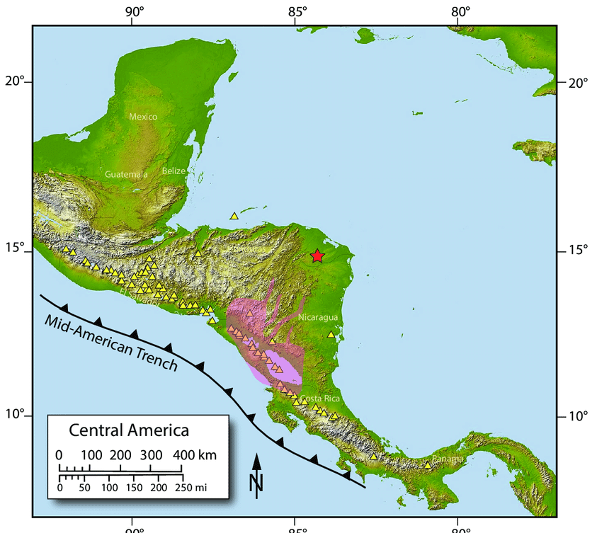
Map depicting the Central American Volcanic Arc with the Middle American Trench to the southwest.