El Salvador: Natural Landscape
El Salvador is the smallest country in Central America, sharing borders with Honduras and Guatemala. It is the only country without a Caribbean coastline. However, El Salvador boasts diverse landscapes, from lush rainforests to towering volcanoes, and is the region's most densely populated country.


 https://www.flickr.com/photos/27781737@N05/39812607194")

, CC BY 3.0, via Wikimedia Commons")


The Natural Landscape of El Salvador
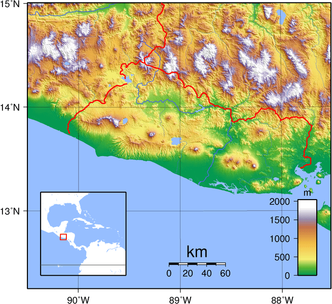
Nestled in northern Central America, El Salvador is strategically positioned, sharing borders with Honduras to the northeast and Guatemala to the northwest. Its geographic location grants it access to the Pacific Ocean and the Gulf of Fonseca, stretching across approximately 307 kilometers (190 miles) of coastline. This unique positioning makes El Salvador the only country in Central America without a shoreline on the Caribbean Sea.
With a total land area of 21,041 square kilometers (8,124 square miles), El Salvador is the smallest country in Central America. Its compact size belies its remarkable diversity, with landscapes ranging from lush rainforests to towering volcanoes. Spanning 270 kilometers (167 miles) from west-northwest to east-southeast and 142 kilometers (88 miles) from north to south, El Salvador is also Central America's most densely populated country.
The Pan-American Highway, CA-1 or Carretera Panamericana, is the nation's main road, connecting El Salvador with its neighboring countries. This vital transportation artery, traversing the country from west to east, facilitates the movement of people and goods, playing a crucial role in El Salvador's economy and development.
El Salvador's geographic position and diverse landscapes have shaped its rich cultural heritage and economic activities. Its access to the Pacific Ocean and the Gulf of Fonseca has fostered a vibrant coastal culture, while its fertile lands support agriculture and coffee production. The country's natural beauty and unique ecosystems have also attracted ecotourism, providing sustainable development and economic growth opportunities.
Biodiversity
El Salvador, though modest in size, harbors a surprising array of ecosystems and species, contributing to its unique biodiversity. While not in the spotlight like some larger neighbors, the country hosts a rich mosaic of life.
The Global Biodiversity Index ranks El Salvador as the 70th most biodiverse nation globally. This country showcases its environmental wealth with 495 bird species, 30 amphibian species, 588 fish species, 156 mammal species, 135 reptile species, and an impressive 2,911 species of vascular plants. These numbers underscore the ecological diversity tucked within the nation's boundaries.
Conservation
In El Salvador, conservation efforts are paramount to safeguard the country's limited natural resources and preserve its biodiversity. Despite its small size and high population density, El Salvador has embraced the responsibility of environmental stewardship, recognizing the intrinsic value of its ecosystems.
Challenges to conservation in this dynamic Central American nation are manifold. Urbanization, pollution stemming from industry and agriculture, over-exploitation of natural resources, and the growing impacts of climate change present formidable hurdles. The limited land area and heightened population density further magnify the urgency of addressing these challenges.
Despite these obstacles, El Salvador is committed to balancing development with conservation. Through strategic measures and a proactive stance, the country endeavors to ensure that its ecological treasures endure for future generations, fostering a delicate equilibrium between progress and
Climate
El Salvador's climate is characterized by a tropical warmth, with temperatures primarily dictated by elevation rather than distinct seasonal shifts. However, the country experiences different wet and dry seasons that shape its agricultural rhythms and natural landscapes.
El Salvador experiences its wet season and abundant rainfall from May to October. During this time, afternoon and evening showers are common, turning the land into lush greenery. In contrast, the dry season from November to April provides a break from the showers, with lower humidity and reduced rainfall. Despite the drier period, the country still receives some precipitation, ensuring a consistent water supply for its residents and ecosystems.
The average temperature in El Salvador is 25 °C (77 °F), but it can vary depending on the altitude and the time of year.
- The Pacific coast of El Salvador is the hottest and most humid region of the country, with temperatures averaging around 27 °C (81 °F) year-round.
- The central highlands are cooler and drier, with temperatures averaging around 22 °C (72 °F).
- The northern mountains are the coolest region of the country, with temperatures averaging around 18 °C (64 °F).
El Salvador's climate is not without its challenges. The country lies within the hurricane belt, making it vulnerable to the wrath of these powerful storms. Hurricanes and tropical cyclones can wreak havoc on infrastructure, disrupt agriculture, and displace communities. Despite these risks, El Salvador's climate remains a defining feature of its identity, shaping its landscapes, influencing its culture, and contributing to its rich biodiversity.
Volcanism
El Salvador, situated within the Pacific Ring of Fire, a region renowned for its volcanic activity, is home to numerous volcanoes and volcanic structures that have shaped its landscapes and geology. Like the rest of Central America, the relatively stable Caribbean Plate is underneath El Salvador. The subduction of the Cocos Plate to the west beneath the Caribbean Plate to the east is responsible for the high frequency of earthquakes and volcanic eruptions in the region.
There are approximately twenty volcanoes along the Central American Volcanic Arc, which spans El Salvador's territory. However, only Izalco, Santa Ana, and San Miguel have been recently active. While El Salvador's volcanoes offer benefits like geothermal energy resources and fertile volcanic soils for agriculture, they also present challenges. The proximity of human settlements to active volcanoes introduces potential risks, necessitating a balanced approach to harnessing the advantages while ensuring the population's safety.
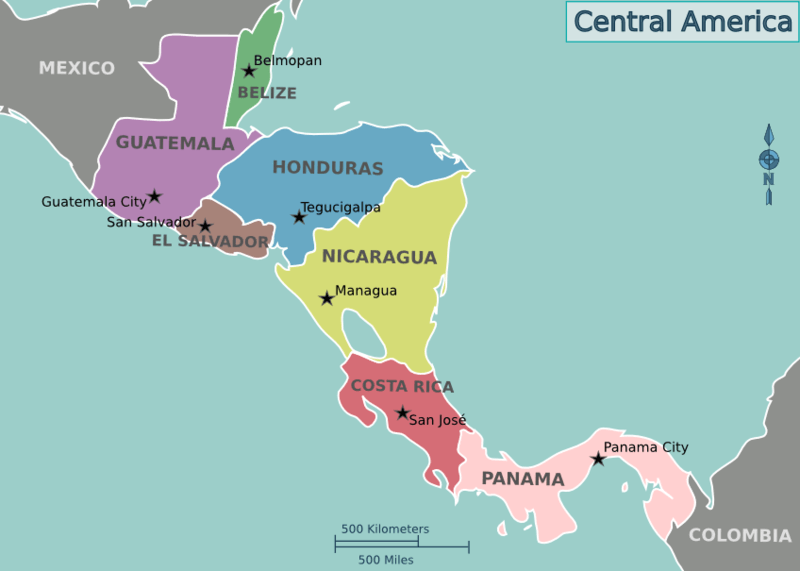
Location map of the countries of Central America.
Natural Geography of El Salvador
El Salvador is divided into three distinct geographic regions or zones: the Pacific Coastal Plain, the Central Plateau, and the Northern Highlands. Each region is characterized by its unique topography, climate, and ecological features, which contribute to the country's landscape's diversity and richness. These three regions play a critical role in shaping El Salvador's natural environment, cultural identity, and economic activities.
Pacific Coastal Plain
The Pacific Coastal Plain (La Llanura Costera del Pacífico) stretches along El Salvador's southern border, parallel to the Pacific Ocean. This region is defined by its flat terrain, sandy beaches, and fertile soils, making it a vital area for agriculture and coastal ecosystems. The fertile lands support the cultivation of crops such as sugarcane, cotton, and tropical fruits, while mangroves and estuaries, particularly those in the Jiquilisco Bay Biosphere Reserve, provide critical habitats for wildlife and protect against coastal erosion. The coastal plain is also a popular tourist destination, offering world-class surfing spots at beaches like El Tunco and El Zonte. The region experiences a hot and humid climate, with average temperatures ranging from 23 to 32 °C (73 to 90 °F), making it one of the warmest areas in the country.
Central Plateau
The Central Plateau (La Meseta Central) lies between the Pacific Coastal Plain and the Northern Highlands, forming the most densely populated and economically active region of El Salvador. This zone consists of rolling hills, valleys, and flatlands shaped by volcanic activity, which has enriched the soil and made the area highly productive for agriculture. Coffee, a major export commodity, is grown extensively in this region, contributing significantly to the country's economy. The Central Plateau is home to the capital city, San Salvador, and other major urban centers like Santa Ana, which serve as hubs for commerce, education, and governance. The area also features active and dormant volcanoes, including the San Salvador and Izalco volcanoes, which are prominent geographical and cultural landmarks. With a temperate climate, the region experiences average temperatures between 17 and 30 °C (63 to 86 °F), offering a more comfortable environment than the coastal areas.
Northern Highlands
The Northern Highlands (La Sierra del Norte), located along the border with Honduras, are characterized by rugged mountains, deep valleys, and remote landscapes. This region is the least populated of the three zones but is rich in ecological and cultural significance. It is part of the Sierra Madre de Chiapas mountain range and includes peaks such as Cerro El Pital, the highest point in El Salvador, rising over 2,000 m (6,562 ft) above sea level. The highlands are home to traditional farming practices and small indigenous communities that preserve the area's cultural heritage. Biodiversity thrives in this region, with cloud forests and protected areas like the Montecristo Trifinio Forest Reserve providing habitats for a variety of flora and fauna. Rivers such as the Lempa River originate in the highlands, supplying water for irrigation and hydroelectric power generation downstream. Due to its elevation, the region enjoys cooler temperatures, ranging from 12 to 24 °C (54 to 75 °F), offering a stark contrast to the warmer lowlands.
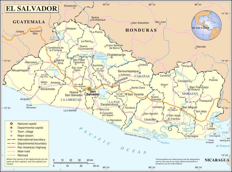
Topographic map of El Salvador.
Islands
El Salvador has a relatively short coastline along the Pacific Ocean, with a few islands and islets. These islands are relatively low-lying and have played a role in local fishing and economic activities. They contribute to the country's coastal geography, albeit on a smaller scale than some other countries in the region. The most notable of these islands include:
Isla Montecristo: Isla Montecristo, also known as Isla Tigre, is a large island in the Gulf of Fonseca, off the coast of El Salvador. With a total land area of 133 sq km (51 sq mi), it is the largest island in the country. The island is home to various wildlife, including monkeys, sloths, and birds.
Meanguera del Golfo: Meanguera del Golfo is an island in the Gulf of Fonseca. It is the second-largest island in El Salvador, with a total land area of 16.68 sq km (6.47 sq mi and a population of about 2,400 people.
Isla Martín Perez: Isla Martín Pérez, also known as Isla Martín Pérez, is a small island located in the Gulf of Fonseca, off the coast of El Salvador, with a total land area of just two sq km (0.8 sq mi). The island's population is about 1,000, and the main town is El Real de la Isla.
Bodies of Water
El Salvador, bordered by the Pacific Ocean, is home to diverse water bodies contributing to its natural beauty and ecological significance. From expansive lakes and picturesque lagoons to bays, gulfs, and meandering rivers, these bodies of water shape the landscape and play essential roles in the country's ecosystem, economy, and recreational activities.
See more: Water Bodies of El Salvador
Administrative Divisions
El Salvador has 14 departments, each administered by a governor appointed by the president. Each department has a capital city and is subdivided into 262 municipalities.
See more: Cultural Landscape of El Salvador
Map of El Salvador.
Natural Regions
Flora and Fauna
The country boasts an abundance of flora and fauna, some of which have been classified as either threatened or vulnerable. Four of the world's eight sea turtles, including the critically endangered hawksbill, nest on the coast of El Salvador, including the critically endangered hawksbill.
Ecological Regions
The following is a list of terrestrial ecoregions in El Salvador, as defined by the World Wide Fund for Nature (WWF). El Salvador is in the Neotropical realm. Ecoregions are classified by biome type - the major global plant communities determined by rainfall and climate.
Tropical and subtropical moist broadleaf forests
Central American montane forests
Tropical and subtropical coniferous broadleaf forests
Central American pine–oak forests
Tropical and subtropical coniferous dry forests
Mangroves
Gulf of Fonseca mangroves
Northern Dry Pacific Coast mangroves
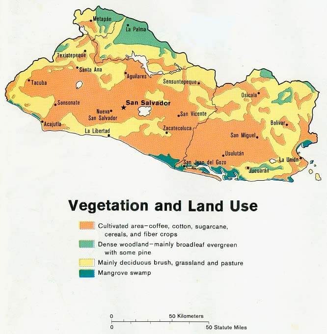
Vegetation and land use map of El Salvador.