Nueva Esparta: Margarita, Cubagua and Coche Islands (Venezuela)
Margarita Island, Cubagua Island, and Coche Island are the largest of 70 islands comprising Nueva Esparta state, situated off the northeastern coast of Venezuela in the Caribbean Sea. Margarita Island was discovered by Columbus in 1498 and is known as the "Isle of Pearls."


 called Playa Puerto Cruz. Hotel at the right is the Dunes Beach Resort Hotel. In the background is the Hesperia Isla Bonita Hotel. The picture was taken from the lighthouse. - public domain")

]")

]")

Nueva Esparta
Nueva Esparta is one of the 23 states of Venezuela. The state is the smallest in total area and is located off the northeast coast of Venezuela in the Caribbean Sea. It is the only insular state of Venezuela. Also known as the "Isle of Pearls," Margarita is the largest of 70 islands comprising Nueva Esparta state.
Nueva Esparta comprises Margarita Island and two small neighbors: Cubagua Island and Coche Island. In addition, there are many additional small islands in the area, but most remain uninhabited and directly depend on the federal government. Its capital city is La Asunción, located on Margarita Island.
The main urban center is Porlamar. Other important towns are Juan Griego, Pampatar, Punta de Piedras, San Juan Bautista, Las Guevaras, Las Hernández, Villa Rosa, Bella Vista, and El Valle del Espíritu Santo.
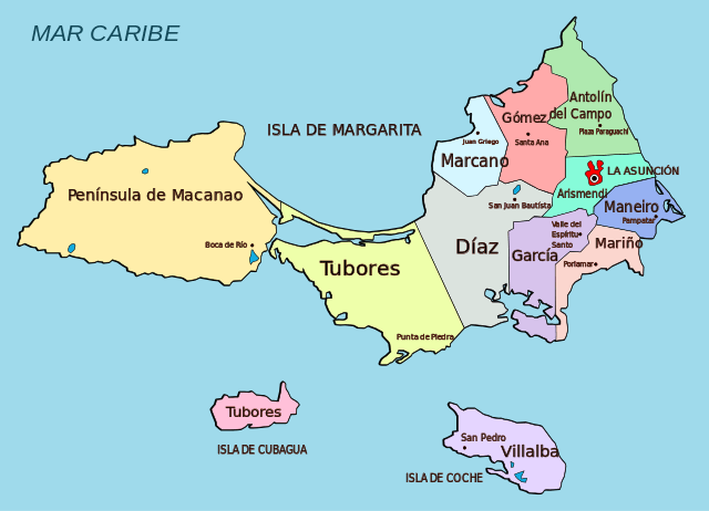
Illustration depicting the territorial political division of Nueva Esparta
Margarita Island
Margarita Island (Isla de Margarita) is situated off the northeastern coast of Venezuela in the Caribbean Sea. Most of the island's 420,000 residents live in the more developed eastern part, including the large cities of Porlamar and Pampatar, along with the state capital of La Asunción.
Although the capital is La Asunción, the most important city is Porlamar, the center of the pearl industry, which has an airport. Besides pearls, primary industries include tourism, fishing and construction.
Isla de Margarita was discovered by Columbus in 1498 and quickly became known for its pearls. Through the centuries, settlements on the island were besieged by Indians (in reprisal for slave raids on the mainland), British pirates, and Dutch forces. Nevertheless, its traders assisted the revolutionists in the struggle for independence from Spain.
Margarita Island is two islands, or two peninsulas, joined by a low, narrow isthmus. The Macanao peninsula to the west has a central mountain range in the east-west direction. The Paraguachoa peninsula to the east is formed by a mountain range in the north-south direction from Porlamar to Cabo Negro.
Margarita Island is about 40 mi (65 km) long, covers an area of 414 sq mi (1,072 sq km) and has a coastline of 198 mi (318 km) with many natural harbors. The island is generally low, but the highest elevation, in the Cerros del Macanao, reaches 2,493 ft (760 m).
The climate is sunny and dry. The average temperature is 32 °C (90 °F), with a minimum ranging between 22 °C (72 °F) and 23 °C (73 °F) and a maximum that can easily exceed 34 °C (93 °F). Rainfall is most common during the winter and rainy seasons that occur July-October.
The vegetation around the hills is desert, with cacti, prickly pears, yaks, and guamaches. The fauna includes desert lizards, rabbits, rattlesnakes, and coral.
Coche Island
Coche Island (Isla de Coche) is one of three islands forming the Nueva Esparta State of Venezuela, located between Isla Margarita and the mainland in the Caribbean Sea. The island was discovered in 1498 by Christopher Columbus, populated by the Waika Rio indigenous people.
The first efforts to settle Coche were made in the early 16th century. A previous population of refugees originated from the city of Nueva Cádiz, which was destroyed by a tropical storm on Cubagua Island. As a result, all settlers abandoned Isla Coche in 1574. The subsequent successful settlement took place in the 19th century, and Coche is still inhabited from this date.
Coche Beach, or Playa La Punta, is located along an extensive sandy tongue at the northwestern tip of Coche Island. It is a world-famous destination for kitesurfing and windsurfing.
Towns on Coche are San Pedro de Coche, El Bichar, Guinima, El Amparo, El Guamache, and La Uva. The economy depends mainly on tourism.
Cubagua Island
Cubagua Island (Isla de Cubagua) is the smallest and least populated of the three islands, constituting the Venezuelan state of Nueva Esparta, after Isla Margarita and Coche. It is located 16 km (10 mi) north of Araya Peninsula, the closest mainland area.
Cubagua is part of the municipality of Tubores, one of 11 municipalities of the state of Nueva Esparta. The island has no streets or roads. Instead, it is served by ferries and other boats from Punta de Piedras on Margarita Island.
Cubagua Island is 9.2 by 3.6 km (5.7 by 2.2 mi) in size and elliptical. The highest elevation of the flat-topped island reaches 32 m (105 ft). It is dry and lacks surface water bodies (the only freshwater is found in small underground reservoirs).
Annual precipitation is 250 mm (10 in), similar to a desert. Temperatures are close to 25 °C (77 °F) year-round, with slight fluctuation. The barren island's desert-like (xerophytic) vegetation includes many cactus species.
Human activity dates from the 24th century BC, but the first people did not settle here permanently. Instead, the island was a source of oysters, food, and pearls. The lack of vegetation or freshwater made permanent settlement nearly impossible. Today, the island still has temporary fishermen but few permanent residents.
Nueva Cádiz, which reached a population between 1,000 and 1,500, was destroyed in an earthquake followed by a tsunami in 1541. The ruins were declared a National Monument of Venezuela in 1979.
In 1498, Cubagua was sighted by Christopher Columbus. In 1528, Cristóbal Guerra founded the city of Nueva Cádiz, the first settlement to hold the title of "city" in Venezuela. The town became a synonym for the suppression by the Hispanic Conquistadores in South America.