The Patuca River: Lifeline of Eastern Honduras
The Patuca River is the longest and most significant river in Honduras. It flows from the mountains of central Honduras to the Caribbean Sea and shapes the geography, ecology, and culture of the eastern region of the country. The river supports a wide array of ecosystems and human settlements.

Navigating the Patuca River: Ecology, Culture, and Challenges
The Patuca River is the longest and most significant river in Honduras, shaping the geography, ecology, and culture of the eastern region of the country. Flowing from the mountains of central Honduras to the Caribbean Sea, it supports a vast array of ecosystems and human settlements. Despite its ecological importance, the river faces challenges from deforestation, hydroelectric projects, and climate change. Understanding the Patuca River's geography, biodiversity, and socioeconomic role highlights its value and the need for conservation efforts.
Geographic Overview
The Patuca River originates in the western highlands of Honduras, formed by the convergence of several tributaries, including the Guayape and Guayambre Rivers. It extends approximately 500 km (310 mi) eastward, cutting through a variety of landscapes, from mountainous terrain to vast lowland plains, before emptying into the Caribbean Sea. As it travels, the river passes through the departments of Olancho, Gracias a Dios, and Colón, regions renowned for their rich biodiversity, Indigenous cultures, and economic activities centered around agriculture and fishing.
The river's basin covers an area of roughly 23,900 km² (9,230 mi²), making it one of the largest watersheds in Central America. This vast watershed collects rainfall from diverse climatic regions, leading to significant seasonal variations in water flow. During the wet season, heavy rains cause the river to swell, increasing the risk of flooding in surrounding lowland areas, while the dry season sees reduced water levels, impacting navigation and water availability for human and ecological needs. The river's floodplain is characterized by an intricate network of wetlands, oxbow lakes, and tributaries that contribute to its ecological complexity.
Biodiversity and Ecosystem Significance
The Patuca River and its surrounding ecosystems are among the most biodiverse in Central America. The river runs through Patuca National Park, a protected area spanning over 3,775 km² (1,457 mi²), which is home to an extraordinary range of flora and fauna. This national park, part of the larger Mosquitia Biosphere, serves as a refuge for iconic species such as jaguars (Panthera onca), Baird's tapirs (Tapirus bairdii), giant anteaters (Myrmecophaga tridactyla), and the endangered Central American river turtle (Dermatemys mawii).
The river and its adjacent wetlands support a wide variety of aquatic life, including numerous fish species, crustaceans, and amphibians that are integral to the diets of both wildlife and human populations. Migratory birds such as herons, kingfishers, and ibises rely on the river's extensive floodplains for nesting and feeding grounds. Additionally, the dense tropical rainforests lining the river provide essential ecological services, including carbon sequestration, climate regulation, and water filtration, which contribute to the overall health of the regional environment.
Human Settlements and Cultural Importance
For centuries, the Patuca River has been an essential lifeline for Indigenous groups and rural communities. The Miskito, Tawahka, and Pech peoples, among the primary inhabitants of the region, have relied on the river for transportation, fishing, and agricultural activities. Traditional fishing techniques, such as the use of hand-woven nets and dugout canoes, have been passed down through generations and continue to play a fundamental role in sustaining local food security.
The river also serves as a crucial transportation route in an area with limited road infrastructure. Many villages and settlements along its banks depend on wooden boats and motorized canoes to access markets, schools, and healthcare services. The region's cultural heritage is deeply intertwined with the river, with local myths, songs, and oral histories reflecting its significance in Indigenous cosmology and daily life. Despite modern influences, the Patuca River remains a cornerstone of traditional knowledge and ecological stewardship in eastern Honduras.
Economic and Developmental Impact
The Patuca River has long been a focal point of economic and developmental interest in Honduras. The region's fertile lands support subsistence and commercial agriculture, with crops such as maize, beans, bananas, and cacao cultivated along its banks. Additionally, fishing remains a primary livelihood for many communities, with species such as tilapia, catfish, and snook providing both food and income.
Hydroelectric development has significantly shaped discussions around the Patuca River's future. The Patuca III Hydroelectric Project, completed in 2018, is one of the largest energy projects in Honduras, generating approximately 104 MW of electricity. While hydroelectric power contributes to the country's energy matrix, it has raised concerns regarding ecological disruptions, including altered water flow, sedimentation buildup, and impacts on fish populations. Further hydroelectric projects have been proposed, prompting debates about balancing energy demands with environmental and social sustainability.
Deforestation in the river's upper basin, driven by cattle ranching, illegal logging, and land conversion, has accelerated soil erosion and sedimentation, affecting water quality and riverbank stability. The expansion of agricultural activities, particularly cattle grazing, has led to habitat loss and increased pressure on local ecosystems. Without sustainable land management strategies, these challenges could further degrade the river's health and threaten the livelihoods of those who depend on it.
Environmental Challenges and Conservation Efforts
The Patuca River faces significant environmental threats, primarily due to deforestation, pollution, and climate change. Soil erosion from logging and agricultural expansion contributes to declining water quality, affecting both aquatic species and human populations that rely on the river for drinking water. Runoff from pesticides and fertilizers used in farming operations has further exacerbated water pollution, leading to potential health risks for communities downstream.
Climate change has introduced additional uncertainties to the Patuca River's hydrology. Changing rainfall patterns have resulted in more frequent extreme weather events, such as prolonged droughts and severe flooding. These climatic shifts impact water availability, disrupt traditional agricultural cycles and increase the vulnerability of riverine communities to natural disasters.
Several conservation initiatives have been implemented to address these environmental challenges. Patuca National Park and the broader Mosquitia Biosphere serve as critical conservation areas, with efforts focused on habitat protection, reforestation, and community-based natural resource management. Indigenous-led conservation programs have also played a key role in preserving traditional ecological knowledge and promoting sustainable fishing and farming practices. Strengthening environmental policies, enforcing regulations against illegal deforestation, and expanding reforestation programs are essential to ensuring the long-term sustainability of the Patuca River and its surrounding ecosystems.
Conclusion
The Patuca River is more than just a geographical feature; it is an ecological and cultural cornerstone of Honduras. Its vast watershed supports diverse wildlife, Indigenous communities, and economic activities, yet it faces mounting pressures from deforestation, hydroelectric development, and climate change. Effective conservation and sustainable management efforts are crucial to preserving this vital river for future generations. Recognizing its significance highlights the necessity of balanced policies that safeguard natural ecosystems while supporting the livelihoods of those who depend on them.
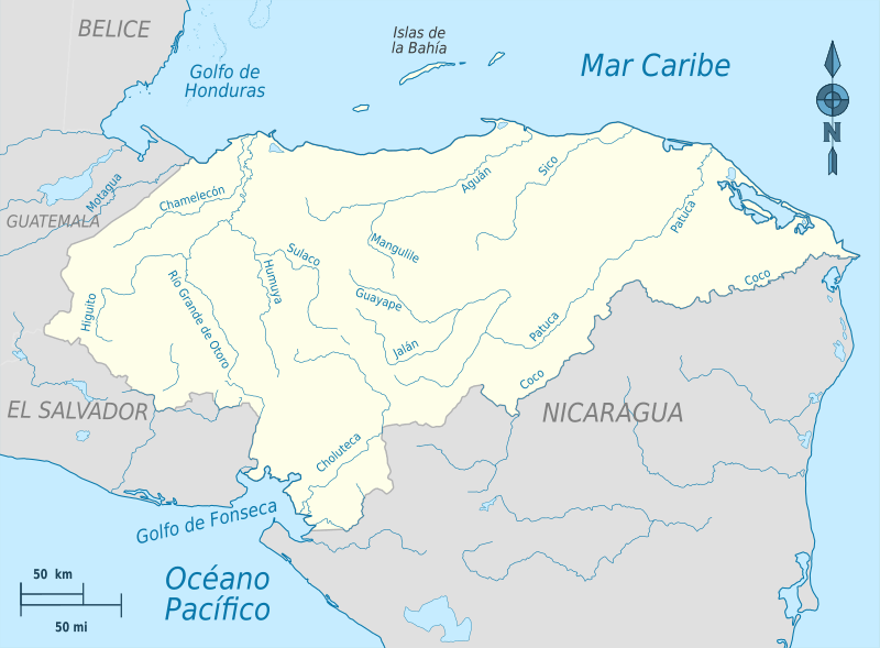
Hydrographic map of Honduras.