Mountain Ranges of Puerto Rico
Puerto Rico's mountain ranges, led by the grandeur of the Cordillera Central, paint a diverse portrait of the island's natural beauty. From Sierra de Cayey's lush greenery to Sierra de Luquillo's tropical splendor and the rustic charm of Sierra Bermeja, each subrange adds a unique layer to Puerto Rico's topography.


Mountain Ranges of Puerto Rico
Nestled in the heart of the Caribbean, Puerto Rico boasts pristine beaches, a vibrant culture, and a captivating network of mountain ranges that adds to the island's diverse landscape. Among these, the Cordillera Central takes center stage, accompanied by its minor ranges – Sierra de Cayey, Sierra de Luquillo, and Sierra Bermeja – each contributing its unique charm to the enchanting topography of Puerto Rico.
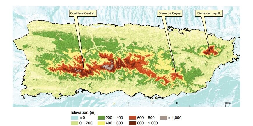
Topographic map of Puerto Rico showing the Cordillera Central and its major subranges.
Cordillera Central
The Cordillera Central, often referred to as the central mountain range, stands as the backbone of Puerto Rico. Stretching from the western to the eastern part of the island, this majestic range is a defining feature of Puerto Rico's geography. Its undulating peaks and verdant valleys create a picturesque panorama, offering breathtaking vistas for those who explore its trails.
The Cordillera Central is not just a visual spectacle but is crucial in Puerto Rico's hydrological system. Many of the island's rivers originate from the central range, providing life-giving water to the surrounding regions. The cool mountain air and lush vegetation offer a refreshing escape from the tropical warmth of the lowlands, making the Cordillera Central a popular destination for nature enthusiasts and hikers.
The Cordillera Central boasts an array of elevations, with its highest peaks reaching impressive heights. Among them, Cerro de Punta stands tall as Puerto Rico's highest point, reaching an elevation of 4,389 feet (1,338 meters). Other notable peaks include Tres Picachos and El Yunque, contributing to the dramatic skyline that characterizes this mountain range.
One of the Cordillera Central's defining features is its rich biodiversity and varied ecosystems. Its various elevations host distinct vegetation zones, from dense tropical rainforests to lush cloud forests. The range is home to many plant and animal species, many of which are endemic to Puerto Rico. The juxtaposition of different ecosystems within the range adds to its ecological significance.
The Cordillera Central serves as a vital source of water for Puerto Rico. Many of the island's rivers, such as the Río Grande de Arecibo and the Río Coamo, originate in the central mountains. These rivers, fed by the abundant rainfall in the region, contribute to the island's water supply, agricultural irrigation, and hydroelectric power generation.
The Cordillera Central holds cultural significance in Puerto Rican history. Indigenous Taíno communities once inhabited its valleys, leaving traces of their presence. Additionally, the central mountains played a role in the island's coffee cultivation, with historic coffee haciendas dotting the landscape.
Beyond its ecological importance, the Cordillera Central provides numerous recreational opportunities for locals and visitors. Hiking trails wind through its verdant landscapes, offering breathtaking views of the surrounding valleys and coasts. Popular destinations within the range include Toro Negro Forest Reserve, home to the impressive Cerro de Punta, and Guilarte Forest Reserve, known for its scenic beauty and hiking trails.
Sierra de Cayey
The Sierra de Cayey, nestled in the southern part of Puerto Rico, is a picturesque subrange of the Cordillera Central mountain range. Situated within the municipality of Cayey, the Sierra de Cayey spans approximately 20 miles. Rolling hills and lush valleys characterize it.
While not reaching the towering heights of some of its neighboring peaks, the Sierra de Cayey offers elevations that provide captivating views of the surrounding landscapes. Though less prominent than the island's highest peaks, the range contributes to the overall charm of Puerto Rico's mountainous interior.
The slopes of the Sierra de Cayey are adorned with diverse flora, including tropical hardwoods and vibrant foliage. The region's ecological diversity supports various animal species, adding to its allure for nature enthusiasts. Hiking trails through the foothills allow visitors to explore the natural beauty of this subrange.
Sierra de Luquillo
The Sierra de Luquillo, situated in the northeastern part of Puerto Rico, is a tropical haven within the Cordillera Central mountain range. Known for its lush rainforests, cascading waterfalls, and diverse ecosystems, this subrange offers a captivating blend of natural beauty and ecological richness.
Nestled within the El Yunque National Forest, the Sierra de Luquillo is renowned as the location of Puerto Rico's only tropical rainforest. This subrange covers approximately 28,000 acres, a prominent feature of the more extensive Cordillera Central, contributing to the island's diverse topography.
While not reaching the highest elevations within Puerto Rico, the Sierra de Luquillo boasts impressive peaks, including El Yunque, which stands at 1,078 meters (3,537 feet). The elevation, coupled with the region's ample rainfall, creates a microclimate that supports the growth of various plant and animal species.
The Sierra de Luquillo is a biodiversity hotspot, hosting a plethora of flora and fauna endemic to Puerto Rico. Verdant forests are home to vibrant orchids, giant ferns, and tropical hardwoods. The subtropical rainforest provides diverse wildlife habitats, including the critically endangered Puerto Rican parrot and the unique coqui frog.
One of the defining features of the Sierra de Luquillo is its network of cascading waterfalls and pristine rivers. La Mina Falls, Juan Diego Falls, and Coca Falls are among the picturesque waterfalls that grace the landscape, offering refreshing swimming spots for those exploring the region's hiking trails.
Sierra Bermeja
Nestled in the western part of Puerto Rico, the Sierra Bermeja adds a touch of rustic charm to the island's landscape. While not as towering as some of its counterparts, this subrange within the Cordillera Central offers a tranquil retreat characterized by rolling hills, pastoral scenes, and a distinct red-hued soil.
The Sierra Bermeja is situated in Cabo Rojo, contributing to the diverse topography of the Cordillera Central. Spanning a picturesque landscape, this subrange is known for its gentle slopes and scenic vistas.
Although not reaching the towering heights of some Puerto Rican peaks, the Sierra Bermeja provides elevated vantage points that afford sweeping views of the surrounding countryside. Its prominence lies in the subtle undulations of its hills rather than dramatic peaks.
A blend of agricultural lands and patches of natural vegetation characterizes the Sierra Bermeja. The region's red soil is a distinctive feature contributing to its name. While not as densely forested as some other subranges, the area supports a variety of flora and fauna, with agricultural activities complementing the natural landscape.
The red soil of the Sierra Bermeja has long been associated with agriculture. The region has been utilized for farming, and the earth's distinctive color is a testament to the area's agricultural history. The patchwork of fields and the contrast of green vegetation against the red soil create a picturesque and pastoral ambiance.