The Maya Mountains: Ancient Peaks at the Heart of Belize's Wilderness
The Maya Mountains, a rugged and enigmatic range situated primarily in west-central Belize and extending into eastern Guatemala, are a testament to geological forces and human history. This ancient mountain range has been pivotal in shaping the region's landscape, biodiversity, and cultural heritage.
 via Wikimedia Commons")
 via Wikimedia Commons")
 via Wikimedia Commons")
 via Wikimedia Commons")
 via Wikimedia Commons")

From Doyle's Delight to Cockscomb: Exploring Belize's Maya Mountains
Rising dramatically from the coastal plains and limestone lowlands of west-central Belize and extending into eastern Guatemala, the Maya Mountains stand as both the geological backbone and ecological heart of the nation. This ancient mountain range, composed primarily of Paleozoic-era granite and sediments dating back over 300 million years, represents one of Central America's oldest geological features and plays a pivotal role in shaping the region's landscape, biodiversity, and cultural heritage. At the range's apex rises Doyle's Delight at 1,124 meters (3,688 feet)—Belize's highest peak, named after Sir Arthur Conan Doyle, whose 1912 novel "The Lost World" described these mountains as beautiful and wild places. From towering peaks to hidden valleys, the Maya Mountains form the centerpiece of Belize's conservation efforts, including the critical Maya Mountain Marine Corridor that connects these highlands to Caribbean coastal waters.
Geographic Extent and the Cockscomb Range
The Maya Mountains occupy approximately 4,000 square kilometers (1,500 square miles) across Belize's Cayo, Stann Creek, and Toledo districts, with extensions into Guatemala's Petén department. This ancient uplift creates Belize's most dramatic topographical feature, contrasting sharply with the flat limestone lowlands that characterize much of the country.
One of the most prominent features is the Cockscomb Range, a spur extending perpendicularly east-west from the main divide for approximately 16 kilometers (10 miles). Named for its resemblance to a rooster's comb, this range contains Belize's highest peaks. Doyle's Delight at 1,124 meters (3,688 feet) remained relatively unknown until officially measured in the 1970s.
Victoria Peak, the second-highest at 1,122 meters (3,681 feet), rises within the Cockscomb Basin Wildlife Sanctuary in Stann Creek District. The steep slopes and rugged terrain create numerous waterfalls throughout the range, including the spectacular Thousand Foot Falls (487 meters or 1,600 feet), which plunges dramatically into the valley below near the Mountain Pine Ridge Forest Reserve.
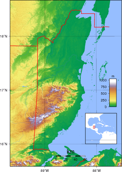
Topography map of Belize depicting the Maya Mountains and Cockscomb Range.
Geology and Climate
Unlike much of Belize, which consists of marine limestone, the Maya Mountains represent a much older geological formation. The range's core comprises Paleozoic granite, schist, slate, and sandstone—some of the oldest rocks in Central America, dating back 300-400 million years. This geological composition creates nutrient-poor, acidic soils that support distinct plant communities.
The mountains profoundly influence Belize's climate and serve as the nation's primary watershed. While coastal areas receive 1,270-1,905 millimeters (50-75 inches) of annual rainfall, the mountainous interior can experience up to 4,064 millimeters (160 inches) per year.
This abundant precipitation feeds numerous rivers, including the Belize River, the nation's longest waterway at approximately 290 kilometers (180 miles), along with the Sibun, Sittee, Monkey, Moho, and Temash rivers—all originating in these highlands. The mountains' role as a water tower for Belize cannot be overstated, as dense forest cover intercepts rainfall, moderates streamflow, prevents erosion, and maintains water quality.
Biodiversity and Forest Ecosystems
The Maya Mountains support extraordinary biodiversity across multiple forest types that vary with elevation, rainfall, and soil conditions.
Lowland and Submontane Tropical Forests clothe the lower elevations, featuring tall broadleaf evergreen trees including mahogany (Swietenia macrophylla), sapodilla (Manilkara zapota), and ceiba (Ceiba pentandra). These diverse forests support rich wildlife assemblages, including jaguars (Panthera onca)—Belize hosts one of Central America's healthiest jaguar populations—Baird's tapir (Tapirus bairdii), white-lipped peccaries (Tayassu pecari), and five species of wild cats, including pumas (Puma concolor), ocelots (Leopardus pardalis), and margays (Leopardus wiedii).
The mountains provide critical habitat for endangered primates, including the Yucatán black howler monkey (Alouatta pigra), endemic to the Yucatán Peninsula, and Geoffroy's spider monkey (Ateles geoffroyi).
Avian diversity is exceptional, with over 390 bird species recorded. The scarlet macaw (Ara macao), once nearly extirpated from Belize, maintains its largest population in the Chiquibul National Park. Other notable species include the keel-billed toucan (Ramphastos sulfuratus)—Belize's national bird—the ornate hawk-eagle (Spizaetus ornatus), and the ocellated turkey (Meleagris ocellata).
Mountain Pine Forest occurs at higher elevations on nutrient-poor soils, dominated by Caribbean pine (Pinus caribaea). These open-canopy forests feature grassy understories and support wildlife assemblages different from those of broadleaf forests.
Cultural and Archaeological Significance
The Maya Mountains hold profound cultural significance, bearing the name of the ancient civilization that flourished throughout this region. The mountains' periphery hosted numerous Maya settlements, with archaeological sites including Caracol, Lubaantun, Nim Li Punit, and Pusilha all located within or near the range.
Caracol, situated in the Chiquibul Forest Reserve, ranks among Mesoamerica's largest ancient cities. At its peak around 650 CE, Caracol supported a population exceeding 100,000. The site's most imposing structure, Caana ("Sky Palace"), rises 43 meters (141 feet) above the jungle floor—still the tallest man-made structure in Belize.
The Maya utilized the mountains' resources, including timber, game, medicinal plants, and water, while caves within the limestone foothills held deep religious significance as portals to the underworld (Xibalba).
Protected Areas and Conservation
The Maya Mountains form the core of Belize's protected area system, with multiple reserves and national parks safeguarding significant portions of the range.
Chiquibul National Park (106,838 hectares/263,000 acres) protects the southern Vaca Plateau and eastern Maya Mountain slopes, including Doyle's Delight. The park encompasses portions of the Chiquibul Cave System—the longest cave system in Central America—and supports the largest scarlet macaw population in Belize.
Cockscomb Basin Wildlife Sanctuary, established in 1986 as the world's first jaguar preserve, protects approximately 400 square kilometers (150 square miles) of forests and watersheds, supporting one of the healthiest jaguar populations in Central America.
Mountain Pine Ridge Forest Reserve encompasses pine forests, broadleaf forests, waterfalls, including the Thousand Foot Falls, and caves, providing important ecosystem services, including water production and carbon storage.
Bladen Nature Reserve (39,650 hectares/98,000 acres) preserves untouched wilderness with no trails or visitor facilities, serving as a reference site for scientific research on undisturbed tropical ecosystems.
Collectively, these protected areas form part of the Maya Mountain Massif—a contiguous block of protected forests covering over 400,000 hectares (1 million acres) that extends from the mountains to the Caribbean Sea through the Maya Mountain Marine Corridor.
Conservation Challenges and Future
Despite strong legal protection, the Maya Mountains face ongoing challenges, including illegal logging, hunting, and incursions from Guatemala into Chiquibul National Park. The Maya Forest Corridor connecting the Maya Mountains to forests in northern Belize has experienced deforestation rates four times the national average, driven by agricultural expansion.
Climate change poses long-term threats through altered precipitation patterns and potential shifts in species distributions. A 2023 University of Florida study found that reforestation efforts in the Maya Mountains could significantly enhance carbon storage and biodiversity recovery over the next two decades.
The Maya Mountains represent irreplaceable natural and cultural heritage. As Belize's primary watershed, biodiversity stronghold, and connection to ancient Maya civilization, these ancient peaks deserve sustained conservation commitment. Recent initiatives offer hope, but ensuring these natural and cultural treasures endure requires continued collaboration among government agencies, conservation organizations, local communities, and international partners committed to preserving Central America's most extraordinary mountain range.