The Maya Region: A Journey through Peaks, Lowlands, and Plateaus
The Maya Region spans present-day Guatemala, Belize, and Mexico and is known for its diversity. It encapsulates the historical and cultural landscape of the Mayan civilization in the pre-Columbian era, stretching from the Sierra Madre to northern Yucatán.
 via Wikimedia Commons")
The Maya Region: A Journey through Peaks, Lowlands, and Plateaus
The expansive heart of Mesoamerica, the Maya Region, unfolds as a landscape of unparalleled diversity spanning present-day Guatemala, Belize, and Mexico. Stretching from the mountainous peaks of the Sierra Madre to the semi-arid plains of northern Yucatán, this vast expanse encapsulates the historical and cultural landscape of the Mayan civilization in the pre-Columbian era.
The Maya Region is known for its distinct geological features, consisting of a limestone plateau that gradually ascends towards the south until it meets the mountainous region. This complex geological structure affects the terrain and the availability of water resources, contributing to the diverse landscapes that define the region.
The climate in the Maya Region is diverse, with low-lying areas prone to hurricanes and tropical storms from the Caribbean. The region can be divided into three zones with distinct climate characteristics. The highlands have a cool and temperate climate, while the lowlands are tropical and subtropical.
Southern Maya Highlands
The Southern Maya Highlands is a mesmerizing region that covers the elevated landscapes of Guatemala and the Chiapas highlands. It displays a charming tapestry of geological marvels and environmental resilience. The area is dominated by the commanding presence of the volcanic Sierra Madre mountains, which is a testament to the awe-inspiring forces of nature and the enduring adaptability of the ecosystems that thrive in it.
Volcanic Dominance
The breathtaking peaks of the Sierra Madre mountains define the Southern Maya Highlands. These volcanic mountains are the essence of the region, and each has its unique character. Some of the most noteworthy of these geological wonders are the active volcanoes. Pacaya is known for its effusive eruptions and molten lava displays. Santiaguito is a constantly active volcanic complex. Fuego lives up to its name with frequent fiery displays. Tacaná is the highest peak in Central America, reaching an elevation of 4,220 meters (13,845 feet). The constant geological activity in the region paints a dynamic portrait of the area where the earth's forces are in constant flux.
Geothermal Dynamics and Environmental Challenges
Geothermal activity is present throughout the Southern Maya Highlands, which causes a delicate interplay between the internal heat of the earth and the surface world. The active volcanoes in the region shape its topography and impact the microclimates and soil composition. However, this geological richness also brings its own set of challenges. Earthquakes are frequent occurrences, indicating the tectonic activity underlying the highlands. The undulating landscapes of the region are sometimes affected by flooding, and mudslides triggered by heavy rains underscore the geological dynamism of the area. Nevertheless, life has persisted amidst these challenges, adapting to the ever-changing contours of the Southern Maya Highlands.
Climate and Vegetative Abundance
Despite being in a highland region, the Southern Maya Highlands have a cool and temperate climate. The elevation, combined with the surrounding volcanic peaks, contributes to a misty environment and comfortable temperatures. Despite volcanic disturbances, the highlands are covered in thick vegetation, showing plant life's resilience. The eastern parts of the highlands are somewhat drier and add a unique climatic diversity, creating a range of ecosystems that enrich the environment.
Living in Harmony with Nature
Communities in the Southern Maya Highlands have established a coexistence with the ever-changing geological forces that shape their surroundings. They demonstrate a harmonious relationship with the land through traditional practices such as terrace farming on the slopes of the mountains. The adaptation of agriculture to the various microclimates reflects the resourcefulness of the inhabitants and showcases how human societies can thrive amidst environmental challenges.
Southern Maya Lowlands
Just north of the majestic Southern Maya Highlands, the Southern Maya Lowlands unfurl like a verdant tapestry. They encompass the enchanting expanse of the Petén in northern Guatemala, Belize, and portions of Campeche and Quintana Roo in Mexico. This region, intimately connected to the lifeblood of the highlands, presents a captivating landscape where rivers, lakes, and a tropical symphony of flora and fauna weave a tale of ecological richness.
Rivers, the Lifelines of Abundance
Originating in the highlands, mighty rivers like the Usumacinta and the Pasion gracefully meander through the Southern Maya Lowlands, bestowing the land with their life-giving waters. More than mere watercourses, these rivers are the pulsating veins that nourish the region's lush vegetation and sustain an intricate web of life. This continuous flow of water shapes not only the physical geography but also the cultural and ecological identity of the Southern Lowlands.
Lakes, Vital Reservoirs of Life
The Southern Maya Lowlands boasts a network of lakes, with Lake Petén Itza a significant jewel in this watery crown. Like reflective mirrors nestled amidst the greenery, these lakes contribute to the region's biodiversity and serve as vital reservoirs of life. Lake Petén Itza, in particular, holds historical and ecological significance, offering a habitat for diverse aquatic species and acting as a center for human activities, past and present.
Climate and Rainfall
The Southern Maya Lowlands, blessed by abundant rainfall, revel in a tropical and sub-tropical climate. The harmonious dance of precipitation and sunlight creates an environment where life flourishes in a riot of colors and sounds. The interplay of climate and geography shapes diverse ecosystems, from dense rainforests to open savannas, each providing a niche for many plant and animal species.
Rich Biodiversity
Abundant rainfall and the mosaic of landscapes in the Southern Maya Lowlands converge to create a habitat that supports an extraordinary diversity of flora and fauna. The region becomes a living canvas where vibrant orchids, towering hardwoods, and intricate ferns coexist with myriad wildlife. Jaguars, tapirs, toucans, and howler monkeys are just a few of the charismatic inhabitants of this rich ecosystem, contributing to the biodiversity that defines the Southern Lowlands.
Human-Environment Symbiosis
Indigenous communities in the Southern Maya Lowlands have cultivated a deep connection with this bountiful environment. Traditional agricultural practices, including milpas (rotational swidden fields), reflect a symbiotic relationship between humans and nature, showcasing the sustainable use of the land over centuries. This interdependence is ingrained in the cultural fabric, emphasizing the need to preserve the delicate ecological balance.
Northern Maya Lowlands
The Yucatán Peninsula boasts the vast expanse of the Northern Maya Lowlands, characterized by subtle topographic changes, climatic variations, and unique geological formations. This flat terrain is interrupted by the Puuc hills, which provide a relief and make for a distinctive feature in the region. The lowland region is expansive and covers a large territory.
Topographic Variations and the Puuc Hills
The northern lowlands of Yucatán have generally flat terrain, but the Puuc hills in central and southern Yucatán contrast this with their undulating landscape. These hills are mainly made up of limestone formations and add complexity to the region's geography. This variation affects water drainage and the distribution of vegetation.
Climate Dynamics: From Aridity to Rainfall
The Northern Maya Lowlands experience subtle yet significant variations in climate. The northwest part of the region is characterized by semi-arid conditions, which significantly influence the landscape. In contrast, the northeastern part receives more rainfall, which nourishes the land. This climatic contrast results in diverse ecological zones within the northern lowlands, each with unique flora and fauna adapted to the prevailing conditions.
Scarce Surface Water and the Cenotes' Role
Surface water is a valuable resource in the Northern Maya Lowlands, where some areas are arid. However, nature has a way of creating life-sustaining features like cenotes. These natural sinkholes dot the landscape and are often connected to underground rivers. Cenotes serve as crucial water sources for the environment and human communities. They are geological features and lifelines that sustain life in areas where surface water is scarce.
The Water Table and Human Settlement
Beneath the seemingly flat expanse of the Northern Maya Lowlands is an essential resource - the water table. Although not very deep, the water table is crucial in sustaining communities. It enables the excavation of wells once the bedrock cap is pierced, providing access to fresh water for both agricultural and domestic purposes. The delicate balance between the water table and human settlement highlights the interplay between geology and the foundations of human habitation in the Yucatán Peninsula.
Human Adaptation and Coexistence
Communities in the Northern Maya Lowlands have demonstrated impressive adaptation to the region's geology and climate. They have developed traditional techniques, such as building aguadas (small reservoirs) and growing drought-resistant crops, which showcase the resilience of civilizations in managing the fragile ecological balance of the northern lowlands. The interplay between geological features and human settlement highlights the intricate relationship between nature and culture.
The Maya Region is a remarkable showcase of the adaptability and resilience of ancient civilizations. It boasts various geological features and climates, from the cool highlands to the southern lowland rainforests and the arid expanses of the north. The landscape tells the story of human history, making it a living mosaic. Understanding and appreciating this ecological tapestry is essential for unraveling the complexities of the Mayan civilization and the intricate dance between human societies and their environments.
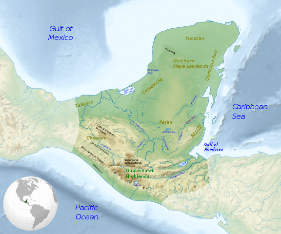
Map of the Maya region, with major rivers, mountain ranges, and regions.