
The Yucatán Peninsula: A Living Testament to Time
Suspended between the Gulf of Mexico and the Caribbean Sea, the Yucatán Peninsula is a 181,000-sq-km limestone platform spanning three Mexican states and reaching into Belize and Guatemala — a landscape shaped by an asteroid impact 66 million years ago, riddled with thousands of sacred cenotes, and home to some of the Maya world's most iconic cities.

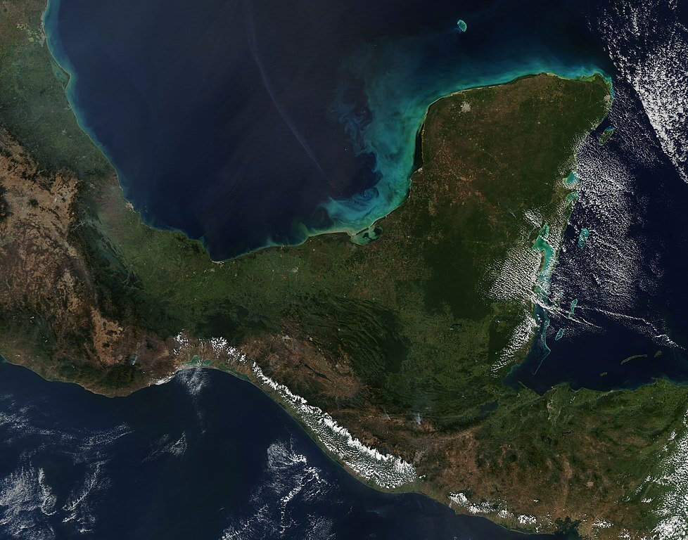
The Yucatán Peninsula: Limestone, Impact, and the Maya World Above
Suspended between the waters of the Gulf of Mexico and the Caribbean Sea, the Yucatán Peninsula is one of the most geologically and culturally distinctive regions in the Americas. This vast limestone platform, covering approximately 181,000 sq km (70,000 sq mi), spans the Mexican states of Campeche, Quintana Roo, and Yucatán, and extends southward into Belize and Guatemala. Here, the peninsula's foundations tell a story that stretches from a cataclysmic asteroid impact to the rise of one of the ancient world's most sophisticated civilizations.
An Ancient Wound Beneath the Limestone
Sixty-six million years ago, as the Cretaceous period drew to a close, an asteroid roughly 10 km (6.2 mi) in diameter struck the shallow seas that then covered the northern Yucatán. The impact created a crater some 200 km (124 mi) in diameter and triggered a chain of events that led to the extinction of the non-avian dinosaurs and countless other species, one of the most consequential single events in the history of life on Earth. Today, the Chicxulub crater lies buried beneath roughly 1 km (0.6 mi) of limestone sediment, and its presence is revealed mainly through careful geological analysis and the telltale arrangement of the peninsula's cenotes, which trace the crater's buried rim in a feature known as the Ring of Cenotes. The crater ranks among the best-preserved impact structures on Earth, offering scientists a rare window into the processes that have shaped the planet's history.
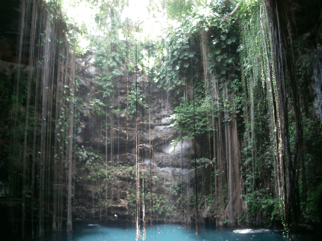
Beneath the peninsula's flat surface lies a hydrological system built directly on this same geology. The entire Yucatán Platform rests on porous limestone, carved over millions of years by slightly acidic groundwater in a process called karstification, creating a vast underground network of caves, caverns, and rivers extending for thousands of kilometers beneath the surface. The cenotes, from the Maya "dzonot," meaning sacred well, are the visible windows into this hidden world: natural sinkholes, numbering in the thousands across the peninsula, ranging from open pools reflecting the sky to caverns hidden beneath cathedral-like limestone ceilings. The ancient Maya considered them portals to the underworld, and archaeological finds recovered from cenotes throughout the region- jade, gold, ceramics, and in some cases human remains- testify to their profound spiritual significance.
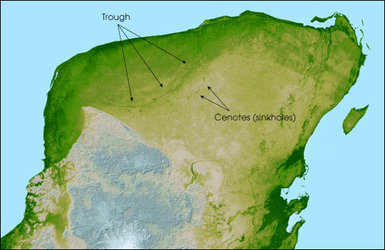
Relief map of the Yucatan Peninsula.
Climate and Ecological Gradients
The peninsula's climate shifts markedly from north to south. In the north, the Yucatecan plains experience a pronounced dry season, supporting thorny deciduous tropical dry forest that takes on an almost desert-like character during the winter months; species such as the collared peccary (Pecari tajacu) and white-tailed deer (Odocoileus virginianus) have adapted to these conditions, relying on cenotes and a keen ability to locate hidden moisture sources when surface water becomes scarce. Moving south toward the Petén region of Guatemala, the climate becomes more consistently humid, supporting the lush, moist forests covered in greater depth in our Petén Basin and Maya Forest article; this gradient creates a natural transition zone where species from different ecological realms overlap. The peninsula's position within the Atlantic hurricane belt also subjects it to the annual tropical storm season, with storms capable of reshaping the landscape within hours; many of the region's species have evolved alongside these disturbances and depend on the periodic renewal they bring to the forest.
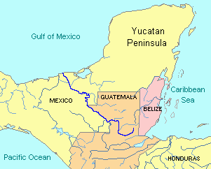
Political map of the Yucatán Peninsula.
A Mosaic of Life Across the Peninsula
The Yucatán Peninsula's biodiversity unfolds across a mosaic of distinct ecoregions. The Yucatán Moist Forests create dense, humid sanctuaries where epiphytes drape from nearly every available surface, and where the great curassow (Crax rubra) finds refuge in the canopy; these forests serve as important corridors for wildlife movement and genetic exchange linking the peninsula to the broader Maya Forest system to its south. The Yucatán Dry Forests have a very different character, with an open, savanna-like structure dominated by drought-resistant species that shed their leaves during the dry season; here, the Baird's tapir (Tapirus bairdii) follows ancient pathways between scattered water sources alongside the peccary and deer already mentioned.
Along the coast, extensive mangrove systems, dominated by red mangrove (Rhizophora mangle) and black mangrove (Avicennia germinans), rank among the most productive ecosystems on Earth, serving as nurseries for countless marine species while protecting the coastline from storms and erosion; American flamingos (Phoenicopterus ruber) filter-feed in the shallow lagoons these mangroves create. Offshore, the Mesoamerican Reef System, the second-largest coral reef system in the world, extends along the peninsula's Caribbean coast, where Nassau grouper (Epinephelus striatus) patrol the reef walls and green sea turtles (Chelonia mydas) glide through the clear water above.
The Living Legacy of the Maya
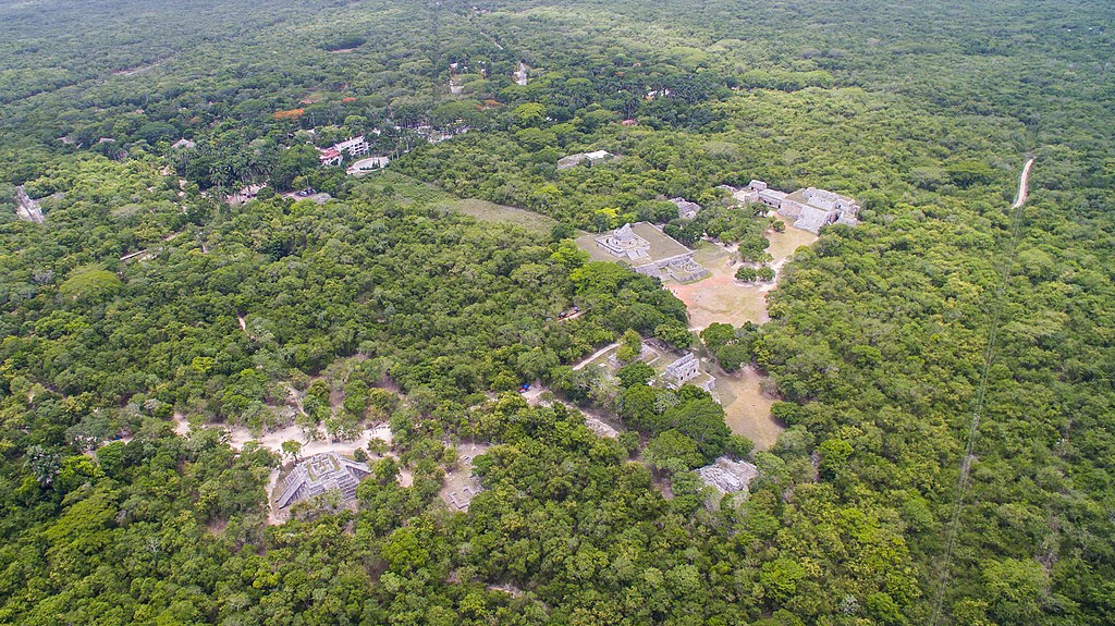
Throughout the peninsula, the architectural achievements of Maya civilization rise from the landscape in stone. Chichén Itzá, with its precisely proportioned Pyramid of Kukulcán, demonstrates a sophisticated understanding of astronomy and mathematics; the structure's design produces acoustic phenomena and shadow effects that mark the progression of the seasons, connecting human observation with cosmic cycles in ways that continue to draw visitors today. Uxmal's Palace of the Governor stretches across the landscape with mathematical precision, its facade adorned with intricate stone mosaics, while Tulum perches on Caribbean cliffs, its walls once protecting one of the Maya world's most important trading ports while serving as a landmark for ancient mariners navigating the reef systems offshore.
These sites represent far more than tourist destinations; they testify to a civilization that achieved a remarkable degree of harmony with its natural environment. The Maya possessed an intimate understanding of the forest, the cenotes, and the stars, knowledge that enabled them to build sustainable communities across one of the world's more demanding tropical landscapes, and which is explored in still greater depth, alongside the great inland cities of Tikal, Calakmul, and El Mirador, in our Petén Basin and Maya Forest article.
Conservation in an Era of Change
Today, the Yucatán Peninsula faces mounting pressure as modern development meets ancient ecosystems. The forest that once stretched unbroken across the region now exists as a patchwork of protected areas surrounded by expanding agriculture and growing urban centers. Conservation efforts, including the ongoing expansion of Mexico's Calakmul Biosphere Reserve and its surrounding complex of connected protected areas to over 1.3 million hectares (3.2 million acres), represent important steps toward maintaining the ecological integrity that has sustained the region for millions of years.
The cenote system, which supplies freshwater to millions of people across the peninsula, faces its own threats from pollution, over-extraction, and development pressure. These wells, revered by the ancient Maya as portals to the underworld, now serve a more prosaic but no less critical role as indicators of environmental health across the region.
Conclusion
The Yucatán Peninsula stands as a record of deep time and the resilience of life built upon it: from the asteroid impact that created the Chicxulub crater, to the patient work of water carving the cenote system beneath it, to the civilization that rose above it and still shapes how the region is understood today. Standing at the edge of a cenote, or walking beneath a forest canopy where jaguars still move along paths first cleared centuries ago, is to encounter a landscape that connects human history to some of the deepest processes of the planet itself.