Guatemala: Natural Landscape
Guatemala is the third-largest country in Central America. Situated in a geologically active region, its geography is characterized by three major geographic regions or zones: the Petén lowlands, the Guatemalan highlands, and the Pacific coast flatlands. It stands out for its extraordinary biodiversity.

, https://www.flickr.com/photos/lonqueta/5526401025")
 / Mexico (right) border - by Fernando Reyes, CC BY-SA 2.0, via Wikimedia Commons")
 https://www.flickr.com/photos/cifor/40850665302")
 - by CrazyKnight, CC BY-SA 3.0, via Wikimedia Commons")
 https://www.flickr.com/photos/worldresourcesinstitute/15601174125")
 https://www.flickr.com/photos/aliarda/438139855")


, https://www.flickr.com/photos/worldbank/13952099199")
 https://www.flickr.com/photos/youngrobv/509294793")
The Natural Landscape of Guatemala
Situated in northern Central America, Guatemala shares borders with Mexico to the north and west, Belize and the Gulf of Honduras to the northeast, Honduras to the east, El Salvador to the southeast, and the Pacific Ocean to the south.
Guatemala is the third-largest country in Central America, covering an expanse of approximately 108,890 square kilometers (42,043 square miles). It is noteworthy, however, that Guatemala has historically asserted territorial claims over areas currently administered by Belize. Despite the passage of many years, the ongoing territorial dispute between Guatemala and Belize remains unresolved.
Biodiversity
Nestled in Central America, Guatemala stands out for its extraordinary biodiversity, earning its status as one of the world's biodiversity hotspots. The country's diverse topography, encompassing tropical rainforests, cloud forests, highland plateaus, and coastal regions, fosters a rich variety of plant and animal life.
Guatemala is 32nd globally in terms of biodiversity. Its ecological landscape provides a home for an impressive spectrum of species, including approximately 699 bird species, 165 amphibian species, 905 fish species, 219 mammal species, 284 reptile species, and a staggering 8,681 vascular plant species.
Conservation
In a proactive approach to conservation, Guatemala has instituted a network of protected areas, national parks, and reserves dedicated to preserving its natural resources and diverse ecosystems. Tikal National Park and the Maya Biosphere Reserve stand out as notable examples.
However, Guatemala faces challenges in its biodiversity conservation efforts. Deforestation, habitat degradation resulting from agricultural expansion and urban development, illegal logging, and wildlife trafficking pose significant threats. Indigenous communities, often residing in areas characterized by high biodiversity, play a pivotal role in conservation initiatives, and their involvement is crucial in addressing these challenges.
Climate
Positioned within the tropics and featuring elevations from sea level to over 4,000 meters (13,000 feet), Guatemala exhibits diverse climates dictated by regional variations, encompassing warm and humid conditions to cooler and drier environments.
The country adheres to a tropical climate pattern characterized by two distinct seasons: the wet season, which lasts from May to October, and the dry season, which lasts from November to April. The average temperature across Guatemala is 25 °C (77 °F), although this can fluctuate based on altitude.
Coastal areas of Guatemala register the highest temperatures and humidity levels, with average temperatures ranging from 27 to 32 °C (81 to 90 °F). In contrast, the highland regions experience cooler and drier conditions, with average temperatures ranging from 18 to 24 °C (64 to 75 °F).
During the wet season, Guatemala encounters substantial rainfall, predominantly afternoons and evenings, while the dry season witnesses reduced precipitation and lower humidity levels. It's noteworthy, however, that even in the dry season, Guatemala still experiences some rainfall.
Volcanism
Guatemala is one of the world's most volcanically active nations, experiencing frequent seismic events and volcanic phenomena due to its location along the Central America Volcanic Arc, a Pacific Ring of Fire segment.
The country's geological dynamics are shaped by the intricate interaction of three tectonic plates: the North American Plate to the north, the Caribbean Plate to the south, and the Cocos Plate to the southwest. This complex tectonic setting is marked by four crucial fault lines: the Motagua fault, the Jalpatagua fault, the Chixoy-Polochic fault, and the Jocotán-Chamelecón fault.
Guatemala boasts a total of 288 volcanic structures, of which approximately 37 are recognized as volcanoes, with three identified as highly active:
- Santiaguito/Santa María: 2,500 m (8,202 ft)
- Fuego: 3,835 m (12,582 ft)
- Pacaya: 2,552 m (8,371 ft)
The highest peak in Central America, Volcán Tajumulco, rises in western Guatemala at 4,220 m (13,845 ft). It forms part of the Sierra Madre de Chiapas, which originates in southern Mexico. Most of Guatemala's volcanoes are situated within this mountainous range.
The historical city of Antigua Guatemala faces proximity to three volcanoes, presenting potential risks:
- Volcán Agua: 3,760 m (12,350 ft)
- Volcán Fuego: 3,763 m (12,336 ft)
- Volcán Acatenango: 3,976 m (13,045 ft)
These geographic features underscore the dynamic interplay between human settlement and the active volcanic landscape in Guatemala.
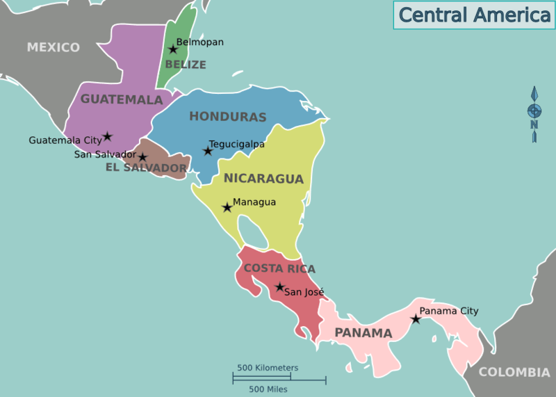
Location map of the countries of Central America
Natural Geography of Guatemala
Geographic Zones
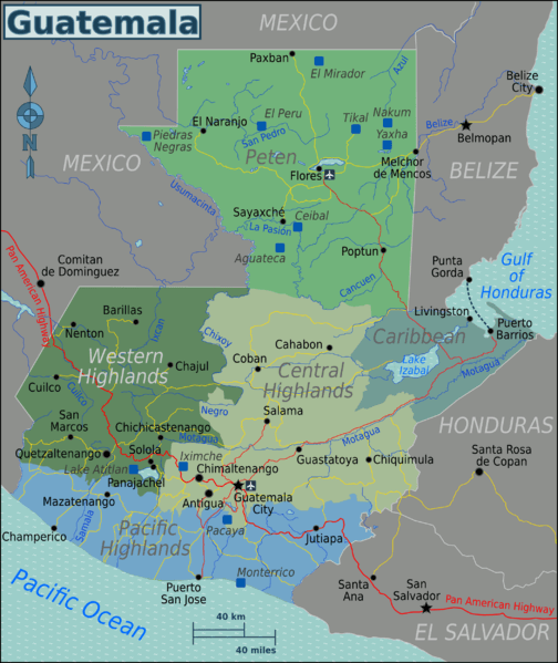
The surface of Guatemala is characterized by three major topographical features that can also be defined as geographic regions or zones: the Petén Lowlands, the Guatemalan Highlands, and the Pacific Coast Flatlands. A fourth minor zone can also be defined: the Caribbean Coast.
The northern third of Guatemala is a vast limestone flatland known as Petén. Once covered entirely in tropical forests, it has increasingly become deforested in its southern parts, with only the northern third retaining large unbroken swaths of forest.
Southern Guatemala is dominated by a string of volcanoes that extend for approximately 300 km (180 mi) between Mexico and El Salvador. Between the volcanoes and the Pacific Ocean lies a fertile plain ranging from 40 - 50 km (25 - 30 mi) in width.
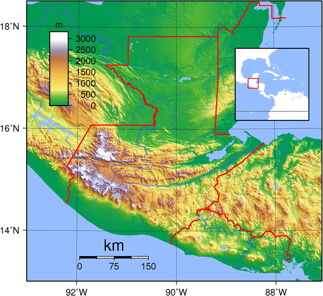
Topographic map of Guatemala.
Petén Lowlands
The Petén region is a large, low-lying basin in northern Guatemala. It occupies a portion of the Yucatán Peninsula, a limestone platform shared with Mexico and Belize. The region constitutes more than one-third of the country's territory. In the Petén, a dense rainforest is interspersed with patches of savanna grasslands. Few rivers exist, as most of the rainfall drains underground.
Guatemalan Highlands
An upland region known as the Guatemalan Highlands lies between the highly volcanic Sierra Madre de Chiapas to the south and the Petén lowlands to the north. This region comprises a series of high valleys enclosed by mountains. The highest slopes of the Sierras are forested with oak and pine. However, stands of pine, fir, and oak have been largely destroyed throughout these volcanic highlands.
The northern chain of mountains is known as the Sierra de Los Cuchumatanes, Guatemala's and Central America's highest mountain chain. It stretches eastward, becoming known as the Sierra de Chama and eventually the Sierra del Santa Cruz. The northern and southern mountains are separated by the Motagua Valley, where the Motagua River and its tributaries drain into the Gulf of Honduras. Eighteen significant rivers originate in the highlands region.
From Guatemala City, east toward Honduras, the terrain is primarily dominated by semiarid flatlands covered in cacti. The area to the north of Guatemala City is mainly mountainous and composed of limestone. A unique feature of this area, found in its northern limits, is the presence of small, forested limestone hills. The Sierra de las Minas mountain range runs east-west through the highlands.
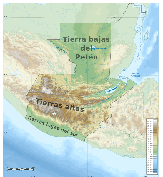
Geographical regions/relief map of Guatemala.
Pacific Coast Flatlands
The Pacific coast flatlands, or southern lowlands, are in the country's south and run roughly parallel to the highlands. From the base of the volcanic row of the highlands, the Pacific coastal plain gradually slopes south to sea level at the ocean shoreline. The plain extends east-west for about 240 km (150 mi) and is one of the country's richest agricultural areas.
The landscape has largely been cleared of its tropical forest and savanna. Instead, this rich agricultural area now hosts vast sugarcane and coffee plantations. Coffee growing is especially prevalent on the slopes of the highland zones as they descend into the coastal plain. Due to its proximity to the country's volcanic chain, the Pacific Coast is also home to wetlands, mangrove swamps, and dark-sand beaches.
Caribbean Coast
Close to the Caribbean coast, in the department of Izabal, the terrain becomes lush and primarily composed of banana plantations. Small mountains are interspersed throughout the Caribbean coastal region. A tiny sliver of the Caribbean coastline runs between the Honduran border and Belize. The area features white-sand beaches, swampland, and tropical rainforests.
Islands
Guatemala's coastline is relatively short, and compared to other coastal nations, it has few islands. Most of its islands are located in Lake Petén Itzá and the Izabal region.
Isla de Flores: This island is located in Lake Petén Itzá near the town of Flores. It's a popular tourist destination and serves as a gateway to the nearby Mayan ruins of Tikal.
Isla San Felipe: Located near Livingston in the Izabal region, this historically significant island was once a Spanish colonial fortification.
Isla de los Pájaros: Translating to "Bird Island," this island is also found in the Río Dulce near Livingston. It's a sanctuary for various bird species.
Isla Parida: This island, located in the Gulf of Honduras, is known for its natural beauty and is part of the Punta de Manabique Wildlife Refuge.
Bodies of Water
Guatemala is known for its diverse and beautiful bodies of water, which play crucial roles in its natural environment, economy, and culture. From stunning lakes nestled between volcanoes to rivers that traverse lush forests and carve canyons, Guatemala's water bodies offer many experiences and opportunities for locals and tourists.
See: Water Bodies of Guatemala
Administrative Divisions
Guatemala is divided into 22 departments. The departments are subdivided into 340 municipalities.
See: Cultural Landscape of Guatemala
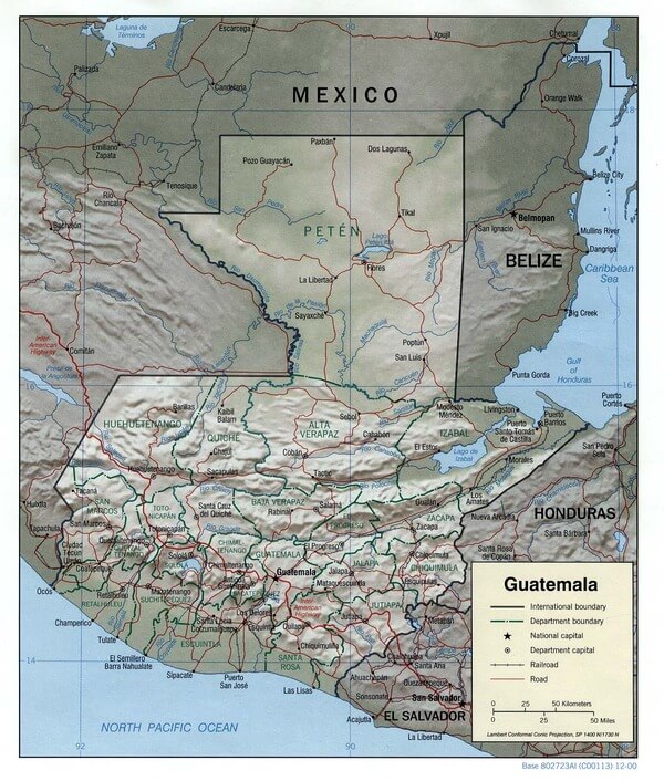
Guatemala relief map
Natural Regions
Biomes
Tropical Humid Forest
This biome is characterized by its poor soil but exuberant jungles and diverse fauna. It is generally defined by a hot and humid climate with no apparent difference between the rainy and dry seasons.
Vegetation includes high- and low-altitude forests, savanna, and wetlands systems. The dominant vegetation type is broad-leaved trees and some pines (Pinus caribea). Representative avifauna include Ocellated Turkey, Yucatan Flycatcher, White-browed Wren, Black-throated Shrike-tanager, and Rose-throated Tanager.
Tropical Rainforest
Although similar to the Humid Tropical Forest, rainfall and humidity are much higher, and the vegetation is more complex. The prevailing climate is hot and humid. Although the dry season of summer is not very defined, more rain can be expected between June and October.
This biome has several ecosystems, including high evergreen forests, savannahs, associated grasslands, mangroves, and estuaries. The dominant vegetation is broadleaf trees, although there are some associations of pines (Pinus caribea and P. oocarpa). The avifauna includes the Orange-breasted Falcon, White-crowned Pigeon, White-collared Manakin, Snowy Cotinga, Gray-headed Tanager, Olive-backed Euphonia, Golden-winged Warbler, and Green-backed Sparrow.
Cloud Forest
Located on mountain slopes, this biome's floristic composition is highly complex. This habitat presents high biodiversity and associated vegetation (avocados, pines, oaks, and tree ferns). The understory comprises various plants and mosses in different strata, conferring a high complexity.
The avifauna includes the Horned Guan, Highland Guan, Resplendent Quetzal, Belted Flycatcher, and Pink-Headed Warbler. The daytime climate is temperate and humid, while nighttime temperatures can be cold. This biome experiences a high level of rain, generally occurring between April and September.
Chaparral or Thorn Dry Scrub
The Chaparral is one of the most fragile biomes, with less representation in the protected areas system. It has a discontinuous distribution through the central-eastern region of the country. It occurs in valleys surrounded by mountains that generate the phenomenon known as a rain shadow, creating dry zones. As a result, vegetation includes abundant cactus and thorn plants.
This biome experiences a short but well-marked rainy season between June to October. The avifauna includes Lesser Ground-cuckoo, Orange-fronted Parakeet, Russet-crowned Motmot, Turquoise-browed Motmot, Cinnamon Hummingbird, White-lored Gnatcatcher and Altamira Oriole.
Mountain Forest
Here, the influence of the North American region is evident in its biodiversity. In addition, the climate is usually cold, and the seasons are related to northern latitudes. The biome has few species, with only one stratum differentiated and a very poor forest understory. However, several endemic plants and fauna can be found in this biome, which occupies the central highlands. The avifauna includes the White-breasted Hawk, Golden-cheeked Warbler, Goldsman's Warbler, Pine Siskin, and Guatemalan Junco.
Tropical Humid Savannah
This biome is located along the Pacific Coast and experiences predominantly warm weather. The original vegetation (deciduous forest, evergreen forest, savannas, and mangroves) has been transformed and replaced by agricultural landscapes, although remnants of the original vegetation remain in some areas. The avifauna includes the Common Black-Hawk, White-bellied Chachalaca, Pacific Parakeet, Violet Sabrewing, and Long-tailed Manakin.
Subtropical Humid Forest
This biome is located in the Pacific region and runs through the slopes of the volcanic chain. Vegetation is diverse. Temperatures are moderately warm, and the volcanic chain serves as a wind barrier for the humid winds that come from the south. However, this biome experiences a high amount of precipitation. The avifauna includes the Red-throated Parakeet, Blue-tailed Hummingbird, Azure-rumped Tanager, and Prevost's Ground Sparrow.
Ecological Regions
The following is a list of terrestrial ecoregions in Guatemala, as defined by the World Wide Fund for Nature (WWF). Guatemala is in the neotropical realm. Ecoregions are classified by biome type—the major global plant communities determined by rainfall and climate.
Tropical and subtropical moist broadleaf forests
Central American Atlantic moist forests
Central American montane forests
Chiapas montane forests
Petén-Veracruz moist forests
Tropical and subtropical dry broadleaf forests
Chiapas Depression dry forests
Tropical and subtropical coniferous forests
Central American pine–oak forests
Deserts and xeric shrublands
Motagua Valley thorn scrub
Mangroves
Belizean Coast mangroves
Northern Honduras mangroves
Northern Dry Pacific Coast mangroves
Regions map of Guatemala.