Argentina: Natural Landscape
Argentina is the second largest country in South America after Brazil and the eighth largest country globally. With the Andes forming its western border with Chile, the country's varied geography can be grouped into five geographic regions or sectors and seven natural regions or ecosystems.
 https://www.flickr.com/photos/doug88888/5909721491/in/album-72157622863048370/")


 https://www.flickr.com/photos/39997856@N03/8634156944")


 https://www.flickr.com/photos/seeminglee/38376149636")
The Natural Landscape of Argentina
Argentina is located in the heart of the Southern Cone of South America and has a wide range of geographical diversity and beauty. Its southern and western borders are shared with Chile, while Bolivia and Paraguay mark its northern boundaries. To the east, Argentina shares borders with southern Brazil and Uruguay, and the Atlantic Ocean completes its eastern limits.
The western expanse of Argentina is defined by the awe-inspiring Andes Mountains, which stretch majestically over 5,300 kilometers (3,300 miles). These mountains represent the longest international border on the South American continent and form the natural barrier between Argentina and Chile. This mountainous region is punctuated by towering peaks, including the iconic Aconcagua, the highest summit in the Americas. The Andes provide a striking backdrop to the landscape and contribute to creating diverse ecosystems, climates, and natural wonders.
On the opposite side, to the east, Argentina showcases a sprawling Atlantic coastline that extends approximately 4,700 kilometers (2,900 miles). This extensive coastal stretch is marked by a dynamic interplay of ecosystems, ranging from serene beaches to vibrant estuaries and wetlands.
As the second-largest country in South America, Argentina holds the eighth position globally, following closely behind Brazil. This vast expanse allows for remarkable topography, encompassing four distinct geographic regions and seven natural ecosystems. These diverse landscapes contribute to Argentina's status as a country of immense ecological and climatic variety, making it a haven for unique flora and fauna.
The primary geographic regions include the Andes Mountains in the west, the Pampas in the central area, the northern deserts and plateaus, and the southern Patagonian steppes and Tierra del Fuego. Each region has distinct characteristics, from the fertile plains of the Pampas, ideal for agriculture and ranching, to the rugged beauty of Patagonia, known for its glaciers, mountains, and expansive plateaus.
Argentina's natural ecosystems further enhance its ecological significance. These ecosystems range from the Andean deserts and forests to the wetlands of the Paraná Delta, each supporting a unique array of plant and animal life. The country's commitment to conservation is evident in UNESCO World Heritage sites such as the Quebrada de Humahuaca and the Valdés Peninsula, where breathtaking landscapes and cultural and ecological treasures are preserved.
Biodiversity
Argentina is a remarkable haven of biodiversity, boasting an impressive array of plant and animal species that contribute to its global standing in the realm of natural wealth. According to the Global Biodiversity Index, Argentina holds the 21st position worldwide, attesting to the richness of its ecosystems. The country's diverse landscapes, ranging from the towering Andes Mountains to the lush Patagonian steppe and the subtropical jungles of Mesopotamia, provide a mosaic of habitats that foster an extraordinary variety of life.
Argentina is home to an astonishing 1,001 bird species in the avian realm, a testament to the country's diverse environments. The Andes Mountains, with their high-altitude habitats, host unique birdlife adapted to these challenging conditions, while the wetlands and coastal areas provide a haven for various waterfowl and seabirds.
The amphibian and reptile populations further underscore Argentina's biodiversity, with 174 amphibian species and 462 reptile species adding to the ecological mosaic. From the vibrant toad species inhabiting the northern rainforests to the iconic reptiles adapted to the arid climates of the deserts of the north, Argentina's diverse ecosystems offer a home for these fascinating creatures.
The country's freshwater and marine aquatic realms contribute significantly to its biodiversity. Argentina boasts 1,026 fish species, reflecting the abundance of water bodies, from the mountain streams in the Andes to the vast estuaries along the Atlantic coast. The coastal waters, influenced by the cold currents of the South Atlantic, provide an ideal environment for diverse marine life, contributing to the richness of the aquatic ecosystems.
With 390 species, mammals find niches in Argentina's varied landscapes. From the iconic guanaco roaming the Andean plateaus to the elusive puma inhabiting the Patagonian wilderness, each region supports a unique assemblage of mammals adapted to their specific environments. The diversity of landscapes, from dense forests to open grasslands, ensures that a wide range of mammalian species thrive throughout the country.
The staggering number of vascular plants, totaling 10,221 species, reflects Argentina's botanical richness. This diversity is intricately linked to the various ecosystems, from the lush rainforests of the Mesopotamian region to the hardy vegetation of the high-altitude Andean slopes. The endemic plant species found in these distinct habitats contribute to the overall uniqueness of Argentina's flora.
In essence, Argentina's biodiversity is a living testament to the intricate interplay between its landscapes and the myriad life forms that call it home. The country's commitment to conservation and its diverse geography have created a haven for an astounding variety of plant and animal species, making Argentina a treasure trove for biodiversity enthusiasts and researchers.
Conservation Efforts
Argentina is at the forefront of a vital and intricate campaign to safeguard its abundant biodiversity, pristine landscapes, and cultural treasures. Renowned for its breathtaking and varied ecosystems, encompassing tropical rainforests, expansive grasslands, vital wetlands, arid deserts, and the southern extents of the Andes Mountains, the country faces multifaceted challenges in conservation.
The preservation endeavors in Argentina grapple with issues such as habitat fragmentation, illicit wildlife trafficking, the impacts of climate change, and conflicts arising from land use disputes.
Addressing these challenges requires a comprehensive approach that intertwines governmental policies, the concerted efforts of non-governmental organizations (NGOs), and collaborative ventures on an international scale. Together, these diverse conservation initiatives and strategies work to ensure the longevity of Argentina's natural wonders and the sustainability of its unique cultural heritage.
Climate
Argentina's expansive territory and location in the Southern Hemisphere contribute to a remarkable and diverse climate spanning subtropical conditions in the north to subantarctic influences in the far south. Between these climatic extremes lies the Pampas region, characterized by a mild and humid climate.
Argentina's topography gives rise to numerous microclimates, fostering distinct and sometimes contrasting weather patterns across various areas. This climatic diversity adds an extra layer to Argentina's geographical richness, creating a rainbow of atmospheric conditions that intricately shape its landscapes and ecosystems.
Rain Shadow Effect
The Andes Mountains, a formidable natural barrier, profoundly influence Argentina's climatic dynamics, creating a remarkable interplay that significantly shapes temperature patterns and precipitation distribution across the country. This geological feature acts as a climatic gatekeeper, pivotal in shielding the central and northern regions from the full impact of polar winds that would otherwise sweep southward.
The Andes, stretching along Argentina's western border, obstruct the southward flow of cold air masses, protecting against the harsh conditions of polar winds. This shielding effect results in milder temperatures in Argentina's central and northern regions, fostering more temperate and subtropical climates. In this capacity, the Andes are a crucial component in the country's climatic mosaic, influencing the overall thermal profile experienced in these areas.
Beyond serving as a climatic barrier, the Andes induce a meteorological phenomenon known as the rain shadow effect. As prevailing winds carrying moisture-laden air masses encounter the towering peaks of the Andes, they are compelled to ascend. This ascent causes the air to cool rapidly, leading to the condensation and release of precipitation on the windward side of the mountain range. The windward side, typically facing west, receives ample rainfall and supports lush vegetation and ecosystems.
However, a contrasting picture emerges as the now-drier air descends on the leeward side of the Andes—facing away from the prevailing winds. The rain shadow effect creates a region of reduced precipitation, contributing significantly to the aridity experienced in certain western zones of Argentina. This phenomenon occurs because the ascending air on the windward side releases much of its moisture as rainfall, leaving the air dry and descending on the leeward side. The Andes' obstructive influence and descending dry air create conditions conducive to dry climates, shaping the landscape into arid and semi-arid zones.
This intricate dance between the Andes Mountains and atmospheric dynamics establishes a fascinating climatic dichotomy within Argentina. The rain shadow effect, in particular, transforms the western landscapes, forming unique ecosystems adapted to arid conditions. As both a climatic shield and a generator of meteorological phenomena, the Andes Mountains are a defining force in Argentina's climatic richness, illustrating the profound impact of geography on a region's weather patterns and ecosystems.
Humboldt Current
The Atlantic Ocean, particularly the Humboldt Current, further contributes to Argentina's climate's complexity. Originating in the Antarctic region, the Humboldt Current flows northward along the western coast of South America. While residing in the Pacific Ocean, this current notably impacts Argentina's climate by influencing oceanic and atmospheric conditions.
The Humboldt Current serves a dual purpose: moderating temperatures and providing moisture. Its role in maintaining cooler temperatures contributes to Argentina's broader climate. Simultaneously, the moisture contribution substantially shapes rainfall patterns, particularly in the country's eastern regions. The intricate interplay of these oceanic factors is a crucial driver behind the diverse climate observed in Argentina.
Climate Zones
Argentina's climate is a product of a delicate dance between geographical features and atmospheric dynamics, resulting in a diverse and captivating array of weather patterns across the country. Four primary climate zones define Argentina's meteorological diversity.
Subtropical Zone
The subtropical zone in the north and northeast is characterized by hot, humid summers and mild, dry winters. Average temperatures range from 25 - 35 °C (77 - 95 °F) in the summer and 15 - 25 °C (59 - 77 °F) in the winter.
Temperate Zone
The temperate zone, found in the central and southern regions, is characterized by warm, humid summers and cool, wet winters. Average temperatures range from 20 - 25 °C (68 - 77 °F) in the summer and 5 - 10 °C (41 - 50 °F) in the winter.
Arid Zone
The arid zone is located in the west and is characterized by low rainfall and high temperatures. Average temperatures range from 25 - 35 °C (77 - 95 °F) in the summer and 10 - 20 °C (50 - 68 °F) in the winter.
Cold Zone
Cold temperatures and high winds characterize the far south characterize the far south. Average temperatures range from 5 - 10 °C (41 - 50 °F) in the summer and drop below freezing in the winter.
Volcanism
Argentina is one of the world's most geologically dynamic countries, showcasing a notable presence of over 30 active volcanoes. Heightened volcanic activity is intricately linked to the country's geographical positioning, situated atop the Nazca Plate, subducting beneath the South American Plate. The subduction process generates magma that has the potential to ascend to the surface, resulting in eruptions that contribute to Argentina's active volcanic landscape.
Most of Argentina's volcanoes are located in the imposing Andes Mountains, which align with its western border. This concentration is particularly prominent in the central and northern regions of the Argentine Andes, where the tectonic forces are at play, fostering an environment conducive to volcanic activity.
However, this active volcanic landscape is not without its challenges. The potential hazards of volcanic eruptions pose significant threats to Argentina's population and infrastructure. Eruptions can give rise to various dangers, including ashfalls that can impact air quality, lava flows that may endanger nearby communities, pyroclastic flows capable of causing widespread devastation, and lahars (mudflows) that can inundate low-lying areas. These hazards can damage property, agricultural regions, and critical transportation and communication networks.
In response to these potential dangers, the Argentine government has implemented proactive measures to mitigate risks and enhance the country's resilience to volcanic activity. These include establishing a comprehensive network of volcano monitoring stations strategically positioned across the volcanic regions. These monitoring stations are crucial in detecting early signs of volcanic unrest, allowing for timely warnings and evacuation measures to safeguard nearby communities.
Emergency response plans have been formulated for areas near active volcanoes, outlining coordinated efforts to ensure the population's safety during eruptions. Additionally, the government strongly emphasizes public education initiatives to raise awareness about volcano-related risks and disseminate information on safety measures. These efforts contribute to an informed and prepared public, minimizing the potential impact of volcanic hazards.
Despite the challenges of volcanic activity, Argentina's volcanism also presents an opportunity for sustainable energy development. The geothermal potential inherent in volcanic regions has prompted the Argentine government to pursue the active utilization of geothermal resources. By harnessing the natural heat generated beneath the Earth's surface, Argentina aims to reduce its dependence on fossil fuels and promote sustainable energy alternatives. This dual perspective—addressing the risks while harnessing the potential benefits—underscores Argentina's commitment to balancing the dynamic forces of nature with the pursuit of a sustainable and resilient future.
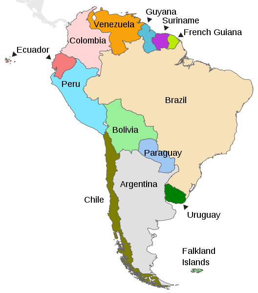
Map depicting the countries on the continent of South America.
Natural Geography of Argentina
Argentina's vast and diverse natural geography unfolds across a spectrum of climatic zones, stretching from tropical latitudes to subantarctic regions. This expansive territory encapsulates rich landscapes, from towering mountain ranges to vast plains, lush rainforests, and arid deserts, each region marked by its distinct characteristics.
West: Andes Mountains
The western region of Argentina is dominated by the majestic Andes Mountains, which showcase the country's highest elevations. This imposing mountain range primarily features arid conditions, creating an awe-inspiring landscape of rugged peaks and high-altitude plateaus. The Andes are crucial in influencing Argentina's overall climate, shaping weather patterns and contributing to the country's climatic diversity.
North: Puna Plateau and Chaco Plains
Moving towards the north, the Puna plateau in the northwest rises to elevated heights and experiences an arid climate characterized by cold temperatures. This region, with its stark landscapes, contributes to Argentina's overall geographical diversity of Argentina. Further to the north-central area, the Chaco plains unfold, featuring a dry subtropical climate. These plains are known for their unique ecosystem and serve as a transition zone between arid and humid environments.
Northeast: Mesopotamia
Mesopotamia, situated in the northeast and encompassing the Missionary Jungle, presents a contrasting landscape with a humid subtropical climate. This region's lush rainforests and vibrant biodiversity add a layer of ecological richness to Argentina's diverse geography. Mesopotamia is a testament to the country's ability to host varied ecosystems within its borders.
Central: Cuyo, Sierras Pampeanas, and Pampas Plains
Moving towards the central region, Cuyo in the midwest unfolds as a semi-arid expanse marked by a temperate climate. With its unique topography, this area showcases a delicate balance between arid conditions and moderate temperatures. The Sierras Pampeanas, or Central Sierras, form a mountainous chain rising sharply from the surrounding Pampas region. This elevation shift creates a dynamic transition from plains to mountains, contributing to the overall geographical diversity of central Argentina.
The Pampas lowland plains in the central and central-east represent a significant portion of Argentina's landscape. These plains are semi-arid in the western limits and humid in the east, creating a mild climate. The Pampas are renowned for their fertile soils, supporting extensive agriculture and ranching activities.
South: Patagonia
Patagonia is a vast and captivating landscape in the southern region characterized by dry and cold conditions. This region's unique geological formations, expansive plateaus, and coastal wonders contribute to Argentina's diverse natural geography. Patagonia is a testament to the country's ability to encapsulate a range of climates and ecosystems within its extensive boundaries.
In summary, Argentina's geographic regions offer a breathtaking array of landscapes, from the arid heights of the Andes to the lush rainforests of Mesopotamia and the expansive plains of the Pampas. This diversity shapes the country's climate and fosters unique ecosystems, showcasing the natural wonders that define Argentina's unparalleled geographical richness.
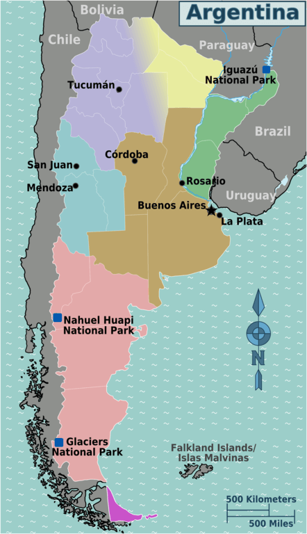
Map depicting the geographical regions of Argentina
Natural Regions
Argentina's natural geography unfolds across seven distinct and captivating natural regions, each contributing to the country's unparalleled ecological diversity, characterized by varied climates, landscapes, and ecosystems. Argentina's natural areas weave together a complex and enthralling collage of environments, reflecting its commitment to preserving and showcasing its ecological diversity.
Andes
The formidable Andes Mountains extend along Argentina's western edge, forming most of the boundary with Chile. This towering mountain range is subdivided into the Fuegian Andes and the Patagonian Andes. While the highest elevations, including Mount Aconcagua, grace the north-central part, the Andes generally present arid conditions, except in the eastern sector, where mountain jungles thrive, and in Patagonia, where a cold rainforest prevails. Provinces embraced by the Andes region include Mendoza, San Juan, La Rioja, Catamarca, and Salta.
Notable protected areas within the Andes natural region include the Aconcagua Provincial Park and the Lihué Calel National Park. Provinces within the Andes region, such as Mendoza, San Juan, La Rioja, Catamarca, and Salta, host various conservation areas.
Puna
The northern sector introduces the Puna plateau, a high, dry, and cold region situated in the rain shadow of the central Andes. This high-elevation grassland biome, existing above the tree line but below the permanent snow line, spans the provinces of Jujuy, Salta, Catamarca, La Rioja, and San Juan. Puna grasslands, existing at 3,000 - 5,000 m (9,850 - 16,400 ft), add to Argentina's geographical diversity.
Protected areas such as Los Cardones National Park and Baritú National Park help preserve the unique Puna grasslands and high-elevation ecosystems.
Chaco
The Chaco region, occupying the country's north between the Andes and the Paraná River, is characterized by flat, fertile plains adorned with dense subtropical forests and savannah grasslands. Subject to a subtropical climate with hot summers and mild winters, the Chaco region spans the provinces of Chaco and Formosa. It potentially includes parts of Santiago del Estero, Salta, and Jujuy.
Protected areas like the Impenetrable National Park and the Río Pilcomayo National Park play a crucial role in conserving the Chaco's biodiversity.
Mesopotamia
Mesopotamia, nestled in the northeastern corner and defined by the Paraná and Uruguay river basins, showcases the lush Missionary Jungle and the Iberá Wetlands. Comprising the provinces of Misiones, Entre Rios, and Corrientes, Mesopotamia boasts a subtropical climate without a dry season, contributing to Argentina's ecological diversity.
Protected areas like the Iguazú National Park and the El Palmar National Park contribute to the conservation of this subtropical region.
Cuyo
Cuyo, situated in central-west Argentina, is renowned for its historical role as a wine-producing region. This semi-arid region receives minimal rainfall and features the Sierras Pampeanas, a mountainous chain rising sharply from the adjacent Pampas region. Comprising the provinces of San Juan, Mendoza, and San Luis, Cuyo represents a unique intersection of climate, geography, and viticulture.
This region has protected areas like the Ischigualasto Provincial Park, the Quebrada del Condorito National Park, and the Talampaya National Park, preserving its semi-arid woodlands and unique geological formations.
Pampas
The Pampas plains, stretching across the country's east-central part, are highly degraded grasslands with a temperate climate. Divided into the arid Dry Pampa and the humid Humid Pampa, these plains are extensively utilized for agriculture and cattle ranching. Provinces encompassed by the Pampas region include Buenos Aires, Córdoba, Santa Fe, Entre Ríos, and La Pampa.
Patagonia
The vast Patagonian plateau covers the region from the Pampas to Tierra del Fuego in the southern expanse. Characterized by steppes, this diverse landscape incorporates the Andes Mountains, glaciers, lakes, forests, grasslands, and deserts. The climate is generally dry and windy, with cold temperatures prevailing throughout the year. The provinces of Neuquén, Río Negro, Chubut, Santa Cruz, and Tierra del Fuego collectively shape the extraordinary geographical mosaic that is Patagonia, covering approximately one-third of Argentina's total land area.
Protected areas like the Nahuel Huapi National Park, Los Glaciares National Park, and Monte León National Park safeguard Patagonia's diverse landscapes.
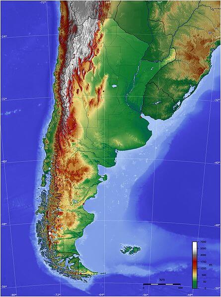
Topographical map of Argentina.
Ecological Regions
Argentina's ecoregions encompass a rich mosaic of diverse ecosystems, ranging from expansive grasslands to lush rainforests and high-altitude deserts. These distinct biogeographic regions showcase the country's ecological wealth, contributing to its status as one of the world's most biodiverse nations.
The following is a list of terrestrial ecoregions in Argentina, as defined by the World Wide Fund for Nature (WWF). Argentina is in the neotropical realm. Ecoregions are classified by biome type, and rainfall and climate determine the major global plant communities.
Temperate broadleaf and mixed forests
Temperate grasslands, savannas, and shrublands
Tropical and subtropical dry broadleaf forests
Montane grasslands and shrublands
Tropical and subtropical grasslands, savannas, and shrublands
Córdoba montane savanna
Tropical and subtropical moist broadleaf forests
Flooded grasslands and savannas
Southern Cone Mesopotamian savanna
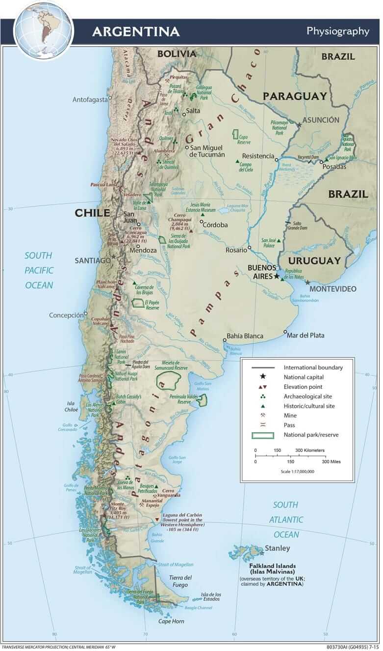
Argentina physiographic map.
Mountain Ranges
Argentina is a vast country with a diverse geography, home to several mountain ranges across different regions. From the towering peaks of the Andes Mountains to the picturesque hills of the Sierra de la Ventana, Argentina's mountains provide a diverse range of experiences for travelers and outdoor enthusiasts.
See more: Mountain Ranges of Argentina
Islands and Archipelagos
Argentina is a vast and diverse country with a long coastline along the Atlantic Ocean. While it's not typically associated with islands in the same way as some other countries, several notable islands and archipelagos are worth mentioning. The country's geography offers diverse island landscapes with unique characteristics and cultural significance.
See more: Islands and Archipelagos of Argentina
Bodies of Water
Argentina boasts diverse water bodies across its vast landscape. The country borders the Atlantic Ocean to the east, providing extensive coastlines and beautiful beaches. Additionally, Argentina is home to the extraordinary Iguazú Falls, a spectacular network of waterfalls on the border with Brazil.
The Paraná River and its tributaries, such as the Paraguay and Uruguay rivers, traverse the country, offering opportunities for river cruises and water-based activities. In the west, the Andes Mountains give rise to pristine lakes, including Nahuel Huapi and Lake Argentino, renowned for their stunning beauty and recreational possibilities.
See more: Water Bodies of Argentina
Administrative Divisions
Argentina is administratively divided into 23 provinces and one autonomous city, Buenos Aires. Each region has its own government structure and autonomy, collectively shaping the country's political and administrative landscape.
See more: Cultural Landscape of Argentina