
The Paraná River: South America’s Great Waterway of Dams, Wetlands, and Grain
The Paraná River runs about 4,880 km through Brazil, Paraguay, and Argentina, draining a basin of roughly 2.6 million km² before it spreads into a 14,000 km² delta on the Río de la Plata. Dams such as Itaipú, a busy grain waterway, and recurring droughts shape life along a river that supplies power, food exports, and drinking water.


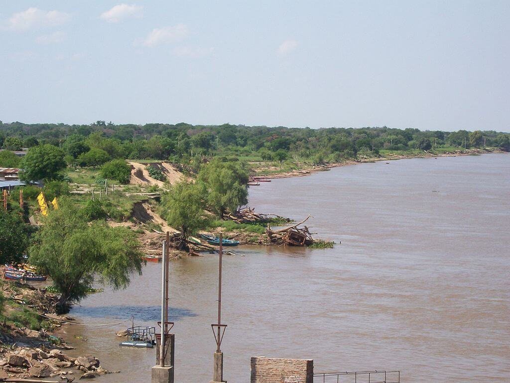
The Paraná River and Delta: From the Brazilian Highlands to the Río de la Plata
The Paraná is the second-longest river in South America, after the Amazon, and the main artery of the Río de la Plata system. It gathers water from the highlands of central and southern Brazil, crosses Paraguay's eastern border, runs the length of northeastern Argentina, and ends in a 320-kilometer (199-mile) delta of islands and marshes that opens into the Río de la Plata. Along the way, it powers cities, carries much of the region's grain to the sea, and supports some of the continent's largest freshwater wetlands.
Source and Course
The river begins in southeastern Brazil at the meeting of two rivers, the Paranaíba and the Rio Grande. The Paraná proper, from that confluence to its mouth, runs about 2,546 kilometers (1,582 miles). The figure usually quoted, 4,880 kilometers (3,032 miles), measures the longer path that follows the Rio Grande from its headwaters in Minas Gerais and continues through the Río de la Plata, so it is better understood as the length of the whole river system than of the Paraná alone. The Paranaíba rises at about 1,148 meters (3,766 feet) in the highlands of Minas Gerais.
Below the confluence, the river flows through Brazil's most densely developed interior, receiving the Tietê, the Paranapanema, and other tributaries that drain the metropolitan region of São Paulo. It then turns south and forms the border between Brazil and Paraguay for roughly 200 kilometers (124 miles), until it meets the Iguazu River near the triple frontier of Brazil, Paraguay, and Argentina. From there, the Paraná becomes the border between Paraguay and Argentina. Cities face each other across the water, and a bridge links Posadas, Argentina, to Encarnación, Paraguay. North of Corrientes, the river receives the Paraguay River, which brings water from the Pantanal, and then runs south for about 820 kilometers (510 miles) through Argentina, past Santa Fe and Rosario, before the delta begins.
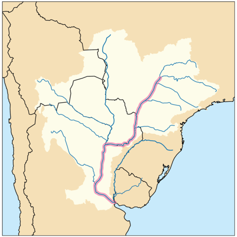
Map depicting the location of the Paraná River.
The Basin
The Paraná drains about 2.6 million square kilometers (1 million square miles), though sources differ. Figures range from about 2.58 million to 2.63 million km² depending on how the Paraguay basin and the lower river are counted, and some popular sources round up to 2.8 million km². The basin covers most of southern and central Brazil, nearly all of Paraguay, northern Argentina, and part of Bolivia, and if the Uruguay River is added as part of the same system, it reaches most of Uruguay as well. Average discharge at the delta is about 17,000 to 20,000 cubic meters per second (600,000 to 700,000 cubic feet per second), depending on the period measured, and the flow swings widely between wet and dry years.
Dams and Hydropower
The upper river has been heavily dammed. The best-known project is Itaipú, built jointly by Brazil and Paraguay on the border. Its 20 generating units of 700 megawatts each give it an installed capacity of 14,000 megawatts, and its dam rises 196 meters (643 feet) behind a reservoir about 170 kilometers (106 miles) long. According to Itaipú Binacional, the plant supplies about 90 percent of Paraguay's electricity and roughly 10 percent of Brazil's. Construction in the 1970s displaced an estimated 10,000 families who lived beside the river. Farther downstream, the Yacyretá dam is shared by Argentina and Paraguay. Together with dozens of smaller reservoirs on the Paraná and its tributaries, these dams trap sediment, change flood timing, and interrupt fish migration.
The Paraná Delta
Downstream of Diamante, in Entre Ríos Province, the river leaves its main channel and breaks into a web of branches, islands, lagoons, and marshes. The delta is about 320 kilometers (199 miles) long and between 18 and 60 kilometers (11 and 37 miles) wide, covering about 14,000 km² (5,400 square miles). It is conventionally divided into upper, middle, and lower sections, and its main arms include the Paraná Pavón, Paraná Ibicuy, Paraná de las Palmas, Paraná Guazú, Paraná Bravo, and Paraná Miní. The river carries an estimated 160 million tonnes of sediment a year, and the delta front continues to advance into the Río de la Plata. Most of the delta lies in Entre Ríos, and the rest lies in northern Buenos Aires Province.
The delta floods in pulses that follow the river's rise and fall, and plants and animals have adapted to that rhythm. The islands behave like shallow bowls, with higher banks and a lower, wetter center, where marshes form and store floodwater. That role matters to downstream cities, because the wetlands soak up high water and filter the river before it reaches Buenos Aires.
Wildlife and Protected Areas
The delta shelters the marsh deer (Blastocerus dichotomus), the capybara (Hydrochoerus hydrochaeris), the neotropical river otter (Lontra longicaudis), the coypu (Myocastor coypus), and the Pampas cat (Leopardus colocola), and the river itself supports large migratory fish such as the sábalo (Prochilodus lineatus) and the dorado (Salminus brasiliensis), which sustain commercial and sport fisheries. At this latitude, plants and animals of the Amazon, the Chaco, and the Pampas meet and mix, which is why the delta is rich in species even though it is far from the tropics.
Several areas are protected. The Delta del Paraná Biosphere Reserve, declared by UNESCO in 2000, covers 886 km² (342 square miles) in the islands north of Buenos Aires, with a 106 km² (41 square miles) core area. Predelta National Park, created on January 13, 1992, protects 24.58 km² (9.49 square miles) of the upper delta just south of Diamante. In 2015, Argentina designated the Delta del Paraná as a Ramsar wetland of international importance.

Aerial view of the Lower Paraná Delta.
A Working Waterway
The Paraná and Paraguay rivers together form the Paraguay-Paraná Waterway (Hidrovía), a river corridor that crosses five countries. The lower stretch, called the Vía Navegable Troncal, carries about 80 percent of Argentina's grain exports, mostly soybean meal and oil, from the port complex around Rosario to the ocean. Landlocked Paraguay depends on the same corridor for much of its trade. In June 2026, Argentina awarded a 25-year concession to dredge, mark, and maintain the channel to the Belgian firm Jan De Nul and its Argentine partner Servimagnus, after an earlier tender was annulled in February 2025. The plan calls for deepening the channel to 12.19 meters (40 feet) as far as Timbúes, north of Rosario, and to 11.89 meters (39 feet) in the Río de la Plata.
Drought, Floods, and Pressure on the Delta
The river's level changes sharply from year to year. A drought that began in 2019 pushed the Paraná to its lowest level in 77 years, and in July 2026 Paraguayan authorities described extreme low water that had cut navigation on the stretch between Yacyretá and the Paraguay River. Itaipú has opened a floodgate at times to help vessels pass. By mid-October 2026, rising water on the Paraná and Uruguay rivers had ranchers in Corrientes moving cattle off the islands. Such swings make planning difficult for shippers, farmers, and island residents alike.
The delta faces added pressure from dredging, diking, and development. Environmental groups say that dredging has proceeded without updated environmental studies, and a 2025 estimate cited by Mongabay Latam put the share of delta wetlands enclosed by embankments at 14 percent, built mainly for cattle, forestry, and housing. Embankments reduce the wetlands' ability to store floodwater, raising flood risk for nearby cities. Specialists have also pointed out that the river is Argentina's largest source of drinking water, supplying around 14 million people.
The Paraná Today
The Paraná links energy, agriculture, and ecology in one river system. Decisions about dams in Brazil, dredging in Argentina, and wetland protection in the delta all affect the same water flow. How well the three countries coordinate on that flow, especially in drought years, will largely determine how long the river can serve as both a working waterway and a living wetland.