Ecuador: Natural Landscape
Ecuador encompasses a wide range of natural landscapes and climates, from the arid Pacific lowland coast to the snowcapped peaks of the Andes to the eastern tropical lowland plains of Amazonia. It also includes the Galápagos Islands off the country's western coast in the Pacific Ocean.

 https://www.flickr.com/photos/bentavener/7165491786")


 https://www.flickr.com/photos/25222005@N08/3213878935")

 https://www.flickr.com/photos/franzleonardo/5934877768")
, https://www.flickr.com/photos/cimmyt/5958075117")
 (distributed via imaggeo.egu.eu)")
")
 via Wikimedia Commons")
The Natural Landscape of Ecuador
Situated on the western coast of South America, Ecuador is a nation rich in geographic diversity, encompassing 2,267 kilometers (1,390 miles) of Pacific coastline. Bordered by Colombia to the north and Peru to the south and east, Ecuador's landscape is one of contrasts, ranging from the arid Pacific coastal lowlands to the snow-capped peaks of the Andes Mountains and the lush tropical plains of the Amazon Basin.
Adding to Ecuador's natural allure are the Galápagos Islands, an archipelago of volcanic origin situated approximately 965 kilometers (600 miles) off the Pacific coast. These islands, famed for their unique flora and fauna, serve as a living laboratory of evolution and a testament to the power of natural selection.
The Pacific lowlands, with their sandy beaches and diverse coastal ecosystems, harbor a rich array of marine and terrestrial life. The Andes Mountains, stretching majestically through the heart of the country, provide breathtaking scenery and a sanctuary for many plant and animal species. To the east, the Amazon Basin, renowned for its dense rainforests and abundant biodiversity, unveils a world of natural wonders.
Ecuador, a compact nation straddling the equator, epitomizes the awe-inspiring diversity of South America's geography. A symphony of landscapes unfolds within its borders, offering a microcosm of the continent's natural splendor.
Biodiversity
Ecuador is a biodiversity powerhouse, earning its designation as a "megadiverse" nation. Despite its compact size, the country's diverse landscapes, spanning the Amazon Rainforest, towering Andes Mountains, and the iconic Galápagos Islands, contribute to its remarkable ecological richness.
Ranked 9th globally in the Global Biodiversity Index, Ecuador showcases an extraordinary variety of life. Boasting 1,629 bird species, 659 amphibians, 1,111 fish, 392 mammals, 492 reptiles, and a staggering 18,466 vascular plant species, Ecuador is part of an exclusive club of 17 megadiverse countries.
Conservation
Ecuador's dedication to conservation is evident in its extensive network of protected areas, comprising national parks, reserves, and marine protected zones. Notable among these are Yasuní National Park, the biodiverse Cuyabeno Wildlife Reserve, and the protected areas of the iconic Galápagos Islands.
This commitment to conservation is a paramount and ongoing effort to preserve the country's remarkable biodiversity, unique ecosystems, and invaluable natural resources. Establishing these protected areas reflects Ecuador's proactive stance in balancing human development with the imperative to safeguard its natural wonders.
Despite Ecuador's strides in conservation, challenges persist. Deforestation, habitat destruction, and the illegal wildlife trade threaten the delicate balance of ecosystems. Ongoing vigilance against unsustainable development practices is essential to mitigate these challenges.
Ecuador exemplifies the delicate dance between progress and preservation in this dynamic conservation landscape. The nation's commitment to biodiversity shines through its protected areas, echoing a dedication to ensuring that the vibrant ecosystems and unique species that define Ecuador endure for generations.
Climate
Overall, Ecuador has a tropical climate with various microclimates, which vary with altitude and region. The mountain valleys experience a temperate climate year-round, and a humid subtropical climate exists in coastal areas and lowland rainforests. Except for the eastern lowlands, which experience year-round rainfall, the country typically follows a wet and dry season pattern, the timing of which varies across regions.
Ecuador has a diverse climate due to its location on the equator and varied topography. The country can be divided into four main climate regions:
Coastal Lowlands: The coastal lowlands have a tropical climate with warm temperatures and high humidity year-round. Temperatures typically range from 27 - 32 °C (81 - 90 °F). The wet season runs from January to April, and the dry season runs from May to December.
Andes Mountains: The Andes Mountains have a temperate climate with cooler temperatures and lower humidity than the coastal lowlands. Temperatures vary depending on altitude but typically range from 18 - 24 °C (64 - 75 °F). The wet season runs from October to May, and the dry season runs from June to September.
Amazon Rainforest: The Amazon Rainforest has a humid tropical climate with warm temperatures and high humidity year-round. Temperatures typically range from 25 - 30 °C (77 - 86 °F). The wet season runs from October to May, and the dry season runs from June to September.
Galápagos Islands: The Galápagos Islands have a dry climate with warm temperatures year-round. Temperatures typically range from 22 - 28 °C (72 - 82 °F). The wet season runs from January to May, and the dry season runs from June to December.
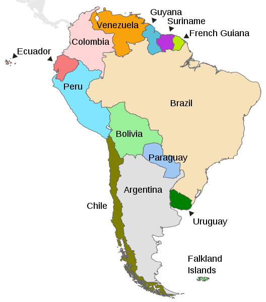
Map depicting the countries on the continent of South America.
Natural Geography of Ecuador
Geographic Regions
Three distinct physical regions contribute to Ecuador's geographical and ecological diversity, offering a range of landscapes and climates within a relatively compact area:
Costa (Coastal Region): The western coastal region, known as the Costa, stretches along the Pacific Ocean. It features lowlands, plains, and coastal ranges with a humid subtropical climate. This region is characterized by lush vegetation and rich biodiversity.
Sierra (Highland Region): The central highland region, or Sierra, is dominated by the Andes Mountains that run through the country from north to south. This area includes numerous valleys and plateaus, diverse ecosystems, and a temperate climate. The Sierra is home to Ecuador's major cities, including Quito.
Oriente (Eastern Region): The eastern region, also called the Oriente or Amazon Basin, encompasses the lowland rainforests of the Amazon Rainforest. Dense jungles, numerous rivers, and a tropical climate characterize it. The Oriente is known for its incredible biodiversity and is home to indigenous communities.
The Galápagos Islands (Archipiélago de Colón), off the country's west coast, can be considered a fourth geographic region.
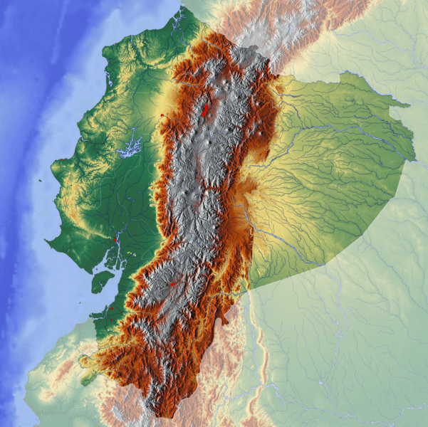
Topographic map of Ecuador.
Coastal Lowlands (La Costa)
Ecuador's coastal lowlands (La Costa) extend eastward from the Pacific Ocean to the western edge of the Andes Mountains. They rise from sea level to approximately 500 m (1,650 ft) in elevation. Small coastal ranges run north and south between the coastal plains and the Andes, forming interior valleys.
Much of the native forest in the Costa has been replaced by agricultural production and cattle ranching. The remaining fragments include dry and wet tropical forests found primarily along the coastal mountain ranges. Collectively known as the Pacific Equatorial Forest, these forest remnants are considered the most endangered tropical forest in the world. They are part of the Tumbes-Choco-Magdalena biodiversity hotspot, which includes Machalilla National Park.
The main watercourse of the coastal lowlands is the Guayas River, formed by the juncture of the Daule and Babahoyo rivers and their effluents. Other rivers that flow toward the Pacific coast include the Cayapas River, the Esmeraldas River, the Naranjal River, the Jubones River, and the Santa Rosa River.
Central Highlands (La Sierra)
The central highlands or Sierra natural region of Ecuador (La Sierra) encompasses the central and western ranges of the Ecuadorian Andes and their respective eastern and western foothills. Many of the mountain peaks are volcanic or snow-covered. Transversal mountain chains connect the two ranges at intervals and feature large, isolated basins known as hoyas. Numerous rivers originate in the mountains and pass through the hoyas either to the Pacific coast in the west or through the eastern lowlands.
Protected areas within the Sierra region include El Cajas National Park, El Cóndor National Park, and Sangay National Park. The city of Quito, Ecuador's capital, is located in a high mountain valley on the foothills of the Pichincha volcano.
Eastern Lowlands (El Oriente)
To the east, beyond the eastern ranges of the central highlands, are the eastern lowlands of Ecuador (El Oriente). Here, tropical, moist, broadleaf forests descend from the eastern slopes into the Amazon Basin. The most important river in the Eastern Lowlands is the Napo River, which receives several large tributaries and makes its way toward Peru, eventually emptying into the Amazon River. Other significant rivers include the Pastaza, Morona, and Santiago, which drain into the Marañón River in Peru.
The Oriente is also home to many of Ecuador's indigenous groups, notably the lowland Quechua, Siona, Secoya, Huaorani, and Cofán. Protected areas within the Oriente region include Yasuní National Park and Podocarpus National Park.
Galápagos Islands
The Galápagos Islands (Archipiélago de Colón) consist of 7,880 sq km (3,040 sq mi) of land spread over 45,000 sq km (17,000 sq mi) of the Pacific Ocean. The archipelago, approximately 965 km (600 mi) west of the coast of Ecuador, consists of 18 main islands, three smaller islands, and numerous rocks and islets. The islands are formed of lava piles and dotted with periodically active volcanoes. The arid landscape is rugged and accentuated by mountains, craters, and cliffs.
The climate of the Galápagos archipelago is characterized by low rainfall, low humidity, and relatively low air and water temperatures. The arid lowlands are covered by an open cactus forest. Thousands of plant and animal species, the vast majority endemic, are found here. The Protected Areas of the Galápagos Islands include Galápagos National Park, Galápagos Marine Reserve, and Galápagos Biosphere Reserve.
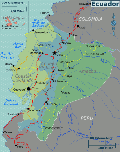
Map depicting the geographic regions of Ecuador.
Mountain Ranges
Ecuador is characterized by its stunning and diverse mountainous regions, which play a central role in shaping its unique geography, climate, and culture. The country's mountainous areas are primarily centered around the Andes, the world's most extended mountain range, which runs from north to south through the heart of Ecuador. However, other mountainous regions add to the country's rich natural beauty and biodiversity.
See more: Mountain Ranges of Ecuador
Islands and Archipelagos
Ecuador has diverse islands offering unique ecosystems, cultures, and experiences. These islands collectively embody Ecuador's diverse ecosystems' natural wonders and cultural significance. The Galápagos Islands, in particular, stand out as a global symbol of conservation and a living laboratory for studying evolutionary biology.
See more: Islands and Archipelagos of Ecuador
Bodies of Water
Ecuador's water bodies are an essential part of the country's natural and cultural heritage. They provide a source of water for drinking, irrigation, and transportation. They are also popular tourist destinations and offer a variety of recreational opportunities.
See more: Water Bodies of Ecuador
Administrative Divisions
Administratively, Ecuador is divided into 24 provinces, each with its own capital, and each province is divided into cantons.
See more: Cultural Landscape of Ecuador
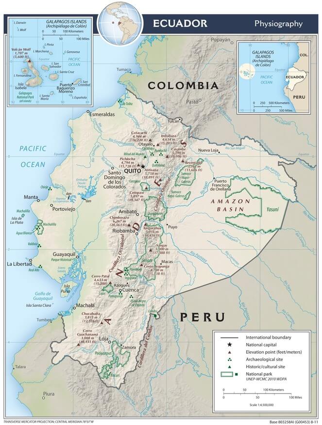
Ecuador physiographic map.
Ecological Regions
The following is a list of terrestrial ecoregions in Ecuador, as defined by the World Wide Fund for Nature (WWF). Ecuador is in the Neotropical realm. Ecoregions are classified by biome type - the major global plant communities determined by rainfall and climate.
Tropical and subtropical moist broadleaf forests
Eastern Cordillera Real montane forests
Northwestern Andean montane forests
Tropical and subtropical dry broadleaf forests
Flooded grasslands and savannas
Guayaquil flooded grasslands
Montane grasslands and shrublands
Mangroves
Gulf of Guayaquil-Tumbes mangroves
Manabí mangroves
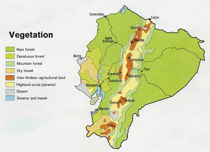
Vegetation map of Ecuador.