Exploring the Ecuadorian Andes: Ecuador's Majestic Andean Highlands
Nestled within the heart of Ecuador, the majestic Andean highlands, known as La Sierra, stand as a breathtaking testament to nature's grandeur. This vast region is a tapestry of towering peaks, deep valleys, and geological wonders that have captivated for centuries.
 https://www.flickr.com/photos/francesco_veronesi/6194603889/")

 https://www.flickr.com/photos/7954439@N06/5598784513")


 via Wikimedia Commons")
Exploring the Ecuadorian Andes: Ecuador's Majestic Andean Highlands
Nestled within the heart of Ecuador, the majestic Andean highlands, known as La Sierra, stand as a breathtaking testament to nature's grandeur. This vast region, spanning approximately 70,000 square kilometers (27,000 square miles), has towering peaks, deep valleys, and an array of geological wonders that have captivated explorers and nature enthusiasts for centuries. Delving into the intricacies of this remarkable landscape uncovers a world of natural splendor, rich cultural heritage, and a tapestry of ecosystems.
Geological Marvels of the Ecuadorian Andes
The Cordilleras: Towering Sentinels of the Andes
At the heart of the Ecuadorian Andes lies a network of parallel mountain ranges known as cordilleras. These imposing cordilleras form the backbone of the Tropical Andes (a climate-delimited region of South America's greater Andes mountain system), running in a slightly curved S-shape from Colombia's northern border to Peru's southern frontier. The subduction of the Nazca Plate beneath the South American Plate has given rise to these remarkable geological formations, sculpting the landscape with a profound intensity.
The Cordillera Occidental, the westernmost range, boasts 19 majestic volcanoes, while the Cordillera Central, located further east, is home to 20 volcanoes, some of which are capped with perpetual snow. A third cordillera, the Cordillera Oriental, has been identified in Ecuador's eastern jungle region, adding to the country's geological diversity.
Volcanic Wonders: Nature's Fiery Spectacle
Among the iconic peaks that adorn the Ecuadorian Andes, several volcanoes stand out as true natural wonders. Chimborazo, an inactive volcanic giant towering 6,267 meters (20,561 feet), is the farthest point from Earth's center due to the planet's equatorial bulge. Cotopaxi, rising to a staggering 5,897 meters (19,347 feet), is the third-highest active volcano in the world, commanding respect and awe from all who gaze upon its majestic form.
The twin volcanic peaks of Illiniza Sur and Illiniza Norte, separated by a saddle approximately 1 kilometer (0.6 miles) long, offer a unique and striking sight. Tungurahua, an active volcano in eruption since 1998, has become a captivating destination for adventurous souls seeking to witness nature's raw power up close in the charming town of Baños-Tunguragua. Finally, the mighty Pichincha, at 4,784 meters (15,696 feet), stands sentinel over the capital city of Quito, constantly reminding the region's geological grandeur.
The Basins and Valleys of La Sierra
Diverse Landscapes and Fertile Basins
La Sierra, Ecuador's central Andean highlands region, is a patchwork of diverse landscapes and fertile basins. Transversal mountain spurs, known as nudos, created by the outpouring of lava from the numerous volcanoes in the range, have divided the region into ten major basins. Among these, the Nudo del Azuay, at an impressive 4,500 meters (14,763 feet), stands as the highest transversal spur, separating the Sierra into two distinct subregions.
To the north, modern volcanism features newer and higher mountains, while the southern region, characterized by ancient volcanism, has eroded over time, resulting in lower elevations. These basins and their adjacent slopes, intensively cultivated, are home to approximately half of Ecuador's population, with cities like Ibarra, Ambato, Riobamba, Mindo, Baños, and Cuenca dotting the landscape.
Quito: A Jewel in the Highlands
Nestled in a high mountain valley at the foothills of the imposing Pichincha volcano lies Quito, Ecuador's captivating capital city. This historic urban center, with its rich colonial architecture and vibrant cultural tapestry, serves as a gateway to the wonders of the Andean highlands. From Quito, adventurers can embark on unforgettable journeys, exploring the region's diverse ecosystems, ancient ruins, and the timeless traditions of the indigenous communities that call this remarkable landscape home.
Notable Mountains and Volcanoes
Peaks that Touch the Sky
The Ecuadorian Andes boast a remarkable collection of towering mountains and volcanoes that have captured the imagination of adventurers and mountaineers for generations. Among these natural wonders, several stand out as truly iconic landmarks:
Chimborazo (6,267 m / 20,561 ft): An inactive volcanic giant, Chimborazo is the furthest point from Earth's center due to the planet's equatorial bulge. This makes it a prized summit for mountaineers seeking a unique challenge.
Cotopaxi (5,897 m / 19,347 ft): Renowned as the third-highest active volcano in the world, Cotopaxi's perfectly symmetrical cone is a sight to behold. Its glaciated summit and occasional eruptions remind visitors of the raw power of nature.
Illiniza Sur (5,245 m / 17,208 ft) and Illiniza Norte (5,126 m / 16,817 ft): These twin volcanic peaks, separated by a narrow saddle, offer a striking visual and a rewarding challenge for experienced mountaineers.
Tungurahua (5,023 m / 16,480 ft): An active volcano that has been erupting since 1998, Tungurahua has become an iconic landmark in Baños-Tunguragua. Visitors can witness the fiery spectacle of nature's fury.
Pichincha (4,784 m / 15,696 ft): Overlooking the capital city of Quito, this majestic volcano is a constant reminder of the region's geological grandeur and is a popular destination for hikers and nature enthusiasts.
These towering peaks, each with unique character and challenges, beckon adventurers worldwide to experience the raw beauty and power of the Ecuadorian Andes.
Conclusion
Ecuador's Andean highlands, known as La Sierra, are a testament to nature's awe-inspiring power and the human spirit's resilience. From the towering volcanic peaks to the fertile basins and valleys that sustain life, this region offers a tapestry of experiences that captivate the senses and nourish the soul. As we explore the geological wonders, diverse landscapes, and cultural richness of La Sierra, we are reminded of our planet's inherent beauty and fragility, inspiring us to cherish and protect these natural treasures for generations to come.
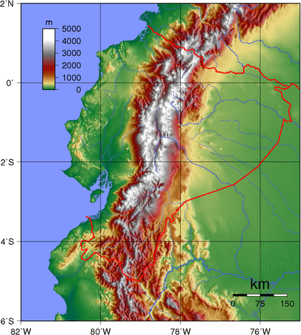
Topographic map of Ecuador.