The Venezuelan Coastal Range: A Barrier of Biodiversity and Culture
Stretching along Venezuela's northern coast, the Venezuelan Coastal Range, known locally as the Cordillera de la Costa, forms a natural boundary between the Caribbean Sea and the country's northern plains. It is also a region of rich biodiversity, deep cultural history, and significant economic importance.


The Maritime Andes: Venezuela's Natural Barrier and Cultural Crossroads
Stretching along the northern coast of Venezuela, the Venezuelan Coastal Range, known locally as the Cordillera de la Costa, forms a natural boundary between the Caribbean Sea and the northern plains of Venezuela. Extending approximately 1,200 kilometers (750 miles) from the state of Sucre in the east to Zulia in the west, this mountain range is more than just a physical barrier—it is a region of rich biodiversity, deep cultural history, and significant economic importance. The range, sometimes called the Maritime Andes, is a northeastern extension of the Andes Mountains but is a distinct geological formation with unique characteristics.
Geographic Overview
Two Parallel Ranges
The Venezuelan Coastal Range comprises two parallel mountain ranges: the Interior Range (Cordillera de la Costa Interior) and the Caribbean Range (Cordillera de la Costa Caribe). These ranges are separated by valleys and rivers, including the Caracas Valley, which houses Venezuela's capital, Caracas.
The Interior Range, located to the east, is the higher and more rugged of the two. It extends from the state of Sucre to the state of Carabobo. It features some of the highest peaks in the region, such as Pico Turimiquire and Pico Oriental, which reach elevations above 2,000 meters (6,500 feet). This range is characterized by steep slopes, deep valleys, and dense vegetation, making it a significant natural barrier.
The Caribbean Range, situated to the west, stretches from Carabobo to Zulia. This range is lower in elevation than the Interior Range, with gentler slopes and less rugged terrain. However, it still boasts impressive peaks, including Pico Naiguatá, which reaches an elevation of approximately 2,765 meters (9,072 feet).
A Natural Barrier
The Venezuelan Coastal Range is a formidable barrier between the Caribbean Sea and the northern coastal plains. Its steep slopes and rugged terrain have historically limited communication and transportation between the coast and the interior. However, the range's strategic location has also made it a population and economic activity hub. Numerous towns and cities are located along the range's foothills, and it contains Venezuela's greatest concentration of population despite covering only a tiny fraction of the national territory.
Ecological Significance
Diverse Ecosystems
The Venezuelan Coastal Range is renowned for its rich biodiversity and varied ecosystems. The range's slopes are covered with dense tropical rainforests that harbor various plant and animal species, many of which are endemic to the region. This high level of endemism makes the range a critical area for conservation efforts.
At lower elevations, the La Costa xeric shrublands ecoregion dominates, characterized by dry, thorny vegetation adapted to the arid conditions. The Araya and Paria Xeric scrub occupies the drier zones of the Araya and Paria peninsulas. At the same time, the montane areas of the Paria Peninsula are part of the more humid La Costa Xeric shrublands.
As elevation increases, the vegetation transitions into humid evergreen forests. These montane forests, located between 600 and 2,675 meters (1,969 and 8,776 feet) above sea level, are home to a diverse array of species, including many not found anywhere else in the world. The range's diverse ecosystems provide critical habitats for wildlife and play a vital role in regulating the region's climate and water resources.
Human Impact and Cultural Significance
Population Centers
Despite its rugged terrain, the Venezuelan Coastal Range has been a focal point for human settlement and activity for centuries. The range's foothills and valleys are home to some of Venezuela's largest cities, including Caracas, Maracay, Valencia, and Puerto Cabello. These cities are economic and cultural hubs that have played significant roles in the country's history and development.
Caracas, the capital city, is particularly noteworthy for its location at the base of the range, nestled between Cerro El Ávila and the coastal plains. The city's unique position has shaped its development and made it a critical center for commerce, culture, and government in Venezuela.
Historical and Cultural Legacy
The Venezuelan Coastal Range is not only a natural landmark but also a cultural one. The region has been inhabited for thousands of years, with indigenous peoples and later Spanish colonizers leaving their mark on the landscape. The range's valleys and slopes are dotted with historical sites, including colonial-era towns, fortresses, and churches, that reflect the region's rich cultural heritage.
The range's natural beauty and cultural significance have also made it a popular destination for tourism. National parks, such as El Ávila National Park near Caracas, attract visitors with their stunning landscapes, diverse wildlife, and opportunities for outdoor recreation.
Conclusion
The Venezuelan Coastal Range is a testament to Venezuela's natural beauty and cultural richness. Its rugged peaks, dense forests, and diverse ecosystems provide a critical habitat for wildlife and a vital resource for the country's population. The range's historical and cultural significance further enhances its importance as a national treasure. As a natural barrier, a center of biodiversity, and a cultural landmark, the Venezuelan Coastal Range plays a central role in the nation's life.
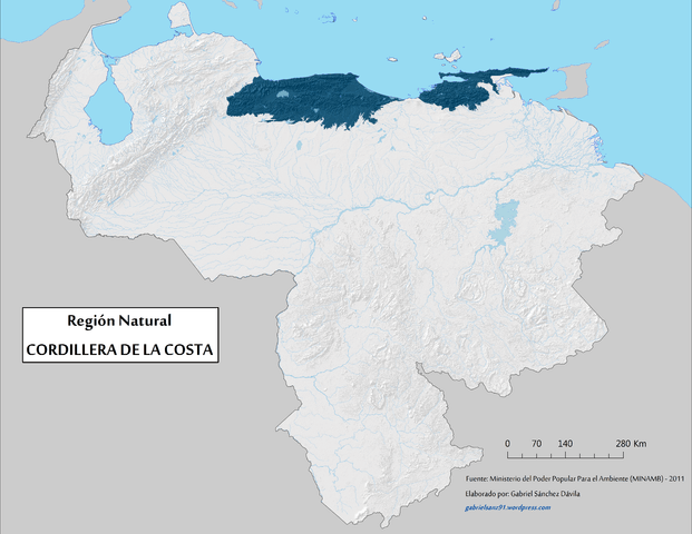
Map depicting the Venezuelan Coastal Range (Cordillera de La Costa) natural region.