
The American Cordillera and the Continental Divide: A Geographical Backbone Shaping the Americas
The Americas' Continental Divide separates watersheds flowing into the Pacific Ocean from those flowing into the Atlantic. It spans North America's northernmost point to South America's southernmost tip and is linked to the creation and evolution of the mountainous American Cordillera.
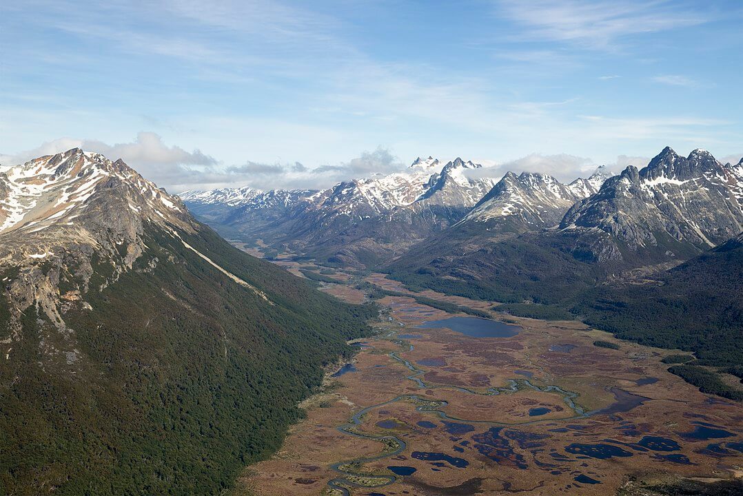
The American Cordillera: One Mountain System, Four Countries' Worth of Names
Few geographical features illustrate the interconnectedness of an entire hemisphere as clearly as the American Cordillera, the nearly unbroken chain of mountains running along the western edge of North, Central, and South America from Alaska to the southern tip of Tierra del Fuego. Stretching more than 20,000 km (12,400 mi), it ranks among the longest mountain systems on Earth, and its segments carry different regional names: the Rocky Mountains, the Sierra Madre, Central America's volcanic highlands, and the Andes, even though they form a single, geologically continuous backbone.
One System, Many Names
In North America, the Cordillera takes the form of the Rocky Mountains, stretching from Alaska and Canada southward through the western United States. In Mexico, it splits into the Sierra Madre system: the Sierra Madre Occidental and Sierra Madre Oriental run roughly parallel down either side of the Mexican Plateau, joined further south by the Sierra Madre de Oaxaca, Sierra Madre del Sur, and Sierra Madre de Chiapas. It is worth noting that the Sierra Madre is distinct from the perpendicular Trans-Mexican Volcanic Belt, a separate volcanic chain that cuts east-west across central Mexico rather than continuing the Cordillera's north-south trend.
The Cordillera continues through Central America as a series of volcanic ranges, including the Cordillera de Guanacaste and Cordillera de Talamanca in Costa Rica, before crossing into South America, where it takes its best-known regional name: the Andes. There, the Cordillera reaches its greatest heights and breadth before narrowing again through Patagonia and finally terminating amid the islands of Tierra del Fuego, where the Andes make their final appearance as the low, glaciated peaks of the Fuegian Andes before disappearing beneath the Strait of Magellan and the Drake Passage.
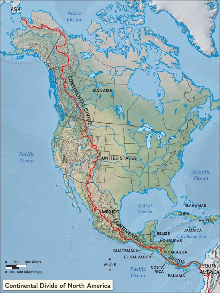
Map depicting the location of the Continental Divide in North America and Central America.
A Continuous Product of Subduction
Despite its many regional names, the American Cordillera is fundamentally one continuous geological phenomenon: nearly its entire length has been built by the subduction of oceanic tectonic plates, the Juan de Fuca, Cocos, and Nazca plates among them, beneath the lighter continental crust of the North American, Caribbean, and South American plates. This shared origin explains why volcanic and seismic activity runs almost unbroken along the Cordillera's length, from the Cascade volcanoes of the Pacific Northwest through Mexico's volcanic belts and Central America's volcanic arc to the active peaks of the Andes, all products of essentially the same tectonic process operating at different points along a single subduction margin.
The Continental Divide: Defining the Flow of Water
Running along the crest of the American Cordillera for its entire length is the Continental Divide of the Americas, the hydrological boundary separating watersheds that drain toward the Pacific Ocean from those draining toward the Atlantic, including the Gulf of Mexico and the Caribbean Sea. In North America, the divide additionally separates a third watershed, rivers draining toward the Arctic Ocean, from the other two.
This single line of high ground has shaped ecosystems, climate patterns, and human settlement across two entire continents. Rivers separated by only a few meters of ridge crest can travel toward oceans thousands of kilometers apart, and the divide's influence on rainfall distribution—rain shadows on one side, moisture-laden windward slopes on the other—has produced some of the sharpest ecological contrasts found anywhere on Earth, from the deserts of northern Mexico to the temperate rainforests of the Pacific Northwest to the cloud forests and páramo of the tropical Andes.
Diverse Landscapes and Ecosystems
The sheer length of the American Cordillera, spanning nearly the full range of Earth's latitudes in the Western Hemisphere, means that no other single mountain system on the planet passes through such an extreme range of climates and ecosystems: subarctic tundra in Alaska and northern Canada, temperate coniferous forest through the Rockies, arid desert and dry pine-oak forest through much of Mexico, tropical rainforest and cloud forest through Central America, and everything from Amazonian rainforest to high-altitude puna and permanent ice through the length of the Andes, before ending in the subantarctic forests and steppe of Tierra del Fuego. Each of the Cordillera's constituent ranges hosts its own distinct microclimates and levels of endemism, making the system as a whole one of the most biodiverse mountain chains on Earth.
Significance and Conservation
Beyond its geological and ecological significance, the Continental Divide has shaped national boundaries, historic trade and migration routes, and the placement of major cities throughout the Americas. Its role in defining major ecosystems and watersheds also makes it a critical consideration for conservation planning, since protecting any single stretch of the Cordillera in isolation often does little to protect the migratory species, water systems, and ecological processes that depend on connectivity along its length. Climate change and habitat fragmentation increasingly threaten that connectivity, from glacial retreat in the Andes to deforestation along the Central American segments, underscoring the value of conservation approaches, such as the Andes-Amazon connectivity corridors and the Mesoamerican Biological Corridor, that treat the Cordillera as the single connected system it geologically is.
Conclusion
The American Cordillera and the Continental Divide running along its spine are, in the end, a single shared inheritance across an entire hemisphere: one continuous mountain system that happens to answer to different names in different countries, and one continuous line of high ground that has shaped where every river on two continents ultimately flows. Seeing the Rockies, the Sierra Madre, Central America's volcanic highlands, and the Andes as regional chapters of the same geological story, rather than unrelated mountain ranges that happen to run roughly in the same direction, offers a fuller picture of how deeply connected the geography of the Americas truly is.
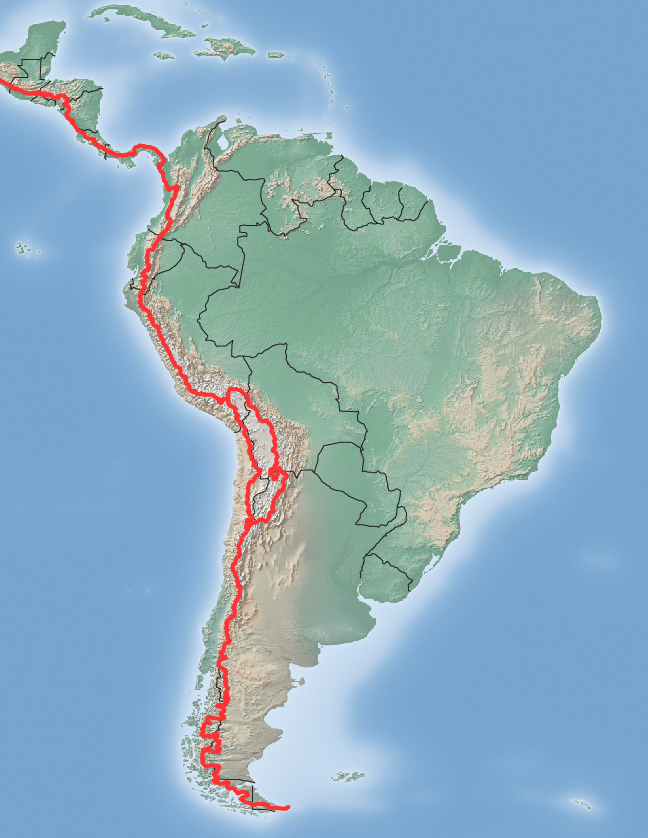
Map depicting the location of the Continental Divide in Central America and South America.