Central America's Mountain Heritage: From Volcanic Heights to Cloud Forests
Central America is shaped by tectonic plate collisions into a landscape of peaks, volcanoes, and mountain ranges. Stretching from Belize to Panama, these terrains form the isthmus's backbone, creating ecosystems that support biodiversity and influence the climate, culture, and economy of seven nations.
 https://www.flickr.com/photos/travicted/35537849712")
 https://www.flickr.com/photos/spinfly/16303174461")


 https://www.flickr.com/photos/homohominilupus/3168002877")

The Towering Backbone of Central America: A Journey Through the Region's Majestic Mountain Ranges
Central America stands as one of the world's most geologically dynamic regions, where the collision of tectonic plates has sculpted a dramatic landscape of towering peaks, active volcanoes, and rugged mountain ranges. Stretching from Belize in the north to Panama in the south, these mountainous terrains form the backbone of the Central American isthmus, creating diverse ecosystems that harbor extraordinary biodiversity while shaping the climate, culture, and economy of seven nations. From the volcanic peaks of Guatemala's Sierra Madre de Chiapas to the cloud-draped summits of Costa Rica's Cordillera de Talamanca, Central America's mountains tell a story of geological forces, ecological richness, and human adaptation spanning millennia.
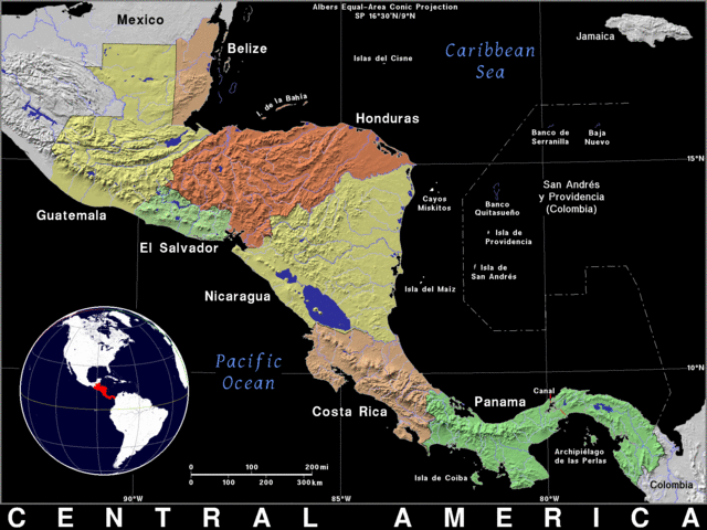
Relief map of Central America.
Belize: The Maya Mountains
Though Belize lacks the extensive mountain systems found elsewhere in Central America, the Maya Mountains in the country's southern region represent a significant elevated landscape. These low-to-medium-elevation peaks are characterized by rugged limestone terrain and dense tropical forests that harbor unique cave systems and archaeological treasures. The Maya Mountains hold particular ecological importance as a refuge for endangered species and serve as a watershed for several major river systems that drain toward the Caribbean Sea.
Guatemala: Land of Highland Peaks
Guatemala boasts some of Central America's most impressive mountain ranges, shaped by complex geological processes and volcanic activity. The country's diverse topography gives rise to distinct highland regions that have profoundly influenced its Indigenous cultures and agricultural practices.
Sierra Madre de Chiapas
Extending from southern Mexico into Guatemala and El Salvador, the Sierra Madre de Chiapas represents Central America's highest mountain range. Tajumulco, the range's highest peak, rises to 4,220 m (13,845 ft), making it the tallest point in Central America. The range features numerous volcanic peaks surrounded by cloud forests and highland páramo ecosystems, creating a unique environment where temperate and tropical species converge.
Sierra de los Cuchumatanes
The Sierra de los Cuchumatanes dominates Guatemala's western highlands with its dramatic plateaus and deep valleys. Notable as Central America's highest non-volcanic mountain range, the Cuchumatanes Massif creates some of the region's most spectacular and least explored mountainous terrain. The range's high-altitude environments support unique plant communities adapted to cooler temperatures and seasonal frost.
Sierra de las Minas
Eastern Guatemala's Sierra de las Minas extends 15-30 km (10-20 mi) in width, bordered by the Polochic River valley to the north and the Motagua River valley to the south. The Salamá River valley forms its western boundary, separating it from the Chuacús mountain range. The Sierra de las Minas serves as a critical watershed and biodiversity corridor, connecting highland and lowland ecosystems.
El Salvador: Volcanic Cordilleras
Despite being Central America's smallest country, El Salvador is home to numerous significant mountain ranges that define its geography and support its agricultural economy. These ranges, primarily volcanic in origin, create the country's characteristic landscape of fertile valleys and steep-sided peaks.
Cordillera de Apaneca-Ilamatepec
Located in western El Salvador near the Guatemalan border, the Cordillera de Apaneca-Ilamatepec forms part of the Central American Volcanic Arc. The range runs parallel to the Pacific coast and features the Ilamatepec Volcano (Santa Ana Volcano), which stands as El Salvador's highest point. Rolling hills, deep valleys, and cloud forests characterize the region, creating ideal conditions for coffee cultivation.
Cordillera del Bálsamo
The Cordillera del Bálsamo stretches across the departments of Sonsonate and La Libertad as a coastal mountain range. Named after the balsam trees growing on its slopes, the range extends from Sonsonate to San Salvador's Puerta del Diablo, forming a natural barrier between the Pacific Ocean and inland valleys.
Additional Ranges
El Salvador's mountainous landscape includes several other significant ranges: the Sierra de Lempa runs through central and eastern regions, providing important agricultural lands near the Lempa River; the Sierra de San Vicente features the San Vicente Volcano in the country's center; the Cordillera de Tecapa-Chinameca extends along the eastern border with Honduras, including the active Volcán Tecapa and Volcán Chinameca; and the Cordillera de Los Planes contains Cerro Guazapa, El Salvador's second-highest peak at 2,381 m (7,811 ft).
Honduras: Diverse Mountain Landscapes
Honduras boasts a varied topography, characterized by several significant mountain ranges that contribute to the country's diverse ecosystems and rich cultural heritage. These ranges create distinct climatic zones and serve as important watersheds for both the Caribbean and Pacific drainage systems.
Cordillera de Merendón
The Cordillera de Merendón extends east to west for approximately 100 km (62 mi) across northern Honduras as part of the Central American Volcanic Arc. Cerro El Pital, the range's highest peak, reaches 2,849 m (9,347 ft) and supports lush cloud forests with diverse flora and fauna adapted to the cool, moist conditions.
Cordillera de Agalta
Located in northeastern Honduras, the Cordillera de Agalta features the country's highest peak, Cerro Las Minas, which reaches an elevation of 2,870 m (9,416 ft). The range serves as a critical watershed and biodiversity corridor, connecting lowland rainforests with highland pine forests.
Cordillera de Nombre de Dios
The southwestern Cordillera de Nombre de Dios holds special cultural significance as the location of the Maya archaeological site of Copán, one of Central America's most important pre-Columbian centers. The range's limestone geology has created numerous cave systems and underground rivers.
Nicaragua: Central Highlands and Volcanic Chains
Nicaragua's diverse topography features several mountain ranges, creating the country's characteristic pattern of highlands, valleys, and volcanic landscapes. These ranges influence regional climate patterns and provide critical watersheds for both the Pacific and Caribbean drainage systems.
Cordillera Isabelia
The northern portion of Nicaragua's central mountain range, Cordillera Isabelia, runs northwest to southeast through the country's center. Pico Mogotón, reaching 2,107 m (6,912 ft) on the Honduran border, represents the range's highest point. Deep valleys and forested slopes characterize much of the range.
Cordillera de los Maribios
Western Nicaragua's Cordillera de los Maribios extends northwest to southeast and contains several active and dormant volcanoes, including the prominent Momotombo and the frequently active Cerro Negro. The range demonstrates ongoing volcanic activity that continues to shape the landscape.
Cordillera de Dipilto y Jalapa
Running north-south from Jalapa toward the Honduran border, the Cordillera de Dipilto y Jalapa serves as an important binational watershed. The range includes Mogotón, Nicaragua's highest peak at 2,085 m (6,841 ft), which lies precisely on the Honduras-Nicaragua border.
Costa Rica: Volcanic Grandeur and Cloud Forests
Costa Rica's mountain ranges are among Central America's most spectacular and biodiverse landscapes. The country's position along the volcanic chain yields dramatic peaks, while supporting an extraordinary variety of ecosystems, ranging from tropical dry forests to high-altitude páramo.
Cordillera de Guanacaste
Northwestern Costa Rica's Cordillera de Guanacaste forms part of the larger Central American volcanic chain. The range encompasses active and dormant volcanoes, including Rincón de la Vieja, Miravalles, and Tenorio, which create landscapes shaped by ongoing geothermal activity and support diverse flora and fauna adapted to volcanic soils.
Cordillera de Tilarán
The Cordillera de Tilarán connects the Guanacaste and Central mountain ranges, running northwest to southeast. The famous Arenal Volcano and surrounding cloud forests define the region, while Lake Arenal, Costa Rica's largest lake, provides water resources and recreational opportunities.
Cordillera Central
Also known as the Volcanic Cordillera, the Cordillera Central spans northern and central Costa Rica, encompassing several active volcanoes, including Poás, Irazú, and Turrialba. The range features diverse forest types, ranging from cloud forests to oak forests, which support abundant wildlife across varied elevational zones.
Cordillera de Talamanca
One of Central America's most extensive mountain ranges, the Cordillera de Talamanca runs along southern Costa Rica and extends into Panama. Cerro Chirripó, the range's highest peak, rises to 3,819 m (12,530 ft), making it both Costa Rica's and Central America's highest non-volcanic summit. The region supports high-altitude páramo ecosystems, tropical cloud forests, and exceptional biodiversity.
Panama: Isthmian Mountains and Biological Corridors
Panama's strategic position as the narrowest point between North and South America creates unique mountain landscapes that serve as biological corridors for species migration. The country's ranges support diverse ecosystems while providing critical watershed functions for both the Atlantic and Pacific drainage systems.
Cordillera de Talamanca
Extending from Costa Rica into western Panama, the Cordillera de Talamanca continues as one of the country's most significant mountain ranges. Volcán Barú, Panama's highest peak at approximately 3,474 m (11,398 ft), anchors the range and provides habitat for unique high-altitude species. The Talamanca range is part of the Mesoamerican Biological Corridor, facilitating the movement of species between North and South America.
Serranía de Tabasará
The Serranía de Tabasará runs parallel to the Cordillera de Talamanca in southern Panama, featuring forested slopes that provide habitat for diverse wildlife species. The range plays a crucial role in water catchment, supplying freshwater to rivers flowing toward both the Pacific and Atlantic coasts.
Cordillera Central and Serranía del Darién
Panama's Cordillera Central extends parallel to the Panama Canal, while the Serranía del Darién occupies eastern regions near the Colombian border. The Darién range forms part of the famous Darién Gap, an area of dense rainforest and swamps that has remained largely impassable. These eastern mountains support unique ecosystems and Indigenous communities maintaining traditional lifestyles.
Geological Forces and Formation
Central America's mountain ranges are the result of complex tectonic processes occurring at the intersection of several major tectonic plates. The subduction of the Cocos Plate beneath the Caribbean Plate creates a volcanic arc that extends from Guatemala to Costa Rica, while transform faults and volcanic activity continue to shape the landscape. The region's geology includes both volcanic ranges formed by ongoing subduction and older, non-volcanic ranges uplifted through tectonic compression.
Ecological Significance and Biodiversity
The mountain ranges of Central America create diverse microclimates and ecosystems that support extraordinary biodiversity. Elevational gradients produce distinct vegetation zones, from lowland tropical forests through cloud forests to high-altitude páramo. Many endemic species have evolved in isolated mountain environments, while the ranges serve as corridors connecting larger ecosystem blocks. Cloud forests, particularly abundant in Central American mountains, capture moisture from trade winds and support unique communities of epiphytes, amphibians, and other specialized organisms.
Cultural and Economic Importance
Central America's mountains have profoundly influenced human settlement patterns, agriculture, and culture throughout history. Highland valleys provide ideal conditions for coffee cultivation, which drives much of the region's economy. Indigenous peoples developed sophisticated agricultural systems that were adapted to mountain environments, as evidenced by archaeological sites like Copán, which demonstrate the cultural significance of these landscapes. Modern communities continue to depend on mountain watersheds for water resources while developing eco-tourism industries around the scenic beauty and biodiversity of mountain environments.
Summary
The mountain ranges of Central America form a spectacular and geologically active backbone that defines the character of the entire region. From Belize's limestone Maya Mountains to Panama's biodiverse cordilleras, these ranges create the fundamental geographic framework that shapes climate, ecology, and human culture across seven nations. The volcanic peaks of Guatemala's Sierra Madre de Chiapas reach heights exceeding 4,200 m (13,780 ft), while Costa Rica's Cordillera de Talamanca extends into Panama as one of the hemisphere's most important biological corridors.
These mountains continue evolving through ongoing tectonic processes, supporting extraordinary biodiversity in ecosystems ranging from cloud forests to high-altitude páramo. As watersheds, cultural landscapes, and centers of endemic species, Central America's mountain ranges represent an invaluable natural heritage that requires continued conservation efforts to preserve their ecological integrity and cultural significance for future generations. The towering peaks and deep valleys of these ranges stand as a testament to the dynamic geological forces that continue shaping one of the world's most biodiverse and culturally rich regions.
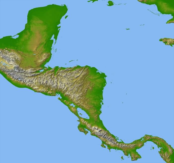
Relief map of Central America.