Costa Rica's Magnificent Mountain Ranges: Volcanic Giants and Biodiversity Hotspots
Costa Rica, though small in size, possesses one of the most remarkable and geologically active mountain systems in Central America. These ranges not only define Costa Rica's topography but also serve as the backbone of its legendary biodiversity, climate regulation, and cultural identity.
 https://www.flickr.com/photos/travicted/35537849712")
 https://www.flickr.com/photos/spinfly/16303174461")


, CC BY-SA 4.0, via Wikimedia Commons")

Fire and Ice: The Dynamic Mountain Systems of Costa Rica
Costa Rica, though small in size, possesses one of the most remarkable and geologically active mountain systems in Central America. This nation, spanning just 51,100 square kilometers (19,730 square miles), is traversed by multiple mountain ranges that form part of the Central American Volcanic Arc, creating a dramatic landscape of active volcanoes, cloud forests, and alpine ecosystems. These mountain ranges not only define Costa Rica's topography but also serve as the backbone of its legendary biodiversity, climate regulation, and cultural identity. From the towering volcanic peaks that pierce the clouds to the mist-shrouded cloud forests that harbor countless endemic species, Costa Rica's mountains represent some of the most biodiverse and geologically active landscapes on Earth.
The Cordillera de Guanacaste: Northwestern Volcanic Chain
Geographic Overview and Volcanic Activity
The Cordillera de Guanacaste extends approximately 110 kilometers (68 miles) through northwestern Costa Rica, forming part of the Central America Volcanic Arc. This mountain range represents the southern continuation of Nicaragua's volcanic highlands and includes some of Costa Rica's most active and historically significant volcanoes. The cordillera runs roughly parallel to the Pacific coast, creating a natural barrier that influences regional climate patterns and serves as a continental divide.
The range is characterized by a series of volcanic peaks and massifs, with elevations ranging from 500 meters (1,640 feet) in the foothills to over 1,900 meters (6,234 feet) at the highest summits. The mountains are relatively young in geological terms, with most formations dating to the Pleistocene epoch, and several volcanoes remaining active today. The volcanic nature of these mountains has created fertile soils that support diverse ecosystems and a range of agricultural activities.
Climate and Ecosystems
The Cordillera de Guanacaste experiences distinct wet and dry seasons, with the Pacific slope receiving significantly less rainfall than the Caribbean-facing slopes of other Costa Rican mountain ranges. Annual precipitation varies from 1,200 millimeters (47 inches) in the driest areas to over 3,000 millimeters (118 inches) in higher elevations and windward slopes.
This climatic variation supports a diverse range of ecosystems, from tropical dry forests at lower elevations to cloud forests near the summits. The dry forests of Guanacaste are particularly significant as they represent one of the most threatened ecosystems in Central America. These forests are characterized by deciduous trees that shed their leaves during the dry season, creating dramatic seasonal changes in the landscape's appearance.
The Cordillera de Tilarán: Central Volcanic Highlands
Structure and Geographic Significance
The Cordillera de Tilarán occupies the central portion of Costa Rica's volcanic spine, extending approximately 80 kilometers (50 miles) from the Cordillera de Guanacaste in the northwest to the Cordillera Central in the southeast. This range serves as a crucial link in Costa Rica's continental divide and contains some of the country's most important watersheds, including the sources of rivers that flow to both the Pacific Ocean and the Caribbean Sea.
The range reaches its highest elevation at approximately 1,842 meters (6,043 feet) and is characterized by a series of volcanic peaks, crater lakes, and extensive cloud forest coverage. The mountains create a natural barrier that significantly influences local weather patterns, with the Caribbean-facing slopes receiving substantially more precipitation than the Pacific slopes, creating distinct microclimates within relatively short distances.
The Monteverde Cloud Forest Complex
One of the most significant features of the Cordillera de Tilarán is the Monteverde Cloud Forest Complex, which encompasses several protected areas, including the Monteverde Cloud Forest Reserve and Children's Eternal Rainforest. These cloud forests exist at elevations between 1,200 and 1,800 meters (3,937 and 5,906 feet), where persistent cloud cover creates unique conditions supporting extraordinary biodiversity.
The cloud forests are characterized by high humidity, frequent fog, and cooler temperatures that rarely exceed 20°C (68°F). These conditions support epiphytic plants, including hundreds of orchid species, bromeliads, and mosses that create a three-dimensional garden in the forest canopy. The region is home to iconic species, including the resplendent quetzal, the three-wattled bellbird, and numerous endemic amphibians and insects.
The Cordillera Central: The Heart of Costa Rica
Geographic Position and Volcanic Features
The Cordillera Central represents the most prominent and geologically active mountain range in Costa Rica, extending approximately 80 kilometers (50 miles) through the center of the country. This range contains four major volcanic massifs: Poás, Barva, Irazú, and Turrialba, with the latter two being among the most active volcanoes in Central America. The cordillera reaches its highest point at Irazú Volcano, which rises to 3,432 meters (11,260 feet) above sea level.
The range serves as the primary continental divide for central Costa Rica, with rivers flowing north to the Caribbean Sea and south to the Pacific Ocean. The volcanic activity has created a complex topography of peaks, craters, crater lakes, and extensive lava fields that continue to shape the landscape. The proximity of these volcanoes to Costa Rica's Central Valley, where the majority of the population lives, makes this range particularly significant for both geological monitoring and tourism.
The Central Valley's Mountain Frame
The Cordillera Central, along with the Cordillera de Talamanca to the south, frames Costa Rica's Central Valley (Valle Central), home to approximately 60% of the country's population, including the capital city of San José. This valley, situated at elevations between 800 and 1,500 meters (2,625 and 4,921 feet), enjoys a temperate climate year-round due to its altitude and protection from the surrounding mountains.
The volcanic soils of the Central Valley are among the most fertile in Central America, supporting intensive agriculture, including world-renowned coffee plantations. The mountains surrounding the valley also provide crucial water resources, with numerous rivers originating from the high-altitude watersheds and flowing through the valley to both coasts.
The Cordillera de Talamanca: Costa Rica's Highest Range
Geographic Extent and Geological Significance
The Cordillera de Talamanca represents Costa Rica's most extensive and highest mountain range, stretching approximately 300 kilometers (186 miles) from central Costa Rica into western Panama. Unlike the other mountain ranges in Costa Rica, the Talamanca range is primarily non-volcanic in origin, consisting of uplifted sedimentary and igneous rocks that date back millions of years. This geological difference creates distinct landscapes and ecosystems compared to the volcanic ranges to the north.
The range reaches its highest point at Cerro Chirripó, which at 3,819 meters (12,530 feet) is the highest peak in Costa Rica and the second-highest in Central America after Guatemala's Volcán Tajumulco. The Talamanca range is characterized by its rugged terrain, deep valleys, glacial cirques from past ice ages, and extensive cloud forest and páramo ecosystems at higher elevations.
The Páramo Ecosystem
Above 3,000 meters (9,843 feet), the Cordillera de Talamanca supports Costa Rica's only páramo ecosystem, a high-altitude tropical grassland similar to those found in the Andes. The páramo is characterized by harsh conditions including frequent temperature fluctuations, strong winds, high solar radiation, and regular frost. Despite these challenging conditions, the páramo supports specialized plant communities including endemic species found nowhere else in Central America.
The páramo ecosystem serves as a crucial water source for much of southern Costa Rica, acting as a natural sponge that captures moisture from clouds and gradually releases it into the surrounding watersheds. This ecosystem is particularly vulnerable to climate change, and its preservation is crucial for maintaining water resources and preserving its unique biodiversity.
Chirripó National Park and La Amistad International Park
Much of the Cordillera de Talamanca is protected within Chirripó National Park and La Amistad International Park, the latter of which is a UNESCO World Heritage Site shared between Costa Rica and Panama. These protected areas encompass over 400,000 hectares (988,000 acres) and represent one of the largest continuous forest blocks in Central America.
The parks protect an extraordinary range of ecosystems, from lowland rainforests to high-altitude páramos, and serve as crucial habitat for numerous endangered species, including jaguars, pumas, tapirs, and harpy eagles. The region also supports significant Indigenous populations, including the Bribri and Cabécar peoples, who maintain traditional lifestyles and possess deep knowledge of mountain ecosystems.
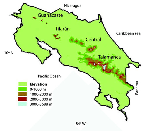
Map depicting Costa Rica's main mountain ranges: Guanacaste, Tilarán, Central, and Talamanca.
Major Volcanic Peaks and Their Characteristics
Active Volcanic Giants
Irazú Volcano stands as Costa Rica's highest volcano at 3,432 meters (11,260 feet) and is located just 54 kilometers (34 miles) from San José. The volcano has been active throughout recorded history, with its most recent major eruption occurring from 1963 to 1965. Irazú features multiple craters, including the main crater, which contains a striking green-colored crater lake. On clear days, both the Pacific Ocean and Caribbean Sea are visible from the summit, making it one of the few places on Earth where both oceans can be seen simultaneously.
Turrialba Volcano, which reaches 3,340 meters (10,958 feet), has been Costa Rica's most active volcano in recent years, with significant eruptive activity resuming in 2010 after a period of dormancy lasting decades. The volcano poses ongoing challenges for nearby communities and agriculture due to frequent ash emissions that affect air quality and crop production in the surrounding areas.
Poás Volcano, at 2,708 meters (8,885 feet), is one of Costa Rica's most visited volcanoes due to its accessibility and spectacular crater lake. The main crater measures nearly 1.5 kilometers (0.9 miles) in diameter and contains one of the world's most acidic crater lakes. The volcano has exhibited increased activity in recent years, with periods of volcanic unrest that have occasionally necessitated the closure of the national park to visitors.
Dormant and Extinct Peaks
Rincón de la Vieja, rising to 1,916 meters (6,286 feet) in the Cordillera de Guanacaste, is an active volcanic complex featuring multiple peaks, crater lakes, hot springs, and fumaroles. While not as tall as the central volcanoes, Rincón de la Vieja is significant for its diverse volcanic features and the extensive protected area that surrounds it.
Barva Volcano, at 2,896 meters (9,501 feet), is considered dormant and is notable for its well-preserved crater and the cloud forests that cover its slopes. The volcano is accessible through Braulio Carrillo National Park and offers excellent hiking opportunities through pristine montane ecosystems.
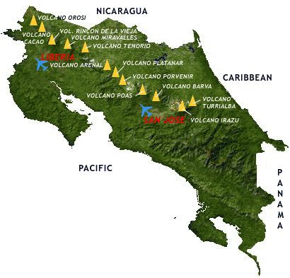
Map of active and inactive volcanoes throughout the Cordillera Volcánica Central in Costa Rica.
Non-Volcanic Peaks of the Talamanca Range
The Highest Summits
Cerro Chirripó, at 3,819 meters (12,530 feet), dominates the Talamanca landscape and requires a challenging multi-day trek to reach its summit. The mountain's name derives from the Indigenous Cabécar word meaning "land of eternal waters," reflecting its role as a crucial watershed. The summit area features several peaks within a small area, glacial lakes, and, on clear days, views of both the Pacific Ocean and the Caribbean Sea.
Cerro Ventisqueros, reaching 3,812 meters (12,507 feet), is the second-highest peak in Costa Rica and is located near Chirripó. The mountain's name, meaning "glacial winds," references the harsh conditions near the summit and the evidence of past glacial activity, as seen in the form of cirques and moraines.
Cerro Crestones, at 3,760 meters (12,336 feet), represents another significant peak in the Chirripó massif. These peaks are characterized by their rocky, exposed summits that rise above the tree line and support specialized high-altitude plant communities.
Complete List of Major Costa Rican Peaks
Cordillera de Talamanca
- Cerro Chirripó - 3,819m (12,530ft) - Non-volcanic
- Cerro Ventisqueros - 3,812m (12,507ft) - Non-volcanic
- Cerro Crestones - 3,760m (12,336ft) - Non-volcanic
- Cerro de la Muerte - 3,320m (10,892ft) - Non-volcanic
- Cerro Buena Vista - 3,300m (10,827ft) - Non-volcanic
- Cerro Chompipe - 2,594m (8,511ft) - Non-volcanic
Cordillera Central
- Irazú Volcano - 3,432m (11,260ft) - Active volcano
- Turrialba Volcano - 3,340m (10,958ft) - Active volcano
- Barva Volcano - 2,896m (9,501ft) - Dormant volcano
- Poás Volcano - 2,708m (8,885ft) - Active volcano
Cordillera de Guanacaste
- Miravalles Volcano - 2,028m (6,654ft) - Dormant volcano
- Rincón de la Vieja - 1,916m (6,286ft) - Active volcano
- Tenorio Volcano - 1,916m (6,286ft) - Dormant volcano
Cordillera de Tilarán
- Arenal Volcano - 1,670m (5,479ft) - Active volcano
Climate Patterns and Altitudinal Zonation
Tropical Climate Zones
Costa Rica's mountains create distinct altitudinal climate zones that support different ecosystems and agricultural activities. The lowlands (0-800 meters/0-2,625 feet) experience hot, humid tropical conditions with temperatures averaging 26-28°C (79-82°F) year-round. The premontane zone (800-1,500 meters/2,625-4,921 feet) enjoys more temperate conditions with temperatures ranging from 18-24°C (64-75°F), making it ideal for coffee cultivation and human settlement.
The montane zone (1,500-2,500 meters/4,921-8,202 feet) experiences cooler temperatures averaging 12-18°C (54-64°F) and supports cloud forest ecosystems. Above 2,500 meters (8,202 feet), the alpine zone features cold temperatures that can drop below freezing, especially at night, and supports specialized high-altitude plant communities.
Rainfall Patterns and Seasonality
Costa Rica's mountains significantly influence precipitation patterns, with the Caribbean slopes receiving 3,000-6,000 millimeters (118-236 inches) of annual rainfall, while some Pacific slopes receive as little as 1,200 millimeters (47 inches). The country experiences distinct wet (May to November) and dry (December to April) seasons, although the timing and intensity vary with elevation and geographic location.
The mountains create orographic precipitation effects, where moist air masses are forced upward, cooling and releasing their moisture as rain or fog. This process is particularly pronounced on the Caribbean-facing slopes, which intercept moisture-laden trade winds year-round, supporting the lush rainforests and cloud forests that characterize these regions.
Biodiversity and Endemic Species
Cloud Forest Ecosystems
Costa Rica's mountain cloud forests represent some of the most biodiverse ecosystems on Earth, supporting an estimated 2,500 plant species, 400 bird species, and thousands of insect species within relatively small areas. These ecosystems are characterized by persistent cloud cover that provides constant moisture, supporting extensive epiphytic communities of orchids, bromeliads, ferns, and mosses.
The cloud forests serve as crucial habitat for numerous endemic and endangered species, including the resplendent quetzal, three-wattled bellbird, golden toad (possibly extinct), and hundreds of endemic amphibian species. The complex three-dimensional structure of cloud forests, with multiple canopy layers and extensive epiphytic growth, creates numerous microhabitats that support specialized species found nowhere else on Earth.
High-Altitude Endemism
The páramo and sub-páramo zones of the Cordillera de Talamanca support numerous endemic plant species adapted to harsh high-altitude conditions. These include endemic genera of composites, grasses, and shrubs that have evolved in isolation on Costa Rica's highest peaks. Many of these species are found only in the Chirripó region and are considered relics from cooler climatic periods when similar vegetation was more widespread.
The high elevations also support specialized animal communities, including endemic salamanders, lizards, and insects adapted to cool temperatures and high solar radiation. These high-altitude ecosystems serve as natural laboratories for studying adaptation to extreme conditions and the impacts of climate change.
Geological History and Formation
Volcanic Arc Development
Costa Rica's volcanic mountains are part of the Central America Volcanic Arc, formed by the subduction of the Cocos Plate beneath the Caribbean Plate. This ongoing tectonic process has created the chain of volcanoes that extends from Guatemala to Panama, with Costa Rica containing some of the most active segments of this arc.
The volcanic activity began approximately 20 million years ago, with the current configuration of volcanic ranges developing over the past 5 million years. The diverse ages and compositions of volcanic rocks create a range of landscapes and soil types that support varied ecosystems and agricultural activities.
Talamanca Orogeny
The Cordillera de Talamanca formed through a different geological process known as the Talamanca Orogeny, which involved the collision and uplift of oceanic terranes and sedimentary rocks. This process created the non-volcanic mountains that characterize the southern portion of Costa Rica and represent some of the oldest rocks in the country.
The complex geological history of the Talamanca range has resulted in a diverse array of rock types, including limestone, sandstone, igneous intrusions, and metamorphic rocks. This geological diversity contributes to the region's extraordinary biodiversity by creating varied soil types, drainage patterns, and microhabitats.
Water Resources and Watersheds
Continental Divide Functions
Costa Rica's mountain ranges serve as the continental divide, with rivers flowing to both the Pacific Ocean and the Caribbean Sea originating from the high-altitude watersheds. The mountains capture moisture from trade winds and seasonal precipitation, storing it in cloud forests, wetlands, and underground aquifers before gradually releasing it through river systems.
Major river systems originating in the mountains include the Reventazón, Sarapiquí, and San Juan rivers flowing to the Caribbean, and the Tárcoles, Grande de Térraba, and Sierpe rivers flowing to the Pacific. These watersheds provide water for hydroelectric power generation, irrigation, domestic use, and ecosystem maintenance.
Hydroelectric Power Generation
Costa Rica generates over 75% of its electricity from hydroelectric plants, most of which depend on rivers originating in the mountain ranges. Major hydroelectric facilities include plants on the Reventazón River system, which originates near Irazú Volcano, and numerous smaller installations throughout the mountainous regions.
The reliability of hydroelectric power depends on maintaining healthy mountain watersheds that can capture and store precipitation effectively. Climate change and deforestation pose significant threats to these watershed functions, making mountain conservation crucial for energy security.
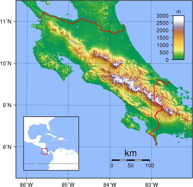
Topographic map of Costa Rica.
Conservation Challenges and Protected Areas
National Park System
Costa Rica has established an extensive system of national parks and protected areas that encompass a significant portion of its mountainous regions. Major protected areas include Chirripó National Park, Irazú Volcano National Park, Poás Volcano National Park, Braulio Carrillo National Park, and sections of La Amistad International Park.
These protected areas face numerous challenges, including limited funding, illegal hunting and logging, agricultural encroachment, and the impacts of climate change. The fragmentation of forest corridors between protected areas also poses threats to wildlife movement and genetic exchange between populations.
Climate Change Impacts
Costa Rica's mountain ecosystems are particularly vulnerable to climate change, with rising temperatures causing upward shifts in vegetation zones and threatening high-altitude species that have limited dispersal options. Cloud forest ecosystems are particularly vulnerable, as changing temperature and humidity patterns impact cloud formation and moisture availability.
The glacial features on Chirripó, though small, are disappearing due to warming temperatures, and the timing of wet and dry seasons is shifting, affecting both natural ecosystems and agricultural activities. These changes necessitate adaptive management strategies and intensified conservation efforts to preserve ecosystem integrity.
Cultural and Economic Significance
Indigenous Heritage
Costa Rica's mountains have been home to Indigenous peoples for thousands of years, with groups such as the Bribri and Cabécar maintaining traditional lifestyles in the Talamanca region. These communities possess detailed knowledge of mountain ecosystems and sustainable resource management practices that have evolved over generations.
Indigenous territories encompass significant portions of the Cordillera de Talamanca, and these communities play crucial roles in forest conservation and biodiversity protection. Their traditional ecological knowledge provides valuable insights for conservation strategies and sustainable development approaches.
Adventure Tourism and Ecotourism
Costa Rica's mountains attract hundreds of thousands of visitors annually, contributing significantly to the national economy through adventure tourism and ecotourism activities. Popular activities include volcano viewing, cloud forest hiking, bird watching, canopy tours, and summit climbing.
The accessibility of many mountain areas, combined with well-developed tourism infrastructure, makes Costa Rica a premier destination for nature-based tourism. However, tourism also presents challenges, including trail erosion, wildlife disturbance, and pressure on protected area resources.
Agricultural Importance
The mountain regions support important agricultural activities, particularly coffee cultivation in the Central Valley and surrounding slopes. Costa Rican coffee, grown at elevations between 800 and 1,600 meters (2,625 and 5,249 feet), is renowned worldwide for its quality and commands premium prices in international markets.
The volcanic soils and favorable climate conditions in mountainous areas also support the cultivation of other crops, including vegetables, flowers, and fruits, for both domestic consumption and export. Sustainable agricultural practices are increasingly important for maintaining soil fertility and watershed functions.
Research and Scientific Significance
Biological Research Stations
Costa Rica's mountains are home to numerous biological research stations that have made significant contributions to tropical ecology and conservation biology. The Monteverde Cloud Forest Reserve, La Selva Biological Station, and research facilities in Chirripó National Park have been sites for groundbreaking research on tropical ecosystems, the impacts of climate change, and species interactions.
These research stations attract scientists from around the world and have produced thousands of scientific publications that advance understanding of tropical mountain ecosystems. Long-term ecological monitoring programs provide crucial data for understanding ecosystem changes and developing conservation strategies.
Volcanic Monitoring
Costa Rica maintains sophisticated volcanic monitoring systems that track activity at active volcanoes and provide early warning for potentially dangerous eruptions. The Universidad de Costa Rica and OVSICORI (Volcanological and Seismological Observatory) operate networks of seismometers, gas sensors, and thermal cameras that continuously monitor volcanic activity.
This monitoring is crucial for public safety, given the proximity of active volcanoes to populated areas, and also contributes to scientific understanding of volcanic processes. Costa Rica's volcanoes serve as natural laboratories for studying magma chemistry, eruption dynamics, and volcanic hazards.
Future Challenges and Conservation Priorities
Sustainable Development
Balancing conservation needs with economic development remains a critical challenge for Costa Rica's mountain regions. Population growth, urbanization, and agricultural expansion continue to pressure protected areas and critical watersheds. Developing sustainable tourism practices, promoting certified sustainable agriculture, and enhancing protected area management are crucial for achieving long-term conservation success.
Payment for ecosystem services programs, which compensate landowners for maintaining forest cover and watershed functions, represent innovative approaches to conservation that recognize the economic value of mountain ecosystems. These programs have shown success in Costa Rica and serve as models for other countries.
Climate Adaptation
Climate change adaptation strategies are crucial for maintaining the integrity of mountain ecosystems and the services they provide. These strategies include establishing biological corridors that allow species to migrate to suitable habitats as conditions change, protecting high-altitude refugia, and developing drought-resistant agricultural practices.
International cooperation is crucial for mitigating the impacts of climate change on mountain ecosystems, particularly for species and ecosystems that span multiple national borders. The La Amistad International Park represents a model for transboundary conservation that could be expanded to address climate change challenges.
Conclusion
The mountain ranges of Costa Rica represent an extraordinary natural heritage that extends far beyond their impressive physical dimensions. These peaks and ranges serve as the foundation for the country's remarkable biodiversity, provide essential water resources, regulate climate patterns, and support both traditional cultures and modern economic activities. From the active volcanic craters that remind us of Earth's dynamic processes to the cloud forests that harbor countless endemic species, Costa Rica's mountains embody the complex interactions between geological processes, climate systems, and biological evolution.
The volcanic nature of most Costa Rican mountains creates a landscape in constant flux, where new land is formed while existing features are modified by ongoing geological processes. This dynamism, combined with the country's position as a biological bridge between North and South America, has created conditions that support extraordinary biodiversity within a relatively small geographic area.
As Costa Rica faces the challenges of the 21st century, including climate change, population growth, and economic development pressures, the conservation and sustainable management of mountain ecosystems becomes increasingly critical. These mountains serve as natural infrastructure that provides essential services for human well-being, including water supply, climate regulation, disaster risk reduction, and carbon sequestration.
The success of Costa Rica's conservation efforts, which have maintained forest cover and protected biodiversity despite significant development pressures, offers hope and lessons for other countries facing similar challenges. The integration of protected areas, sustainable development practices, payments for ecosystem services, and community-based conservation demonstrates that it is possible to balance conservation and development needs.
Looking toward the future, Costa Rica's mountains will continue to serve as living laboratories for understanding ecosystem processes, climate change impacts, and conservation strategies. The knowledge gained from research in these mountain ecosystems contributes not only to local conservation efforts but also to global understanding of how mountain ecosystems function and respond to environmental changes.
The peaks that rise from Costa Rica's landscapes—from Chirripó's páramo heights to the steaming craters of active volcanoes—stand as monuments to the power of natural processes and the resilience of life. They remind us that conservation is not just about protecting individual species or scenic landscapes, but about maintaining the complex systems that support all life on Earth. In protecting these mountains, Costa Rica protects not only its natural heritage but also its future prosperity and the well-being of future generations.