The Trans-Mexican Volcanic Belt: Unveiling Mexico's Geological Marvels
The Trans-Mexican Volcanic Belt, also known as the Cordillera Neo-Volcánica, is a geological feature in south-central Mexico. It extends from the Pacific Ocean to the Gulf of Mexico, includes an active volcanic arc, and illustrates the dynamic interactions between tectonic plates over millions of years.
 - by júbilo haku (CC BY-NC-ND 2.0) https://www.flickr.com/photos/jubilo/47161058471")

, is a Mexican volcano located in the State of Mexico, between the valleys of Toluca and Tenango (Valle del Matlatzinco). - by Alejandro Hernández Osuna (Public Domain) https://www.flickr.com/photos/155674394@N06/49058503122")

 via Wikimedia Commons")
 https://www.flickr.com/photos/155674394@N06/49058277386")
The Trans-Mexican Volcanic Belt: Unveiling Mexico's Geological Marvels
The Trans-Mexican Volcanic Belt, also known as the Cordillera Neo-Volcánica, Eje Volcánico, or Sierra Volcánica Transversal, is a geological masterpiece stretching approximately 1,000 kilometers (620 miles) from the Pacific Ocean to the Gulf of Mexico in south-central Mexico. This volcanic belt, which encompasses an active volcanic arc over an area of about 160,000 square kilometers (62,000 square miles), tells the dynamic interplay between tectonic plates that have unfolded over millions of years.
Formation and Tectonic Context
Situated atop the Rivera (microplate) and Cocos Plate, the Trans-Mexican Volcanic Belt was sculpted through the intricate dance of these plates subducting beneath the North American Plate along the northern fringe of the Middle America Trench. The Cocos Plate shares borders with the North American Plate, Caribbean Plate, and Pacific Plate to the northeast, west, and south. Preceding the emergence of the Trans-Mexican Volcanic Belt, the Sierra Madre Occidental, an older volcanic belt, graced the region.
Ecological Marvels
Ecologically, this volcanic expanse forms the Trans-Mexican Volcanic Belt pine–oak forests ecoregion, a subtropical coniferous forest that hosts an array of endemic species. The region's ecological diversity reflects the symbiotic relationship between its geological and biological components.
Geographical Traverse
The volcanic belt, known locally as the Sierra Nevada, traverses multiple Mexican states from west to east, including Colima, Jalisco, northern Michoacán, Guanajuato, southern Querétaro, México, southern Hidalgo, Distrito Federal, northern Morelos, Puebla, Tlaxcala, and central Veracruz.
The southern boundary of the Mexican Plateau lies just north of this volcanic belt, flanked by the Sierra Madre Mountain System: the Sierra Madre Occidental to the west, the Sierra Madre Oriental to the east, and the Sierra Madre del Sur to the south. The Sierra de Ajusco-Chichinauhtzin is also a significant part of this volcanic landscape.
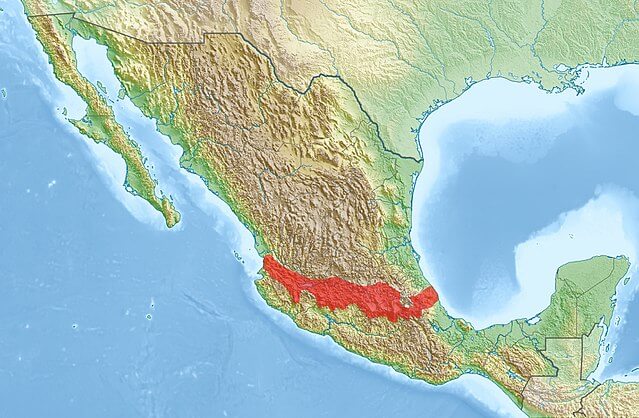
Map depicting the location of the Trans-Mexican Volcanic Belt in Mexico.
Distinctive Landscapes
South of the Trans-Mexican Volcanic Belt lies the Balsas Depression, characterized by its hot, arid environment. The depression, named after the major river in the region, features small basins interspersed with hilly outcrops, contributing to its unique physical topography.
Noteworthy Peaks
Within this volcanic realm, several towering peaks capture the essence of Mexico's geological grandeur. Pico de Orizaba, the highest point, stands proudly at 5,675 meters (18,620 feet), followed by Nevado de Colima (4,339 meters or 14,236 feet), Parícutin (2,774 meters or 9,101 feet), Nevado de Toluca (4,577 meters or 15,016 feet), Popocatépetl (5,452 meters or 17,887 feet), Iztaccíhuatl (5,286 meters or 17,343 feet), Matlalcueitl (4,461 meters or 14,636 feet), Cofre de Perote (4,282 meters or 14,049 feet), and Sierra Negra (4,580 meters or 15,030 feet).
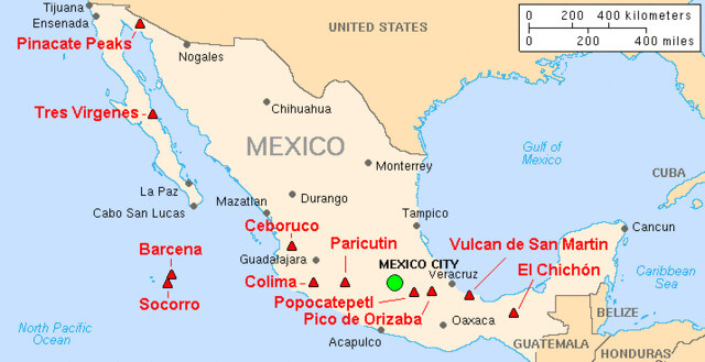
Map depicting the major active volcanoes of Mexico. From west to east, volcanoes part of the volcanic belt are Nevado de Colima, Parícutin, Popocatépetl, and Pico de Orizaba.
Scientific Significance
The Trans-Mexican Volcanic Belt is a living laboratory for geologists and researchers. It offers insights into the complex geological processes associated with plate tectonics, volcanic activity, and landform evolution. Understanding this volcanic belt's dynamics is crucial for unraveling Earth's past and predicting and mitigating geological hazards.
Conclusion
In conclusion, the Trans-Mexican Volcanic Belt emerges as a captivating geological tapestry, weaving together tectonic intricacies, ecological wonders, and distinctive landscapes. Its towering peaks and active volcanoes narrate Earth's geological evolution saga, inviting exploration and scientific inquiry.