The Puerto Rico Trench: Unveiling the Depths
The Puerto Rico Trench is an impressive geological feature beneath the Caribbean Sea and the Atlantic Ocean. It is an underwater depression situated on the border between the two vast bodies of water and is notable for its depth and complexity. The deepest point in the Atlantic Ocean is at its western end.

The Puerto Rico Trench: Unveiling the Depths
The Puerto Rico Trench is an impressive geological feature situated parallel to Puerto Rico's northern coast beneath the Caribbean Sea and the Atlantic Ocean. It is an underwater depression located on the border between the two vast bodies of water and is notable for its depth and complexity. The deepest point in the Atlantic Ocean, the Milwaukee Depth, can be found at the trench's western end.
Geographical Overview
Situated parallel to the northern coast of Puerto Rico and approximately 75 miles (120 kilometers) north, the Puerto Rico Trench spans about 1,090 miles (1,750 kilometers) in length and 60 miles (100 kilometers) in width. At its western end lies the deepest point in the Atlantic Ocean, the Milwaukee Depth, plunging to a staggering 27,493 feet (8,380 meters) and located about 100 miles (160 kilometers) northwest of Puerto Rico.
On December 19, 2018, the DSSV Pressure Drop utilized advanced technology, including the Kongsberg EM124 multibeam sonar, to identify the trench's deepest point. The manned submersible Deep-Submergence Vehicle DSV Limiting Factor further verified this depth, providing valuable insights into the trench's topography.
Geological Complexity and Plate Boundaries
The Puerto Rico Trench is intricately linked to the complex transition between the Lesser Antilles subduction zone to the south and a major transform fault zone or plate boundary extending westward between Cuba and Hispaniola through the Cayman Trough to the coast of Central America.
This oceanic trench exists at a boundary where the Caribbean Plate and the North American Plate interact. The Caribbean Plate shifts eastward, while the North American Plate moves westward. The trench witnesses a unique scenario where the North American Plate undergoes oblique subduction by the Caribbean Plate, contributing to the trench's geological complexity.
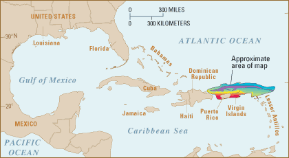
Location map of the Puerto Rico trench (USGS).
Geohazards and Earthquake Risks
While the trench experiences only a small subduction component, the Lesser Antilles subduction zone to the southeast results in active volcanic activity. The island arc from Puerto Rico to the coast of South America frequently witnesses volcanic eruptions. However, Puerto Rico, the United States Virgin Islands, the British Virgin Islands, and the Dominican Republic do not have active volcanoes.
Despite the absence of active volcanoes, the region remains at risk from earthquakes and tsunamis. The Puerto Rico Trench has the potential to generate earthquakes greater than magnitude 8.0, posing a significant geohazard to the surrounding areas.
Gravitational Anomalies and Navigational Challenges
Beneath the Puerto Rico Trench lies a dense mass that exerts a gravitational pull on the ocean's surface, causing it to dip. This phenomenon not only influences the sea but also has a notable impact on navigational instruments, affecting their accuracy.
According to NASA, the gravitational anomalies beneath the trench create challenges for navigational accuracy, emphasizing the multifaceted nature of this geological site.
Conclusion
The Puerto Rico Trench, with its mesmerizing depths and geological intricacies, invites exploration and study. This trench showcases the Earth's dynamic processes in a unique underwater landscape, from subduction dynamics to seismic risks and gravitational anomalies. As scientists delve deeper into its mysteries, the Puerto Rico Trench continues to unveil the complexities beneath the ocean's surface.
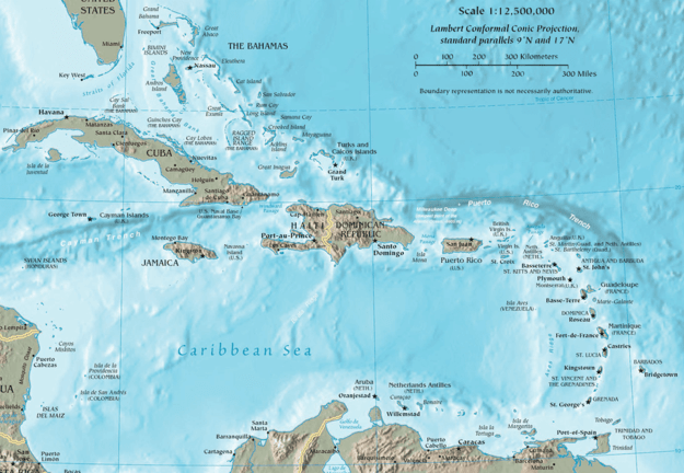
Map of the Caribbean, depicting the location of the Puerto Rico Trench.