Kick 'em Jenny: Exploring the Depths of an Active Submarine Volcano
Kick 'em Jenny is an active submarine volcano in the Grenadines that rises above the surrounding floor of the Caribbean Sea. As the southernmost active volcano in the Lesser Antilles volcanic arc and the only active submarine volcano, it stands as a unique geological wonder beneath the sea's surface.
 https://www.flickr.com/photos/84108876@N00/3704000284")
Kick 'em Jenny: Exploring the Depths of an Active Submarine Volcano
Kick 'em Jenny, the enigmatic submarine volcano, lurks approximately 8 kilometers (5 miles) north of Grenada and 8 kilometers (5 miles) west of Ronde Island in the Grenadines. As the southernmost active volcano in the Lesser Antilles Volcanic Arc, it stands as a unique geological wonder beneath the surface of the Caribbean Sea.
Towering Depths
Rising about 1,300 meters (4,265 feet) above the Caribbean Sea floor, Kick 'em Jenny boasts a summit crater measuring approximately 100 meters (330 feet) in diameter. Despite its concealed nature, this underwater giant makes its presence felt, with its summit lying 180 meters (600 feet) below sea level.
Tectonic Ballet
Situated on the steep inner western slope of the Lesser Antilles ridge, Kick 'em Jenny owes its existence to the subduction of the South American Plate beneath the Caribbean Plate. This intricate dance of tectonic forces has given rise to the only active submarine volcano in the region.
Eruptions and Discoveries
The volcanic secret of Kick 'em Jenny remained shrouded until 1939, when it was first identified. Since then, it has erupted at least 13 times, with the most recent event occurring in April 2017. Based on visual accounts, the 1939 eruption stands out as the most formidable in the volcano's eruptive history.
Explosive Power and Hazards
The eruptions of Kick 'em Jenny are characterized by explosive power, capable of generating tsunamis and ash clouds that pose significant risks. The volcano is a spectacle and a potential source of volcanic hazards, including lava flows, mudflows, and pyroclastic flows. The lava produced mirror compositions found on neighboring islands, primarily olivine basalts and basaltic andesites.
Maritime Exclusion Zone
The volcano's strategic location on the shipping route from St Vincent to Grenada makes it a potential hazard for maritime activities. To address this, the Seismic Research Centre of the University of the West Indies, Trinidad and Tobago, monitors a Maritime Exclusion Zone. This zone, typically with a radius of 1.5 kilometers (1 mile), expands to 5 kilometers (3 miles) during heightened seismic activity. Navigational charts mark this exclusion zone as a crucial safeguard for ships and fisheries in the vicinity.
In conclusion, Kick 'em Jenny stands as a submerged force, weaving its geological narrative beneath the azure waters of the Caribbean. From its tectonic origins to explosive eruptions and the ever-watchful exclusion zone, this submarine volcano continues to captivate scientists and mariners alike, reminding us of the dynamic forces that shape the planet.
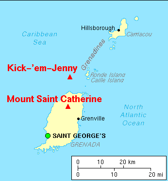
Map depicting the location of the major volcanoes of Grenada and vicinity, West Indies.