The Middle America Trench: Where Ocean Floors Collide and Continents Rise
The Middle America Trench represents one of Earth's most dynamic subduction zones, where massive tectonic plates converge in a process that has shaped the region's landscape. This extensive underwater canyon naturally divides into two distinct segments: the Acapulco and Guatemala trenches.

Tectonic Theater: The Middle America Trench and Its Geological Drama
Beneath the azure waters of the eastern Pacific Ocean, a colossal geological drama unfolds daily along the coasts of Mexico and Central America. The Middle America Trench, also known as the Central America Trench or Mid-American Trench, represents one of Earth's most dynamic subduction zones, where massive tectonic plates converge in a process that has shaped the region's landscape for millions of years. This extensive underwater canyon naturally divides into two distinct segments: the northern Acapulco Trench following Mexico's curved coastline, and the southern Guatemala Trench extending in a more linear fashion toward Costa Rica.
A Submarine Canyon of Continental Proportions
Stretching like an underwater scar from central Mexico to Costa Rica, the Middle America Trench extends approximately 2,750 kilometers (1,708 miles) along the ocean floor. This immense geological feature encompasses a total area of 96,000 square kilometers (37,065 square miles), making it comparable in size to the entire country of South Korea. At its most profound depths, the trench plunges to 6,689 meters (21,945 feet) below sea level, earning its position as the 18th deepest oceanic trench on our planet.
The trench's impressive dimensions tell only part of its story. This submarine canyon represents the active boundary where several of Earth's major tectonic plates engage in a perpetual dance of collision and subduction. The smaller Rivera Plate, along with the Cocos Plate and portions of the Nazca Plate, slides beneath the much larger North American Plate and Caribbean Plate in a process that generates tremendous geological forces.
The Architecture of Tectonic Collision
The Middle America Trench functions as nature's conveyor belt, where oceanic crust formed at mid-ocean ridges travels thousands of kilometers before diving back into Earth's mantle. This subduction process occurs at varying rates along the trench's length, typically ranging from 2 to 9 centimeters (0.8 to 3.5 inches) per year. While these measurements might seem insignificant in human terms, they represent enormous forces capable of building mountain ranges and triggering devastating earthquakes.
The convergence zone creates a complex underwater topography characterized by steep walls, sediment-filled basins, and fault systems that extend deep into the ocean floor. Sediments carried by rivers from the adjacent landmasses, combined with marine deposits, accumulate in the trench axis, sometimes reaching thicknesses of several kilometers. These sedimentary layers preserve a geological record spanning millions of years, offering scientists invaluable insights into past climate conditions, volcanic activity, and tectonic processes.
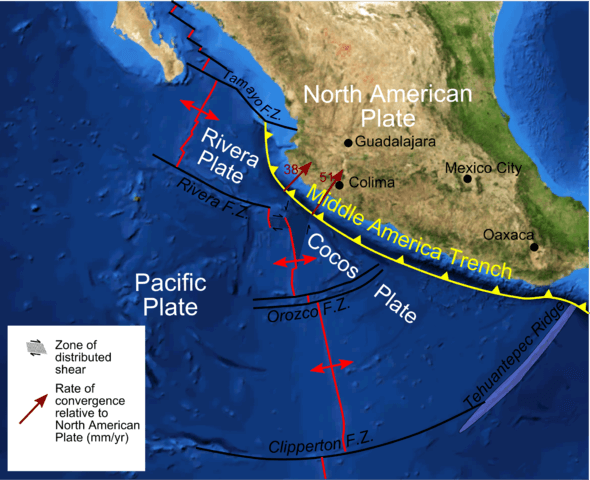
Map depicting the tectonic setting of the Middle American Trench off western Mexico.
The Dual Nature: Acapulco and Guatemala Trenches
Geographic and geological differences naturally divide the Middle America Trench into two distinct segments, each with unique characteristics that reflect the complex tectonic environment of the region. The northern section, known as the Acapulco Trench, follows the graceful curve of the Mexican coastline from Jalisco to the Tehuantepec Ridge. This portion of the trench system mirrors the continental shelf's contours and experiences different subduction dynamics compared to its southern counterpart.
The Acapulco Trench's western boundary aligns with the Tamayo Transform Fault, a significant fracture zone that connects to the East Pacific Rise spreading center. This geometric relationship influences the angle and rate at which oceanic plates descend into the mantle, creating distinctive patterns of seismic activity and crustal deformation along the Mexican coast.
In contrast, the Guatemala Trench extends southward from the Tehuantepec Ridge to the Cocos Ridge off Costa Rica's coast, following a more linear trajectory. This southern section exhibits different subduction characteristics, including variations in the descending plate's age, density, and geological composition. The Guatemala Trench correlates closely with Central America's volcanic arc, where ascending magma generated by the subduction process creates the region's impressive chain of active volcanoes.
The Landward Perspective: Continental Consequences
The effects of the Middle America Trench extend far beyond the ocean floor, profoundly influencing the geological and topographical development of the adjacent continents. The landward division between the northern and southern trench segments occurs along the Polochic-Motagua fault system, a major strike-slip fault zone that marks the boundary between the North American and Caribbean plates. Interestingly, this continental boundary lies approximately 400 kilometers (249 miles) east of its oceanic counterpart, illustrating the complex three-dimensional nature of plate tectonic interactions.
The subduction process generates intense heat and pressure that partially melts the descending oceanic crust, creating magma that rises through the overlying continental plate. This mechanism drives the formation of Central America's volcanic arc, a chain of stratovolcanoes that includes some of the region's most prominent peaks. From Mexico's Pico de Orizaba to Costa Rica's Arenal, these volcanic edifices represent the surface expression of deep-seated processes occurring hundreds of kilometers beneath the ocean floor.
Seismic Legacy and Natural Hazards
The Middle America Trench's role as an active convergent margin makes it one of the world's most seismically active regions. The constant motion of tectonic plates generates stress that periodically releases through earthquakes ranging from minor tremors to devastating megathrust events. Historical records document numerous significant earthquakes along the trench system, including events exceeding magnitude 8.0 that have caused substantial damage to coastal communities.
The 1985 Michoacán earthquake, which devastated Mexico City despite occurring 350 kilometers (217 miles) away, exemplifies the far-reaching impact of trench-related seismic activity. The earthquake's energy traveled through the North American Plate's crystalline structure, amplifying in the soft lake bed sediments beneath Mexico's capital and causing catastrophic building collapses.
Beyond earthquakes, the trench system poses tsunami risks to Pacific-facing coastlines. Submarine landslides, underwater volcanic eruptions, or major seismic events can displace enormous volumes of water, generating waves that travel across ocean basins at jet aircraft speeds. Coastal communities from Mexico to Costa Rica maintain tsunami early warning systems and evacuation protocols designed to mitigate these marine hazards.
Biological Oasis in the Deep
Despite the extreme conditions of crushing pressure, perpetual darkness, and low temperatures, the Middle America Trench supports remarkable biological communities adapted to deep-sea life. Chemosynthetic bacteria form the foundation of these ecosystems, deriving energy from chemical reactions involving hydrogen sulfide and methane seeping from the ocean floor. These microorganisms support diverse communities, including tube worms of the genus Riftia, deep-sea clams (Calyptogena spp.), and various species of amphipods and polychaete worms.
Cold seeps along the trench axis create localized areas of enhanced biological activity where hydrocarbons and other reduced chemicals provide energy sources for specialized organisms. These communities represent evolutionary laboratories where life forms have adapted to conditions vastly different from those found in surface environments, offering insights into the potential for life in extreme environments both on Earth and potentially on other planets.
Scientific Window into Earth's Interior
Modern research vessels equipped with deep-sea submersibles, remotely operated vehicles, and sophisticated sonar systems have revolutionized our understanding of the Middle America Trench. Multi-beam bathymetry reveals detailed seafloor topography, while seismic reflection profiles penetrate deep into the sedimentary layers and underlying crustal structure. These technological advances allow scientists to create three-dimensional models of the subduction process and monitor real-time changes in the trench environment.
International research collaborations continue to investigate fundamental questions about subduction zone dynamics, including the factors controlling earthquake magnitude and frequency, the mechanisms of magma generation, and the long-term evolution of convergent margins. The Middle America Trench serves as a natural laboratory where theories about plate tectonics can be tested and refined through direct observation and measurement.
The ongoing study of this remarkable geological feature enhances our ability to assess natural hazards, understand the impacts of climate change on ocean systems, and appreciate the profound connections between deep Earth processes and surface environments. As technology advances and research capabilities expand, the Middle America Trench will undoubtedly continue revealing secrets about our planet's dynamic interior and the forces that shape the world we inhabit.
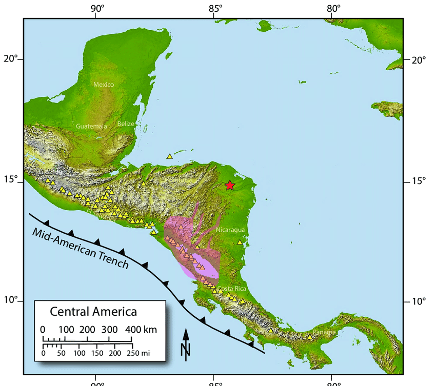
Map depicting the Central American Volcanic Arc with the Middle American Trench to the southwest.