The Cayman Trench and Cayman Ridge: Exploring the Depth
The Cayman Trench is a submarine trench on the floor of the western Caribbean Sea between Jamaica and the southeastern tip of Cuba. The Cayman Ridge is an undersea mountain range on the northern margin of the Cayman Trough and includes the Cayman Islands.

The Cayman Trench and Cayman Ridge: Exploring the Depth
The Caribbean Sea contains a remarkable feature beneath its surface, known as the Cayman Trench and the Cayman Ridge. Discovering the secrets of these geological wonders requires a deep dive into the western Caribbean, where extreme temperatures and distinct formations challenge traditional knowledge of the ocean floor.
Cayman Trench: The Abyss of the Caribbean
The Cayman Trench, also known as the Cayman Trough, Bartlett Deep, or Bartlett Trough, is a submarine trench between Jamaica and the southeastern tip of Cuba. It is the deepest point in the Caribbean Sea and plummets to a maximum depth of 7,686 meters (25,217 feet). Its role as a tectonic boundary separating the North American Plate and the Caribbean Plate makes it even more intriguing.
Geographical Features
Stretching from the Windward Passage to the Sierra Maestra of Cuba and beyond towards Guatemala, the Cayman Trench follows a relatively narrow path, trending east-northeast to the west-southwest. The eastern section, known as the Gonâve Microplate, extends from the spreading ridge to the island of Hispaniola.
Extreme Conditions
The Cayman Trench experiences near-freezing temperatures at its deepest points. Paradoxically, within this abyss, some of the world's hottest and deepest deep-sea vents are discovered, reaching temperatures of up to 400 °C (752 °F) and residing 5 kilometers (3 miles) below the surface.
Cayman Ridge: The Submerged Mountain Range
Adjacent to the Cayman Trench lies the Cayman Ridge, an undersea mountain range tracing the northern margin of the trench in the Caribbean Sea. Extending approximately 1,500 kilometers (930 miles) from the Sierra Maestra in southern Cuba to the Misteriosa Bank in the west, the Cayman Ridge also encompasses the Cayman Islands.
Formation and Geological Evolution
The Cayman Ridge owes its existence to the dynamic interplay between the North American and Caribbean plates. Initially formed as an island arc during the Paleocene and Eocene epochs, it emerged when the Cayman Trench served as a subduction zone. Over time, this subduction zone transformed into a transform fault zone with a pull-apart basin, leading to a decline in volcanism along the entire length of the arc. Consequently, the Cayman Ridge stands today as an inactive volcanic zone.
Landmarks and Outcrops
Notable landmarks dotting the Cayman Ridge include the Grand Cayman, Cayman Brac, and Little Cayman Islands. These islands are visible reminders of the geological processes that shaped the region and offer a glimpse into its intricate history.
Conclusion
The Cayman Trench and Cayman Ridge are fascinating geological features in the Caribbean. Their deep trenches and towering ridges showcase a story of transformation. These underwater marvels have captured the imagination of scientists and enthusiasts alike, inviting further exploration. They have seen a range of activity, from volcanic eruptions in the past to a calm present. They continue to captivate, paving the way for uncovering the mysteries hidden beneath the ocean's surface.
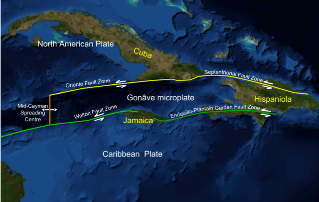
Map depicting the Mid-Cayman spreading center as part of the Cayman Trough on the western edge of the Gonâve Microplate.