The Altiplano—Puna Volcanic Complex: Unveiling Geological Marvels in South America
The Altiplano—Puna Volcanic Complex covers 50,000 square kilometers and spans Argentina, Bolivia, and Chile. It was formed when the Nazca Plate subducted beneath the South American Plate and boasts diverse volcanic features. The complex also has the largest active magma reservoir on Earth.


The Altiplano—Puna Volcanic Complex: Unveiling Geological Marvels in South America
The Altiplano—Puna volcanic complex (APVC) is a testament to the awe-inspiring geological processes shaping the southern portion of the Altiplano—Puna plateau in the central Andes. Spanning parts of Argentina, Bolivia, and Chile, this expansive volcanic field covers approximately 50,000 square kilometers (19,000 square miles) between the Atacama basin and the Altiplano, bordered by the Bolivian Cordillera Real to the east and the Cordillera Occidental to the west.
Formation and Tectonic Setting
The APVC emerged over several million years due to the subduction of the Nazca Plate beneath the South American Plate, occurring at an angle of nearly 30°. This complex interplay of tectonic forces has given rise to diverse volcanic features and phenomena, making the APVC a region of considerable scientific interest.
Delamination of the crust beneath the northern Puna and the southern Altiplano has formed the Altiplano—Puna magma body, a colossal active magma reservoir located at depths of approximately 10 to 20 kilometers (6 to 12 miles). This magma body, often called the Altiplano—Puna low-velocity zone, is Earth's largest known active magma reservoir.
The southward migration of the Juan Fernández Ridge has played a crucial role in regional variations in volcanic activity. This movement results in the steepening of the subducting plate behind the ridge, leading to decompression melting. About 25 to 33% of the generated melts erupt to the surface as ignimbrites, distinctive volcanic rock deposits.
Notable Geothermal Fields
El Tatio
El Tatio, located in the Andes Mountains of northern Chile at an elevation of 4,320 meters (14,173 feet), is the third-largest geyser field globally and the largest in the Southern Hemisphere. This geothermal field, a major tourist attraction, features numerous geysers, hot springs, and sinter deposits. It lies at the western foot of a series of stratovolcanoes, part of the Central Volcanic Zone and the broader APVC.
Sol de Mañana
In southwestern Bolivia, the geothermal field of Sol de Mañana extends over 10 square kilometers (4 square miles) at an altitude of 4,800 to 5,000 meters (15,750 to 16,400 feet). It is characterized by intense volcanic activity and boasts sulfur springs, mud lakes, and steam pools with boiling mud. This field is part of the geothermal system associated with the APVC's volcanic system.
Cerro Guacha
Cerro Guacha, a caldera in southwestern Bolivia, is linked to the APVC and the Central Volcanic Zone. Two major ignimbrites, the Guacha ignimbrite and the Tara ignimbrite, erupted from Cerro Guacha. The larger caldera spans dimensions of 60 by 40 kilometers (37 by 25 miles), reflecting the extended volcanic activity in the region.
Pastos Grandes
Pastos Grandes, a remote caldera and crater lake in Bolivia's Sud Lipez region, is an integral part of the APVC within the Central Volcanic Zone. This caldera, identified through satellite imagery, has erupted various ignimbrites throughout its history. The lakes within Pastos Grandes, fed by hot springs, contain dissolved minerals, including lithium.
Cerro Chao
Cerro Chao, a lava flow complex associated with the Cerro del León volcano, is the most significant known Quaternary silicic volcano body in the APVC. Formed through multiple eruptions, its extensive lava flows bear witness to the recent geological activity in the region.
La Pacana
La Pacana is a supervolcano in northern Chile's Antofagasta Region. It forms part of the APVC in the Central Volcanic Zone. Approximately 3 to 4 million years ago, La Pacana erupted the colossal Atana ignimbrite, the fifth-largest explosive eruption known. The caldera's unique geological features provide crucial insights into the Earth's volcanic history.
Cerro Chascon-Runtu Jarita
Cerro Chascon-Runtu Jarita, a complex of lava domes within the Pastos Grandes caldera, adds to the APVC's geological diversity. While likely unrelated to the caldera, this complex is part of the recent phase of activity in the Altiplano—Puna volcanic complex.
Scientific Significance and Challenges
The APVC's vast expanse and geological intricacies pose opportunities and challenges for scientific exploration. The colossal Altiplano—Puna magma body beneath the surface beckons researchers to unravel its mysteries, providing a unique window into the Earth's underground processes.
The region's dry climate and high-altitude location, characteristic of the Atacama Desert, have shielded the deposits of APVC volcanism from extensive erosion. Nevertheless, limited erosion presents challenges, as it restricts the exposure of buried layers and structures that could offer valuable insights into the region's geological evolution.
In conclusion, the Altiplano—Puna Volcanic Complex is a geological marvel, weaving together the intricate dance of tectonic plates, magma reservoirs, and volcanic activity. From the steaming geysers of El Tatio to the ancient supervolcano of La Pacana, each facet of this volcanic complex adds to our understanding of the dynamic forces shaping the Earth's surface. As scientific exploration continues, the APVC remains a captivating frontier, promising new revelations about our planet's geological history.
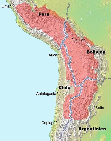
Map showing the location (in red) of the Altiplano—Puna plateau in South America.