Cordillera de Talamanca: A Biodiversity Haven in Central America
The Cordillera de Talamanca, a magnificent mountain range in southern Costa Rica that extends into western Panama, is one of Central America's most ecologically significant and biologically diverse regions. It is renowned for its rugged terrain, towering peaks, and unique ecosystems.
 - by Bernal Saborio (CC BY-SA 2.0) https://www.flickr.com/photos/44073224@N04/29952523135")

 - via Wikimedia Commons")
 - via Wikimedia Commons")
 https://www.flickr.com/photos/travicted/35537849712")
. Mountainous massif that is part of the westernmost foothills of the Talamanca Mountain Range - via Wikimedia Commons")
Talamanca: The Heart of Central America's Ecological and Cultural Heritage
The Cordillera de Talamanca, a majestic mountain range in southern Costa Rica extending into western Panama, is one of Central America's most ecologically significant and biologically diverse regions. Renowned for its rugged terrain, towering peaks, and unique ecosystems, this mountain range is a natural barrier and a sanctuary for countless endemic species. With its rich biodiversity, varied climates, and cultural heritage, the Cordillera de Talamanca is a living testament to the region's natural beauty and ecological importance.
Geographic Overview
Stretching southwest of Costa Rica's capital, San José, and running parallel to the Pacific coastline, the Cordillera de Talamanca extends southeastward into Panama, forming a natural divide between Costa Rica's central highlands and the coastal lowlands. The range's elevation varies dramatically, rising from sea level on the Caribbean side to over 3,650 meters (12,000 feet) at its highest points before descending to the Valle General on the Pacific side.
Mount Chirripó, the highest peak in the range, reaches an elevation of 3,819 meters (12,530 feet). On clear days, this vantage point offers breathtaking views of both the Caribbean Sea and the Pacific Ocean. Other notable summits include Cerro de la Muerte, which stands at 3,451 meters (11,322 feet), Cerro Kamuk, and Cerro Terbi. These peaks contribute to the Cordillera de Talamanca's reputation as a formidable and awe-inspiring landscape.
Geological Formation and History
The Cordillera de Talamanca was once a volcanic island that had been formed millions of years ago. Its current structure results from tectonic uplift, which separates it from other mountain ranges in Central America. This isolation has allowed the development of many endemic plant and animal species, often exhibiting affinities with species found in the Andes. The geological history of the Cordillera de Talamanca contributes to its complex topography and rich biodiversity.
Ecosystems and Climate
The Cordillera de Talamanca's varying altitudes and climates create a mosaic of ecosystems, ranging from tropical rainforests at lower elevations to cloud forests, highland páramo, and alpine grasslands at higher altitudes. The lower slopes are covered in dense tropical rainforests, rich with diverse plant and animal life. As one ascends, the rainforests give way to cloud forests, characterized by high humidity, frequent mist, and a rich array of epiphytes, mosses, and ferns.
At the highest elevations, the landscape transitions into páramo vegetation, a high-altitude grassland reminiscent of the páramo found in the Andes. These areas are often covered in small shrubs, grasses, and hardy plants adapted to cold and wet conditions. The Cordillera de Talamanca experiences various climatic conditions, from hot temperatures in the lowlands to cold, moist, and occasionally freezing conditions in the high-altitude summit areas. The driest months are typically from December through March.
Biodiversity and Endemic Species
The Cordillera de Talamanca is recognized as a biodiversity hotspot, harboring exceptional species richness and endemism levels. The range is home to numerous endemic plants, amphibians, reptiles, and bird species. Its diverse habitats support a variety of wildlife, including many rare and endangered species.
Notable fauna include large mammals such as Baird's Tapir, Puma, and Jaguar, which find refuge in the region's dense forests. Birdlife is equally impressive, with species like the Resplendent Quetzal, known for its vibrant plumage, thriving in the cloud forests. Such a wide variety of species makes the Cordillera de Talamanca crucial for ongoing conservation efforts.
Conservation and Protection
The ecological significance of the Cordillera de Talamanca has led to the establishment of numerous protected areas, including national parks, wildlife refuges, and indigenous reservations. One of the most prominent is the Talamanca Range-La Amistad Reserves / La Amistad National Park, a UNESCO World Heritage site that spans the border between Costa Rica and Panama. This park is recognized as the first bi-national biosphere reserve and plays a vital role in protecting the region's biodiversity and ecosystems.
Despite its protected status, the Cordillera de Talamanca faces several environmental challenges. Illegal logging, habitat fragmentation, and the impacts of climate change threaten the delicate balance of its ecosystems. Ongoing conservation efforts are essential to safeguard the unique habitats and species that call this mountain range home.
Cultural Heritage
In addition to its natural wonders, the Cordillera de Talamanca is home to Indigenous communities whose cultural heritage is deeply intertwined with the landscape. These communities, including the Bribri and Cabécar, have lived in harmony with their environment for centuries, preserving traditional knowledge and practices that contribute to conserving the region's biodiversity. Indigenous reservations within the Cordillera de Talamanca serve as cultural and ecological sanctuaries, highlighting the importance of integrating cultural preservation with environmental protection.
Conclusion
The Cordillera de Talamanca, with its dramatic landscapes, rich biodiversity, and cultural heritage, is a jewel of Central America. Its towering peaks, ranging from tropical rainforests to alpine páramo, support an astonishing variety of plant and animal species, many of which are found nowhere else on Earth. The Cordillera de Talamanca exemplifies the importance of protecting our planet's natural treasures as a UNESCO World Heritage site and a bi-national biosphere reserve. By continuing to promote sustainable practices and support conservation initiatives, this unique mountain range will remain a vital sanctuary for biodiversity and a testament to the enduring relationship between nature and culture.
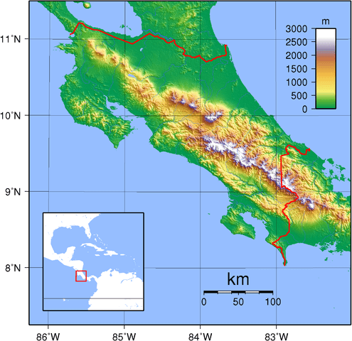
Topographic map of Costa Rica depicting the Talamanca range in southeastern Costa Rica and western Panama.