Cordillera de Guanacaste: Costa Rica's Volcanic Highlands
The Cordillera de Guanacaste in northwestern Costa Rica is a volcanic mountain range known for its dramatic peaks, rich biodiversity, and significant geological history. Part of the Central America Volcanic Arc, it features volcanic activity, geothermal energy potential, and protected natural areas.
 https://www.flickr.com/photos/spinfly/16303174461")


 https://www.flickr.com/photos/88273881@N00/14657903407")
The Cordillera de Guanacaste: A Natural Divide Shaping Costa Rica's Landscape
The Cordillera de Guanacaste, located in northwestern Costa Rica near the border with Nicaragua, is a prominent volcanic mountain range known for its dramatic peaks, rich biodiversity, and significant geological history. As part of the larger Central America Volcanic Arc, this range offers a unique landscape of volcanic activity, geothermal energy potential, and protected natural areas. The Cordillera de Guanacaste is vital to Costa Rica's environmental and cultural heritage, attracting researchers, tourists, and conservationists alike.
Geographic Overview
Extending for approximately 113 kilometers (70 miles) in a northwest-southeast direction, the Cordillera de Guanacaste forms part of the southern region of the Continental Divide. This mountain range is characterized by volcanic peaks, ridges, and valleys that define its rugged terrain. The highest point in the Cordillera de Guanacaste is the dormant Miravalles Volcano, which rises to 2,028 meters (6,654 feet) above sea level. The range serves as a natural divide, influencing the climate and hydrology of the surrounding regions.
Division of the Cordillera de Guanacaste
The Cordillera de Guanacaste is divided into two distinct sections:
La Cordillera Volcánica: This section consists of a series of volcanic structures that begin with the Orosí Volcano and extend southeastward to the Arenal Volcano. The volcanic peaks in this section are primarily complex stratovolcanoes, characterized by their layered structure of hardened lava and volcanic ash.
La Sierra Minera: This area comprises depressions between the Arenal and Tapezco regions. Although less prominent in terms of volcanic activity, this section contributes to the geological diversity of the Cordillera de Guanacaste.
Notable Peaks and Volcanic Activity
The Cordillera de Guanacaste features several notable volcanic peaks, each with its unique characteristics:
Miravalles Volcano: The highest peak in the range, at 2,028 meters (6,654 feet). It is a dormant volcano with geothermal potential.
Rincón de la Vieja Volcano: Another significant peak at 1,916 meters (6,286 feet). This active stratovolcano is known for its geothermal activity, hot springs, and fumaroles.
Tenorio Volcano: Also reaching 1,916 meters (6,286 feet), this volcano is famous for the Río Celeste, a river known for its striking turquoise color, which is a result of volcanic minerals.
Orosí Volcano: Rising to 1,659 meters (5,443 feet), Orosí is one of the older volcanic formations in the range.
Arenal Volcano: At 1,670 meters (5,480 feet), Arenal is one of Costa Rica's most active volcanoes. Its notable eruption in 1968 caused widespread destruction, impacting two villages and killing approximately 100,000 head of cattle. Today, Arenal is a popular tourist destination, known for its conical shape and ongoing volcanic activity.
Hydrology
The Cordillera de Guanacaste plays a crucial role in the region's hydrology, with rivers originating from its slopes and draining into the Caribbean Sea and the Pacific Ocean. Key rivers that flow toward the Caribbean include the Guacalito and Zapote, while those draining into the Pacific include the Blanco, Tenorio, Martirio, Corobiá, and San Lorenzo. These rivers provide essential water resources for agriculture, hydroelectric power generation, and ecological sustenance in the region.
Protected Areas and Conservation
The Cordillera de Guanacaste is home to several protected areas, emphasizing the importance of conservation and biodiversity. Significant protected zones include:
Guanacaste National Park: This park protects large tracts of tropical dry forest, a unique ecosystem in Costa Rica, as well as cloud forests and volcanic landscapes. It is part of the larger Area de Conservación Guanacaste.
Area de Conservación Guanacaste World Heritage Site: Inscribed by UNESCO in 1999, this conservation area is recognized for its biodiversity and the successful restoration of degraded lands. It includes the Santa Rosa National Park and Rincón de la Vieja National Park, among others.
These protected areas serve as sanctuaries for numerous plant and animal species, including endemic or endangered ones. They also play a crucial role in maintaining the region's ecological connectivity and environmental health.
Geothermal Energy Potential
The volcanic activity within the Cordillera de Guanacaste has made the region a focal point for geothermal energy exploration and development. The area's geothermal fields are harnessed to generate electricity, contributing to Costa Rica's commitment to renewable energy sources. Geothermal energy from this region supports a portion of the country's energy needs and is exported to neighboring countries such as Nicaragua and Panama. The presence of geothermal power plants near the Miravalles and Rincón de la Vieja volcanoes underscores the potential for sustainable energy development.
Conclusion
The Cordillera de Guanacaste is a remarkable mountain range that showcases the dynamic interplay of volcanic activity, ecological diversity, and conservation efforts. Its towering peaks, rich ecosystems, and geothermal potential make it vital to Costa Rica's natural and cultural heritage. As a region of both environmental and economic significance, the Cordillera de Guanacaste exemplifies the importance of preserving natural landscapes while exploring sustainable resource utilization. By continuing to protect and study this unique mountain range, Costa Rica can maintain its role as a leader in biodiversity conservation and renewable energy development.
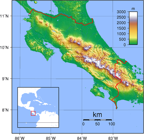
Topographic map of Costa Rica depicting the Cordillera de Guanacaste in northwestern Costa Rica.