The Andes Mountains and the Andean Region: A Comprehensive Exploration
The Andes Mountains are the most extended continental mountain range on Earth. They form an unbroken highland along the western coast of the South American continent, stretching from Caribbean Venezuela in the north to the Atacama Desert and south to the cold, windy, and wet Cape Horn.
 https://www.flickr.com/photos/79721788@N00/7914098320")
 https://www.flickr.com/photos/23729107@N04/2986037197/in/photostream/")
 https://www.flickr.com/photos/zrimshots/3406061166/in/album-72157616252515047/")
")
 https://www.flickr.com/photos/41111966@N04/49180025128")
 (CC BY 3.0)")
")
")
")
 (CC BY 3.0)")
 https://www.flickr.com/photos/72482589@N07/29526977937")
The Andes Mountains and the Andean Region: A Comprehensive Exploration
The Andes Mountains, or Cordillera de Los Andes, stand as the most extended continental mountain range globally, tracing a majestic path along the western coast of the South American continent for over 7,000 kilometers (4,350 miles). This geographical marvel not only separates a narrow western coastal region from the rest of the continent but also serves as the highest mountain range outside Asia. The following comprehensive exploration delves into the geological origins, diverse geography, and rich ecological expanse of the Andes Mountains and the Andean region.
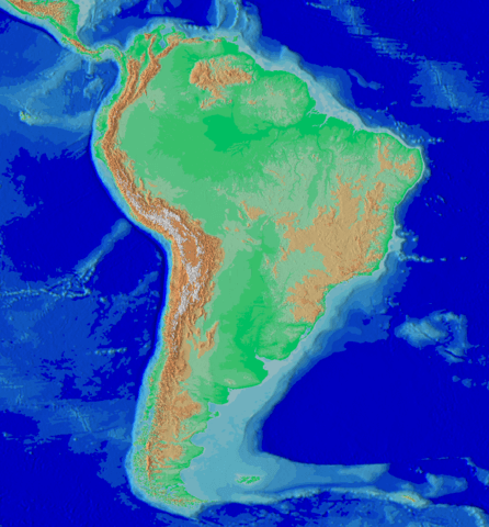
South America topographic map, Andes system along the western coast.
Geology of the Andes
Origins and Plate Tectonics
The Andes are a product of Mesozoic-era orogenesis, forming an imposing belt of mountains along the Pacific Ring of Fire. Plate tectonics, specifically the subduction of oceanic crust beneath the South American Plate, plays a pivotal role in shaping this extraordinary landscape. The convergence of the Nazca and South American plates at the Peru-Chile oceanic trench is a defining feature, leading to the ongoing orogenic events responsible for the Andes' rise.
The compression of the western rim of the South American Plate due to the subduction of the Nazca Plate and the Antarctic Plate is the primary cause behind the elevation of the Andes range. This tectonic interplay results in a dynamic region marked by frequent minor to major earthquakes and volcanic eruptions.
Volcanic Wonders
The Andes claim some of the world's highest volcanoes, adding to the region's geological significance. Ojos del Salado, situated on the Chile-Argentina border, reaches an impressive 6,893 meters (22,615 feet). Cotopaxi, the second-highest summit in Ecuador at 5,897 meters (19,347 feet), is one of the highest active volcanoes globally, contributing to the dynamic geological processes that continue to shape the Andes.
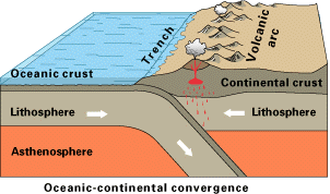
Simplified sketch of the tectonic forces along most of the Andes.
Geography of the Andes: Extensive Reach and Continental Backbone
Extending through seven countries—Venezuela, Colombia, Ecuador, Peru, Bolivia, Chile, and Argentina—the Andes Mountains play a crucial role in shaping the topography of South America. The islands of Aruba, Bonaire, and Curaçao in the Caribbean Sea are considered submerged peaks representing the extreme northern edge of the Andes range. Geologists even contemplate the possibility of the Antarctandes, the Antarctic Peninsula cordillera, being the southernmost continuation of the Andes system in Antarctica.
The Andes Mountains are integral to the American Cordillera, forming the western "backbone" of North America, Central America, South America, and Antarctica. A vast series of plateaus crowned by towering peaks characterize this extraordinary mountain range. Mount Aconcagua, standing at 6,959 meters (22,831 feet), claims the title of the highest mountain outside Asia, proudly marking the Argentina-Chile border.
The equatorial bulge is most evident in Mount Chimborazo in the Ecuadorian Andes, as its summit is the point on Earth's surface farthest from its center. This geographical feature adds a unique dimension to the Andean landscape, contributing to its global significance.
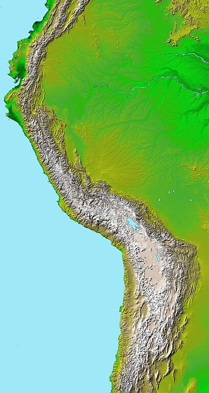
Topography of the Andes from a Digital Elevation Model.
Northern Andes
Venezuelan Andes
The Venezuelan Andes, comprising the Cordillera de Mérida and Serranía del Perijá, present a diverse landscape. The Cordillera de Mérida, often considered the proper Venezuelan Andes, is a testament to the region's geological complexity. In contrast, the Serranía del Perijá, a smaller section along the Venezuela-Colombia border, adds further nuances to the northern Andean topography.
Colombian Andes
The Colombian Andes boast three parallel mountain chains—Occidental, Central, and Oriental Cordilleras—generally trending north and south. This division contributes to the region's diverse ecosystems and geological formations.
Ecuadorian Andes
The Ecuadorian Andes, a 600-kilometer (375-mile) narrow plateau bordered by parallel chains, introduces numerous volcanoes and transversal mountain spurs, known as nudos, adding intricacy to the region's topography.
Central Andes
Peruvian Andes
The Peruvian Andes, part of the greater Andes mountain system, feature three mountain ranges, creating a landscape characterized by fertile river valleys, high plains, and deep canyons.
Bolivian Andes
The Bolivian Andes include the Cordillera Occidental, with volcanic activity, that forms the natural border with Chile, while the Cordillera Oriental, much older, extends southeastward to the Argentine border. This division contributes to Bolivia's diverse geographical and geological features.
Southern Andes
Chilean Andes and Argentine Andes
The Chilean and Argentine Andes, forming the border between these countries, represent the highest section of the mountain range. This section, marked by towering peaks and dramatic landscapes, is a testament to the Andes' geological and geographical significance.
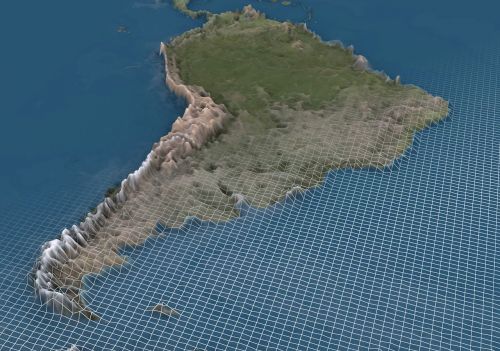
3D map depicting South America and the Andes Mountain range.
Andean Region
Environmental Contrasts
The Andean region, stretching from Caribbean Venezuela to Cape Horn, encompasses a spectrum of environments. This vast area passes through the hyperarid Atacama Desert, where tropical and temperate rainforests encircle the Northern Andes, creating abrupt environmental contrasts.
The Central Andes present a striking dichotomy. They feature arid conditions along the west coast and a steep ascent to volcanoes and glacierized massifs above 5,000 meters (16,400 feet). This abrupt transition is followed by an equally dramatic descent eastward to the lush tropical rainforests of the Amazon.
In the Southern Andes, the permanent snow line increases in elevation with decreasing latitude, introducing a line of active volcanoes, vast ice fields, and numerous lakes forming fertile valleys known as vegas. Dense and impenetrable forests grow on both sides of these cordilleras, contributing to the region's rich biodiversity.
Biodiversity: Flora and Fauna
The Andean region is a biodiversity hotspot, housing about 30,000 species of vascular plants, roughly half of which are endemic. This diversity surpasses any other hotspot globally, emphasizing the ecological significance of the Andes.
In Bolivia alone, the rich flora includes an estimated 1,950-2,500 tree species, 1,200 moss species, 1,500 fern species, 16 gymnosperm species, and 11,000 angiosperm species. Such diversity underscores the importance of the Andean region in the global context of plant life.
The fauna of the Andean region is equally varied, with approximately two-thirds of species being endemic. The area boasts almost 600 species of mammals, over 1,700 species of birds, more than 600 species of reptiles, and nearly 400 species of fish. This remarkable diversity reflects the unique ecosystems and environmental niches within the Andes.
Mammals
The vicuña and guanaco thrive in the Altiplano, while domesticated llamas and alpacas find widespread use among locals for their meat and wool. Cougars, symbolically significant in many Andean cultures, coexist with llamas, shaping the cultural landscape.
Nocturnal chinchillas, native to the Andean alpine regions, add to the region's ecological diversity. The Andean cloud forests, including the Yungas and parts of the Chocó, are home to threatened species like the mountain tapir, spectacled bear, and yellow-tailed woolly monkey.
Birds
The Andean condor, the largest flying land bird in the Western Hemisphere, graces the skies above the Andes. Numerous other birds, ranging from tinamous and geese to torrent ducks and flamingos, find habitats in lakes, rivers, and hypersaline lakes. The diverse avian population contributes to the ecological balance of the region.
Climate Variations
The Andes exhibit diverse climates, leading to the classification of three major divisions based on geographical location.
Tropical Andes
The Tropical Andes, which spans Venezuela, Colombia, Ecuador, Peru, and Bolivia, encompasses a variety of climates, contributing to the Andes' overall environmental heterogeneity.
Dry Andes
The Dry Andes extend from the Atacama Desert in northern Chile and northwestern Argentina south to latitude 35°S. They showcase arid conditions with significant temperature variations.
Wet Andes
The Wet Andes stretch from latitude 35°S south to Cape Horn at 56°S. This region has a rainy and cool climate, marked by lush landscapes and diverse ecosystems.
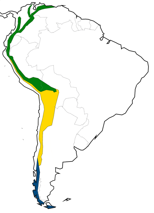
Map depicting the climatic regions of the Andes: Dry Andes in yellow, Wet Andes in blue, and Tropical Andes in green.
Conclusion
The Andes Mountains and the Andean region reveal geological marvels, diverse topography, and rich biodiversity that define this extraordinary part of the world. From Mount Aconcagua's towering peaks to the Amazon rainforest's vibrant ecosystems, the Andes showcase the intricate interplay of geological forces, climate variations, and environmental contrasts.
The Northern, Central, and Southern Andes each unveil unique features, contributing to the grand mosaic of the Andean landscape. With its astounding flora and fauna, the Andean region is a testament to life's resilience in the face of diverse climates and challenging terrains.
The Andes Mountains' towering peaks and dramatic landscapes serve as a geological wonder and a cradle of life. This comprehensive investigation offers a glimpse into the awe-inspiring complexity of the Andes and the Andean region, inviting further exploration and appreciation for the natural wonders that grace the western coast of South America.