The Chilean and Argentine Andes: A Towering Realm of Extremes and Natural Wonders
At the heart of the vast Andes Mountain-mountain system lie the Chilean and Argentine Andes, where the borders between these two nations are defined by soaring peaks, glacial valleys, and landscapes that oscillate between the arid desolation of the Dry Andes and lush, verdant splendor of the Wet Andes.

 - by sergejf, CC BY-SA 2.0 via Wikimedia Commons")
 via Wikimedia Commons")


Exploring the Grandeur of the Chilean and Argentine Andes
Stretching like a mighty spine along the western edge of South America, the Andes Mountain Range stands as a towering testament to nature's grandeur and complexity. This colossal cordillera, spanning seven countries and over 7,000 kilometers, encompasses some of the planet's most extreme and diverse landscapes. At the heart of this vast mountain system lies the Chilean and Argentine Andes, where the borders between these two nations are defined by soaring peaks, glacial valleys, and landscapes that oscillate between arid desolation and lush, verdant splendor.
The Dry Andes: A Realm of Arid Majesty
Semiarid Peaks and Enduring Glaciers
Extending from the Atacama Desert in northern Chile and northwest Argentina, the Dry Andes stretch southward to the latitudes of 35°S in Chile and 40°S in Argentina. This subregion of the Andes is characterized by a semiarid climate, where precipitation increases with elevation, yet the towering peaks and valleys remain remarkably arid.
Despite the scarcity of moisture, the Dry Andes boast some of the highest mountains in the Western Hemisphere, including the majestic Aconcagua, which reigns supreme as the highest peak in the Americas at a staggering 6,961 meters (22,838 feet). Other notable summits, such as Cerro Bonete, Galán, Mercedario, and Pissis, pierce the sky, their rugged slopes a testament to the relentless force of wind and erosion.
While the Dry Andes may seem bleak initially, life persists in this austere realm. In the valley bottoms, dwarf scrubs cling tenaciously to the parched earth. At the same time, the region's glaciers, though diminutive compared to their counterparts in the Wet Andes, offer a glimpse into the power of ice and snow. For instance, the Plomo Glacier and the Horcones Glacier, for example, stand as enduring reminders of the Andes' glacial past, when these frozen rivers of ice extended over ten times their current length during the last glacial period.
The Wet Andes: A World of Glacial Splendor
From Patagonian Peaks to Fuegian Fjords
As the Andes sweep southward from the latitudes of 35°S in Chile and 40°S in Argentina, the landscape transforms dramatically. It transitions into the Wet Andes, where moisture-laden winds from the Pacific and Atlantic Oceans collide with the towering peaks, giving rise to a world of glacial splendor.
The Wet Andes can be further divided into two distinct regions: the Patagonian Andes and the Fuegian Andes. The Patagonian Andes, rising just north of the Strait of Magellan, is a wild and rugged expanse where transverse and longitudinal depressions, ice fields, glaciers, rivers, lakes, and fjords carve through the rugged terrain. Here, the majestic Cerro San Valentin is the highest point, which soars to 4,058 meters (13,314 feet).
Farther south, the Fuegian Andes reign supreme as the southernmost subdivision of the Wet Andes and the Andes Mountain System. Beginning on Estados Island and stretching westward through Isla Grande de Tierra del Fuego, these mountains reach 2,400 meters (7,900 feet). Glacial action and relentless winds have sculpted this landscape, creating vast expanses of bare rock, peat bogs, and acidic meadows with thick humus layers and poor soil drainage.
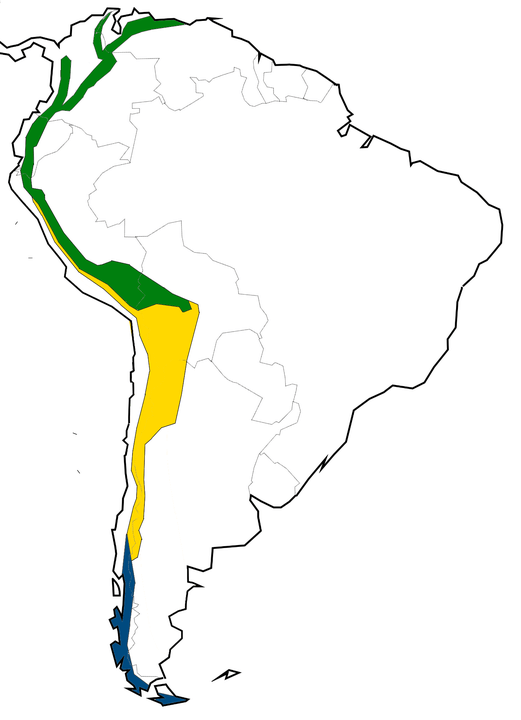
Map of the climatic regions of the Andes: Dry Andes in yellow, Wet Andes in blue and Tropical Andes in green.
Iconic Peaks and Natural Wonders
From Fitz Roy to Torres del Paine
Many iconic peaks and natural wonders beckon adventurers and nature enthusiasts in the Chilean and Argentine Andes. In the Argentine Andes, the towering Cerro Fitz Roy, also known as Cerro Chaltén, stands as a revered challenge for climbers. Its imposing granite spires reach 3,405 meters (11,171 feet) into the sky.
Across the border in Chile, the Torres del Paine National Park, a UNESCO World Heritage Site, offers a breathtaking display of nature's artistry. Here, the iconic granite towers of the Torres del Paine, rising from glacial valleys and surrounded by shimmering lakes, symbolize Patagonia's untamed beauty.
Other notable peaks and ranges within the Chilean and Argentine Andes include the volcanic Cerro Bayo, the Cordón del Azufre, the Falso Azufre, the towering Incahuasi, the glacially-carved Lastarria, the snow-capped Llullaillaco, and the mighty Marmolejo, among countless others.
Significant Peaks of the Argentine Andes
Aconcagua, 6,961 m (22,838 ft) - the highest mountain in the Americas
Cerro Bonete, 6,759 m (22,175 ft)
Galán, 5,912 m (19,396 ft)
Mercedario, 6,720 m (22,047 ft)
Pissis, 6,795 m (22,293 ft)
Significant Peaks of the Chilean Andes
Acamarachi, c.6,046 m (19,836 ft)
Cerro Castillo Dynevor, c.1,100 m (3,609 ft)
Cerro Paine Grande, 2,884 m (9,462 ft)
Cerro Macá, c.2,300 m (7,546 ft)
Monte Darwin, c.2,500 m (8,202 ft)
Monte San Valentin, 4,058 m (13,314 ft)
Mount Tarn, c.825 m (2,707 ft)
Polleras, c.5,993 m (19,662 ft)
Volcan Hudson, c.1,900 m (6,234 ft)
Significant Peaks Along the Argentina-Chile Border
Cerro Bayo, 5,401 m (17,720 ft)
Cerro Fitz Roy, 3,405 m (11,171 ft), also known as Cerro Chaltén
Cerro Escorial, 5,447 m (17,871 ft)
Cordón del Azufre, 5,463 m (17,923 ft)
Falso Azufre, 5,890 m (19,324 ft)
Incahuasi, 6,620 m (21,719 ft)
Lastarria, 5,697 m (18,691 ft)
Llullaillaco, 6,739 m (22,110 ft)
Maipo, 5,264 m (17,270 ft)
Marmolejo, 6,110 m (20,046 ft)
Nacimiento, 6,492 m (21,299 ft)
Nevado Tres Cruces, 6,748 m (22,139 ft) - south summit, III Region
Ojos del Salado, 6,893 m (22,615 ft)
Olca, 5,407 m (17,740 ft)
Sierra Nevada de Lagunas Bravas, 6,127 m (20,102 ft)
Socompa, 6,051 m (19,852 ft)
Tronador, 3,491 m (11,453 ft)
Tupungato, 6,570 m (21,555 ft)
Conclusion
The Chilean and Argentine Andes exemplify the incredible diversity and extremes that can coexist within a single mountain range. From the arid majesty of the Dry Andes, where towering peaks rise amidst semiarid valleys and small glaciers, to the glacial splendor of the Wet Andes, where the Patagonian and Fuegian regions present a tapestry of ice fields, fjords, and verdant forests, this region captivates the senses. It showcases the range of ecosystems possible within a single geographic area.
The ongoing exploration and study of the Andes highlight the fragility and resilience of the planet, emphasizing the importance of preserving these natural wonders for future generations. Whether scaling the heights of Aconcagua, trekking through the glacial valleys of Torres del Paine, or marveling at the rugged beauty of the Fuegian fjords, the Chilean and Argentine Andes offer a unique journey, illustrating the power and majesty of nature in its purest form.