Chile: Natural Landscape
Chile features a remarkably diverse natural landscape along the southwestern coast of South America. Its unique geography creates a variety of climates and ecosystems, from arid deserts and fertile valleys to dense forests and towering mountains, complemented by its Pacific island territories.

 https://www.flickr.com/photos/mcdemoura/6962199596/")
 https://www.flickr.com/photos/eliasroviello/33209338498olcanoes, Atacama Desert, Chile - by")


 https://www.flickr.com/photos/daverugby83/4166772659")


The Natural Landscape of Chile: A Land of Geographic Diversity and Biodiversity
Chile's natural landscape is one of the most diverse and striking in the world, stretching along the southwestern coast of South America. Its unique geographical configuration, spanning 4,300 kilometers (2,700 miles) from north to south while averaging only 177 kilometers (110 miles) in width, provides an incredible array of climates and ecosystems. From arid deserts to fertile valleys, dense forests, and towering mountains, Chile's terrain is a mosaic of natural wonders, complemented by its Pacific island territories.
Geographic Setting and Extent
Chile is bordered by Peru to the north, Bolivia to the northeast, Argentina to the east, and the vast Pacific Ocean to the west. This long, narrow country reaches from the arid edges of the Atacama Desert in the north to the windswept, icy expanses of Patagonia and Tierra del Fuego in the south, just 645 kilometers (400 miles) from Antarctica. Spanning 38 degrees of latitude, Chile holds the distinction of being the world's longest north-south trending country.
Pacific Island Territories
In addition to its mainland, Chile includes several Pacific island territories, adding to its geographical and cultural diversity. The Juan Fernández Islands, located approximately 670 kilometers (420 miles) west of Valparaíso, are known for their unique flora and fauna, including the endangered Juan Fernández fur seal. Further into the Pacific lies Rapa Nui (Easter Island), one of the most remote inhabited places on Earth. Famous for its enigmatic moai statues, Rapa Nui is both a cultural treasure and a symbol of Chile's far-reaching maritime influence.
Biodiversity
Chile's remarkable geographic diversity is matched by its rich biodiversity. The country's varied ecosystems, from coastal plains to mountains and temperate rainforests, support a wide array of plant and animal species. Chile ranks 66th on the Global Biodiversity Index, with 434 bird species, 58 amphibian species, 775 fish species, 151 mammal species, 143 reptile species, and over 5,155 vascular plant species recorded within its borders.
Some of the most iconic species include the Andean condor, Chile's national bird, and the guanaco, a wild camelid found in the high-altitude regions of the Andes. The temperate rainforests of southern Chile are home to unique species such as the pudú, the world's smallest deer, and the endangered Darwin's fox. Marine biodiversity along Chile's coastline is equally impressive, with species like the Humboldt penguin, southern right whale, and sea lions populating the coastal waters.
Conservation Efforts
Given Chile's vast and varied ecosystems, conservation is crucial to protect the country's natural heritage. Chile has established a network of national parks and reserves that cover approximately 20% of its territory. These protected areas range from the arid desert landscapes of Pan de Azúcar National Park in the north to the temperate rainforests of Vicente Pérez Rosales National Park in the south.
Conservation efforts face numerous challenges, including habitat fragmentation, illegal wildlife trade, and the environmental impacts of mining and agriculture. Striking a balance between economic development and conservation is a persistent challenge, particularly in regions where resource extraction, such as copper mining, is central to the economy.
Climate and Regions
Chile's elongated shape results in a wide variety of climates, from the driest desert in the world to the glacial landscapes of Patagonia. The country can be divided into three main climate zones:
Northern Chile – Dominated by the Atacama Desert, this region is one of the driest places on Earth. Average rainfall in some areas is less than 1 millimeter annually. Despite the aridity, the desert is home to oases and salt flats and is rich in mineral resources like copper and lithium. Summer temperatures can reach 40 °C (104 °F), while nights are cold, often dropping below freezing.
Central Chile – Characterized by a Mediterranean climate, the central region enjoys warm, dry summers with temperatures ranging from 15 to 25 °C (59 to 77 °F) and cooler, wetter winters with temperatures from 5 to 15 °C (41 to 59 °F). This is the country's agricultural heartland, where vineyards, orchards, and grain fields thrive in fertile valleys.
Southern Chile – As one travels south, the climate becomes more temperate and oceanic, with cool, wet summers and mild, rainy winters. Temperatures range from 10 to 15 °C (50 to 59 °F) in summer and 5 to 10 °C (41 to 50 °F) in winter. This region is known for its temperate rainforests, fjords, and glaciers, particularly in Patagonia.
The Rain Shadow Effect
Chile's distinctive geography is heavily influenced by the Andes Mountains, which run the length of the country and create a dramatic rain shadow effect. In the north, the Andes block moisture-laden winds from the Amazon basin, contributing to the extreme aridity of the Atacama Desert. Conversely, central Chile benefits from westerly winds that bring rain from the Pacific Ocean, nurturing its agricultural zones. In the southern regions, the lower elevation of the Andes allows some precipitation to reach the eastern slopes, creating a more temperate climate.
The Humboldt Current
The cold Humboldt Current, which flows northward along Chile's coast, plays a significant role in regulating the country's climate. It helps moderate temperatures, particularly in coastal regions, and contributes to the upwelling of nutrient-rich waters, supporting abundant marine life. The current is also responsible for the fog that often envelops the desert coast, known locally as camanchaca, which provides moisture to coastal ecosystems in otherwise arid regions.
Volcanism and Seismic Activity
Chile is one of the most volcanically active countries in the world, with over 90 active volcanoes scattered along the Andes Mountains. The country's location on the Pacific Ring of Fire, where the Nazca Plate subducts beneath the South American Plate, accounts for this volcanic activity. Notable volcanoes include Villarrica, Osorno, and Llaima, popular for scientific study and adventure tourism. Eruptions, while infrequent, can pose significant risks to local populations, causing ash falls, lava flows, and mudslides known as lahars.
Volcanism also provides geothermal energy potential, which Chile is exploring as a sustainable energy source. Additionally, due to tectonic movements, the country experiences frequent seismic activity, leading to devastating earthquakes, such as the 1960 Valdivia earthquake, the largest ever recorded.
Conclusion
Chile's natural landscape is a marvel of geographic and ecological diversity. Its long and narrow shape encompasses some of the most extreme environments on Earth, from the desolation of the Atacama Desert to the verdant rainforests and glaciers of the south. The country's biodiversity, volcanic activity, and unique climatic conditions make it one of the most dynamic natural environments in the world. Conservation efforts are crucial to protecting this rich natural heritage, ensuring that Chile's natural wonders continue to thrive for future generations. As Chile balances development with environmental stewardship, its natural landscape remains vital to its national identity and global significance.
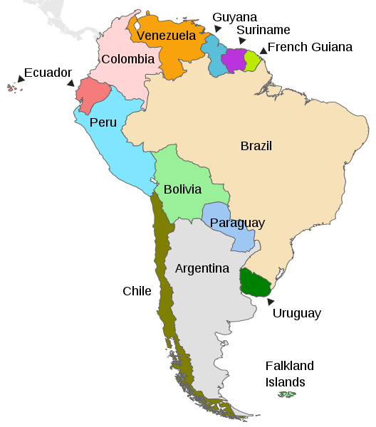
Map depicting the countries on the continent of South America.
Natural Geography of Chile
Major Landforms
The major landforms of Chile are manifested as three parallel north-south features:
- The Chilean Andes to the east
- The intermediate depression, or longitudinal valley, in the center
- The Chilean Coastal Range to the west
Most of Chile's rivers originate in the Andes and flow westward to the Pacific Ocean, draining the intermediate depression and the coastal ranges.
Natural Regions (CORFO)
In 1950, the Corporación de Fomento de la Producción (CORFO), Chile's economic development agency, divided continental Chile into five natural regions based on shared geographic and climatic characteristics. These five regions extend from north to south, with an additional insular region encompassing Chile's islands. Each region is distinguished by its unique combination of vegetation, fauna, climate, and topography, reflecting the country's remarkable ecological diversity.
Norte Grande (Far North)
Most of the Norte Grande region is covered by the Atacama Desert, which has an arid climate. The Coastal Range in the east features peaks over 2,000 m (6,500 ft) and cliffs along the Pacific coast. Large salt flats and mineral deposits exist in the intermediate depression, while the Andes in the east feature Chile's highest mountains. The region also hosts the Altiplano and Puna high plateaus.
Norte Chico (Near North)
The Norte Chico region is characterized by the transition from the Atacama Desert in the north to Mediterranean Matorral vegetation in the south. The climate is semi-arid. Here, the Coastal Range and the Andes merge. Agriculture is limited; however, important gold, copper, and iron deposits are located here.
Zona Central (Central Chile)
The Zona Central region features a Mediterranean climate and Matorral vegetation. The Andes here are massive and high. The Coastal Range and the Andes lose height as they separate to the south. As a result, the summer runoff of large rivers is heavily dependent on glaciers and snowmelt. The Intermediate Depression of central Chile extends from Santiago to the south. It is a fertile region and is considered the agricultural heartland of Chile.
Zona Sur (Southern Zone)
The Zona Sur region features a rainy, temperate climate and Valdivian temperate rainforest vegetation. The Coastal Range and the Andes are low, with an intermediate depression near sea level. The rivers that descend from the Andes rush over volcanic rocks, forming numerous white-water sections and waterfalls. This region features many glacial lakes and intensive volcanic and geothermal activity.
Zona Austral (Austral Zone)
The Zona Austral region covers all of Chilean Patagonia and the Chiloé Archipelago. It features a subpolar oceanic climate, and the vegetation includes Magellanic forest and Magellanic moorland in the west, with Patagonian grasslands in the east. The landscape is glacial, and the Coastal Range consists of islands. Fjords penetrate the Andes, where there are also two ice sheets, the Northern Patagonian Ice Field and the Southern Patagonian Ice Field, along with several glacial lakes.
Insular Chile (Chilean Islands)
Chile also includes several archipelagos off its coast. The most significant are the Juan Fernández Islands, located in the Pacific Ocean, and the remote Easter Island (Rapa Nui), famous for its Moai statues. These islands have distinct ecosystems and cultural traditions.
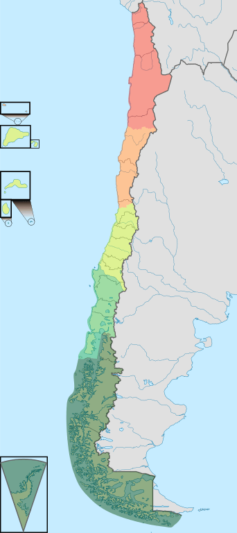
Map depicting the geographic regions of Chile.
Mountain Ranges
Chile is known for its diverse mountainous landscapes, and the Andes Mountains are a prominent feature of its geography. The mountain ranges of Chile offer a wide range of ecosystems, geological formations, and cultural significance. They contribute to the country's stunning landscapes, unique ecology, and cultural heritage.
See more: Mountain Ranges of Chile
Islands and Archipelagos
Due to its extended coastline, Chile has sovereignty over thousands of islands, most of which are in the country's south. Some of the largest islands and archipelagos include:
Easter Island: in the southeastern Pacific Ocean, at the southeasternmost point of the Polynesian Triangle, approximately 3,500 km (2,200 mi) west of the Chilean mainland
Juan Fernández Archipelago: a group of islands situated 670 km (416 mi) off the Pacific coast of Chile in the Valparaíso Region
Tierra del Fuego Archipelago: lies off the southernmost tip of the South American mainland, across the Strait of Magellan in the Magallanes Region.
Chiloé Archipelago: a group of islands lying off the coast of Chile in the Los Lagos Region
Diego Ramírez Islands: a small group of subantarctic islands located about 105 km (65 mi) west-southwest of Cape Horn in the southernmost extreme of Chile
Magdalena Island: located between the Moraleda Channel and the Puyuhuapi Channel in the Aysén Region
See more: Islands and Archipelagos of Chile
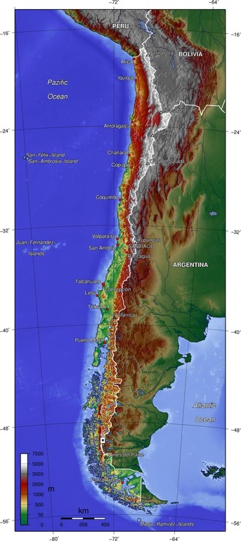
Topographical map of Chile.
Bodies of Water
Chile has diverse water bodies, ranging from expansive rivers and lakes to stunning gulfs, bays, and fjords. The country's extensive coastline stretches along the Pacific Ocean, offering dramatic cliffs, beautiful beaches, and vibrant marine life.
The major rivers in Chile, such as the Loa, Biobío, and Maipo, flow through various regions, providing water resources and supporting ecosystems. Chile is also home to notable lakes like General Carrera, Llanquihue, and Panguipulli, which offer scenic beauty and recreational opportunities.
Chile boasts remarkable gulfs and bays along its coastline, including the Gulf of Penas and the Bay of Concepción. Chile's fjords, such as the Aysén Fjord and the Seno de Reloncaví, also showcase mesmerizing landscapes shaped by glaciers and the sea. Overall, Chile's water bodies contribute to the country's natural splendor and provide many resources and recreational possibilities for locals and visitors alike.
See more: Water Bodies of Chile
Administrative Divisions
Chile is divided into 16 administrative regions. These regions are subdivided into provinces, each administered by a governor appointed by the President of Chile. Provinces are further divided into communes, which are governed by municipal councils.
See more: Cultural Landscape of Chile
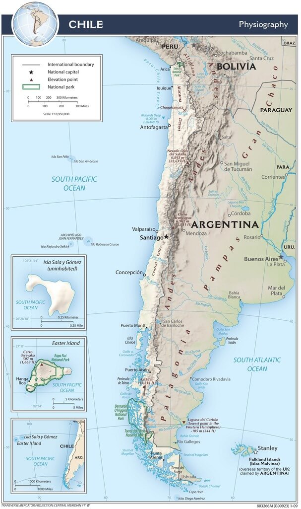
Chile physiographic map.
Biomes
Biomes are natural regions distinguished by geography, climate, and associated flora and fauna. The regions are classified according to their predominant vegetation.
Atacama Desert
The Atacama Desert ecoregion is located in northern Chile between Argentina to the west and the Pacific Ocean to the east. Running east from the Pacific Ocean to the Andes Mountains, an extremely arid, almost barren landscape predominates because, in many areas, rainfall has never been recorded.
Altiplano—Puna
The Altiplano, often called the Altiplano—Puna plateau, is a high-altitude grassland region covering much of it. It is the most extensive area of high plateau outside Tibet.
Central Andean Dry Puna
The Central Andean dry puna ecoregion is an arid, high-elevation montane grassland and herbaceous community of the high southern Andes, extending through western Bolivia, northern Chile, and Argentina. The Central Andean dry puna is a part of the Puna grassland, occupying the southwestern portion of the Altiplano, and is located east of the Atacama Desert.
Valdivian Temperate Forests (Selva Valdiviana)
The Valdivian temperate forests ecoregion is located in the southern cone of South America on Chile's west coast and extends slightly into Argentina. It covers a narrow continental strip between the western slope of the Andes and the Pacific Ocean. The Valdivian temperate forests (Selva Valdiviana) are temperate broadleaf and mixed forests.
Patagonian Forest
The Andean Patagonian Forest spreads over steep elevations along a thin strip on both sides of the Andes Mountains in southern South America. These temperate forests in southern Chile and Argentina are the southernmost forests on Earth.
Southern Andean Steppe
The Southern Andean steppe is a montane grassland and shrubland ecoregion occurring along the border of Chile and Argentina in the high elevations of the southern Andes mountain range. This ecoregion has a cold desert climate.
Ecological Regions
The following is a list of terrestrial ecoregions in Chile, as defined by the World Wide Fund for Nature (WWF). Chile is in the neotropical realm. Ecoregions are classified by biome type—the major global plant communities determined by rainfall and climate.
Tropical and subtropical moist broadleaf forests
Rapa Nui and Sala-y-Gomez subtropical broadleaf forests
Temperate broadleaf and mixed forests
Juan Fernández Islands temperate forests
San Felix-San Ambrosio Islands temperate forests
Temperate grasslands, savannas, and shrublands
Montane grasslands and shrublands
Mediterranean forests, woodlands, and scrub
Deserts and xeric shrublands
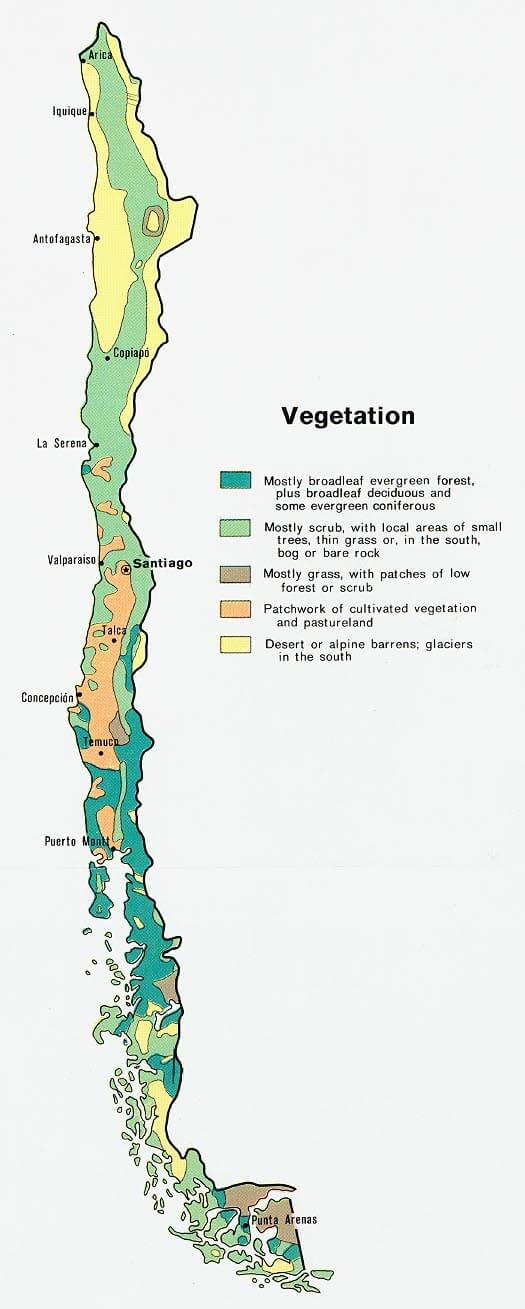
Vegetation map of Chile.