Panama: Natural Landscape
Panama, the southernmost Central American country, links two continents. Bordered by Costa Rica, Colombia, the Caribbean Sea, and the Pacific Ocean, it connects North and South America via the Isthmus of Panama. The Panama Canal is a vital maritime trade route.

, https://www.flickr.com/photos/youngshanahan/33974868861")


 - by Alex Proimos from Sydney, Australia, CC BY 2.0, via Wikimedia Commons")


, https://www.flickr.com/photos/49827629@N08/7722304778")
The Natural Landscape of Panama
Panama, the southernmost nation in Central America, serves as a critical bridge between two continents. Bordered by Costa Rica to the northwest, Colombia to the southeast, the Caribbean Sea to the north, and the Pacific Ocean to the south, Panama is situated on the iconic S-shaped Isthmus of Panama. This slender landmass links the North American Continent and the South American Continent, earning the country global recognition as the home of the Panama Canal, a pivotal artery for international maritime trade.
Panama's geography is a captivating tapestry of coastlines, lowlands, and mountains. Its approximately 1,225 kilometers (760 miles) of Pacific coastline and 760 kilometers (470 miles) of Caribbean coastline are adorned with sandy beaches, mangroves, and coral reefs. These coastal regions gradually transition inland to rolling lowlands, verdant forests, and rugged mountains, showcasing a natural diversity that few countries can rival. The country's strategic location also hosts the Pan-American Highway, a vast network of roads connecting Alaska to Argentina. However, in Panama, the highway is famously interrupted by the Darien Gap, an expanse of dense jungle and swampland that remains one of the world's least explored and most challenging terrains.
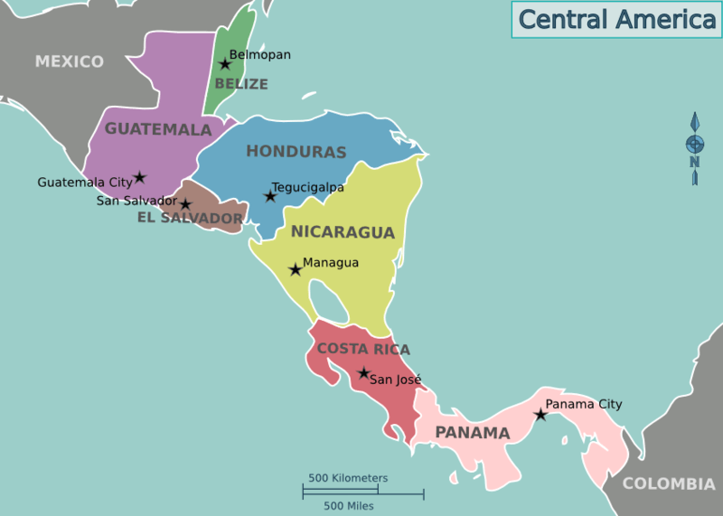
Location map of the countries of Central America.
Biodiversity
Panama's unique position at the crossroads of two continents fosters a remarkable confluence of species from North and South America, making it one of the most biodiverse nations in the world. Its varied habitats, ranging from tropical rainforests and cloud forests to coastal mangroves and coral reefs, support an extraordinary range of life forms. According to the Global Biodiversity Index, Panama ranks as the 25th most biodiverse nation globally and is home to an astounding array of species.
Panama's bird population includes 885 species, such as the resplendent quetzal and the harpy eagle, the national bird. Amphibians are represented by 228 species, including the critically endangered Panamanian golden frog. In its waters, there are 1,428 species of fish thriving in both marine and freshwater environments. The country's mammalian population includes 252 species, with iconic creatures like jaguars, ocelots, and capybaras. Reptiles number 279 species, including caimans, crocodiles, and iguanas. Panama's plant diversity is remarkable, boasting over 10,000 vascular plant species, many of which are endemic.
The isthmus also serves as a crucial biological corridor, enabling migratory species to traverse between North and South America. This unique role enhances Panama's ecological significance and underscores its importance in global biodiversity conservation.
Conservation
Panama's commitment to preserving its natural heritage is evident in its robust conservation efforts. The country has established an extensive network of protected areas, including national parks, wildlife refuges, and nature reserves. Coiba National Park, a UNESCO World Heritage Site, is renowned for its marine and terrestrial ecosystems. Darien National Park, a vast rainforest reserve, is critical for regional biodiversity and home to indigenous communities. Barú Volcano National Park offers a unique montane ecosystem centered around the dormant Volcán Barú.
Despite these initiatives, Panama faces significant environmental challenges. Deforestation, habitat fragmentation, urban expansion, and illegal wildlife trade threaten its ecosystems. Climate change exacerbates these issues, bringing rising sea levels and extreme weather events. However, Panama remains steadfast in its dedication to environmental stewardship. By promoting ecotourism, sustainable agriculture, and renewable energy, the country strives to balance economic development with conservation.
Climate
Panama's tropical climate is characterized by consistently warm temperatures and high humidity throughout the year. While temperatures remain relatively stable, regional variations and seasonal shifts add complexity to the weather. The year is divided into two distinct seasons. The wet season, which lasts from May to December, is marked by heavy rainfall, with annual precipitation often exceeding 2,000 mm (79 inches). The Caribbean coastal areas, particularly in Bocas del Toro, receive the most rainfall.
The dry season, spanning from January to April, features minimal rainfall, lower humidity, and clearer skies, making it the preferred time for tourism. The Caribbean coastal regions are generally wetter and more humid than the Pacific side, which experiences a drier climate. The central highlands, including areas like Boquete, offer cooler and more temperate conditions, providing a refreshing contrast to the lowlands. Although hurricanes are rare in Panama, the country occasionally faces tropical storms and extreme weather events, leading to flooding and landslides. These natural phenomena can cause significant disruptions, particularly in vulnerable rural areas.
Volcanism
While less prominent than its northern neighbors, Panama's volcanic history reveals a fascinating geological backdrop. Situated near the tectonic boundary between the Caribbean Plate and Nazca Plate, Panama has experienced volcanic activity, though most of it occurred millions of years ago. Today, the country is home to dormant volcanic features such as Volcán Barú, Panama's highest peak at 3,475 meters (11,400 feet). From its summit, visitors can enjoy breathtaking views of both the Pacific and Caribbean coasts.
Another significant feature is El Valle de Antón, a caldera surrounded by lush forests and fertile soils, known for its unique microclimate and biodiversity. While Panama lacks active volcanoes, its geothermal potential offers opportunities for renewable energy development. Though large-scale geothermal projects have yet to materialize, the country's volcanic resources remain a promising avenue for sustainable energy.
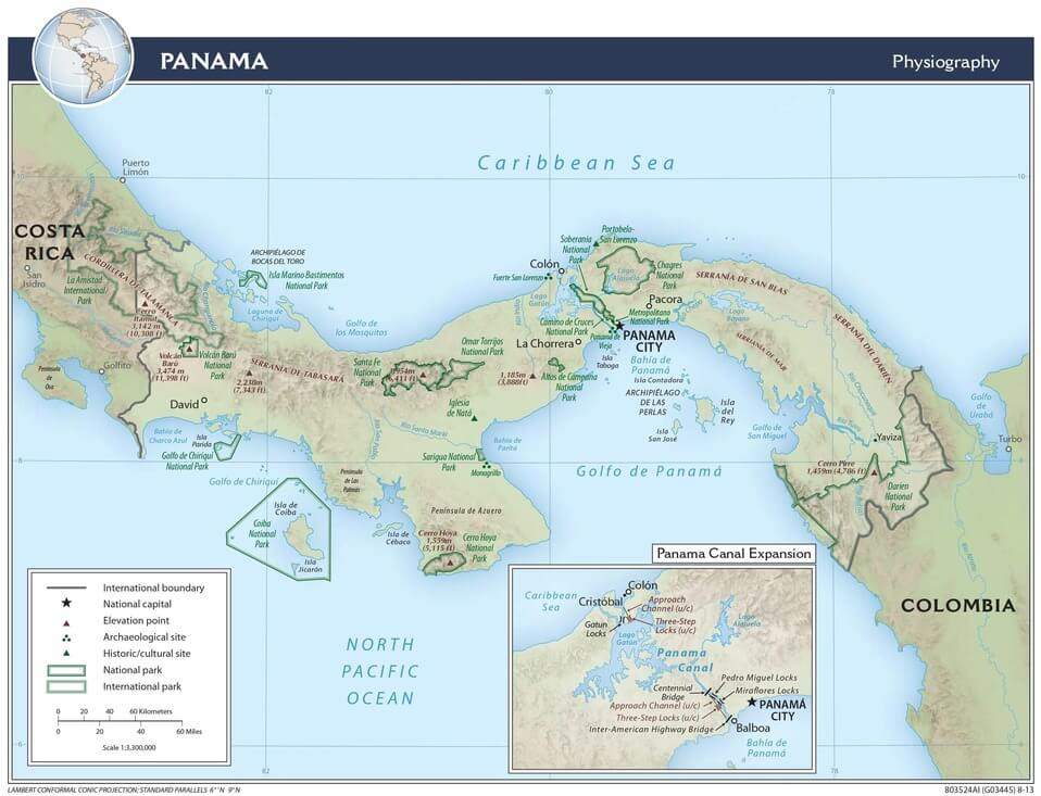
Panama physiographic map.
Physical Geography
Panama's landscape can be categorized into three primary physical regions: mountains, coastal lowlands, and archipelagos. Each region contributes to the country's geographic and ecological diversity.
Two main ranges dominate the mountainous regions. The Cordillera Central, or Tabasará Mountains, spans the western part of the country and includes Volcán Barú. The Cordillera de San Blas extends through the eastern region. These ranges form the Continental Divide, influencing the flow of rivers toward the Pacific or Caribbean. The mountains also provide critical habitats for a variety of species and serve as a water source for lowland areas.
The coastal lowlands cover over 85% of Panama's land area, exhibiting significant variations between the Pacific and Caribbean coasts. The Pacific lowlands are characterized by a broader continental shelf, mangroves, and fertile agricultural lands. Features such as the Gulf of Panama and the Azuero Peninsula define this region. In contrast, the Caribbean lowlands are narrower and less populated, featuring dense rainforests and wetlands, such as the Chiriquí Lagoon and the Darien Gap. The Darien Gap, a nearly impenetrable jungle bordering Colombia, remains one of the world's most biodiverse and untouched regions.
Numerous archipelagos, scattered along Panama's coastlines, enhance the country's maritime charm. Among these is the Bocas del Toro Archipelago, renowned for its vibrant coral reefs and ecotourism off the Caribbean coast. The Pearl Islands, located in the Gulf of Panama, are famous for their pristine beaches and marine biodiversity. The San Blas Islands, home to the Indigenous Guna Yala people, feature unique ecosystems. These archipelagos offer scenic beauty and vital habitats for marine and coastal species.
Conclusion
Panama's natural landscape is a remarkable mosaic of ecological diversity and geographic variety. From its towering mountains and fertile lowlands to its lush rainforests and pristine coastlines, the country's environment is a testament to nature's resilience and beauty. As a biodiversity hotspot and a global conservation leader, Panama's efforts to protect its natural heritage resonate far beyond its borders. By addressing the challenges of climate change, habitat loss, and sustainable development, Panama continues to pave the way for a harmonious relationship between nature and progress. Its unique geographic position and environmental richness make it a treasure for Central America and the entire world.
See more: Islands and Archipelagos of Panama
See more: Water Bodies of Panama
See more: Cultural Landscape of Panama
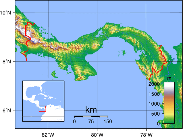
Topographic map of Panama
Natural Regions
Panama is covered in tropical forests and wetlands and possesses Atlantic and Pacific coastal marine areas.
Ecological Regions
The following is a list of terrestrial ecoregions in Panama, as defined by the World Wide Fund for Nature (WWF). Panama is in the neotropical realm. Ecoregions are classified by biome type, which are the major global plant communities determined by rainfall and climate.
Tropical and subtropical moist broadleaf forests
Eastern Panamanian montane forests
Isthmian-Atlantic moist forests
Isthmian-Pacific moist forests
Tropical and subtropical dry broadleaf forests
Panamanian dry forests
Montane grasslands and shrublands
Mangroves
Bocas del Toro-San Bastimentos Island-San Blas mangroves
Gulf of Panama mangroves
Moist Pacific Coast mangroves
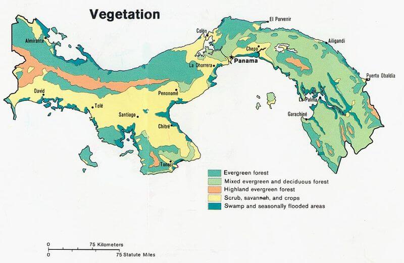
Vegetation map of Panama.