Bolivia: Natural Landscape
Bolivia, a landlocked nation in South America, offers one of the continent's most diverse and complex landscapes. Surrounded by five countries, Bolivia's varied geography is shaped by towering mountains, expansive lowlands, and diverse climatic zones that create a vibrant natural mosaic.


 https://www.flickr.com/photos/eliasroviello/46228761915")


 https://www.flickr.com/photos/lonqueta/7352204604")


The Natural Landscape of Bolivia: A Journey Through Diverse Terrains and Ecosystems
Bolivia, a landlocked nation in the heart of South America, spans approximately 1,100,000 square kilometers (425,000 square miles) and offers one of the continent's most diverse and spectacular landscapes. Bordered by five nations—Brazil to the north and east, Paraguay to the southeast, Argentina to the south, Chile to the southwest, and Peru to the northwest—Bolivia's varied geography encompasses towering mountains, expansive lowlands, and diverse climatic zones, creating an extraordinary natural mosaic.
Topography and Geography
The majestic Andes Mountains dominate Bolivia's western landscape, creating a dramatic north-south spine that fundamentally shapes the country's geography and culture. This rugged mountain range gives rise to Bolivia's Altiplano. On this high-altitude plateau, most major urban centers, including La Paz (the world's highest capital city), Sucre, and Potosí, are situated. The Altiplano, with elevations ranging from 3,600 to 4,000 meters (11,800 to 13,100 feet), serves as both a cultural heartland and economic powerhouse, supporting mining operations, agriculture, and vibrant indigenous communities.
Bolivia's geography undergoes a dramatic transformation as it transitions eastward from mountainous highlands to lowland plains. The eastern lowlands, commonly referred to as the Llanos, are rich in natural resources and encompass substantial portions of the Amazon Rainforest. This region, characterized by meandering tropical rivers, dense forests, and expansive savannas, has experienced rapid population growth and significant economic development over the past few decades. Cities like Santa Cruz serve as gateways to these fertile lands, contributing to a demographic and economic shift that has begun to balance the nation's historically highland-centered development.
Biodiversity: A Global Treasure
Ranking as the 18th most biodiverse country globally according to the Global Biodiversity Index, Bolivia's ecosystems support an extraordinary array of species. The country's ecological wealth comprises over 1,435 bird species, 259 amphibian species, 407 fish species, 382 mammal species, 315 reptile species, and 14,729 vascular plant species, establishing Bolivia as both a biodiversity hotspot and one of the world's seventeen megadiverse nations.
Bolivia's ecosystems span tropical rainforests, cloud forests, savannas, and Andean grasslands, each supporting unique assemblages of life. The Amazon Basin in northern Bolivia serves as a cradle for countless plant and animal species, many of which are still being discovered by scientists. The Yungas cloud forests, draped across the eastern Andean slopes, provide critical habitats for rare and endemic species, including the spectacled bear, Andean cock-of-the-rock, and numerous orchid species. In the high-altitude grasslands and arid deserts of the Altiplano, species have evolved remarkable adaptations to extreme climates, including the graceful Andean flamingo, the hardy vicuña, and the resilient quinoa plant.
Conservation Efforts and Environmental Challenges
Bolivia faces significant conservation challenges as it strives to protect its unique natural heritage while meeting the economic needs of its population. The country's conservation strategy encompasses biodiversity preservation, cultural heritage protection, and landscape conservation across the Amazon Rainforest, Andean highlands, vast wetlands, and high-altitude deserts. Bolivia's conservation efforts focus on preserving unique habitats, ensuring sustainable development, and fostering partnerships among indigenous communities, government bodies, and international organizations.
Critical conservation challenges include deforestation, illegal wildlife trafficking, habitat fragmentation, land-use conflicts, and economic pressures from development. Agricultural expansion, cattle ranching, and fires have a significant impact on forests, particularly in the Amazon and Chiquitano Dry Forests. In recent years, Bolivia has implemented more robust legal frameworks and promoted sustainable land-use practices. National parks and reserves, such as Madidi National Park in the Amazon Basin and Carrasco National Park in the Yungas, play crucial roles in preserving biodiversity while supporting ecotourism and sustainable development initiatives that benefit local communities.
Climate Zones: A Study in Contrasts
Bolivia's climate varies dramatically across its three main geographical regions, creating distinct ecological zones:
The Andean Highlands: The Andean region experiences a cold and arid climate, with temperatures ranging from 5 to 15°C (41 to 59°F). Annual rainfall is minimal, averaging less than 500 millimeters (20 inches), concentrated in the rainy season from December to March. The harsh, high-altitude environment of the Altiplano contrasts sharply with the lush valleys found along the eastern slopes, which enjoy milder temperatures and increased precipitation.
The Sub-Andean Valleys: These semi-tropical valleys experience pleasant average temperatures of 15 to 25°C (59 to 77°F) and receive between 500 and 1,000 millimeters (20 to 40 inches) of rain annually. The valleys maintain a mild, temperate climate that makes them highly productive agricultural regions. The Yungas region, located in the northeastern valleys, boasts a humid climate and fertile soils, which support dense cloud forests and a remarkable agricultural diversity, including coffee, coca, and a variety of tropical fruits.
The Tropical Lowlands: The eastern lowlands experience a hot and humid tropical climate, with average temperatures from 25 to 30°C (77 to 86°F). Annual rainfall exceeds 2,000 millimeters (80 inches), with a pronounced rainy season from September to May. These lush tropical forests, which form part of the Amazon Basin, support extensive wetlands, meandering rivers, and complex rainforest ecosystems.
Volcanism and Geological Heritage
Although Bolivia lacks active volcanoes, its location on the Pacific Ring of Fire has resulted in a rich volcanic legacy. Several dormant and extinct volcanoes dot the western Andean ranges, where Bolivia shares volcanic terrain with neighboring Chile and Peru. The dormant Parinacota and Pomerape volcanoes, along with the striking Licancabur Volcano near the Uyuni Salt Flats, exemplify Bolivia's volcanic heritage. These geological formations, combined with the vast Andean ranges, create dramatic landscapes that attract geologists, adventurers, and tourists from around the world.
Salt Flats and Unique Landforms
Among Bolivia's most iconic and otherworldly landscapes is the Salar de Uyuni, the world's largest salt flat, spanning over 10,000 square kilometers (3,860 square miles) across the Altiplano. These salt flats formed from prehistoric lakes that evaporated over millions of years, leaving behind a thick, crystalline salt crust. During the rainy season, a thin layer of water transforms the flat into a vast mirror, creating surreal and reflective landscapes that have become synonymous with Bolivia's natural beauty. Beyond their visual splendor, the Uyuni Salt Flats serve as both a major tourist attraction and a source of valuable minerals, including lithium, positioning Bolivia as a potentially significant player in the global clean energy transition.
Summary
Bolivia's natural landscape stands as a testament to the country's extraordinary ecological and geological richness. From the icy peaks of the Andes to the lush Amazonian lowlands and the awe-inspiring Uyuni Salt Flats, Bolivia encompasses a remarkable diversity of environments within its borders. This amazing natural heritage, while facing modern conservation challenges, continues to support millions of species and indigenous communities while offering visitors some of the world's most spectacular and unspoiled landscapes. Bolivia's commitment to striking a balance between conservation and development will be crucial in preserving this natural treasure for future generations while supporting the livelihoods of its people.
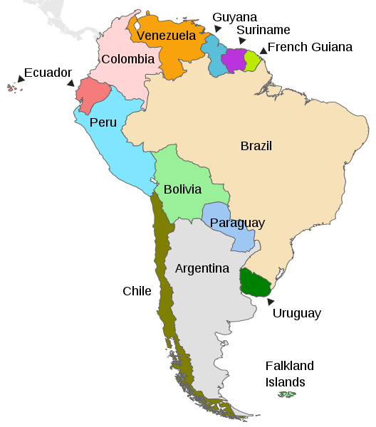
Map depicting the countries on the continent of South America
Natural Geography of Bolivia
Bolivia's dramatic landscape is sculpted by the mighty Andes Mountains, which sweep across the western portion of the country in a broad arc, creating three distinct geographic zones that showcase remarkable environmental diversity. Each zone possesses unique topographical features, climatic conditions, and ecological characteristics that have shaped Bolivia's natural heritage and human settlement patterns.
Geographic Zones Overview
The Andes Mountains serve as the organizing principle for Bolivia's geography, dividing the country into three primary zones:
- Western Zone: The Bolivian Andes and the Altiplano plateau
- Central Zone: The Semi-tropical Yungas, Highland Valleys, and Gran Chaco
- Eastern Zone: The Tropical Lowlands
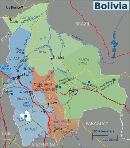
Map showing Bolivia's three geographic zones and their departments.
Western Zone: Andes Mountains and Altiplano
The Bolivian Andes consist of two parallel mountain ranges that create the country's most dramatic topography. The Cordillera Occidental (Western Range) runs along Bolivia's border with Chile, forming a chain of dormant volcanoes with numerous isolated peaks. This range extends southward into Chile, creating Bolivia's western frontier. In contrast, the Cordillera Oriental (Eastern Range) forms a high, broad mountain system stretching from Peru to Argentina. Geographers often subdivide this eastern range into the northern "Cordillera Real" and the southern "Cordillera Central," both of which trend generally south and southeast, forming the eastern boundary of the Altiplano before continuing into northern Argentina.
Nestled between these two mountain ranges lies the remarkable Altiplano plateau, stretching approximately 800-900 kilometers (500-560 miles) in length and 130-200 kilometers (80-125 miles) in width. This high-altitude plain encompasses a diverse landscape of valleys, rolling hills, salt flats, volcanoes, rivers, and lakes. The plateau extends southward from the vicinity of Lake Titicaca into northern Chile and Argentina, creating a unique high-altitude ecosystem.
The Altiplano's most celebrated feature is the world-famous Salar de Uyuni, alongside other significant salt flats and colorful lagoons. Lake Titicaca, situated in the northern Altiplano, stands as the region's most prominent body of water and the world's highest navigable lake. Scattered volcanic peaks dot the landscape, creating a dramatic skyline across the plains and mesas.
The Altiplano's climate is characterized by cold temperatures and persistent winds, creating challenging conditions for vegetation. The landscape remains largely treeless, supporting sparse vegetation adapted to harsh conditions, including tough clumps of ichu grass (Jarava ichu), thola bushes (Baccharis dracunculifolia), and occasional stands of quinoa plants and queñua bushes that have sustained indigenous communities for millennia.
Central Zone: Yungas, Highland Valleys, and Gran Chaco
The Yungas region cascades down the northeastern slopes of the Cordillera Real, forming a rugged, largely undeveloped landscape of steep, jungle-covered mountains. These mountains gradually descend eastward until they merge with the tropical lowlands, creating a dramatic transition zone. The upper elevations of the Yungas support mystical cloud forests, while the climate remains hot and humid with substantial precipitation. Glacial rivers tumble through the region from the snow-capped Andean peaks, eventually joining the upper Amazon Basin. This biodiverse region, rich in flora and fauna, is crisscrossed by ancient Inca trails that once connected highland and lowland civilizations.
The Highland Valleys region, located east and southeast of the Altiplano, enjoys Bolivia's most temperate and hospitable climate. This area encompasses the central Cordillera's rolling hills, fertile valleys, and sheltered basins. The rich soils and Mediterranean-like climate have made this Bolivia's second-most populous region, supporting major cities including Cochabamba, Sucre, Tarija, and Potosí. The region's favorable conditions have historically made it an important agricultural and cultural center.
The Gran Chaco occupies the southeastern corner of the Santa Cruz department, extending into Argentina and Paraguay. This challenging landscape presents harsh, nearly impenetrable terrain characterized by flat expanses of thick brush, cacti, grassy plains, and scattered forested areas. Despite its hot, dry climate, the Gran Chaco supports a remarkable biodiversity, housing diverse flora and fauna that are well-adapted to its demanding conditions.
Eastern Zone: Tropical Lowlands
The tropical lowlands encompass all territory north and east of the Andes, comprising over two-thirds of Bolivia's national territory despite supporting a relatively sparse population. This vast region encompasses most of Bolivia's major river systems and exhibits significant environmental variation due to topography and climate, resulting in three distinct sub-regions.
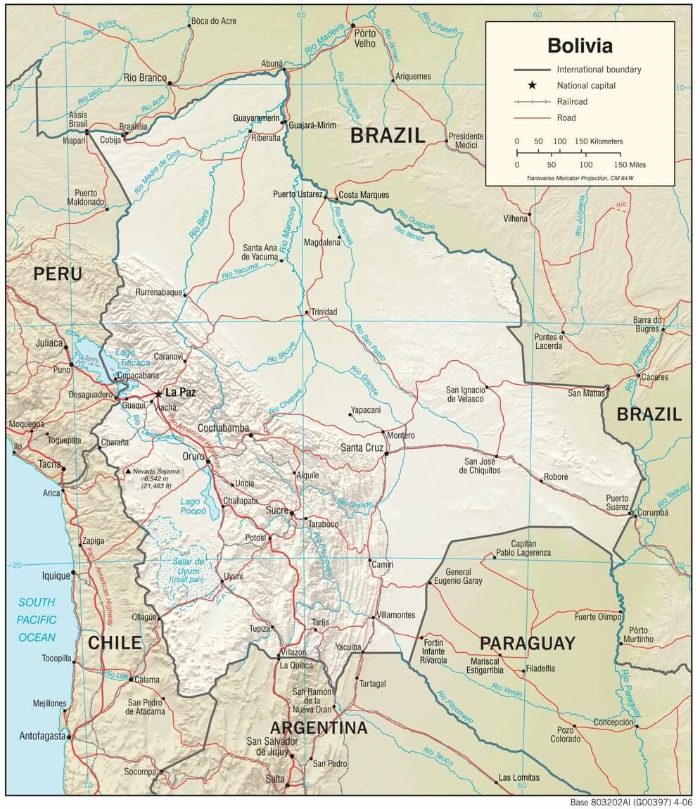
The northern lowlands encompass the Beni and Pando departments, as well as the northern portion of the Cochabamba Department. This flat, tropical region supports extensive rainforests, though poor drainage conditions create unique challenges. Much of the topsoil overlies clay hardpan, resulting in inadequate drainage that periodically transforms vast areas into seasonal swamplands during heavy rains. Wide, slow-moving rivers drain this region, with the major waterways—the Mamoré, Beni, and Madre de Dios rivers—flowing northward into Brazil's Madeira River before joining the Amazon River system.
The central lowlands, encompassing the northern half of the Santa Cruz Department, feature gently rolling hills and a drier climate than the northern region. This area presents a mosaic landscape where forests alternate with natural savanna, and extensive land clearing has opened areas for agricultural cultivation. Santa Cruz, the largest city in the lowlands and Bolivia's economic powerhouse, anchors this region. The area also contains most of Bolivia's petroleum and natural gas reserves, making it economically vital to the nation.
The southeastern lowlands represent a continuation of the Paraguayan Chaco, characterized by extreme seasonal variations in precipitation. This region remains virtually rainless for nine months of the year, then transforms into extensive swampland during the three months of heavy rains. These extreme conditions support only hardy thorny scrub vegetation and limited cattle grazing, creating one of Bolivia's most challenging but ecologically interesting environments.
Conclusion
Bolivia's natural geography represents a remarkable study in environmental diversity, from the icy peaks of the Andes to the steamy rainforests of the Amazon Basin. The country's three geographic zones create distinct ecosystems that have shaped human settlement patterns, economic development, and cultural traditions throughout Bolivia's history. This geographic complexity continues to influence Bolivia's development challenges and opportunities, making the country one of South America's most environmentally diverse nations.
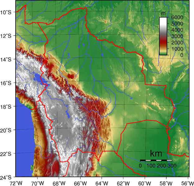
Topographical map of Bolivia: plains of the Amazon Basin in green, Sub-Andean Zone in red, Eastern and Western Cordilleras in white, Altiplano in gray.
Mountain Ranges
Bolivia boasts a diverse and extensive array of mountain ranges, predominantly shaped by the Andes Mountains, which run through its western region. These ranges offer breathtaking landscapes, rich biodiversity, and cultural significance.
See more: Mountain Ranges of Bolivia
Islands and Archipelagos
Bolivia is a landlocked country in the heart of South America with no coastline along the sea or ocean. Therefore, Bolivia does not have any islands in the traditional sense. However, Bolivia has several islands in Lake Titicaca, located on the border between Bolivia and Peru. Lake Titicaca is the largest lake in South America and the highest navigable lake in the world. Here are some of the notable islands in Lake Titicaca that belong to Bolivia:
Isla del Sol (Island of the Sun): Perhaps the most famous island in Lake Titicaca, Isla del Sol is considered sacred in Inca mythology. It features historical ruins and terraces, including the "Pilcocaina" and "Yumani" staircases, which are remnants of ancient Inca and pre-Inca civilizations.
Isla de la Luna (Island of the Moon): Located near Isla del Sol, this island is also historically and culturally significant. The Incas dedicated ruins and temples to the Moon goddess.
Isla Pariti: This island is known for its relatively small size and is located near the eastern shore of Lake Titicaca.
Isla Kalahuta: Located near the southern part of Lake Titicaca, this island is known for its traditional reed boat construction and way of life.
Isla Suriqui: Located near the southeastern shore of Lake Titicaca, this island is known for its picturesque landscapes and tranquility.
Bodies of Water
Bolivia is a landlocked country in South America, which means it lacks direct access to the ocean. However, it is home to several notable water bodies. While Bolivia's water bodies may not have coastal landscapes, they still play a vital role in the country's geography, ecology, and cultural heritage.
Bolivia is home to the iconic Lake Titicaca, the highest navigable lake in the world, which is shared with Peru. Lake Poopó, situated in the Altiplano region, is another significant lake, although its size and water levels have fluctuated significantly in recent years. The country also has various rivers, including the Beni, Mamoré, and Paraguay rivers, which provide essential transportation routes and support diverse ecosystems.
See more: Water Bodies of Bolivia
Administrative Divisions
Bolivia's primary political subdivisions are the nine departments, each of which is represented by four senators in the Senate.
See more: Cultural Landscape of Bolivia
A physiographic map of Bolivia.
Ecological Regions
The following is a list of terrestrial ecoregions in Bolivia, as defined by the World Wildlife Fund (WWF). Bolivia is in the neotropical realm. Ecoregions are classified by biome type, which refers to the major global plant communities determined by rainfall and climate.
Tropical and subtropical moist broadleaf forests
Madeira-Tapajós moist forests
Southwest Amazon moist forests
Tropical and subtropical dry broadleaf forests
Tropical and subtropical grasslands, savannas, and shrublands
Flooded grasslands and savannas
Montane grasslands and shrublands
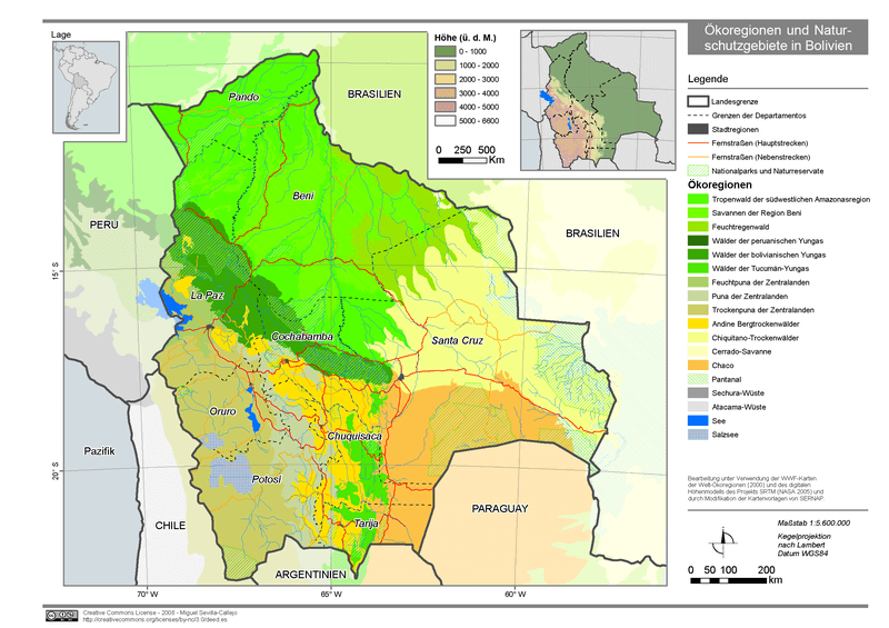
Map of Bolivia's ecoregions.