Guyana: Natural Landscape
In northeastern South America, Guyana is renowned for its unique geography and natural beauty. It has an Atlantic coastline and shares borders with Suriname, Venezuela, and Brazil. As the third smallest nation on the continent, Guyana has diverse ecosystems, ranging from rainforests to savannas.

, https://www.flickr.com/photos/davidstanleytravel/14129136463")
 https://www.flickr.com/photos/sorenriise/395861020/")


 via Wikimedia Commons")


, Guyana-Brazil border - by David Stanley, (CC BY 2.0), https://www.flickr.com/photos/davidstanleytravel/14081736074")

 https://www.flickr.com/photos/comsec/3570687236")
The Natural Landscape of Guyana
Nestled in northeastern South America, Guyana, formerly known as British Guiana, is a nation defined by its unique geography and natural beauty. With a coastline stretching approximately 459 kilometers (285 miles) along the Atlantic Ocean, Guyana shares borders with Suriname to the east, Venezuela to the west, and Brazil to the west and south. Although it is the third-smallest country on the continent, covering 214,970 square kilometers (83,000 square miles), Guyana boasts a remarkable array of ecosystems, from dense rainforests to sprawling savannas. Its strategic location, biodiversity, and natural resources position Guyana as a dynamic participant in the Caribbean and South American regions.
Geographic Context and Regional Affiliation
Guyana is part of The Guianas, which includes Suriname (formerly Dutch Guiana) and French Guiana. These countries share a colonial history and cultural heritage shaped by European, African, and Indigenous influences. Additionally, Guyana is classified within the Caribbean South America subregion, connecting it culturally and economically with other Caribbean and South American nations. As a member of the Caribbean Community (CARICOM) and the Union of South American Nations (UNASUR), Guyana maintains a regional presence emphasizing cooperation and shared interests. Recent discoveries of substantial oil reserves are expected to further enhance Guyana's role in the region, bringing economic growth and new opportunities.
Biodiversity: A Global Treasure Trove
Guyana is a global biodiversity hotspot known for its vast range of ecosystems and species. The country's low population density and extensive tropical climate contribute to this biodiversity, creating natural habitats that have remained relatively undisturbed.
Rainforests and the Guiana Shield
Guyana's rainforests, primarily located in the interior, are part of the ancient Guiana Shield. This geological formation spans portions of South America and is among the oldest formations on Earth. These rainforests house an extraordinary variety of plant and animal life, many of which are endemic to the region. According to the Global Biodiversity Index, Guyana ranks 37th worldwide in biodiversity, highlighting its critical role in global conservation.
Species Richness
Guyana is home to an impressive array of species. The nation hosts approximately 793 bird species, 135 amphibian species, 996 fish species, 236 mammal species, 175 reptile species, and around 6,500 species of vascular plants. This diversity includes iconic animals such as the jaguar, giant river otter, harpy eagle, and scarlet macaw, each emblematic of Guyana's rich natural heritage. The dense rainforests, rivers, and mountainous regions provide habitats that support these species, showcasing the country's ecological wealth and contributing to scientific research and eco-tourism.
Conservation Efforts in Guyana
Guyana has established a network of protected areas and conservation initiatives to safeguard its ecosystems. These efforts reflect the country's commitment to preserving biodiversity and ensuring sustainable development.
Key Protected Areas
Kaieteur National Park: Known for the majestic Kaieteur Falls, one of the world's tallest single-drop waterfalls, Kaieteur National Park protects a pristine section of rainforest home to unique flora and fauna. The park plays a crucial role in conservation and eco-tourism, attracting visitors and researchers worldwide.
Iwokrama Forest Reserve: Situated in the heart of Guyana's rainforest, the Iwokrama Forest Reserve is dedicated to sustainable forest management, research, and wildlife conservation. Managed in collaboration with indigenous communities, Iwokrama promotes sustainable practices while preserving biodiversity, making it a model for conservation.
Kanuku Mountains: Located in southern Guyana, the Kanuku Mountains provide critical habitats for many species. This protected area is essential for conserving endangered species, supporting local biodiversity, and preserving the natural landscape for future generations.
These conservation areas underscore Guyana's commitment to sustainable development and environmental stewardship. Still, the country faces challenges such as deforestation from logging and mining activities, illegal wildlife trade, and climate change. Rising sea levels, shifting rainfall patterns, and temperature fluctuations impact ecosystems and threaten their species. Addressing these issues is crucial to maintaining the ecological integrity of Guyana's natural landscapes.
Climate: A Tropical Diversity
Guyana experiences a tropical climate characterized by high temperatures and humidity year-round, with average temperatures around 27°C (81°F) and humidity levels near 85%. While seasonal temperature changes are minimal, rainfall patterns significantly shape the climate across regions.
Rainfall and Seasons
Guyana's two main seasons, the wet and dry, define its annual climate cycle. The wet season lasts from December to July and is marked by heavy rainfall, with annual precipitation averaging over 3,000 mm (118 inches) in some areas. During the dry season, from August to November, rainfall decreases, though precipitation remains relatively consistent. The country's northern regions receive the highest rainfall, while the southern and interior areas experience comparatively lighter precipitation.
Regional Climate Variations
Guyana's geographical diversity contributes to notable regional climate differences:
- Coastal Areas: Warmer and more humid coastal regions experience minimal temperature fluctuations and relatively stable weather patterns.
- Interior and Mountainous Areas: Due to elevation, the interior regions and the southern mountains have slightly cooler and less humid conditions. The Kanuku and Pakaraima mountain ranges create microclimates that support unique ecosystems distinct from the surrounding lowlands.
These climate variations enable Guyana to support a wide range of ecosystems, from mangrove forests along the coast to cloud forests in the mountains, each contributing to the nation's biodiversity.
Natural Resources and Economic Potential
Guyana's natural resources, including vast rainforests, mineral deposits, and fertile land, are integral to its economy and regional significance. Forests cover over 80% of the country, offering both ecological benefits and economic opportunities through sustainable logging and eco-tourism. Mineral resources, such as bauxite, gold, and diamonds, have traditionally been important to Guyana's economy, with mining operations contributing significantly to the nation's GDP.
The recent discovery of extensive offshore oil reserves has positioned Guyana as an emerging energy producer. With an estimated reserve of over 10 billion barrels of oil, this discovery is expected to transform the economy, drawing investment and fostering development. However, it also poses environmental risks and challenges, underscoring the importance of responsible resource management in balancing economic growth with conservation.
Environmental Challenges and Conservation Strategies
Guyana's commitment to conservation faces several challenges as the country strives to balance development with ecological sustainability. Critical environmental concerns include:
- Deforestation and Habitat Loss: Deforestation from logging and mining disrupts natural habitats, threatening species and diminishing biodiversity. Sustainable forestry practices and stricter regulations are essential to minimizing these impacts.
- Climate Change: Rising sea levels, particularly along the vulnerable coastline, and shifts in rainfall patterns threaten ecosystems and human settlements. Adaptive measures, including mangrove restoration and coastal defenses, are being implemented to mitigate these effects.
- Illegal Wildlife Trade: Guyana's rich biodiversity makes it susceptible to unlawful wildlife trade, which threatens endangered species and disrupts ecosystems. Law enforcement and community engagement are vital in combating this issue.
- Oil Development and Environmental Risks: The offshore oil boom presents opportunities and environmental risks. Guyana faces the challenge of developing policies that ensure sustainable and safe oil extraction to minimize ecological disruption.
Government initiatives and partnerships with international conservation organizations aim to address these challenges. Protected areas, such as Kaieteur National Park and Iwokrama Forest, are crucial in preservation efforts. At the same time, local and indigenous communities participate actively in conservation, ensuring that development respects ecological boundaries.
Conclusion
Guyana's natural landscape is a testament to the country's geographical diversity and ecological richness. From the rainforests of the Guiana Shield to the rolling savannas and mountainous regions, Guyana boasts an array of ecosystems home to an impressive range of species. Its tropical climate, characterized by distinct wet and dry seasons, further supports biodiversity across coastal, interior, and mountainous areas.
While economic opportunities from resources such as minerals, timber, and oil bring growth potential, they also pose challenges that require careful management. Guyana strives to protect its natural heritage while fostering development through conservation initiatives, sustainable practices, and community involvement. As a regional leader in conservation, Guyana's efforts to preserve its natural landscape and biodiversity remain vital to its identity, economy, and role in global ecological conservation.
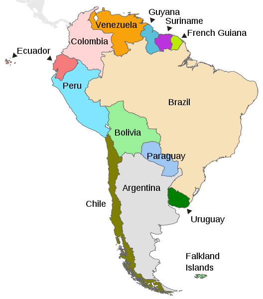
Map depicting the countries on the continent of South America.
Natural Geography of Guyana
Geographic Zones
Three primary regions or zones characterize Guyana's geographical landscape:
- Coastal Plain: A narrow expanse along the Atlantic coast, this fertile marshy plain is densely populated and serves as a vital center for human activity and development.
- White Sand Belt: Extending inland, this region features a hilly terrain with white sand and clay. It houses most of Guyana's valuable mineral deposits and is crucial to its economic and resource infrastructure.
- Interior Highlands: Encompassing the remaining expanses of the country, the interior highlands consist of diverse landscapes, including dense rainforests, grassy flat savannas in the south, and elevated mountainous terrain extending towards the Brazilian border. This region adds to Guyana's geographical richness, showcasing a variety of ecosystems and elevations.
Coastal Plain
The coastal plain of Guyana stretches along the Atlantic Ocean, with an average width of 5-6 kilometers (3-4 miles) and a maximum width of 16 kilometers (10 miles). This narrow expanse, encompassing more than 90% of the country's population, plays a pivotal role in Guyana's socio-economic landscape.
A 450-kilometer (280-mile) seawall spans most of the coastline to safeguard settlements, including the capital city of Georgetown. This seawall is crucial for mitigating the impact of areas below sea level during high tide. Ongoing efforts, dating back to the 18th century, involve the construction of canals and dikes to manage flooding in this low-lying region.
The coastal plain is a product of constant geological activity. It comprises alluvial mud carried to the sea by the Amazon River in the south and transported northward by ocean currents. This mud layer overlays white sands and clays eroded from the interior bedrock by Guyana's rivers.
Unlike typical shorelines, Guyana's coast lacks well-defined beaches. Seaward from the vegetation line, the landscape transforms into mud flats, shallow waters, and sandbars. These shallow waters pose challenges to shipping, often necessitating cargo unloading before vessels can reach the docks in Georgetown and New Amsterdam. The complex interplay of geological forces and human interventions defines the unique character of Guyana's coastal plain.
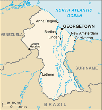
Guyana shaded relief map.
White Sand Belt
The White Sand Belt, positioned inland from the coastal plain, unfolds as a landscape characterized by low sandy hills punctuated with rocky outcroppings. A chain of swamps acts as a natural boundary between these interior hills and the coastal plain. The undulating terrain of this region gradually ascends from an average height of 15 meters (50 feet) in the east, nearest the coast, to 120 meters (400 feet) in the west.
The White Sand Belt, cloaked in a dense hardwood forest, is a critical ecological asset. Despite its sandy composition making it unsuitable for agriculture, the forest is crucial in preventing rapid and severe erosion. Notably, this region houses significant reserves of Guyana's bauxite, gold, and diamond resources.
A small savanna region emerges toward the east, approximately 100 kilometers (60 miles) from the coast, encircled by a low plateau partially overlaid by the White Sand Belt. The plateau, forming the country's central expanse, is marked by igneous rock intrusions, contributing to numerous rapids along Guyana's rivers. This intricate geological interplay defines the White Sand Belt region's unique character and resource-rich nature.
Interior Highlands
The largest among Guyana's geographical regions, the interior highlands unfold a landscape characterized by plateaus, flat-topped mountains, and expansive savannahs extending from the white sand belt to the nation's southern borders. Dominating this region is a vast expanse of grassland, with the Rupununi Savannah in southern Guyana serving as its most significant manifestation, stretching into the territories of Venezuela and Brazil.
The western sector of the interior highlands is marked by the imposing Pacaraima Mountains (or Pakaraima Mountains), notably featuring Mount Roraima, situated at the tripoint border of Brazil, Guyana, and Venezuela. To the south, the Kaieteurian Plateau unfolds, adorned with the majestic Kaieteur Falls, alongside the formidable Kanuku Mountains. Further south, the Acarai Mountains line the border with Brazil.
Among Guyana's loftiest peaks, notable summits include:
- Mount Ayanganna: 2,042 meters (6,699 feet)
- Monte Caburaí: 1,465 meters (4,806 feet)
- Mount Roraima: 2,772 meters (9,094 feet)
This expansive and diverse interior highlands region showcases Guyana's topographical richness, featuring a stunning array of geological formations and elevations.
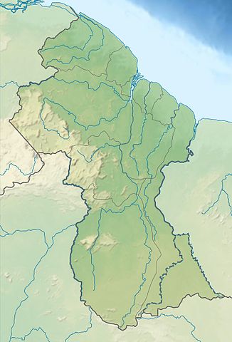
Relief map of Guyana.
Islands
There are many islands in Guyana, most of which are in the Essequibo River, the country's longest. The river has over 365 islands. Some of the notable islands of Guayana include:
Hogg Island: Hogg Island is the largest island in Guyana and is not part of the Essequibo River system. It is located in the Atlantic Ocean, about 30 km (19 mi) off the coast of Guyana. The island is home to about 1,000 people.
Fort Island: Fort Island is located in the Demerara River, about 10 km (6 mi) from Georgetown. It is home to a fort built in the 1700s.
Wakenaam Island: Wakenaam Island is the largest island in the Essequibo River. It is 100 km (62 mi) long and 30 km (19 mi) wide and is home to about 2,000 people.
Leguan Island: Leguan Island is the second-largest island in the Essequibo River. It is 70 km (43 mi) long and 20 km (12 mi) wide and is home to about 1,000 people.
Bartica Island: Bartica Island is located at the mouth of the Essequibo River. It is 5 km (3 mi) long and 2 km (1.2 mi) wide and is home to about 5,000 people.
Trinidad Island: Trinidad Island is located in the Essequibo River, about 50 km (31 mi) downstream from Bartica. The island is home to about 100 people.
Apai Island: Apai Island is located in the Essequibo River, about 100 km (62 mi) downstream from Wakenaam Island. The island is home to about 50 people.
Kaituma Island: Kaituma Island is located in the Essequibo River, about 150 km (93 mi) downstream from Wakenaam Island. The island is home to about 20 people.
Waini Island: Waini Island is located in the Essequibo River, about 200 km (124 mi) downstream from Wakenaam Island. The island is home to about ten people.
Bodies of Water
Guyana is home to a diverse range of bodies of water that play a crucial role in shaping its landscape, ecosystems, and economy. From large rivers and extensive estuaries to coastal lagoons and offshore zones, Guyana's bodies of water provide a wealth of natural resources, support a wide array of wildlife, and offer numerous opportunities for recreation and livelihoods.
See more: Water Bodies of Guyana
Administrative Divisions
Guyana has been divided administratively into ten regions and 27 neighborhood councils.
See more: Cultural Landscape of Guyana
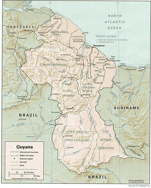
CIA map of Guyana.
Natural Regions
Guyana's diverse landscape can be classified into four distinct natural regions:
Low Coastal Plain: Most of the population resides in this narrow, fertile, marshy plain along the Atlantic coast. It serves as a vital hub for human settlement and economic activities.
Hilly Sand and Clay Region (White Sand Belt): This region houses Guyana's principal mineral deposits further inland. Characterized by undulating terrain, it plays a significant role in the nation's mineral resource infrastructure.
Forested Highland Region: Nestled in the heart of the country, dense rainforests define this region. These lush forests are critical to Guyana's biodiversity and contribute to the nation's ecological richness.
Interior Savanna: Encompassing the grassy flat savanna in the south and the extensive interior highlands, this region is predominantly marked by mountains gradually ascending toward the Brazilian border. The interior savanna showcases a captivating blend of grasslands and elevated terrains, adding to Guyana's geographical diversity.
Ecological Regions
The following is a list of terrestrial ecoregions in Guyana, as defined by the World Wide Fund for Nature (WWF). Guyana is in the neotropical realm. Ecoregions are classified by biome type—the major global plant communities determined by rainfall and climate.
Tropical and subtropical moist broadleaf forests
Guianan Highlands moist forests
Pantepui forests and shrublands
Tropical and subtropical grasslands, savannas and shrublands
Mangroves
Guianan mangroves
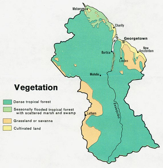
Vegetation map of Guyana.