Suriname: Natural Landscape
Suriname, the smallest sovereign state in South America, is located on the northeastern Atlantic coast. It features diverse ecosystems, including coastal wetlands and mangrove forests. Approximately 90% of the country is covered by dense tropical rainforests, the highest forest cover percentage in the world.
, https://www.flickr.com/photos/-jvl-/33408890481/in/album-72157714724476982/")
 https://www.flickr.com/photos/speakingoffaith/5726984481")

, https://www.flickr.com/photos/-jvl-/31203642896/in/album-72157714724476982/")
, https://www.flickr.com/photos/-jvl-/30394425793/in/album-72157714724476982/")


 https://www.flickr.com/photos/mr-pi/11113358515/")


 https://www.flickr.com/photos/delphinidaesy/6863290621")
The Natural Landscape of Suriname
Suriname, located on South America's northeastern Atlantic coast, borders Guyana to the west, French Guiana to the east, Brazil to the south, and the Atlantic Ocean to the north. The country spans around 386 kilometers (239 miles) of Atlantic coastline, offering a mix of coastal wetlands, river estuaries, and dense mangrove forests. Covering just under 165,000 square kilometers (64,000 square miles), Suriname is the smallest sovereign state on the continent, yet its geographical diversity and ecological significance are remarkable.
Formerly known as "Dutch Guiana," Suriname is part of the geographical and cultural collective called "The Guianas," alongside Guyana and French Guiana. This grouping reflects shared historical ties as former European colonies, with distinct yet overlapping influences in their landscapes, biodiversity, and cultures. Additionally, Suriname's position within the Caribbean South America subregion, alongside Colombia, Venezuela, Guyana, and French Guiana, links it to both South American and Caribbean environmental and cultural dynamics.
The capital, Paramaribo, is the main urban hub and is home to nearly half of the country's population. The majority of Suriname's population resides along the coastal regions, where fertile soils and access to waterways have fostered settlements, agricultural activities, and trade routes. Inland, however, lies a vastly different landscape, with pristine rainforests, rivers, and savannas covering most of Suriname's territory and contributing to its status as one of the most forested countries in the world.
Biodiversity
Suriname is recognized as a global biodiversity hotspot, ranking 42nd on the Global Biodiversity Index. It is home to a breathtaking variety of ecosystems, each supporting a unique range of flora and fauna. Within its borders, Suriname boasts approximately 696 bird species, 114 amphibian species, 1,046 fish species, 207 mammal species, 156 reptile species, and around 5,100 species of vascular plants, many of which are endemic to the region.
Suriname's rich biodiversity is primarily concentrated in its dense tropical rainforests, which cover approximately 15 million hectares (37 million acres), or about 90% of the country's total land area—the highest percentage of forest cover worldwide. This vast forested landscape is crucial to global carbon sequestration efforts. It absorbs carbon dioxide while producing oxygen, helping to regulate the planet's climate. Suriname's forest cover also serves as a refuge for countless species, providing a sanctuary for those threatened by deforestation in neighboring countries.
The intricate ecosystems within these forests encompass diverse habitats, including lowland rainforests, montane forests, and coastal mangroves. Each supports species uniquely adapted to Suriname's environment, including rare mammals like the jaguar, giant anteater, and ocelot, as well as smaller species such as poison dart frogs, howler monkeys, and harpy eagles. River systems, such as the Suriname, Marowijne, and Coppename rivers, further enhance biodiversity, supporting aquatic ecosystems that include fish, amphibians, and reptiles, some of which are found only in Suriname.
Conservation
Conservation initiatives in Suriname are pivotal to preserving its biodiversity and protecting the ecosystems that support it. The government and environmental organizations have worked to establish protected areas, including nature reserves and wildlife sanctuaries, which act as refuges for endemic and endangered species. These protected areas conserve biodiversity and offer opportunities for ecotourism and educational outreach, promoting environmental awareness and sustainable practices.
The Central Suriname Nature Reserve is one of the most significant conservation areas, covering 1.6 million hectares of pristine rainforest. As a UNESCO World Heritage Site, it is renowned for its extensive biodiversity and the unspoiled quality of its ecosystems. Another prominent conservation area, Brownsberg Nature Park, is celebrated for its scenic landscapes and high biodiversity. It offers visitors an experience of Suriname's natural beauty while promoting ecotourism as a sustainable industry.
Conservation efforts in Suriname do face challenges. Illegal logging and habitat degradation pose a significant threat to the delicate ecosystems and the livelihoods of local and Indigenous communities. Climate change also poses risks, with rising temperatures and changing rainfall patterns potentially altering habitats and the distributions of species. The government and conservationists continue to seek sustainable practices and policies that balance ecological preservation with the economic needs of Suriname's population, particularly in areas where logging, mining, and agriculture are the primary sources of income.
Climate
Due to its proximity to the equator, Suriname's tropical climate is characterized by consistently warm temperatures and relatively stable conditions throughout the year. The climate is regulated by two main wet seasons and two drier periods, which shape the country's ecological cycles.
The first wet season, from December to early February, brings significant rainfall, essential for maintaining the vitality of Suriname's forests and waterways. During this time, lush vegetation growth peaks, providing ample resources for animal species and supporting seasonal breeding cycles. The second wet season, from late April to mid-August, replenishes the soil and water systems, further sustaining the rainforest's biodiversity and contributing to the region's dense plant cover.
The drier seasons, from mid-August to early December and mid-February to late April, offer a reprieve from heavy rainfall. These periods are characterized by reduced humidity and increased accessibility within forested areas, making it easier for researchers and ecotourists to explore Suriname's interior. The interplay between the wet and dry seasons supports the diverse ecological interactions within Suriname, influencing plant blooming cycles, animal migrations, and breeding patterns.
Rivers and Waterways
Suriname's waterways are central to its natural landscape and serve as lifelines for biodiversity and local communities. The country's primary rivers—the Suriname, Marowijne, and Coppename—flow from the highlands in the south toward the coastal plain in the north, shaping the terrain and sustaining forested ecosystems along their banks. These rivers are rich in biodiversity, with diverse fish populations that support local economies and diets, particularly among Indigenous and Maroon communities that rely on fishing and small-scale agriculture.
Additionally, Suriname's rivers are a source of hydropower, with the Afobaka Dam on the Suriname River providing a significant portion of the country's electricity. While hydropower contributes to cleaner energy, it also introduces environmental concerns, such as habitat disruption and changes in water quality, which can affect downstream ecosystems and communities.
Coastal Wetlands and Mangroves
Suriname's Atlantic coastline is lined with mangrove forests and coastal wetlands, providing critical habitats for migratory bird species, fish, and crustaceans. These ecosystems act as natural barriers against coastal erosion and storm surges, making them essential to the environmental resilience of Suriname's coast. Mangroves are also valuable carbon sinks, sequestering significant amounts of carbon and aiding climate mitigation efforts.
Wetlands, particularly those surrounding the estuaries of major rivers, support a diverse array of birdlife, including the scarlet ibis, herons, and migratory species from North America. These areas attract birdwatchers and nature enthusiasts who contribute to ecotourism and support conservation efforts to protect these unique environments.
Mineral Resources and Sustainable Development
Suriname's mineral wealth, primarily in gold and bauxite, has been vital to its economy. However, mining activities pose challenges for conservation and sustainability. Balancing mineral extraction with environmental protection requires careful management to prevent habitat destruction, water pollution, and soil erosion. Efforts to implement more sustainable mining practices, including regulations to curb illegal mining, are underway as the government and environmental groups work to protect Suriname's ecosystems while promoting economic development.
Conclusion
Suriname's natural landscape is a blend of lush rainforests, biodiverse waterways, rich coastal wetlands, and valuable mineral resources, contributing to its unique ecological and economic profile. Suriname's commitment to conservation and sustainable development is evident in its protected areas, biodiversity initiatives, and balanced approach to managing natural resources. By continuing to invest in conservation efforts, promote sustainable practices, and raise awareness, Suriname is working to preserve its unparalleled natural landscape for future generations, ensuring that its forests, rivers, and coastal ecosystems continue to thrive.
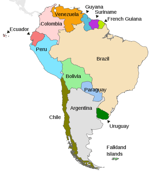
Map depicting the countries on the continent of South America.
Natural Geography of Suriname
Geographic Regions
The natural landscape of Suriname consists of rainforests, savanna, coastal swamps, and the two main mountain ranges: the Bakhuis and Van Asch Van Wijck Mountains. The country is situated on the Guiana Shield, one of the three cratons of the South American Plate. It can be divided into three main geographic regions:
- North: Lowland Coastal Plain
- Interior and South: Tropical Rainforest and Savanna
- Far South: Highlands
Northern: Coastal Plain
The coastal plain is flat and sometimes as much as 1.5 m (5 ft) below sea level, necessitating a system of sea defenses. In addition, the soils of the coastal plain are relatively fertile. The narrow coastal zone, approximately 386 km (239 mi) in width, consists of sandbanks and mudbanks. This sediment was deposited by the southern equatorial currents from the area surrounding the mouth of the Amazon River, located on the Brazilian coast to the south.
Further inland and south of the mudbanks, the "New Coastal Plain" begins, which was also formed from sand and clay from the mouth of the Amazon. This region consists of clay swampland in which peat has developed and is traversed by sandy ridges that run parallel to the coast. South of the New Coastal Plain is the "Old Coastal Plain," which consists primarily of fine clays and sands. This Old Coastal Plain contains a variety of topographies, including old ridges, clay flats, and swamps.
Paramaribo: the capital city and surrounding areas are home to almost half the country's population.
West Coast: known for its birdlife, Bigi Pan Nature Reserve, and a few towns.
East Coast: home to former colonial plantations and sea turtle nesting beaches.
Interior: Rainforest and Savanna
The interior rainforest region covers the central and southern parts of Suriname. It is part of the vast Amazon Rainforest, characterized by dense tropical rainforests, rich biodiversity, and numerous rivers and creeks. Within the interior rainforest region are areas of savannas characterized by grasslands and scattered trees. The savannas contrast the dense rainforests and provide essential grazing areas for wildlife and cattle. This region is sparsely populated, with indigenous communities and small settlements scattered throughout the rainforest.
The interior rainforest is of significant ecological importance and is home to various plant and animal species, including jaguars, monkeys, and rare bird species. In the upper Coppename River watershed, the Central Suriname Nature Reserve is a UNESCO World Heritage Site, cited for its unspoiled rainforest biodiversity.
Southern: Guiana Highlands
Even farther south, bordering Brazil is an area consisting mainly of a central mountain range along with its branches and scattered hilly regions. A vast tropical rainforest covers these highlands. The Guiana Highlands form a part of the larger Guiana Shield, a geological formation that extends across several South American countries.
The Guiana Highlands are characterized by rugged mountains, tepuis (tabletop mountains), and plateaus. Some of the notable tepuis in this region include Tafelberg and Voltzberg. The highlands have unique ecosystems and mineral resources, attracting scientific and mining interests. In the southwest, near the Brazilian border, lies the Sipaliwini Plain, another savanna.
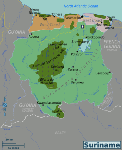
Map illustrating the regions of Suriname.
Landforms
Low-lying coastal plains and dense rainforests primarily characterize Suriname's terrain, which lacks extensive mountain ranges. However, some notable highlands and isolated mountains exist, particularly within the larger Guiana Highlands.
The main mountain ranges in Suriname include:
Wilhelmina Mountains: The Wilhelmina Mountains, also known as the Wilhelminagebergte, are located in the southern part of Suriname within the Sipaliwini District. This mountain range is part of the more extensive Guiana Highlands, which extend across several South American countries. The Wilhelmina Mountains are home to Suriname's highest peak, Juliana Top (Juliana Peak), reaching an elevation of approximately 1,280 m (4,200 ft) above sea level. The range is known for its biodiversity, with various plant and animal species in its rainforests.
Kasikasima Range: The Kasikasima Range is in southern Suriname, specifically within the Tumuk Humak Mountains. Mount Kasikasima, one of the tallest peaks in the country, is part of this range, standing at an elevation of about 718 m (2,356 ft) above sea level. The remote area is home to indigenous communities, making it an important cultural and ecological region.
Tafelberg Range: The Tafelberg Range is not an extensive mountain range but a notable tepui (tabletop mountain) in central Suriname. Tafelberg, also known as Table Mountain, is one of the most recognizable tepuis in the country. It is approximately 1,026 m (3,366 ft) above sea level and features a flat tabletop summit, typical of tepuis. Tafelberg is in a pristine rainforest area and offers unique hiking and exploration opportunities.
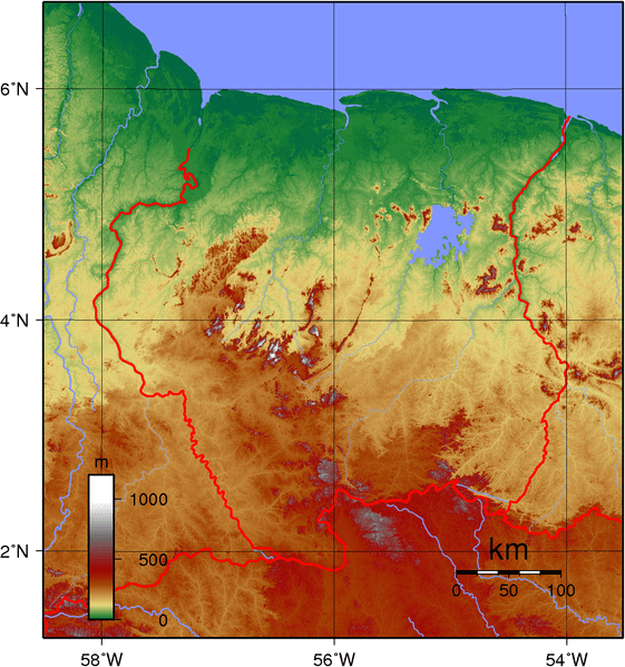
Map depicting the topography of Suriname.
Bodies of Water
Many of Suriname's water bodies are ecologically significant, providing habitats for various plant and animal species. Wetlands, mangroves, and riverine ecosystems support multiple forms of aquatic life. Suriname is characterized by several significant rivers that play crucial roles in its geography and development. Many rivers are used as natural transportation routes, supporting trade and connecting remote communities with urban centers. The country has a relatively short coastline along the Atlantic Ocean. It features several coastal lagoons, estuaries, and wetlands.
See more: Water Bodies of Suriname
Islands
Suriname has a few islands, although they are primarily small and uninhabited. The largest island in Suriname is Bigi Speight Island, located in the Atlantic Ocean, about 15 km (9 mi) off the coast. It has an uninhabited area of about four sq km (1.5 sq mi). The island is primarily covered in mangroves and is a popular nesting ground for seabirds.
Other islands off the coast of Suriname include:
- Klein Speight Island
- Long Island
- Goat Island
- Rabbit Island
These islands are also uninhabited and are mainly used for fishing and recreation.
Administrative Divisions
Suriname is divided into ten administrative districts: the two urban districts of Paramaribo (the capital) and Wanica, six rural districts in the coastal area, and two in the interior.
See more: Cultural Landscape of Suriname
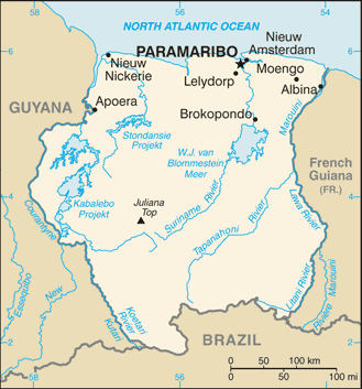
CIA Map of Suriname.
Natural Regions
Ecological Regions
Suriname is situated in the Neotropical realm. Ecoregions are classified by biome type - the major global plant communities determined by rainfall and climate. In addition, the country contains six terrestrial ecoregions.
Tropical and subtropical moist broadleaf forests:
Guianan Highlands moist forests
Paramaribo swamp forests
Pantepui forests and shrublands
Tropical and subtropical grasslands, savannas, and shrublands:
Mangroves:
Guianan mangroves