Honduras: Natural Landscape
Honduras, located in northern Central America, is mostly mountainous. Lowlands are situated along its Pacific and Caribbean coasts and the river valleys of the interior. Most of the population resides in the central highlands, an economically important agricultural region.

, https://www.flickr.com/photos/josiah_townsend/4785522034")
, https://www.flickr.com/photos/35653698@N06/12141415734")
, https://www.flickr.com/photos/48096653@N00/3532534772")


, https://www.flickr.com/photos/youngrobv/510695746")

, https://www.flickr.com/photos/bz3rk/4739795830")
, https://www.flickr.com/photos/waterdotorg/19747498145")

The Natural Landscape of Honduras
Honduras, located in northern Central America, borders Nicaragua to the southeast, El Salvador and the Pacific Ocean to the southwest, Guatemala to the west, and the Caribbean Sea to the north. This strategic positioning places Honduras at the crossroads of diverse geographical and cultural influences within the region.
As the second-largest country in Central America, Honduras encompasses an expansive land area of approximately 112,090 square kilometers (43,300 square miles). This includes the Bay Islands, scattered in the Gulf of Honduras along its extensive 700-kilometer (430-mile) Caribbean coastline, adding a distinct maritime dimension to the nation's geography.
Honduras's topography is predominantly mountainous, with lowlands primarily distributed along the coasts or nestled within river valleys. The Gulf of Fonseca, stretching across 153 kilometers (95 miles) in the southwest, delineates the country's Pacific coastline, contributing to the diverse coastal landscapes that define Honduras. This coastal diversity, coupled with the presence of the Bay Islands, underscores the country's rich natural assets and significance as a bridge between the Caribbean and the Pacific.
Biodiversity
Honduras is a haven of biodiversity, its richness stemming from a diverse landscape mosaic encompassing tropical rainforests, cloud forests, coastal areas, and expansive mountain ranges. This ecological diversity nurtures a vast array of flora and fauna, making Honduras a notable reservoir of life.
The Honduran Ministry of Environment, MiAmbiente, meticulously catalogs the nation's biodiversity, revealing an impressive array: 7,524 registered species of vascular plants, 718 bird species, 228 mammal species, 211 reptile species, 111 amphibian species, 2,500 insect species, and 672 fish species.
Conservation
Acknowledging the intrinsic value of the country's natural heritage, Honduras has made strides in conservation by establishing protected areas and national parks. The Río Plátano Biosphere Reserve, Cusuco National Park, Pico Bonito National Park, and Nombre de Dios National Park play pivotal roles in safeguarding the country's unique ecosystems.
However, Honduras confronts formidable challenges, including deforestation, habitat degradation, and the illegal wildlife trade. Despite these challenges, conservation organizations and local communities are actively engaged in addressing these issues. Their efforts aim to counteract threats to biodiversity and promote sustainable land use and conservation practices. Through these collective endeavors, Honduras strives to balance the preservation of its natural treasures with the needs of its growing population, fostering a harmonious coexistence between human development and ecological conservation.
Climate
Honduras has a tropical climate characterized by well-defined wet and dry seasons. The wet season, which spans May to October, witnesses substantial rainfall and aligns with hurricane season. Conversely, the dry season, which runs from November to April, offers more favorable weather conditions for tourism and outdoor activities.
Elevation influences temperature fluctuations, contributing to microclimates and diverse rainfall patterns across the country. In the coastal lowlands, temperatures average between 26 - 29 °C (79 - 84 °F) annually, while in the highlands, the range is 16 - 24 °C (61 - 75 °F).
The tropical coastal lowlands exhibit a generally hot climate with high humidity, gradually transitioning to more temperate conditions as elevation increases toward the interior. Despite these climatic nuances, Honduras faces the risk of natural disasters such as hurricanes, tropical storms, and flooding, emphasizing the dynamic interplay between geographical features and climate challenges in the region.
Volcanism
Situated within the seismic hotspot of the Pacific Ring of Fire, Honduras bears the geological imprint of tectonic activity, manifesting in a history of volcanic phenomena. Although the country lacks active volcanoes, its landscape reveals the echoes of past volcanic events, and ongoing geothermal activity is intricately linked to its tectonic setting.
While Honduras doesn't presently experience eruptions, the potential for future volcanic activity underscores the country's dynamic geological context. Geothermal activity, a testament to the region's subsurface heat, has sparked conversations about leveraging this energy source for electricity generation in the years to come. Exploring the harnessing of geothermal energy reflects an innovative approach to sustainable power generation. It emphasizes Honduras's commitment to embracing its geological assets for practical and environmentally conscious advancements in the future.
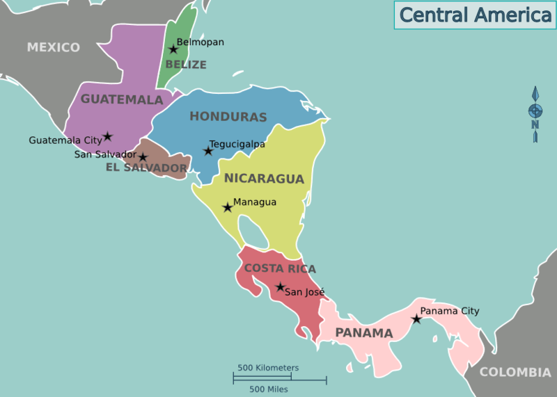
Location map of the countries of Central America.
Natural Geography of Honduras
Topography
Honduras features a strikingly diverse and rugged topography. Over 75% of its land is dominated by mountainous terrain. This rugged landscape is interspersed with coastal lowlands along the Pacific and Caribbean coasts and interior river valleys, offering a dramatic contrast between elevations and flatlands.
The interior highlands form the core of the country’s geography. They are characterized by a network of undulating valleys, ridges, and smaller peaks, creating a dynamic topographical mosaic that defines much of Honduras. The predominant alignment of surface features follows an east-to-west orientation, shaping the country’s natural and cultural landscapes and influencing patterns of settlement and agriculture.
In the southwest, the Volcanic Highlands present some of Honduras' most dramatic elevations. This region is home to the nation’s highest peaks, including Pico Congolón, which rises to 2,500 m (8,200 ft), and Cerro Las Minas, the highest point at 2,850 m (9,350 ft). These peaks, surrounded by lush forests and deep valleys, provide a breathtaking backdrop and play a significant role in the country's ecology and economy.
The coastal lowlands offer a contrasting terrain, with the flat expanses of the Caribbean and Pacific coasts giving way to mangroves, beaches, and river deltas. The mountains, valleys, and coastal plains create a diverse topographical tapestry reflecting Honduras’ natural beauty and geographical complexity, shaping its climate, ecosystems, and human activities.
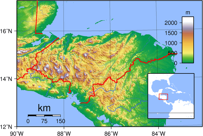
Topographic map of Honduras
Geographic Regions
Honduras, a Central American nation known for its diverse landscapes, can be broadly divided into three geographic regions: the Caribbean Lowlands, the Interior Highlands, and the Pacific Lowlands. Each region boasts unique natural features, cultural significance, and economic contributions, collectively shaping the country's identity.
Caribbean Lowlands
The Caribbean Lowlands stretch along the northern coast of Honduras, bordered by the Caribbean Sea. This region is characterized by extensive coastal plains, tropical rainforests, and mangroves, making it one of the most biologically diverse areas in the country. The Caribbean Lowlands include the Mosquitia region, home to the Río Plátano Biosphere Reserve, a UNESCO World Heritage Site known for its pristine rainforests and endemic species.
The coastline features the vibrant cities of La Ceiba, Tela, and Puerto Cortés, which are vital hubs for tourism, shipping, and agriculture. La Ceiba is Honduras's eco-tourism capital, offering access to the Pico Bonito National Park and Cuero y Salado Wildlife Refuge. Additionally, the region encompasses the Bay Islands, including Roatán, Utila, and Guanaja, renowned for their white-sand beaches and proximity to the Mesoamerican Barrier Reef, the second-largest coral reef system in the world. The lowlands are also home to the Garífuna communities, whose Afro-Caribbean culture adds to the region's vibrant identity through music, dance, and traditional cuisine.
Interior Highlands
The Interior Highlands dominate most of Honduras' land area, covering the central and western regions. Rugged mountain ranges, deep valleys, and fertile basins define this area, starkly contrasting it to the lowland regions. Cerro Las Minas, the country's highest peak, is located in this region, reaching 2,870 meters (9,416 ft). The cooler climate of the highlands supports coffee cultivation, one of Honduras' main exports, and other agricultural activities like corn and bean farming.
The Sula Valley, nestled within the highlands, is a vital economic zone due to its agricultural productivity and the industrial city of San Pedro Sula, often referred to as Honduras' economic capital. The Western Highlands hold great historical and cultural significance, particularly as the site of Copán, a well-preserved ancient Maya city known for its intricate stelae and hieroglyphic stairway. The highlands are also home to colonial towns like Comayagua, the former capital of Honduras, which features well-preserved Spanish architecture and historic churches. Tegucigalpa, the national capital, lies within a highland valley and serves as the nation's political and cultural center.
Pacific Lowlands
The Pacific Lowlands are located in southern Honduras, bordering the Gulf of Fonseca. This smaller region contrasts with the expansive Caribbean Lowlands but plays an essential role in the country's economy and ecology. The lowlands are characterized by fertile plains, volcanic landscapes, and mangrove forests, which provide critical habitats for a variety of bird species and marine life.
The port city of San Lorenzo is the main urban center in this region and a vital economic hub for trade through the Gulf of Fonseca. The surrounding agricultural lands are highly productive, yielding crops such as melons and shrimp for export. The Gulf is dotted with small islands and coastal villages where fishing is a primary livelihood. The warm climate, scenic beaches, and tranquil mangroves attract visitors seeking a quieter escape than the Caribbean coast.
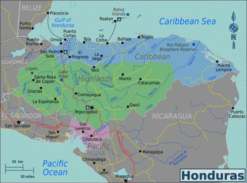
Map depicting the geographic regions of Honduras.
Islands and Archipelagos
Honduras has a diverse coastal geography, including several notable islands and archipelagos in the Bay of Honduras and the Caribbean Sea. The country's islands and archipelagos offer unique landscapes, cultural experiences, and natural wonders for visitors to explore.
See more: Islands and Archipelagos of Honduras
Bodies of Water
Honduras boasts diverse bodies of water that significantly contribute to the country's natural beauty, biodiversity, and economy. The country is bordered by the Caribbean Sea along its northern coastline, with several notable features. The Gulf of Honduras, a vast body of water shared by Honduras, Belize, Guatemala, and a portion of Mexico, acts as a vital transportation route for shipping and trade. The country is also graced with picturesque bays and lagoons, such as Trujillo Bay and Laguna de Alvarado, offering serene coastal landscapes and supporting various marine life.
See more: Water Bodies of Honduras
Administrative Divisions
Honduras is administratively divided into 18 departments and 298 municipalities. Each department is headed by a governor appointed by the President of Honduras.
See more: Cultural Landscape of Honduras
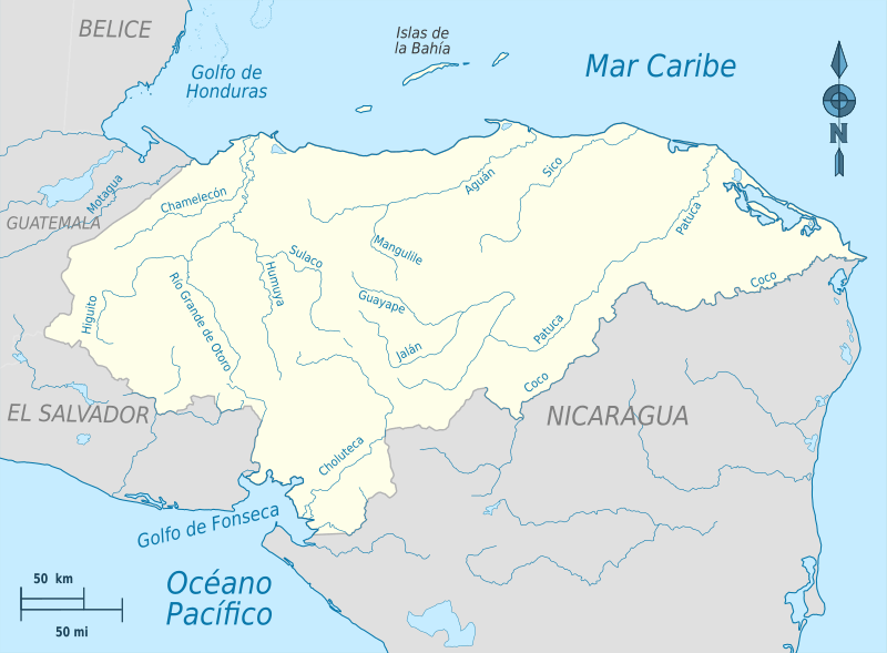
Hydrographic map of Honduras
Natural Regions
Honduras's natural landscape includes rainforests, cloud forests, mangroves, savannas, and mountain ranges with pine and oak trees. In addition, its Caribbean coast in the north hosts a portion of the Mesoamerican Barrier Reef System.
Ecological Regions
The following is a list of terrestrial ecoregions in Guatemala, as defined by the World Wide Fund for Nature (WWF). Guatemala is in the neotropical realm. Ecoregions are classified by biome type—the major global plant communities determined by rainfall and climate.
Tropical and subtropical moist broadleaf forests
Central American Atlantic moist forests
Central American montane forests
Tropical and subtropical dry broadleaf forests
Tropical and subtropical coniferous forests
Central American pine–oak forests
Miskito pine forests
Mangroves
Gulf of Fonseca mangroves
Northern Honduras mangroves
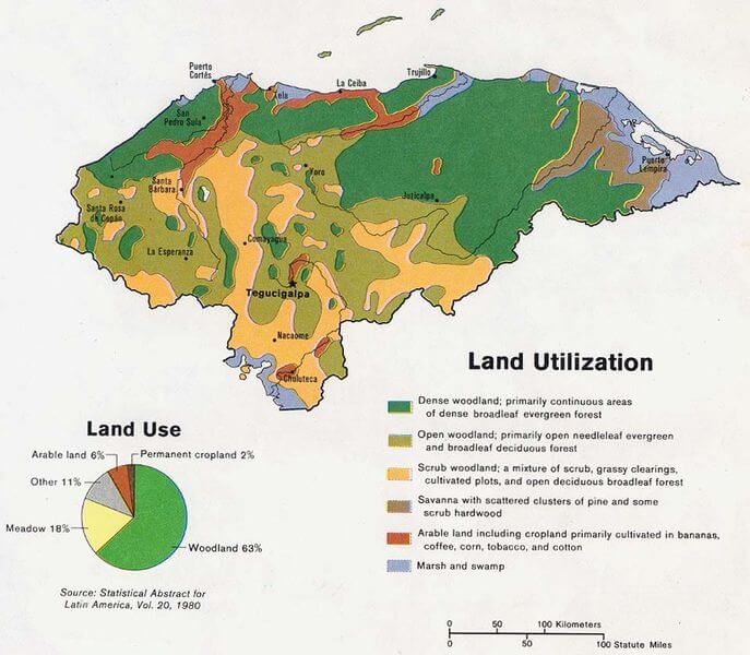
Land use map of Honduras.