Mexico: Natural Landscape
Mexico is located in the southern portion of North America and is the third largest country in Latin America. A biodiverse country, it encompasses arid deserts and scrublands, tropical rainforests, temperate forests and grasslands, mangrove swamps, alpine ecosystems, and coral reefs.
 https://www.flickr.com/photos/elisfanclub/6971697331")


 https://www.flickr.com/photos/royluck/6804405972")
, https://www.flickr.com/photos/146321178@N05/33711794428/in/photostream/")
 https://www.flickr.com/photos/waywuwei/4046898365")

 https://www.flickr.com/photos/kateyaeger/4036637702/")
, https://www.flickr.com/photos/cimmyt/5755745202")


Mexico's Diverse Landscapes: A Land of Volcanoes, Deserts, and Rainforests
Located in southern North America, Mexico is a land of striking geographical contrasts, ranging from towering volcanic peaks and arid deserts to lush tropical rainforests and extensive coastlines. Bordered by the United States to the north and Guatemala and Belize to the southeast, the country is flanked by three major bodies of water: the Pacific Ocean to the west, the Gulf of Mexico to the east, and the Caribbean Sea along the Yucatán Peninsula. Mexico's vast land area of approximately 1,972,550 sq. km (761,610 sq. mi) makes it the 13th-largest country in the world and the third-largest in Latin America, following Brazil and Argentina. Beyond the mainland, numerous islands and archipelagos further enrich its diverse landscape.
Mexico's geological complexity is shaped by its position atop three major tectonic plates: the North American Plate, the Cocos Plate, and the Pacific Plate. This unique location contributes to Mexico's rugged topography and active volcanism and makes it one of the most seismically dynamic regions on Earth. The combination of these geological forces, diverse ecosystems, and varied climate zones has resulted in one of the most biologically and geographically complex nations in the world.
Biodiversity
Mexico is recognized as one of the world's megadiverse countries, home to an extraordinary array of ecosystems and species. The country's biodiversity is a product of its vast range of climates, elevations, and geographic features. From the arid deserts of the north to the dense tropical rainforests of the south, Mexico's varied terrain supports an unparalleled wealth of life.
Ranking among the top five nations globally in species diversity, Mexico boasts an estimated 23,385 plant species, 1,105 bird species, 533 mammal species, 988 reptile species, and 411 amphibian species. It has the highest number of reptile species of any country and is among the leading nations in mammal and plant diversity. The convergence of the Neotropical and Nearctic biogeographic regions within its borders creates an environment where species from both North and South America coexist, further amplifying its ecological richness.
Many of these species are endemic, found nowhere else on Earth. The diverse ecosystems, which include cloud forests, mangroves, coral reefs, and temperate woodlands, serve as crucial habitats for species such as the jaguar, axolotl, vaquita porpoise, and resplendent quetzal. However, Mexico's biodiversity is increasingly threatened by deforestation, habitat fragmentation, and climate change, necessitating extensive conservation efforts.
Conservation
Mexico has made significant strides in protecting its rich biodiversity through the establishment of national parks, biosphere reserves, and marine protected areas. The government has designated over 182 natural protected areas, covering approximately 90 million hectares (347,000 sq. mi) of land and ocean territory. Prominent among these are the Monarch Butterfly Biosphere Reserve, which shelters millions of migrating butterflies each winter, the Sian Ka'an Biosphere Reserve, a UNESCO World Heritage Site home to diverse marine and terrestrial ecosystems, and the Sierra Gorda Biosphere Reserve, which safeguards a broad spectrum of flora and fauna across its mountainous terrain.
Despite these efforts, conservation faces challenges from deforestation, illegal wildlife trade, and pollution. Expanding agriculture and urban development have led to habitat destruction, particularly in tropical forests and coastal regions. In response, Mexico has strengthened environmental policies, promoted ecotourism initiatives, and collaborated with international organizations to enhance conservation strategies. As a signatory to the Convention on Biological Diversity, the country plays a pivotal role in global efforts to preserve the planet's ecological balance.
Climate
Mexico's climate is shaped by its varied topography, latitude, and proximity to oceans, resulting in a wide spectrum of weather conditions. The country is divided into three principal climate zones: tropical, temperate, and arid.
The tropical climate dominates the coastal regions and much of southern Mexico. Temperatures remain warm year-round, averaging between 25 and 30 °C (77 and 86 °F). Rainfall is abundant, particularly from May to October, sustaining lush rainforests and fertile agricultural lands. The Yucatán Peninsula, with its low-lying terrain and humid conditions, experiences frequent tropical storms and hurricanes.
The temperate climate prevails in central Mexico, including the high-altitude regions of the Mexican Plateau and surrounding mountain ranges. Cities such as Mexico City and Guadalajara enjoy moderate temperatures ranging from 15 to 25 °C (59 to 77 °F), with a rainy season from June to September. These regions support dense forests of pine and oak, as well as some of the most densely populated areas of the country.
The arid climate characterizes much of northern Mexico and the Baja California Peninsula, where rainfall is scarce and temperatures fluctuate significantly. In regions such as the Sonoran Desert and Chihuahuan Desert, summer temperatures can exceed 40 °C (104 °F), while winter nights often drop below freezing. The harsh climate presents challenges for agriculture, but cacti, succulents, and drought-resistant species have adapted to survive in these extreme conditions.
Microclimates further add to Mexico's climatic diversity. The Sierra Madre mountain ranges create cooler conditions at higher elevations, supporting unique cloud forests, while coastal upwellings along the Pacific generate temperate marine environments. This climatic variation influences agriculture, biodiversity, and human settlement patterns across the country.
Volcanism
As part of the Pacific Ring of Fire, Mexico is one of the most volcanically active regions in the world. The Trans-Mexican Volcanic Belt, stretching from the Pacific to the Gulf of Mexico, is home to numerous volcanoes, some of which remain highly active. The country's volcanic history has shaped its landscape, producing fertile soils that support agriculture and contributing to geothermal energy production.
Popocatépetl, located near Mexico City, is one of the most closely monitored volcanoes due to its frequent eruptions and potential risk to surrounding populations. Colima, also known as Volcán de Fuego, is another highly active volcano that regularly produces ash clouds and lava flows. Other prominent volcanoes include Iztaccíhuatl, a dormant twin-peaked formation, and Nevado de Toluca, which features crater lakes at high altitudes.
Mexico also has several extinct or long-dormant volcanoes, such as La Malinche and Cofre de Perote, which no longer pose an eruption risk but remain significant landmarks. Despite the dangers posed by active volcanism, the geothermal potential of these regions has been harnessed for renewable energy, with Mexico ranking among the top countries in geothermal electricity production.
To mitigate the risks associated with volcanic activity, the country has implemented early warning systems and continuous geological monitoring. Institutions such as the National Center for Disaster Prevention (CENAPRED) play a crucial role in assessing potential threats and preparing local communities for possible eruptions.
Conclusion
Mexico's natural landscape is one of remarkable contrasts and ecological richness. From its towering volcanoes and expansive deserts to its tropical forests and coastal ecosystems, the country's diverse geography and climate have shaped a unique and dynamic environment. Its position on multiple tectonic plates has made it a land of geological activity, while its location at the crossroads of biogeographic regions has fostered one of the most biodiverse ecosystems on the planet.
Although Mexico faces environmental challenges, significant conservation efforts and sustainable initiatives continue to safeguard its natural heritage. By balancing ecological preservation with economic development, the country remains a critical player in global biodiversity conservation. Its landscapes not only define its physical identity but also sustain the cultural and natural wealth that makes Mexico one of the most fascinating countries in the world.
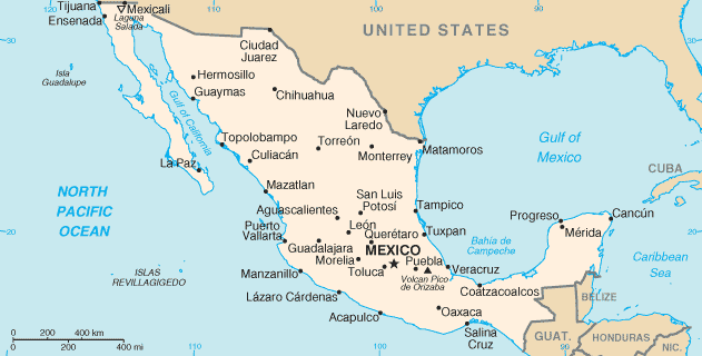
Location map of Mexico.
Mexico's Geographic Diversity: A Land of Mountains, Plateaus, and Coastal Plains
Mexico's geography is remarkably diverse. Its location between the Pacific Ocean and the Gulf of Mexico has shaped its landforms, and varied tectonic activity has sculpted its landforms. The country can be divided into nine distinct physiographic regions, each with unique characteristics that contribute to its rich natural heritage.
Baja California
Baja California is a rugged, arid peninsula in northwestern Mexico that extends parallel to the western coast. It is bordered by the Pacific Ocean to the west and the Gulf of California to the east, which separates it from mainland Mexico. The region's topography is dominated by the Peninsular Ranges, a series of mountains running along the spine of the peninsula. These mountains create a dramatic contrast with the surrounding desert plains.
Despite its harsh climate, characterized by minimal rainfall and extreme temperatures, Baja California supports diverse ecosystems, including xeric shrublands, coastal wetlands, and unique marine habitats. The region's isolation has also allowed for the evolution of distinct plant and animal species, some of which are found nowhere else in the world.
Pacific Coastal Lowlands
The Pacific Coastal Lowlands stretch along Mexico's western edge, extending approximately 1,450 km (900 mi) from the Colorado River delta in the north to the southern regions of the country. This region is framed by the Gulf of California to the west and the Sierra Madre Occidental to the east.
The terrain consists of coastal terraces, mesas, and river deltas, which shape the landscape and provide fertile ground for agriculture in select areas where irrigation is possible. The northern portion of the coastal plain is dominated by the Sonoran Desert, an arid expanse with extreme temperatures and sparse vegetation. However, human intervention, including extensive irrigation systems, has transformed parts of the region into productive farmland.
Mexican Plateau
The Mexican Plateau, also known as the Altiplano, is one of the most prominent landforms in Mexico. It occupies much of the country's interior and is enclosed by the Sierra Madre Occidental to the west and the Sierra Madre Oriental to the east. This vast plateau is characterized by arid and semiarid landscapes, and its elevation significantly influences temperature and precipitation patterns.
The plateau is divided into two sections: the Mesa del Norte (Northern Plateau), which is drier and more sparsely populated, and the Mesa Central (Central Plateau), which is home to some of Mexico's largest cities, including Mexico City and Guadalajara. Despite its arid conditions, the Mexican Plateau contains fertile valleys where agriculture thrives, particularly in areas with access to irrigation.
Sierra Madre Oriental
The Sierra Madre Oriental is a formidable mountain range that runs along the eastern side of the Mexican Plateau, extending approximately 1,000 km (620 mi) from the U.S.-Mexico border in Coahuila to the Trans-Mexican Volcanic Belt in Puebla. The range is characterized by rugged peaks, deep canyons, and extensive forested areas.
Composed mainly of folded sedimentary rocks, the Sierra Madre Oriental is geologically significant and harbors valuable mineral deposits, including copper, lead, and zinc. The region's climate varies with elevation, supporting a range of ecosystems from dry scrublands in the lower elevations to dense pine and oak forests at higher altitudes.
Sierra Madre Occidental
Parallel to the Pacific coast, the Sierra Madre Occidental extends approximately 1,250 km (780 mi) across northwestern and western Mexico. This range is part of the larger North American Cordillera and is known for its deep canyons, including Copper Canyon (Barranca del Cobre), one of the most extensive and dramatic canyon systems in the world.
The Sierra Madre Occidental plays a crucial role in Mexico's hydrology, as its slopes channel rainwater into rivers that provide essential water resources to arid regions. The range is also home to a variety of ecosystems, from arid highlands to temperate forests, making it an important area for biodiversity.
Trans-Mexican Volcanic Belt
The Trans-Mexican Volcanic Belt, also known as the Cordillera Neo-Volcánica, is an active volcanic region stretching approximately 1,000 km (620 mi) from the Pacific Ocean to the Gulf of Mexico. It is home to some of Mexico's most famous volcanoes, including Popocatépetl, Iztaccíhuatl, and Pico de Orizaba, the country's highest peak at 5,636 m (18,491 ft).
The volcanic belt is one of Mexico's most geologically dynamic areas. Frequent seismic activity and eruptions shape the landscape. South of the volcanic belt lies the Balsas Depression, a low-lying region characterized by a hot and dry climate. The presence of volcanic soil makes this region highly fertile, supporting extensive agriculture.
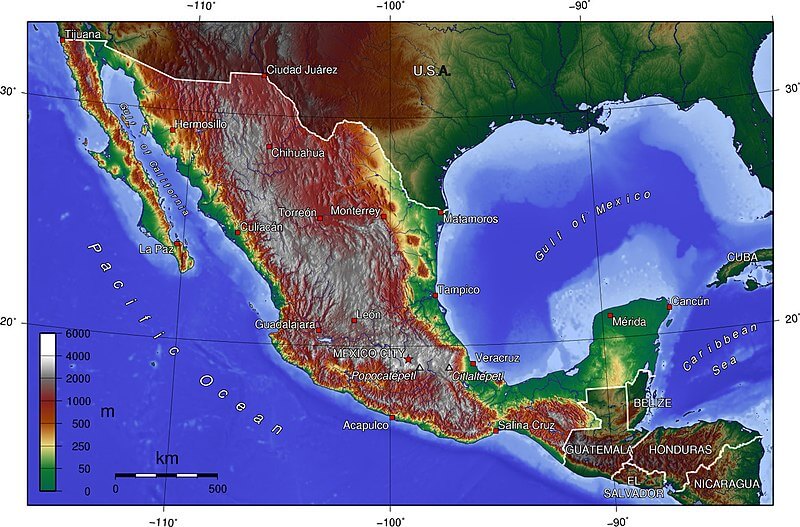
Topographic map of Mexico.
Gulf Coastal Plain
The Gulf Coastal Plain stretches approximately 1,450 km (900 mi) along the Gulf of Mexico, from the U.S. border to the Yucatán Peninsula. It encompasses the Tabasco Plain in the southeast and is marked by diverse geographical features, including lagoons, swamps, and river deltas.
In the north, the coastal plain is relatively broad, extending about 160 km (100 mi) inland. However, as it progresses southward, the Sierra Madre Oriental interrupts the plain, narrowing it before widening again near the Isthmus of Tehuantepec. The region's warm and humid climate supports dense vegetation and is particularly known for its rich wetlands, which serve as important habitats for migratory birds and marine life.
Southern Highlands
The Southern Highlands include the Sierra Madre del Sur, Mesa del Sur, and Sierra Madre de Chiapas, which form rugged terrain along Mexico's southern Pacific coast. The Sierra Madre del Sur features steep mountain ranges that often reach the coastline, creating dramatic cliffs and coves that define the region's famous Mexican Riviera.
Further inland, the Mesa del Sur is characterized by numerous valleys and eroded ridges, including the scenic Oaxaca Valley, a cultural and agricultural hub. The region is bisected by the Isthmus of Tehuantepec, the narrowest land passage between the Pacific Ocean and the Gulf of Mexico.
Further south, the Sierra Madre de Chiapas extends from Central America into Mexico, forming the primary watershed divide between rivers that flow into the Pacific and those that drain into the Gulf of Mexico. This region is known for its lush tropical forests and biodiversity and houses some of Mexico's most important ecological reserves.
Yucatán Peninsula
The Yucatán Peninsula is a low-lying limestone platform that separates the Gulf of Mexico from the Caribbean Sea. Its landscape is defined by sandy coastlines, coral reefs, and vast networks of underground rivers and cenotes (natural sinkholes), which result from the porous limestone bedrock.
The northern part of the peninsula is semi-arid, while the southern regions receive more rainfall and support tropical forests. The coastline varies dramatically, with the northern shore characterized by sandy dunes and the eastern Caribbean coast featuring cliffs and bays. The region is geologically young, and its surface lacks major rivers, as most water drains underground through the extensive cave systems.
Conclusion
Mexico's geography is a testament to its complex geological history and dynamic natural forces. From towering volcanic peaks to sprawling plateaus and arid deserts, the country's diverse landscapes have shaped its climate, ecosystems, and human settlement patterns. Each of Mexico's nine physiographic regions contributes to the nation's rich natural heritage, making it one of the most geographically varied countries in the world.
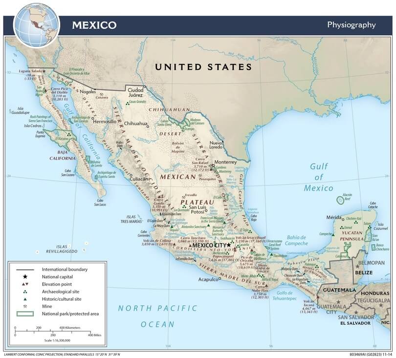
Mexico physiographic map.
Mountain Ranges
Mexico is one of the largest countries in the Americas and one of the most diverse in terms of geography, with a wide range of landscapes, including mountains, deserts, jungles, and coastal regions. Mexico's varied and complex topography features numerous mountain ranges and highlands that span its landscape.
See more: Mountain Ranges of Mexico
Islands and Archipelagos
Mexico boasts diverse islands and archipelagos scattered across its coastal waters in the Pacific Ocean and the Gulf of Mexico. These picturesque landmasses vary in size, culture, and ecological significance. From the Caribbean's white sandy beaches and crystal-clear waters to the unique ecosystems of the Pacific, Mexico's islands and archipelagos present a captivating mosaic of natural beauty and cultural heritage.
See more: Islands and Archipelagos of Mexico
Bodies of Water
Mexico is a country rich in bodies of water, encompassing various aquatic environments, from vast oceans and seas to lakes, rivers, and lagoons. In addition to its coastal regions, Mexico is home to numerous inland bodies of water.
See more: Bodies of Water of Mexico
Administrative Divisions
Mexico is a federal republic composed of 31 states. Each state has its congress and constitution. Mexico City is an autonomous entity. States are further divided into municipalities.
See: Cultural Landscape of Mexico
Natural Regions
Mexico is a biodiverse country. It encompasses arid deserts and scrublands, tropical rainforests, temperate forests and grasslands, mangrove swamps, alpine ecosystems, and coral reefs. This multitude of ecosystems supports wide-ranging biodiversity. For example, Mexico has over 200,000 species and is home to 10 - 12% of the world's biodiversity.
Principal Ecosystems
- Tropical evergreen forest (rainforest)
- Tropical deciduous and semideciduous forest
- Xeric shrubland
- Desert
- Grassland
- Coniferous forest
- Cloud forest
- Mangrove forests
- Wetlands
Biomes
Ecoregions are classified by biome type - the major global plant communities determined by rainfall and climate. Mexico spans both the Nearctic and Neotropical realms.
- Deserts and xeric shrublands
- Mangroves
- Mediterranean forests, woodlands, and scrub
- Temperate coniferous forests
- Temperate broadleaf and mixed forests
- Tropical and subtropical dry broadleaf forests
- Tropical and subtropical moist broadleaf forests
- Tropical and subtropical coniferous forests
- Tropical and subtropical grasslands, savannas, and shrublands
- Flooded grasslands and savannas
- Montane grasslands and shrublands
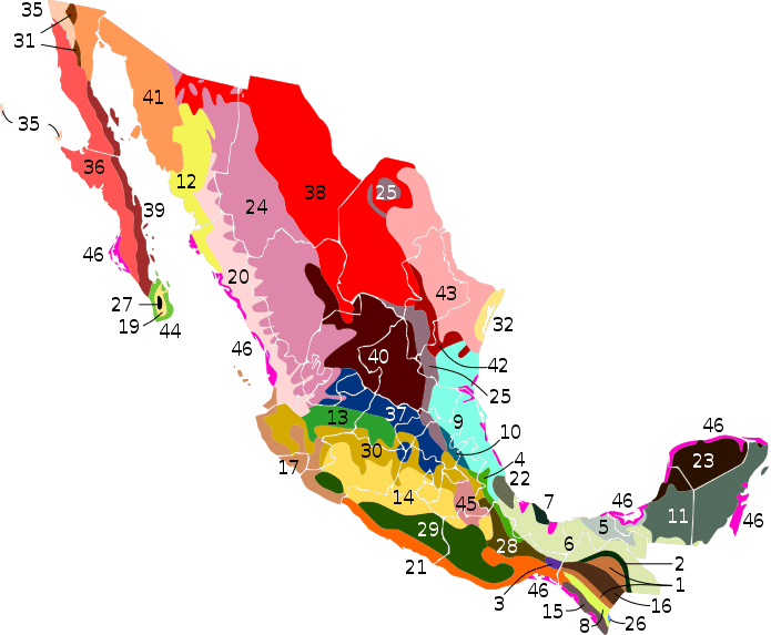
Map of the terrestrial ecoregions of Mexico
Ecological Regions
The following is a list of terrestrial ecoregions in Mexico, as defined by the World Wide Fund for Nature (WWF).
Terrestrial Ecoregions (map location key)
1 - Central American Pine–Oak forests
2 - Chiapas Montane Forests
3 - Chimalapas Montane Forests
4 - Oaxacan Montane Forests
6 - Petén-Veracruz Moist Forests
7 - Sierra de los Tuxtlas
8 - Sierra Madre de Chiapas Moist Forests
9 - Veracruz Moist Forests
10 - Veracruz Montane Forests
12 - Sonoran-Sinaloan Transition Subtropical Dry Forest
13 - Bajío Dry Forests
14 - Balsas Dry Forests
15 - Central American Dry Forests
16 - Chiapas Depression Dry Forests
17 - Jalisco Dry Forests
18 - Islas Revillagigedo Dry Forests (not shown)
19 - Sierra de la Laguna Dry Forests
20 - Sinaloan Dry Forests
21 - Southern Pacific Dry Forests
22 - Veracruz Dry Forests
23 - Yucatán Dry Forests
24 - Sierra Madre Occidental Pine–Oak Forests
25 - Sierra Madre Oriental Pine–Oak Forests
26 - Central American Montane Forests
27 - Sierra de la Laguna Pine–Oak Forests
28 - Sierra Madre de Oaxaca Pine–Oak Forests
29 - Sierra Madre del Sur Pine–Oak Forests
30 - Trans-Mexican Volcanic Belt Pine–Oak Forests
31 - Sierra Juárez and San Pedro Mártir Pine–Oak Forests
32 - Tamaulipan Pastizal (Western Gulf Coastal Grasslands)
33 - Central Mexican Wetlands (not shown, too small)
34 - Zacatonal (not shown, too small)
35 - California Coastal Sage and Chaparral
37 - Central Mexican Matorral
38 - Chihuahuan Desert
39 - Gulf of California Xeric Scrub
40 - Meseta Central Matorral
41 - Sonoran Desert
42 - Tamaulipan Matorral
43 - Tamaulipan Mezquital
44 - San Lucan Xeric Scrub
45 - Tehuacán Valley Matorral
46 - Petenes Mangroves