The Yucatán Peninsula: A Living Testament to Time
Suspended between the Gulf of Mexico and the Caribbean, the Yucatán Peninsula is a remarkable geological and cultural region. This limestone platform spans three Mexican states—Campeche, Quintana Roo, and Yucatán—and extends into Belize and Guatemala.


The Sacred Geography of the Maya: Exploring the Yucatán Peninsula
Suspended between the azure waters of the Gulf of Mexico and the Caribbean Sea, the Yucatán Peninsula emerges as one of Earth's most extraordinary geological and cultural theaters. This vast limestone platform, encompassing approximately 181,000 square kilometers (70,000 square miles), extends its ancient arms across three Mexican states—Campeche, Quintana Roo, and Yucatán—while reaching southward into the heart of Belize and Guatemala. Here, in this remarkable convergence of land and sea, the very foundations of the Earth tell stories that span from cosmic catastrophe to human civilization, from primordial forests to sacred cenotes.
The Emerald Heart: The Maya Forest
Cloaking the peninsula in an endless tapestry of green, the Maya Forest stands as the second-largest tropical rainforest in the Americas, yielding only to the mighty Amazon. This magnificent ecosystem stretches across 35 million hectares (86.5 million acres) throughout Mexico, Guatemala, and Belize, with Mexico's portion covering approximately 5.4 million hectares (13.3 million acres). The forest breathes with an ancient rhythm, its canopy reaching skyward in cathedral-like arches that have sheltered countless generations of life.
Within this emerald realm, towering Cecropia trees and majestic Swietenia macrophylla (mahogany) create a multilayered universe where sunlight filters through in dappled patterns. The forest floor, carpeted with centuries of decomposing leaves, nurtures an extraordinary diversity of life. Here, the elusive Panthera onca (jaguar) moves like liquid shadow through the undergrowth, while overhead, the endangered Crax rubra (great curassow) calls from the canopy with its distinctive, haunting voice.
The Maya Forest represents far more than a collection of trees; it embodies a living library of biodiversity where over twenty distinct ecosystems interweave their stories. From the humid Petén jungles in the south to the drought-adapted dry forests of the northern peninsula, each habitat supports its own unique community of flora and fauna, creating a biological mosaic of unparalleled complexity.
Sacred Waters: The Cenote System
Beneath the peninsula's deceptively flat surface lies one of the world's most extraordinary hydrological systems. The entire Yucatán Platform rests upon a foundation of porous limestone, carved and sculpted over millions of years by the patient work of slightly acidic groundwater. This process, known as karstification, has created a vast underground cathedral of caves, caverns, and rivers that extends for thousands of kilometers beneath the surface.
The cenotes—from the Maya word "dzonot," meaning sacred well—serve as windows into this hidden aquatic world. These natural sinkholes, numbering in the thousands across the peninsula, reveal themselves as perfectly circular pools of crystal-clear water, their depths plunging into mysterious blue-black infinity. Some cenotes open dramatically to the sky, their limestone walls adorned with dangling roots and tropical vegetation, while others hide secretively within cathedral-like caves, their surfaces mirror-still and reflecting the stalactites above like inverted cathedrals.
The Ring of Cenotes, a semicircular arrangement of these natural wells, traces the buried rim of one of Earth's most significant geological features—the Chicxulub crater. This 200-kilometer (124-mile) diameter scar, now buried beneath 1 kilometer (0.6 miles) of limestone sediments, marks the impact site of the cosmic collision that forever changed our planet's destiny.
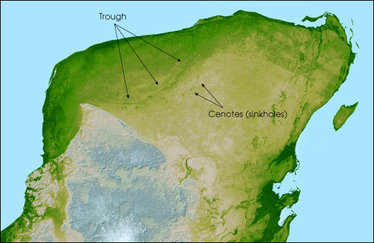
Relief map of the Yucatan Peninsula.
Echoes of Cosmic Catastrophe
Sixty-six million years ago, as the Cretaceous period drew to its close, a massive asteroid—perhaps 10 kilometers (6.2 miles) in diameter—screamed through Earth's atmosphere and struck the shallow seas that then covered the northern Yucatán. The impact unleashed forces beyond human comprehension, creating a crater larger than many countries and triggering a chain of events that would lead to the extinction of the non-avian dinosaurs and countless other species.
Today, this ancient wound lies hidden beneath layers of limestone, its presence revealed only through careful geological detective work and the telltale arrangement of cenotes that follow its buried rim. The Chicxulub crater represents one of the best-preserved impact structures on Earth, offering scientists an unparalleled window into the processes that have shaped our planet's history. The limestone bedrock itself bears witness to this cosmic violence, its shocked and fractured structure telling the story of temperatures that momentarily exceeded those found on the surface of the sun.
Climate and the Dance of Seasons
The peninsula's climate weaves its own complex narrative across the landscape. In the north, the Yucatecan plains experience a pronounced dry season, where the thorny embrace of deciduous tropical dry forest creates an almost desert-like landscape during the winter months. Here, species like the Pecari tajacu (collared peccary) and the Odocoileus virginianus (white-tailed deer) have adapted to survive in conditions where surface water becomes scarce, relying on the cenotes and their keen ability to locate hidden moisture sources.
Moving southward toward the Petén region of Guatemala, the climate gradually transforms, becoming more consistently humid and supporting the lush, moist forests that harbor the region's most spectacular biodiversity. This gradient creates a natural laboratory where species from different ecological realms meet and intermingle, creating zones of exceptional evolutionary creativity.
The peninsula's position within the Atlantic Hurricane Belt subjects it to the annual drama of the tropical storm season. These powerful weather systems, born in the warm waters of the Atlantic, can bring devastating winds and torrential rains that reshape the landscape in a matter of hours. Yet the region has evolved with these disturbances, and many species depend on the periodic rejuvenation that storms provide to the forest ecosystem.
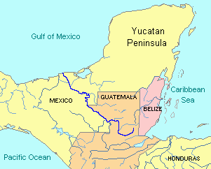
Political map of the Yucatan Peninsula.
A Mosaic of Life: Biodiversity Across Ecoregions
The Yucatán Peninsula's biodiversity unfolds across a complex tapestry of ecoregions, each adapted to specific environmental conditions. The Yucatán Moist Forests create dense, humidity-laden sanctuaries where epiphytes drape from every available surface and the Crax rubra finds refuge in the canopy's protective embrace. These forests serve as critical corridors for wildlife movement and genetic exchange across the broader Maya Forest system.
The Yucatán Dry Forests present a dramatically different face, their open, savanna-like structure dominated by drought-resistant species that shed their leaves during the dry season, creating landscapes that shift from green abundance to golden dormancy with the changing seasons. Here, the hardy Pecari tajacu forages among the thorny undergrowth, while the remarkable Tapirus bairdii (Baird's tapir) follows ancient pathways between water sources.
Along the coast, extensive mangrove systems create some of the most productive ecosystems on Earth. These salt-tolerant forests, dominated by Rhizophora mangle (red mangrove) and Avicennia germinans (black mangrove), serve as nurseries for countless marine species while protecting the coastline from storms and erosion. The mangroves pulse with life—juvenile fish dart between the prop roots, while Phoenicopterus ruber (American flamingos) filter-feed in the shallow lagoons.
Beneath the waves, the Mesoamerican Reef System creates underwater gardens of extraordinary beauty and complexity. This coral barrier, the second-largest reef system in the world, extends along the peninsula's Caribbean coast, supporting an incredible diversity of marine life from the microscopic to the magnificent. Here, Epinephelus striatus (Nassau grouper) patrol the reef walls, while Chelonia mydas (green sea turtles) glide gracefully through the crystal-clear waters.
The Living Legacy of the Maya
Throughout this natural wonderland, the architectural achievements of Maya civilization rise like dreams made of stone. Chichén Itzá, with its perfectly proportioned Pyramid of Kukulcán, demonstrates a sophisticated understanding of astronomy and mathematics that rivals any ancient civilization. The structure's design creates acoustic phenomena and shadow plays that mark the progression of the seasons, connecting human observation with cosmic cycles in ways that continue to inspire wonder today.
Uxmal's Palace of the Governor stretches across the landscape with mathematical precision, its facade adorned with intricate stone mosaics that speak to the Maya's extraordinary artistic vision. Meanwhile, Tulum perches dramatically on Caribbean cliffs, its walls having once protected one of the Maya's most important trading ports while serving as a lighthouse for ancient mariners navigating the treacherous reef systems offshore.
These archaeological treasures represent far more than tourist destinations; they are a testament to a civilization that achieved remarkable harmony with its natural environment. The Maya possessed an intimate understanding of the rhythms of the forest, the cycles of the cenotes, and the patterns of the stars, which enabled them to create sustainable communities in one of the world's most challenging tropical environments.
Conservation in an Era of Change
Today, the Yucatán Peninsula faces unprecedented challenges as modern development pressures meet ancient ecosystems. The Maya Forest, which once stretched unbroken across the region, now exists as a patchwork of protected areas surrounded by expanding agricultural lands and growing urban centers. Conservation efforts, including the expansion of the Calakmul Biosphere Reserve to over 1.3 million hectares (3.2 million acres), represent crucial steps toward maintaining the ecological integrity that has sustained this region for millions of years.
The cenote system, which provides freshwater for millions of people across the peninsula, faces threats from pollution, over-extraction, and development pressures. These sacred wells, revered by the ancient Maya as portals to the underworld, now serve as critical indicators of environmental health in an era of rapid change.
Conclusion: A Living Testament
The Yucatán Peninsula stands as a living testament to the power of deep time and the resilience of life. From the cosmic violence that created the Chicxulub crater to the patient work of water carving the cenote system, from the evolutionary creativity that filled the Maya Forest with its extraordinary biodiversity to the cultural achievements of Maya civilization, this remarkable region continues to inspire wonder and demand protection.
As we stand at the edge of a cenote, gazing into waters that have flowed unchanged for millennia, or walk beneath the forest canopy where jaguars still follow ancient pathways, we encounter a landscape that connects us to the deepest rhythms of our planet. The Yucatán Peninsula reminds us that we are part of a story much larger than ourselves—a story written in limestone and leaf, in starlight and sacred water, in the enduring dance between human culture and the natural world that sustains us all.