
The Gulf of Mexico: A Sea Shared by Latin America
The Gulf of Mexico is a semi-enclosed sea bordered by Mexico, Cuba, and the United States, whose warm waters connect the limestone shores of the Yucatán Peninsula to Cuba's westernmost point at Guanahacabibes and have shaped the economies, ecosystems, and coastal communities of Latin America's two largest Gulf nations for centuries.
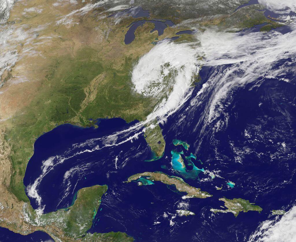
Golfo de México: Ancient Reefs, Shared Waters, One Sea Between Nations
In the warm waters between the Yucatán Peninsula and the Florida Keys lies one of the world's most economically and ecologically significant ocean basins. The Gulf of Mexico encompasses 1.6 million sq km (615,000 sq mi) of ocean bordered by three nations—Mexico, Cuba, and the United States—and has shaped the destiny of all three for centuries, supporting extraordinary biodiversity while fueling energy industries, fisheries, and coastal economies throughout the region. For Mexico and Cuba, Latin America's two Gulf nations, this semi-enclosed sea represents far more than a geographical feature—it embodies national sovereignty, economic development, and environmental stewardship challenges that continue to shape both countries' relationships with the sea.
Stretching from the Mississippi Delta to the coral reefs of the Mesoamerican Barrier Reef System, the Gulf represents a complex intersection of geological processes, biological evolution, and human enterprise spanning 300 million years of Earth's history. Mexican waters comprise roughly 38% of the Gulf's surface area, encompassing some of its most productive oil fields, most diverse coral ecosystems, and most culturally significant coastal regions, while Cuba's westernmost province of Pinar del Río fronts the Gulf directly across the Yucatán Channel, its protected coastline forming the sea's southeastern gateway.
Geological Genesis: The Deep Time Origins of a Continental Sea
The Gulf of Mexico's existence results from one of geology's most dramatic chapters—the breakup of the supercontinent Pangaea during the Late Triassic period, about 200 million years ago. As tectonic forces began pulling apart this massive landmass, a complex sequence of rifting, spreading, and subsidence created the basin that would eventually become the Gulf. The process involved the rotation of the Yucatán Peninsula away from its original position adjacent to what is now Louisiana and Texas, creating the distinctive shape that characterizes the Gulf today.
The basin's geological architecture reveals a story written in sediments and salt. Massive evaporite deposits, formed when ancient seas periodically dried up, created salt domes and diapirs that now influence both seafloor topography and hydrocarbon accumulation. These salt formations, some rising thousands of meters from the seafloor, create unique ecological niches while serving as geological traps that concentrate oil and natural gas deposits. The Mexican portion of the Gulf, particularly around the Bay of Campeche, contains some of the world's thickest sedimentary sequences, with over 15 km (9 mi) of accumulated sediments in some areas.
The Gulf's deepest point, the Sigsbee Deep, plunges to 4,384 m (14,383 ft) below sea level in an abyssal plain that covers much of the central Gulf. This deep-water environment, characterized by cold temperatures, high pressure, and unique geological features, supports specialized communities of deep-sea organisms while serving as a repository for sediments carried by rivers from across the North American continent. The contrast between these abyssal depths and the shallow continental shelves that surround much of the Gulf creates one of the world's most diverse marine topographies.
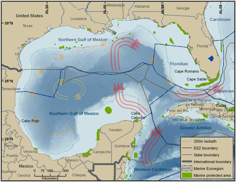
Marine environments and legal borders within the Gulf of Mexico.
Mexico's Marine Territory
Mexico's Gulf waters encompass approximately 615,000 sq km (237,000 sq mi) of marine territory, extending from the Río Bravo delta in Tamaulipas to the Yucatán Channel that connects the Gulf with the Caribbean Sea. This vast maritime domain encompasses some of the Gulf's most ecologically diverse and economically valuable regions, ranging from the shallow, coral-rich waters of the Campeche Bank to the deep, hydrocarbon-bearing formations of the Perdido Fold Belt along the United States maritime border.
The Mexican Gulf coast stretches over 3,200 km (2,000 mi), encompassing the states of Tamaulipas, Veracruz, Tabasco, Campeche, and Yucatán. Each coastal region presents distinct geological, ecological, and cultural characteristics that reflect the complex interplay between terrestrial and marine environments. The northern Mexican Gulf, influenced by the Río Bravo and other rivers draining the Sierra Madre Oriental, receives substantial freshwater and sediment inputs, creating productive estuarine environments. In contrast, the southeastern Mexican Gulf, dominated by the limestone platform of the Yucatán Peninsula, features crystal-clear waters, extensive coral reefs, and underground freshwater systems that discharge through coastal springs and cenotes.
Cuba's Western Gateway to the Gulf
At the Gulf's southeastern edge, Cuba's Pinar del Río province forms the sea's third national border, its Guanahacabibes Peninsula extending westward into open Gulf waters directly across the Yucatán Channel from Mexico's own coast. Cape San Antonio, at the peninsula's tip, is the westernmost point in Cuba, and the roughly 1,015 sq km (392 sq mi) Guanahacabibes Peninsula National Park and Biosphere Reserve, recognized by UNESCO in 1987, protects one of the most intact stretches of coastline anywhere on the Gulf. Its karst limestone terrain, riddled with sinkholes and caves in a landscape strikingly reminiscent of the Yucatán across the channel, supports over 700 plant species, 172 bird species (11 of them endemic), and nesting populations of loggerhead and green sea turtles, alongside offshore coral reefs and fishing grounds that supply much of the region's spiny lobster and red snapper.
Cuban researchers consider Guanahacabibes's surrounding waters an important source of larvae for fish, coral, and invertebrate populations that disperse northward into the wider Gulf, linking Cuba's conservation efforts directly to the health of fisheries as far away as the US Gulf Coast. Cuba has also explored for oil and natural gas within its own North Cuba Basin waters since the early 2000s, in partnership with foreign firms including Spain's Repsol and Russia's Zarubezhneft, though most exploratory wells have proven commercially marginal or technically difficult to develop, leaving Cuba's own Gulf hydrocarbon potential still largely unrealized in contrast to Mexico's prolific offshore fields. Rather than energy, it is this stretch of coastline's remoteness and ecological intactness, largely a product of decades of limited development, that defines Cuba's relationship with the Gulf today.
The Mesoamerican Reef System
The Mexican portion of the Gulf of Mexico contains the northern extent of the Mesoamerican Reef System, the world's second-largest coral reef system. Stretching from the Yucatán Peninsula to Honduras, this remarkable ecosystem supports extraordinary marine biodiversity while providing critical economic and environmental services to coastal communities. The Mexican section encompasses the Veracruz Reef System in the southwestern Gulf and portions of the Caribbean Reef System that extend into Gulf waters around Cozumel and the Yucatán Peninsula.
The Veracruz Reef System, located in the southwestern Gulf, encompasses 23 coral reefs distributed across approximately 52,000 hectares (128,000 acres) of marine territory. These reefs, built primarily by massive star coral (Orbicella faveolata), elkhorn coral (Acropora palmata), and brain corals (Diploria spp.), support over 2,500 marine species, including 300 fish species, 200 mollusk species, and 65 coral species. The reefs serve as nursery areas for commercially important fish species such as red snapper (Lutjanus campechanus), groupers (Epinephelus spp.), and various species of jacks (Caranx spp.).
However, these coral ecosystems face unprecedented threats from climate change, pollution, and coastal development. Rising sea temperatures have triggered multiple bleaching events in recent decades, while agricultural runoff from Mexican rivers introduces excessive nutrients and pesticides that disrupt coral metabolism and promote the growth of harmful algae. Coastal development associated with Mexico's growing tourism industry creates additional stressors through sedimentation, sewage discharge, and physical damage from boat anchors and recreational activities.
Marine Biodiversity: The Gulf's Living Treasury
The Gulf of Mexico supports one of North America's most diverse marine ecosystems, with over 15,419 documented species, ranging from microscopic plankton to the massive whale shark (Rhincodon typus). This remarkable biodiversity reflects the Gulf's complex geography, varied habitats, and position at the intersection of temperate and tropical biogeographic provinces. Mexican and Cuban Gulf waters contribute significantly to this diversity, particularly for tropical and subtropical species that reach their northernmost distributions in the warm waters of the Campeche Bank and Yucatán Shelf.
Marine mammals are among the Gulf's most charismatic faunal groups, with 29 species documented in Gulf waters. The endangered North Atlantic right whale (Eubalaena glacialis) uses Gulf waters as calving grounds, while sperm whales (Physeter macrocephalus) inhabit the deep waters of the central Gulf. Bottlenose dolphins (Tursiops truncatus) are year-round residents throughout the Gulf, with distinct populations in Mexican waters showing genetic differentiation from their northern counterparts. The West Indian manatee (Trichechus manatus), listed as vulnerable by the International Union for Conservation of Nature, inhabits coastal lagoons and river mouths along the Mexican Gulf coast, particularly in Tabasco and Campeche.
Sea turtles represent one of the Gulf's most important conservation challenges and success stories. Five of the world's seven sea turtle species nest on Gulf beaches in Mexico and Cuba alike, including the critically endangered Kemp's ridley (Lepidochelys kempii), which nests almost exclusively at Rancho Nuevo in Tamaulipas. This beach hosts one of the world's most remarkable wildlife spectacles, the synchronized mass nesting behavior known as arribada, where thousands of female turtles emerge simultaneously to lay eggs. Mexican conservation efforts, supported by international partnerships, have increased Kemp's ridley populations from fewer than 200 nesting females in the 1980s to over 10,000 today, representing one of the marine conservation world's greatest success stories.
The Gulf's fisheries represent critical economic and nutritional resources for coastal communities throughout the region. Traditional target species include red snapper, various grouper species, king mackerel (Scomberomorus cavalla), and Spanish mackerel (Scomberomorus maculatus). However, overfishing has severely impacted many commercial species, and red snapper populations in Mexican waters have declined by over 75% since the 1980s. Climate change exacerbates these pressures by altering species distributions, spawning timing, and food web dynamics that commercial fisheries depend upon.
The Dead Zone: A Shared Environmental Challenge
One of the Gulf of Mexico's most pressing environmental challenges is the formation of an annual hypoxic zone, commonly referred to as the "dead zone," which represents one of the world's largest human-caused environmental disasters. This area of severely depleted oxygen extends across 15,000 to 22,000 sq km (5,800 to 8,500 sq mi) during peak summer conditions, primarily in the northern Gulf. While the dead zone's center lies in United States waters, its effects extend across the Gulf and impact shared fish populations that migrate throughout the basin, including into Mexican and, to a lesser degree, Cuban waters.
The dead zone results from massive nutrient pollution, primarily nitrogen and phosphorus from agricultural fertilizers, municipal sewage, and industrial discharge carried by the Mississippi River system. These nutrients fuel explosive algal growth that depletes oxygen as the algae decompose, creating conditions that force marine life to flee or die. The ecological impacts extend far beyond the hypoxic zone itself, affecting Gulf-wide food webs and fish populations that fishing communities throughout the region depend upon.
Mexican rivers also contribute to Gulf nutrient pollution, though to a lesser extent than the Mississippi system. The Grijalva-Usumacinta river system, which drains much of southeastern Mexico and Guatemala, carries agricultural runoff and urban pollution from rapidly developing regions, while the Coatzacoalcos River in Veracruz transports industrial pollutants from Mexico's petrochemical corridor. Addressing the dead zone requires sustained international cooperation among all three Gulf nations, since the problem transcends political boundaries and affects marine resources shared across the entire basin.
Mexico's Petroleum Industry: The Gulf as Energy Epicenter
The Mexican portion of the Gulf of Mexico contains some of the world's most significant offshore oil reserves, with proven reserves exceeding 7 billion barrels of oil equivalent. These hydrocarbon deposits, formed over millions of years through the accumulation and transformation of organic matter in sedimentary basins, represent Mexico's most valuable natural resource and a cornerstone of the national economy.
The Cantarell Complex, located in the Bay of Campeche approximately 80 km (50 mi) northeast of Ciudad del Carmen, ranks among the world's most productive offshore oil fields. Discovered in 1976 and named after Mexican fisherman Rudesindo Cantarell, who first reported oil seeps in the area, this field complex has produced over 12 billion barrels of oil since production began in 1979. At its peak in 2004, Cantarell produced over 2 million barrels per day, making it briefly the world's second-largest oil field after Saudi Arabia's Ghawar field.
Cantarell's production has since declined dramatically due to natural reservoir depletion and technical challenges associated with maintaining pressure in aging wells, prompting PEMEX, Mexico's national oil company, to develop new exploration and production strategies, including deep-water projects in the Perdido area along the United States maritime boundary. The Ku-Maloob-Zaap complex, also in the Bay of Campeche, has since emerged as Mexico's most significant oil field, developed using advanced horizontal drilling and artificial lift technologies; production from Ku-Maloob-Zaap, combined with that from other Mexican Gulf fields, continues to account for approximately 70% of Mexico's total oil production. Mexico's 2013 energy reform opened the petroleum sector to private investment for the first time since the 1938 nationalization of the oil industry, attracting major international companies to bid on Mexican Gulf acreage and bringing new technology and capital to previously inaccessible deep-water and unconventional formations.
Coastal Communities: Where Land Meets Sea
The Mexican Gulf coast supports diverse communities whose livelihoods, cultures, and identities are deeply intertwined with marine resources and coastal environments, ranging from large industrial cities such as Veracruz and Coatzacoalcos to small fishing villages scattered along remote stretches of coastline in Campeche and Tabasco.
Veracruz, Mexico's oldest European settlement and most important Gulf port, exemplifies the deep historical connections between Mexican society and the Gulf of Mexico. Founded in 1519 by Hernán Cortés, Veracruz served as the primary gateway for Spanish colonial trade and cultural exchange between Europe and the Americas. Today, the Port of Veracruz handles approximately 20% of Mexico's total maritime cargo, making it a crucial link in North American trade networks. The city's colonial architecture, vibrant cultural traditions, and distinctive cuisine reflect centuries of international influence facilitated by its Gulf location.
Campeche, a UNESCO World Heritage site, preserves one of the Americas' finest examples of colonial fortified architecture while serving as the operational center for Mexico's offshore oil industry. The city's historic walls and bastions, built to protect Spanish treasure fleets from pirates, now overlook modern supply bases and helicopter pads serving PEMEX's offshore platforms.
Small-scale fishing communities along the Mexican Gulf coast, and around Cuba's Guanahacabibes Peninsula in Pinar del Río, have maintained traditional relationships with marine resources for generations. Villages in Tabasco and Campeche, as well as the sparsely populated fishing settlements of western Pinar del Río, practice artisanal fishing methods passed down through families, targeting species such as red snapper, grouper, and spiny lobster using techniques adapted to local environmental conditions. These communities possess detailed traditional ecological knowledge about fish behavior, seasonal patterns, and sustainable harvesting practices that complement scientific fisheries management efforts on both sides of the Yucatán Channel.
However, coastal communities throughout the Gulf face mounting pressures from environmental degradation, economic change, and climate impacts. Rising sea levels threaten low-lying settlements, while more frequent and intense hurricanes repeatedly damage to infrastructure and livelihoods. The decline of traditional fisheries forces many coastal residents to seek alternative employment, often leading to outmigration and the loss of traditional cultural knowledge.
Ocean Dynamics: Currents, Climate, and Circulation
The Gulf of Mexico's ocean circulation patterns have a profound influence on its ecological characteristics, climate impacts, and economic activities. The dominant circulation feature is the Loop Current, a warm ocean current that enters the Gulf through the Yucatán Channel, the strait separating Mexico and Cuba, circulates clockwise through the eastern Gulf, and exits through the Florida Straits as part of the Gulf Stream system. This current transports warm Caribbean water through the Gulf, moderating regional climate while supporting the transport of marine larvae, nutrients, and pollutants throughout the basin, quite literally linking the waters off Guanahacabibes to the entire Gulf coastline beyond.
The Loop Current's behavior has a significant impact on weather patterns throughout the region, particularly in terms of hurricane development and intensity. When hurricanes pass over the Loop Current's warm waters, they often experience rapid intensification that can transform moderate storms into major hurricanes within hours, posing particular risks to communities throughout the Gulf, from the low-lying Mexican coast to Cuba's exposed western tip.
Seasonal variations in the Loop Current's position and strength influence marine ecosystems throughout the Gulf. During periods when the current extends far northward, warm tropical waters reach the northern Gulf, affecting fish distributions and spawning patterns. Conversely, when the current retracts southward, cooler waters dominate the northern Gulf, creating different ecological conditions that favor different species assemblages. The Mexican portion of the Gulf experiences complex coastal circulation patterns as well, influenced by wind patterns, river discharge, and bathymetry; during winter months, strong northerly winds drive coastal upwelling along parts of the Mexican coast, bringing nutrient-rich deeper waters to the surface and supporting productive marine food webs.
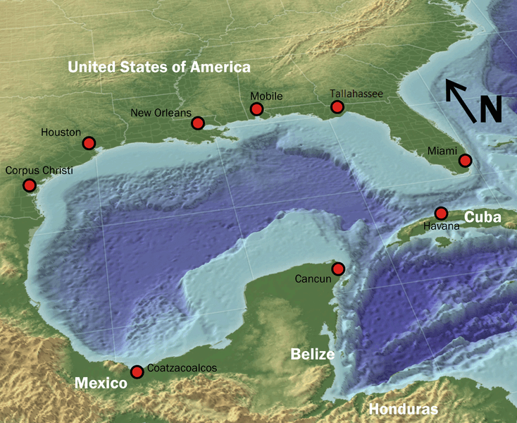
3D map of the Gulf of Mexico.
Hurricane Alley: Living with Extreme Weather
The Gulf of Mexico is one of the world's most active regions for hurricane development, with storms forming in its waters posing immediate threats to coastal communities throughout the basin. Gulf coasts in both Mexico and Cuba experience some of the most intense hurricanes in the Atlantic basin, with storms often rapidly intensifying as they move across the Gulf's warm waters before making landfall.
Hurricane Camille in 1969, Hurricane Gilbert in 1988, and Hurricane Wilma in 2005 represent some of the most devastating storms to impact the Mexican Gulf coast, each causing billions of dollars in damage and claiming hundreds of lives. Cuba's Guanahacabibes Peninsula, exposed directly to the open Gulf, was severely affected by Hurricane Ivan in 2004 and again by Wilma the following year, storms that reshaped the peninsula's coastline and underscored the particular vulnerability of Cuba's westernmost tip.
Climate change is intensifying hurricane risks throughout the Gulf region through multiple mechanisms. Rising sea surface temperatures provide more energy for storm development and intensification, while higher sea levels exacerbate storm surge impacts. Changes in atmospheric circulation patterns may also affect storm tracks and frequency, creating new patterns of risk that coastal communities throughout the region must adapt to. Communities across the Gulf have developed sophisticated traditional knowledge systems for predicting and responding to hurricanes, drawing on generations of observation of animal behavior, atmospheric conditions, and ocean characteristics that complement modern meteorological forecasting.
Conservation Challenges and Opportunities
Protecting the Gulf of Mexico's marine ecosystems requires addressing multiple interconnected threats while balancing conservation goals with economic development needs. Mexican and Cuban waters alike face particular challenges from coastal development, offshore energy activity, and pressures from tourism and fisheries, even as the two countries' approaches to Gulf development have diverged sharply, with Mexico's coast far more industrialized and Cuba's far more intact.
Marine protected areas represent one of the most important conservation tools available for protecting the Gulf ecosystem. Mexico has established several significant protected areas in Gulf waters, including the Veracruz Reef System National Park and the Flower Garden Banks National Marine Sanctuary, shared with the United States, while Cuba's Guanahacabibes Peninsula National Park and Biosphere Reserve protect one of the most ecologically intact stretches of coastline anywhere on the Gulf. Even so, the coverage and effectiveness of protected areas across the basin require substantial expansion to address the scale of conservation challenges facing Gulf ecosystems.
The Healthy Reefs for Healthy People Initiative, a collaborative effort involving Mexico, Belize, Guatemala, and Honduras, works to protect and restore the Mesoamerican Reef System through coordinated conservation actions, scientific research, and sustainable development programs. This regional approach recognizes that coral reef conservation requires addressing threats that transcend national boundaries, including climate change, pollution, and unsustainable fishing practices. In Mexico, fisheries management involves complex interactions between federal agencies, state governments, fishing cooperatives, and individual fishermen, with the Mexican National Fisheries Institute (INAPESCA) conducting scientific research to support sustainable harvest strategies developed in close cooperation with fishing communities.
Future Horizons: Sustainable Development in the Gulf
The future of the Gulf of Mexico's Latin American coastlines will be shaped by the decisions made today regarding energy development, environmental protection, and the sustainable use of marine resources. Mexico's energy sector transformation, driven by constitutional reform and changing global energy markets, creates both opportunities and challenges for Gulf environmental stewardship, while Cuba's more limited development offers a different kind of opportunity, preserving ecological intactness even amid economic pressure to further develop its own offshore resources.
Renewable energy development, particularly offshore wind power, represents a potential new chapter in the region's relationship with Gulf resources. The Gulf's shallow waters and consistent wind patterns make it a potentially suitable location for offshore wind farms, which could provide clean energy for coastal communities while reducing dependence on fossil fuels, though such developments must be carefully planned to avoid impacts on marine ecosystems and fishing activities.
Climate adaptation strategies for Gulf communities require comprehensive approaches that address sea-level rise, increasing storm intensity, and changing precipitation patterns. Nature-based solutions, including mangrove restoration, coral reef protection, and coastal wetland conservation, can provide cost-effective protection from storm surge and sea-level rise while supporting marine biodiversity and fisheries productivity. The concept of a growing blue economy offers a framework for the sustainable development of Gulf marine resources, emphasizing sustainable fisheries, marine biotechnology, coastal tourism, and marine renewable energy as alternatives to extractive industries, providing economic benefits while maintaining the ecosystem health that both Mexico's working coastline and Cuba's protected one depend upon in their own ways.
Conclusion: A Sea Shared Across Latin America
The Gulf of Mexico represents one of Latin America's most valuable shared natural assets, providing energy resources, fisheries productivity, hurricane protection, and cultural identity that have shaped Mexico and Cuba's development for centuries. This semi-enclosed sea connects both nations to global markets while supporting ecosystems of extraordinary diversity and beauty, from the industrialized, oil-rich waters of the Bay of Campeche to the quiet, karst-riddled coastline of Guanahacabibes.
The Gulf's future depends on the ability of Mexico, Cuba, and the wider region to balance competing demands for marine resources while addressing environmental challenges that respect no maritime border. Climate change, pollution, overfishing, and habitat degradation threaten the ecological integrity that both human communities and marine life depend on throughout the basin. Success in protecting and sustainably managing the Gulf's Latin American coastlines will require approaches that integrate traditional knowledge with scientific understanding, coordinate action across political boundaries, and engage coastal communities as partners in conservation. The warm waters that have supported civilizations on both shores of the Yucatán Channel for centuries must continue to provide life and prosperity for future generations, connecting Mexico's proud maritime past with Cuba's quieter one, and both nations' futures, across a single shared sea.