Costa Rica: Natural Landscape
Costa Rica is located in southern Central America, bordered by Nicaragua in the north and Panama in the southeast. The Caribbean Sea and the Pacific Ocean form its eastern and southwestern coastlines. Its geography features coastal plains and rainforests separated by rugged mountains and volcanoes.

 https://www.flickr.com/photos/31267353@N03/51097428764")

 https://www.flickr.com/photos/hbarrison/4103217926")
 https://www.flickr.com/photos/vilseskogen/5533395849")

, CC BY-SA 4.0, via Wikimedia Commons")
 https://www.flickr.com/photos/43423301@N07/14029337260")
]")

 https://www.flickr.com/photos/hectorlo/24836520450")
The Natural Landscape of Costa Rica
In the heart of southern Central America, Costa Rica boasts a captivating geography bordering Nicaragua to the north and Panama to the southeast. Its eastern coastline stretches approximately 300 kilometers (185 miles) along the vibrant Caribbean Sea, while its southwestern coastline embraces the vast expanse of the Pacific Ocean, extending for about 1,000 kilometers (620 miles). This unique positioning grants Costa Rica a remarkable diversity of landscapes, from the lush rainforests of the Caribbean coast to the rugged volcanic peaks that rise towards the Pacific.
Costa Rica's maritime territory extends beyond its mainland, encompassing an archipelago of approximately 79 islands, each with a distinct character. Among these gems is the nearly uninhabited Cocos Island, a remote paradise. At the same time, Isla Calero, with its approximately 3,000 inhabitants, offers a vibrant blend of island life and cultural heritage.
Traversing Costa Rica from north to south, the Pan-American Highway, also known as the Inter-American Highway, is a vital transportation artery. Divided into two segments, Carretera Interamericana Norte (Route 1) and Carretera Interamericana Sur (Route 2), the highway winds its way through the country's diverse landscapes, offering stunning vistas and access to its many attractions. Along its route, the highway ascends to its highest point, Cerro de la Muerte (Death Hill), at 3,335 meters (10,942 feet), providing a breathtaking panorama of the surrounding terrain.
Biodiversity
Despite its modest geographical footprint, Costa Rica stands as a global giant in terms of biodiversity, earning acclaim as one of the planet's most biodiverse nations. The country's diminutive size belies its ecological significance, as its varied landscapes, ranging from tropical rainforests and cloud forests to coastal regions and lofty mountain ranges, converge to foster an unparalleled wealth of natural heritage.
While Costa Rica ranks modestly 129th in the world by size, it skyrockets to 23rd in terms of biodiversity, a testament to its extraordinary ecological richness. The Global Biodiversity Index reveals the astounding numbers behind this distinction, with approximately 843 bird species, 212 amphibian species, 1,124 fish species, 240 mammal species, 262 reptile species, and a staggering 11,000 vascular plant species finding sanctuary within its borders.
This juxtaposition of size and biodiversity underscores Costa Rica's remarkable role as a biodiversity hotspot, where many species thrive in diverse ecosystems. The juxtaposition also highlights the country's commitment to conservation and sustainable practices, showcasing how a relatively small nation can greatly influence global biodiversity preservation. Costa Rica's natural tapestry, woven with the threads of myriad life forms, stands as a testament to the imperative of safeguarding our planet's ecological treasures.
Conservation
Costa Rica is globally recognized for its remarkable conservation success and is committed to protecting its rich biodiversity and natural resources. The country serves as a model for sustainable development and ecotourism, with conservation efforts instrumental in preserving its natural heritage.
The National System of Conservation Areas (SINAC) is central to Costa Rica's conservation success. It oversees protected zones, including national parks and wildlife reserves. SINAC plays a pivotal role in managing and preserving the country's diverse landscapes, showcasing the compatibility of economic growth with environmental protection.
Despite these achievements, challenges persist, including habitat fragmentation, illegal logging, and the need for ongoing vigilance against unsustainable development practices. The delicate balance between progress and preservation requires collaborative efforts from government agencies, local communities, and environmental organizations, with SINAC at the forefront of these initiatives.
Costa Rica's continued success in conservation stands as a testament to the positive outcomes achievable through collective dedication to environmental protection. By proactively addressing challenges and leveraging the expertise of institutions like SINAC, the country exemplifies harmonious coexistence between humanity and nature.
Climate
Costa Rica boasts a tropical and subtropical climate, featuring diverse microclimates influenced by elevation, rainfall, topography, and regional geography.
The country experiences two distinct seasons: the wet season, which lasts from May to November, and the dry season, which lasts from December to April. Notably, climate nuances emerge across regions, with the Caribbean coast characterized by higher humidity and more substantial rainfall compared to the drier Pacific coast.
The average temperature in Costa Rica hovers around 25 °C (77 °F), yet this can fluctuate depending on altitude. The lowlands tend to be warmer and more humid, while the highlands offer cooler and drier conditions, contributing to the country's climatic diversity.
Here's a refined description of the climate in different regions of Costa Rica:
- Caribbean Coast: The Caribbean coast boasts a consistently hot and humid climate, maintaining temperatures between 25 - 32 °C (77 - 90 °F) throughout the year. Notably, this region experiences an intense wet season with an annual rainfall averaging over 4,000 mm (160 in).
- Pacific Coast: Unlike the Caribbean, the Pacific Coast enjoys a more temperate climate, with temperatures ranging from 22 - 28 °C (72 - 82 °F). The wet season is less intense, marked by an annual rainfall averaging around 1,500 mm (60 in).
- Central Valley: Nestled between the Caribbean and Pacific coasts, the Central Valley features a mild climate year-round, with temperatures ranging from 18 - 25 °C (64 - 77 °F). The wet season is more temperate than the coastal regions, with yearly rainfall averaging around 1,000 mm (40 in).
- Highlands: Located in the north and south, the highlands offer a cooler climate than the lowlands. Nighttime temperatures can drop below freezing, especially during the dry season, contrasting the warmer coastal regions.
Volcanism
Costa Rica's dynamic geological landscape is marked by a notable prevalence of dormant and active volcanoes scattered across its terrain. This volcanic activity is intricately linked to the country's location along the Pacific Ring of Fire, an expansive horseshoe-shaped zone renowned for its heightened seismic and volcanic activity.
Positioned on the Caribbean Plate, Costa Rica shares its borders with the Cocos Plate in the Pacific Ocean, a plate being subducted beneath it. This subduction process is instrumental in shaping the volcanic features that define Costa Rica's topography. The subduction of the Cocos Plate beneath the Caribbean Plate creates intense geological activity, giving rise to the formation of the country's volcanoes, which collectively constitute the Central America Volcanic Arc.
The Central America Volcanic Arc is a chain of volcanoes extending from Guatemala to Panama, with Costa Rica nestled in the heart of this volcanic belt. The subduction-driven volcanic activity manifests in various forms, ranging from majestic stratovolcanoes to volcanic fields, each contributing to the country's captivating and diverse landscape.
This geological phenomenon not only shapes Costa Rica's physical characteristics but also plays a crucial role in the country's ecosystem and biodiversity. Volcanic soils, enriched with minerals and nutrients, contribute to the fertility of the surrounding areas, fostering lush vegetation and supporting diverse flora and fauna. While some volcanoes remain dormant, others exhibit intermittent activity, attracting scientific interest and awe from visitors who marvel at the powerful forces shaping the country's natural wonders.
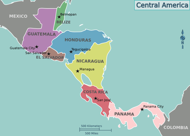
Location map of the countries of Central America.
Natural Geography of Costa Rica
Relief
Costa Rica's mountain ranges include two chains that run almost the entire length of the country: the Cordillera Volcánica in the north and the Cordillera de Talamanca in the south.
The Cordillera Volcánica in the north can be divided into three ranges from northwest to southeast: Cordillera de Guanacaste, Cordillera de Tilarán, and Cordillera Central.
The Costa Rican Central Valley (Valle Central) lies between the Cordillera Central in the north and the Cordillera de Talamanca in the south. The Continental Divide divides the valley into two parts. The eastern part drains into the Caribbean Sea, and the western part empties into the Pacific Ocean.
In the south of Costa Rica, another large valley, the Valle del General, lies southwest of the base of the Cordillera de Talamanca. Costa Rica's lowland plains can be divided into three groups: the northern plains, the Caribbean plains, and the Pacific plains.
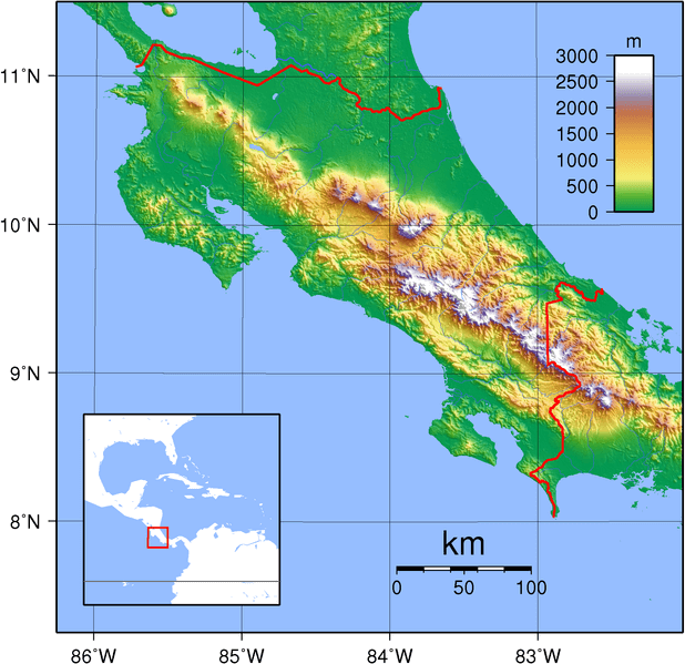
Topographic map of Costa Rica.
Geographic Regions
Costa Rica can be divided into six main geographic regions, each offering unique landscapes and ecosystems:
Central Valley (Valle Central): The Central Valley is Costa Rica's political, economic, and cultural hub. Surrounded by volcanic mountain ranges, including the Poás and Irazú volcanoes, the valley features fertile plains that support agriculture. San José, the capital city, offers a mix of modern and historical attractions. Visitors can explore museums, theaters, and markets and enjoy the valley's pleasant climate.
Pacific Northwest (Guanacaste): Guanacaste is characterized by a dry tropical climate, making it the driest region in the country. The landscape includes savannas, dry forests, and volcanic mountain ranges such as Rincon de la Vieja. The beaches along the Pacific coast, including Tamarindo and Playas del Coco, are renowned for their golden sands and excellent surfing conditions. Guanacaste also features hot springs, waterfalls, and diverse wildlife.
Central Pacific (Pacífico Central): The Central Pacific region is known for its stunning beaches, tropical rainforests, and vibrant marine life. Manuel Antonio National Park is a popular destination, offering white-faced capuchin monkeys, sloths, and beautiful beaches. The town of Jacó is a hotspot for surfing, while the Marino Ballena National Park features a distinctive whale's tail-shaped sandbar.
Atlantic Central (Caribe Central): The Atlantic Central region has lush rainforests, intricate canal systems, and a laid-back Caribbean atmosphere. Tortuguero National Park is a highlight, known for its sea turtle nesting sites and diverse wildlife, including monkeys and birds. The town of Puerto Limón is a major port with a solid Afro-Caribbean influence, reflected in its culture, music, and festivals. La Amistad International Park spans both this region and the South Pacific region. It is a transboundary protected area that extends into Panama as well.
South Pacific (Zona Sur): The South Pacific region is a remote and less-visited area known for its untouched rainforests, rugged mountains, and pristine beaches. Corcovado National Park, part of the Osa Peninsula, is a biodiversity hotspot with abundant wildlife, including jaguars and scarlet macaws. Along with the Atlantic Central region, this region hosts the La Amistad International Park, a Transboundary Protected Area extending along the border between Costa Rica and Panama. Located within the Cordillera de Talamanca, the park contains one of Central America's significant remaining blocks of natural forest.
Northern Lowlands (Llanuras del Norte): The Northern Lowlands feature expansive plains, wetlands, and tropical rainforests. This region is part of the more extensive lowland rainforest that extends into Nicaragua. The Cano Negro Wildlife Refuge is a significant area for birdwatching, with herons, kingfishers, and other waterfowl. The Northern Lowlands offer a quieter and off-the-beaten-path experience compared to some of the more popular tourist destinations in Costa Rica. The iconic Arenal Volcano is located in the northwestern part of the region.
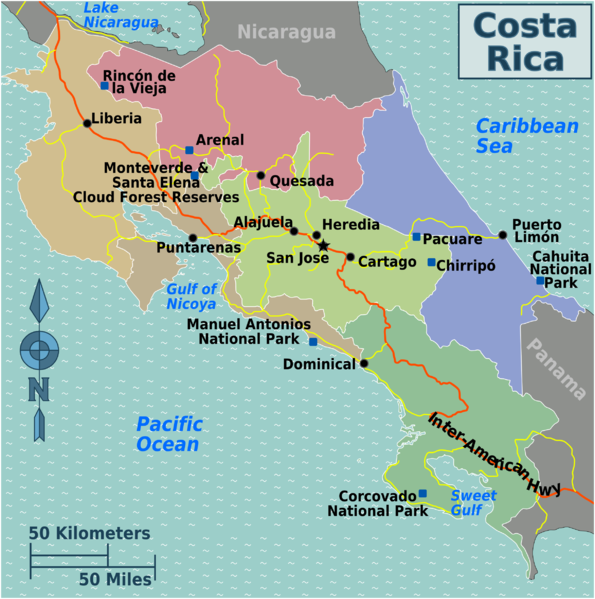
Map depicting the geographic regions of Costa Rica.
Mountain Ranges
Nestled in the heart of Central America, Costa Rica boasts an array of diverse mountainous regions spanning its northern border to its southern shores.
See more: Mountain Ranges of Costa Rica
Islands and Archipelagos
Costa Rica has several islands and archipelagos off its Pacific and Caribbean coasts. These islands and archipelagos offer a range of experiences, from biodiverse conservation areas to opportunities for cultural immersion and outdoor activities. The country has a long coastline and diverse geography, home to various islands, each with unique charm and attractions. While some are popular tourist destinations, others remain relatively untouched and provide unique insights into Costa Rica's natural and cultural heritage.
See more: Islands and Archipelagos of Costa Rica
Bodies of Water
Costa Rica's water bodies include many lakes, lagoons, rivers, and waterfalls. Most rivers that crisscross the country originate in the central volcanic mountains. Gulfs and bays pocket the coasts, while lakes and lagoons dot the countryside and fill mountaintop craters.
See more: Water Bodies of Costa Rica
Administrative Divisions
Costa Rica is constitutionally divided into seven provinces, further divided into 82 cantons and 473 districts.
See more: Cultural Landscape of Costa Rica
Natural Regions
Approximately one-third of Costa Rica's landscape is covered by dense, broad-leaved evergreen forest. These forests include mahogany and tropical cedar trees. Numerous evergreen oaks grow on the slopes of the southern Talamanca range. Much of the northwest contains open deciduous forests, while palm trees are standard on the Caribbean coastline. Mangroves grow on the protected shores of the Pacific Gulfs. In addition, mosses, orchids, and tropical plants are abundant.
Ecological Regions of Costa Rica
The following is a list of terrestrial ecoregions in Costa Rica defined by the World Wide Fund for Nature (WWF). Costa Rica is in the Neotropical realm. Ecoregions are classified by biome type - the major global plant communities determined by rainfall and climate.
Montane grasslands and shrublands
Tropical and subtropical moist broadleaf forests
Central American Atlantic moist forests
Cocos Island moist forests
Costa Rican seasonal moist forests
Isthmian-Atlantic moist forests
Tropical and subtropical dry broadleaf forests
Mangroves
Bocas del Toro-San Bastimentos Island-San Blas mangroves
Moist Pacific Coast mangroves
Rio Negro - Rio San Sun mangroves
Southern Dry Pacific Coast mangroves
Mosquitia-Nicaraguan Caribbean Coast mangroves
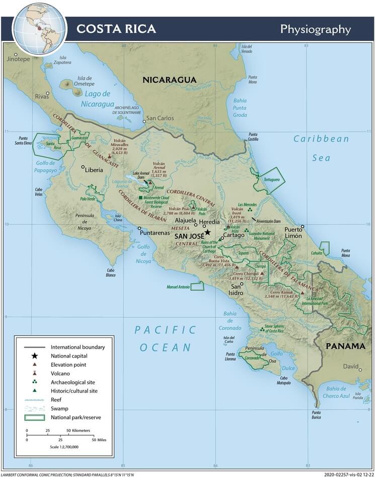
Costa Rica physiographic map.