Golfo Dulce, Osa Peninsula, and Coronado Bay: A Haven of Biodiversity in Costa Rica
The southern Pacific coast of Costa Rica is home to some of the most ecologically rich and visually stunning landscapes in Central America. The Golfo Dulce, the Osa Peninsula, and Coronado Bay stand out as a triad of natural wonders, each contributing to the region's environmental significance.
, in southern Costa Rica - via Wikimedia Commons")


 https://www.flickr.com/photos/8063840@N02/2409195284")
 https://www.flickr.com/photos/8063840@N02/2408361593")
 https://www.flickr.com/photos/miguelvieira/5538544681/")

Golfo Dulce, Osa Peninsula, and Coronado Bay: Guardians of Costa Rica's Natural Heritage
The southern Pacific coast of Costa Rica is home to some of the most ecologically rich and visually stunning landscapes in Central America. Among these, the Golfo Dulce, the Osa Peninsula, and Coronado Bay stand out as a triad of natural wonders, each contributing uniquely to the region's biodiversity and environmental significance. The following exploration delves into these areas' geographical, ecological, and cultural importance, offering an in-depth examination of their distinct ecosystems, conservation efforts, and role in Costa Rica's broader environmental narrative.
Geographical Overview
Golfo Dulce ("Sweet Gulf") is an extraordinary tropical fjord located in the southern Puntarenas province of Costa Rica, nestled between the Osa Peninsula to the west and the mainland to the east. It is one of the world's only tropical fjords, measuring approximately 24 kilometers (15 miles) in breadth, characterized by its deep waters and unique ecological conditions. The fjord-like structure is due to the steep drop-off from the coastline, with depths plunging to nearly 215 meters (705 feet). This creates a distinct marine environment that supports diverse marine life.
The Osa Peninsula juts out into the Pacific Ocean, forming the western boundary of Golfo Dulce. The peninsula, covering an area of about 2,400 square kilometers (930 square miles), is one of the most significant biological regions in the world. It is home to Corcovado National Park, a vast expanse of virgin rainforest containing some of the planet's highest biodiversity. The peninsula's rugged terrain, with its mix of lowland rainforest, mangroves, and coastal ecosystems, is a living laboratory of evolution and natural history.
Coronado Bay, another important coastal feature of the Puntarenas province, lies north of the Osa Peninsula. The bay, extending approximately 40 kilometers (25 miles) from northeast to southwest, is bordered by the expansive Térraba-Sierpe National Wetlands, a vast delta formed by the Térraba River, the most extensive river system in Costa Rica. The bay and its surrounding wetlands are crucial for the health of the region's marine and terrestrial ecosystems, acting as a buffer zone that filters nutrients and sediments before they reach the open ocean.
Ecological Significance
Golfo Dulce: A Marine Sanctuary
Golfo Dulce is a marine sanctuary of unparalleled importance. Its deep, warm waters (averaging around 29°C or 84°F) and freshwater inflow from four major rivers create a unique environment where marine species thrive. The Gulf is particularly noted for being a critical breeding ground for several species of whales, including Humpback Whales, which migrate from both the Northern and Southern Hemispheres to give birth in its protected waters. Other marine mammals, such as Spotted Dolphins and Bottlenose Dolphins, are commonly seen, while Orcas occasionally visit the Gulf, attracted by the rich feeding grounds.
The Gulf is also home to various shark species, including the Whale Shark and the Scalloped Hammerhead, as well as large fish like Marlins and Dorados. The abundance of small fish and plankton provides a vital food source for these larger predators, ensuring the health of the entire marine food web. Invertebrates such as jellyfish, Portuguese Man-O-Wars, and sea stars contribute to the biodiversity, making the Gulf a hotspot for marine life.
Sea turtles, including the Pacific Green Sea Turtle, Olive Ridley, Hawksbill, and Pacific Leatherback, are frequent visitors to the Gulf. They are drawn by the warm waters and the presence of jellyfish and marine plants, which serve as their primary food sources. These turtles face numerous threats, including habitat loss and illegal poaching, but ongoing conservation efforts in the region aim to protect these ancient mariners.
In 2018, the Costa Rican government took a significant step in marine conservation by establishing a 4,000-hectare (10,000-acre) no-take zone within the wetlands north of Golfo Dulce, specifically designed to protect the scalloped hammerhead shark. This shark sanctuary is the first in Costa Rica, highlighting the region's importance in global shark conservation efforts.
The Osa Peninsula: A Biodiversity Hotspot
The Osa Peninsula is often called the crown jewel of Costa Rica's protected areas. It is home to Corcovado National Park, which covers approximately 424 square kilometers (164 square miles) of pristine rainforest and is part of the Osa Conservation Area. This park alone is estimated to contain 2.5% of the world's biodiversity, making it one of Earth's most biologically intense places.
The peninsula's diverse habitats support a wide variety of species, including many that are rare or endangered. The rainforest is teeming with life, from the iconic jaguar (Panthera onca) to the elusive Baird's tapir (Tapirus bairdii), both of which are critical to the region's ecological balance. The park is also a sanctuary for all four species of Costa Rican monkeys: the Central American squirrel monkey, Geoffrey's spider monkey, the Mantled howler monkey, and the White-headed capuchin monkey.
Birdlife on the Osa Peninsula is equally impressive, with over 400 species recorded, including the Scarlet Macaw and the Harpy Eagle. These birds play a vital role in the ecosystem, particularly in seed dispersal and maintaining the health of the forest.
The peninsula's coastal areas and mangroves are no less important. They provide breeding grounds for marine species and act as natural buffers against storms and coastal erosion. The mangroves are also home to various bird species and serve as nurseries for many fish and invertebrates, further enhancing the region's ecological value.
Coronado Bay: A Vital Coastal Ecosystem
Coronado Bay, located north of the Osa Peninsula, is another critical ecological zone. The Térraba River, Costa Rica's largest river, feeds the bay, which forms an extensive delta before emptying into the Pacific Ocean. The Térraba-Sierpe National Wetlands, which surround the bay, are among Central America's most important wetland ecosystems, providing habitat for a wide range of species.
The wetlands are home to numerous bird species, including the Roseate Spoonbill and the Mangrove Hummingbird, both of which rely on the unique conditions of the mangroves for survival. The delta is also a critical area for fish breeding and supports a variety of invertebrates, making it an essential component of the region's marine ecosystem.
The presence of offshore islands, such as Isla del Caño, adds to the region's ecological diversity. These islands are important breeding sites for seabirds and serve as stepping stones for migratory species. The surrounding waters are rich in marine life, including dolphins, sea turtles, and numerous fish species, making Coronado Bay a key area for biodiversity and eco-tourism.
Conservation Efforts and Challenges
The Golfo Dulce, Osa Peninsula, and Coronado Bay regions are at the forefront of Costa Rica's conservation efforts. The establishment of numerous protected areas, including Corcovado National Park and the Térraba-Sierpe National Wetlands, reflects the country's commitment to preserving its natural heritage. However, these areas face significant challenges, particularly from human activities such as deforestation, illegal poaching, and unsustainable fishing practices.
The rapid expansion of agriculture and tourism has also put pressure on these ecosystems, leading to habitat loss and fragmentation. Conservation organizations and local communities are working together to promote sustainable practices that balance environmental protection with economic development.
Community-based conservation initiatives, such as those led by Indigenous groups and local fishermen, are crucial in preserving the region's biodiversity. These initiatives often focus on protecting critical habitats, restoring degraded areas, and promoting eco-tourism as a sustainable alternative to more destructive activities.
One of the region's most significant challenges is the impact of climate change. Rising sea levels, increasing temperatures, and changing precipitation patterns all affect these ecosystems' delicate balance. Conservation efforts must adapt to these changing conditions to ensure the long-term survival of the species and habitats that depend on them.
Cultural and Economic Importance
Beyond their ecological value, the Golfo Dulce, Osa Peninsula, and Coronado Bay regions are also culturally and economically significant. The indigenous communities that have lived in these areas for centuries have a deep connection to the land and sea, relying on natural resources for their livelihoods and cultural practices.
Eco-tourism has become an increasingly important economic driver in the region, attracting visitors worldwide who experience the unique biodiversity and stunning landscapes. The income generated from tourism supports local communities and provides funding for conservation efforts, creating a positive feedback loop that benefits both people and nature.
The region's natural beauty and biodiversity also make it a focal point for scientific research, attracting biologists, ecologists, and conservationists who study the complex interactions between species and their environments. This research contributes to our understanding of tropical ecosystems and informs global conservation strategies.
Conclusion
The Golfo Dulce, Osa Peninsula, and Coronado Bay regions represent some of Costa Rica's most biologically diverse and ecologically significant areas. From the deep waters of Golfo Dulce, teeming with marine life, to the dense rainforests of the Osa Peninsula and the vital wetlands of Coronado Bay, these areas are a testament to the richness of Costa Rica's natural heritage.
Conservation efforts in these regions are crucial for preserving the unique ecosystems and the countless species that inhabit them. While challenges remain, the commitment of local communities, conservation organizations, and the Costa Rican government offers hope for the future of these remarkable landscapes. As the world continues to grapple with environmental challenges, the Golfo Dulce, Osa Peninsula, and Coronado Bay stand as a shining example of what can be achieved through dedication to conservation and sustainable development.
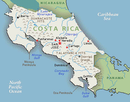
Map of Costa Rica.