Paraguay: Natural Landscape
Paraguay, situated in the south-central heart of South America, is a landlocked country but possesses a strategic advantage thanks to the Paraguay and Paraná rivers. These rivers provide crucial access to the Atlantic Ocean, enabling trade and regional connectivity that drive the nation's economy.


 and the Parana (left). At the bottom of the image is Argentina, Brazil is at the top right, and Paraguay is to the left. - by Redneck, CC BY 2.0, via Wikimedia Commons")


Paraguay's Natural Landscape: A Land of Diverse Regions and Rich Biodiversity
Paraguay, situated in the south-central heart of South America, spans 406,752 square kilometers (157,050 square miles) and is bordered by Bolivia to the north and northwest, Argentina to the south and southwest, and Brazil to the east and northeast. While a landlocked country, Paraguay possesses a strategic geographical advantage thanks to the Paraguay and Paraná rivers, which provide crucial access to the Atlantic Ocean, enabling trade and regional connectivity that drive the nation's economy. Within its borders, Paraguay reveals diverse topographies and ecosystems, ranging from fertile plains to arid lowlands, that shape its population distribution, economy, and cultural heritage.
Distinct Geographic Regions: The Paraneña and Chaco Boreal
The Paraguay River, one of South America's primary waterways, flows centrally through the nation, creating two distinct geographical regions: the Paraneña in the east and the Chaco Boreal in the west. This natural division not only defines Paraguay's landscapes but also significantly impacts its demographic and cultural dynamics.
The Paraneña Region
Occupying the eastern portion of Paraguay, the Paraneña Region is a land of fertile plains, rolling hills, and subtropical forests. This region is home to approximately 95% of the country's population, who benefit from its more hospitable climate and arable land. Known for its lush landscapes, it hosts the nation's largest cities, including the capital, Asunción, and serves as its economic and cultural hub. Agricultural activities such as soybean cultivation, cattle ranching, and cotton farming thrive here, underscoring the region's vital role in Paraguay's economy.
The Chaco Boreal Region
The Chaco Boreal, or simply "the Chaco," occupies western Paraguay and starkly contrasts the Paraneña's lush landscapes. Characterized by its semi-arid climate and expansive lowlands, the Chaco covers roughly 60% of Paraguay's land area but hosts only a small fraction of its population due to challenging living conditions. The region is known for its savannas, scrub forests, and seasonal swamps, where unique flora and fauna have adapted to the arid environment. The Chaco's wildlife, including jaguars, tapirs, and armadillos, and its sparse human population contribute to its reputation as one of South America's last frontiers.
Paraguay's Biodiversity: A Hidden Ecological Treasure
Despite its modest size, Paraguay ranks as a significant player in global biodiversity thanks to its position within the Upper Paraná Atlantic Forest, one of the world's major biodiversity hotspots. Paraguay's ecosystems host a remarkable diversity of flora and fauna, demonstrating the resilience and richness of its natural heritage. This biodiversity contributes to Paraguay's environmental health and underscores its importance in the global conservation landscape.
Flora and Fauna
The country's biodiversity reflects its varied topographies and climates. According to the Global Biodiversity Index, Paraguay is ranked 53rd in biodiversity worldwide. The country is home to 690 bird species, 80 amphibian species, 266 fish species, 181 mammal species, 189 reptile species, and an astonishing 7,851 vascular plant species. This remarkable variety is evident in regions such as the Mbaracayú Forest Nature Reserve, a UNESCO Biosphere Reserve where endemic and endangered species thrive. Meanwhile, in the Chaco Boreal, species such as the endangered Chacoan peccary (a unique pig-like mammal native to the region) showcase its distinctive wildlife and adaptability to Paraguay's more arid climates.
Conservation Efforts: Balancing Biodiversity and Development
Paraguay has embraced conservation as a national priority, with efforts to protect its ecosystems gaining momentum in recent years. Recognizing the value of its unique biodiversity, the country has designated numerous protected areas, including national parks and biosphere reserves. Noteworthy among these are the Defensores del Chaco National Park, the Mbaracayú Biosphere Reserve, and the Ñeembucú Wetland Biosphere Reserve, which serve as safe havens for threatened species and ecosystems.
Conservation Challenges
Despite these initiatives, Paraguay faces significant challenges in safeguarding its ecosystems. Deforestation for agriculture, particularly in the eastern Paraneña region, has led to substantial habitat loss, while unsustainable agricultural practices and the illegal wildlife trade further threaten biodiversity. The Paraguayan government and various NGOs are working to mitigate these issues through programs that promote sustainable farming and forest conservation and through education and community involvement to foster a sense of environmental stewardship among local populations.
Climate: Subtropical Variability Across Regions
Paraguay experiences a subtropical climate with notable regional variations shaped by its geography and position within the continent. The country's climate generally falls into two primary categories: the humid climate of the Eastern Region and the more arid conditions in the Western Chaco Region.
Eastern Region Climate
The Eastern Region, where most Paraguayans reside, experiences a humid subtropical climate, with temperatures generally ranging from 20 to 24 °C (68 to 75 °F). This area's rainy season extends from October to March, with December and January receiving the highest rainfall. The abundance of precipitation and mild climate create favorable conditions for agriculture, supporting Paraguay's primary agricultural exports, including soybeans and corn.
Western Region Climate: The Chaco
The Chaco's climate is characterized by high temperatures and low precipitation, with average temperatures ranging from 25 to 29 °C (77 to 84 °F). While the rainy season is short, lasting from November to February, the Chaco is otherwise semi-arid, with sporadic rainfall patterns. The challenging climate of the Chaco limits agriculture, but hardy cattle ranching operations have thrived here, adapting to the arid environment and contributing to Paraguay's economy.
Seasonal Rainfall Patterns and Regional Variability
On average, Paraguay receives 1,500 mm (59 inches) of rainfall annually, though distribution varies significantly between the Eastern and Western regions. The Eastern Region receives more consistent and abundant rainfall, while the Western Region receives less, supporting its characteristic dry landscapes. Additionally, a north-to-south gradient affects rainfall, with the northern areas generally wetter than those to the south. This distribution reflects Paraguay's complex climate system, shaping its landscapes, agricultural practices, and settlement patterns.
Paraguay's Rivers: The Lifelines of the Nation
Paraguay's landlocked position is offset by its river systems, essential to its economy, ecosystem health, and way of life. The Paraguay and Paraná Rivers are the country's most important waterways, supporting transportation, trade, and agriculture.
Paraguay River
The Paraguay River, which flows over 2,600 kilometers (1,616 miles) from its source in Brazil to its confluence with the Paraná River, bisects the nation and is a critical transportation artery. The river's strategic importance cannot be overstated: it facilitates trade, provides agricultural irrigation, and sustains various fish species that local communities depend on.
Paraná River
The Paraná River, which runs along Paraguay's southeastern border, is a crucial element of the nation's hydroelectric infrastructure. The Itaipú Dam, a massive hydroelectric project shared with Brazil, generates substantial electricity and is one of the world's largest dams. Alongside the Yacyretá Dam, Paraguay's renewable energy resources provide for its own energy needs and supply surplus electricity to neighboring countries, solidifying the river's role in the national economy and environmental sustainability.
Conclusion
Paraguay's natural landscape is defined by its distinct geographical regions, rich biodiversity, and dynamic climate patterns. The division of the Paraneña and Chaco Boreal regions illustrates the country's varied terrain, while its biodiversity highlights Paraguay's significance in global conservation efforts. The nation's rivers, though landlocked, provide vital trade routes and foster agricultural productivity, positioning Paraguay as a resilient and adaptive nation in the heart of South America. Despite challenges, Paraguay's ongoing commitment to conservation underscores its dedication to preserving its natural heritage, ensuring that future generations can experience the ecological richness that defines this landlocked yet vibrant country.
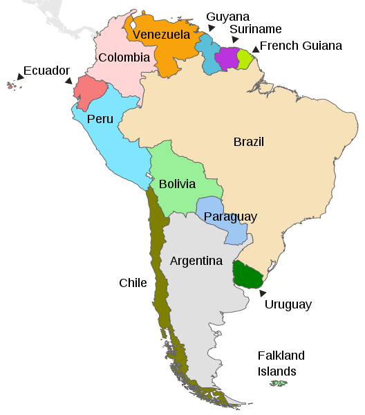
Map depicting the countries on the continent of South America.
Natural Geography of Paraguay
Geographic Regions
The Paraguay River divides the country into two distinct eastern and western geographic regions:
Eastern Region (Región Oriental): also known as the Paraneña, composed chiefly of grassy plains and wooded hills
Western Region (Región Occidental): also known as the Chaco Boreal, composed mainly of low, marshy plains
Eastern Region (Región Oriental)
The Eastern Region, also known as the Paraneña, extends from the Paraguay River eastward to the Paraná River, forming the country's border with Brazil and Argentina. Approximately 95% of the country's population resides in the Paraneña region, covering roughly 160,000 sq km (61,700 sq mi). An extension of the Brazilian Plateau, the region is dominated by a fertile, cultivated landscape that features rolling hills, low mountains, and subtropical forests.
The Eastern region can be divided into five physiographic subregions:
Paraná Plateau: occupies one-third of the area and extends its entire length from north to south, approximately 145 km (90 mi) westward from the Brazilian and Argentine borders
Northern Upland: consists of a rolling plateau about 180 m (590 ft) above sea level
Central Hill Belt: encompasses the area in the vicinity of Asunción and consists of uneven rolling terrain with numerous small isolated peaks and a few lakes
Central Lowland: an area of low elevation and relief, sloping gently upward from the Paraguay River toward the Paraná Plateau
Ñeembucú Plain: an alluvial plain consisting of a swampy lowland bisected by the Tebicuary River, a major tributary of the Paraguay River
Western Region (Región Occidental)
The Western Region is also known as the Chaco or Chaco Boreal, part of the Gran Chaco. The Chaco's hot scrublands and low plains cover about 60% of Paraguay's land area. It is one of the most sparsely populated regions in South America. Separated from the Eastern region by the Paraguay River, the Chaco region is a vast plain with elevations reaching no higher than 300 m (980 ft) and averaging 125 m (400 ft).
The Paraguayan Chaco is subdivided into two parts:
Upper Chaco or Dry Chaco makes up the western three-quarters of the Chaco region, bordering Bolivia
Lower Chaco or Humid Chaco borders the Paraguay River in the east
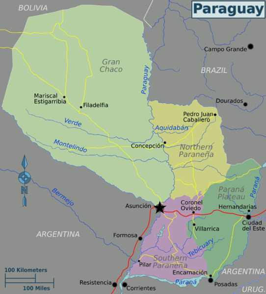
Map depicting the geographic areas of Paraguay.
Bodies of Water
Paraguay is a landlocked country in South America. While it does not have direct access to the sea, it is home to several significant water bodies, including rivers, lakes, lagoons, dams, and reservoirs. These play a critical role in the country's water resources, economy, and natural environment.
See more: Water Bodies of Paraguay
Administrative Divisions
Paraguay is divided into two regions, seventeen departments, and one capital district for administrative purposes. Each department is subdivided into districts and has a capital city.
See more: Cultural Landscape of Paraguay
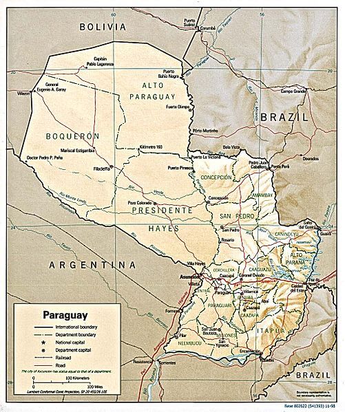
Shaded relief map of Paraguay.
Natural Regions
Ecological Regions
The following is a list of terrestrial ecoregions in Paraguay, as defined by the World Wide Fund for Nature (WWF). Paraguay is in the Neotropical realm. Ecoregions are classified by biome type - the major global plant communities determined by rainfall and climate.
Tropical and subtropical moist broadleaf forests
Alto Paraná Atlantic forests: a large block of Atlantic semi-deciduous forest
Tropical and subtropical dry broadleaf forests
Dry Chaco: comprised of several habitats, although savanna and thorn forests predominate
Tropical and subtropical grasslands, savannas, and shrublands
Humid Chaco: a mosaic of ecosystems including woodland and savanna where various species of trees, shrubs, and coarse grass develop
Cerrado: the largest savanna region in South America
Flooded grasslands and savannas
Pantanal: the largest wetland in South America
Paraná flooded savanna: the middle and lower Paraná River floodplains and its tributary, the Paraguay River, have primarily been converted to agriculture or occupied by urban development
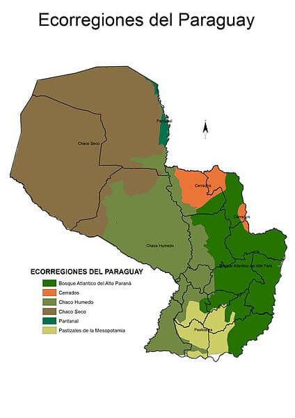
Map depicting the ecoregions of Paraguay.