The Paraguay River: Lifeline of South America
The Paraguay River, South America's fifth-largest river, is vital for the continent's southern regions. From its source in Brazil to its confluence with the Paraná River in Argentina, the river influences the livelihoods of millions, making it one of the most significant waterways on the continent.

Flowing Through the Heart of South America: The Paraguay River and Its Basin
The Paraguay River, South America's fifth-largest river, is vital for the continent's southern regions. Running approximately 2,600 kilometers (1,600 miles) from its source in Brazil to its confluence with the Paraná River in Argentina, the river flows through Brazil, Paraguay, and Argentina, shaping both landscapes and societies along its route. The river not only serves as a critical geographical feature but also demarcates national borders and influences the livelihoods of millions, making it one of the most significant waterways on the continent. Its extensive drainage basin, covering over 1,000,000 square kilometers (386,000 square miles), encompasses several ecosystems. It is crucial in maintaining biodiversity, especially in the Pantanal, one of the world's most ecologically diverse wetlands.
The Paraguay River: Geography and Course
The Paraguay River originates south of Diamantino in the Brazilian state of Mato Grosso, within the Brazilian Highlands. It flows generally north-to-south, weaving its way through Brazil, Paraguay, and Argentina. The river serves as a natural boundary, particularly between Paraguay and Brazil and between Paraguay and Argentina.
Throughout its 2,600-kilometer journey, the river divides the country of Paraguay into two distinct regions. To the west lies the semi-arid and sparsely populated Gran Chaco. At the same time, the east is characterized by fertile lands and dense forests, where the vast majority of Paraguay's population resides. The river is a lifeline for these regions, providing essential water for agriculture, drinking, and transportation. Additionally, it serves as a critical connection to the Paraná River, which it eventually meets, contributing to one of South America's most significant river systems—the Río de la Plata Basin.
The Paraguay River Basin
The Paraguay River Basin is an expansive area spanning over 1,000,000 square kilometers (386,000 square miles) and encompassing southern Brazil, Bolivia, Paraguay, and northern Argentina. It is the second most important river basin in the Río de la Plata system after the Paraná River Basin.
The basin's elevation is generally low, rarely surpassing 200 meters (650 feet), making it ideal for sustaining wetland ecosystems and fertile plains. Its influence extends across vast portions of South America, shaping agricultural practices and natural habitats. The water from the basin feeds into countless smaller tributaries that eventually merge into the Paraguay River, and this intricate network provides critical water resources for both human use and wildlife habitats. Furthermore, the basin supports large-scale agriculture and fishing communities that rely on its abundance of freshwater species.
The Pantanal: A Natural Marvel within the Basin
One of the most biologically rich environments on the planet, the Pantanal, is located within the upper Paraguay River Basin. This region represents the most significant tropical wetland in the world, sprawling across parts of Brazil, Bolivia, and Paraguay. Covering an area of approximately 140,000 square kilometers (54,000 square miles), the Pantanal plays a crucial role in regulating the water flow of the Paraguay River.
The Pantanal experiences seasonal flooding, with torrential rains filling its expansive basin and creating vast wetlands that temporarily submerge the landscape. As the waters recede, they leave smaller pools filled with fish and other aquatic life, attracting diverse bird species, including egrets, storks, and spoonbills. This annual cycle of flooding and draining makes the Pantanal a dynamic habitat for countless species of plants and animals, contributing to its status as one of South America's most important ecological zones.
The Pantanal is a haven for wildlife and a vital resource for local communities. The floodwaters enrich the soil, supporting agriculture and cattle ranching while supplying freshwater to surrounding populations. Additionally, it provides a thriving eco-tourism industry, with visitors drawn to its unique landscapes and biodiversity.
Ecological Significance and Environmental Challenges
The Paraguay River and its basin are integral to maintaining ecological balance in the region. They support many species, from aquatic life in the river to the diverse wildlife inhabiting the Pantanal wetlands. This region's biodiversity is considered globally significant, with the Pantanal home to numerous endemic species, including the jaguar, giant otter, and the endangered marsh deer.
However, the river and its basin face increasing environmental challenges. Agricultural expansion, deforestation, and infrastructure projects, such as dams and water diversion efforts, threaten the natural flow of the river and the delicate ecosystems it supports. Deforestation in the Brazilian Highlands, where much of the basin's water originates, has resulted in soil erosion, increasing sedimentation in the river and its tributaries. In addition, climate change poses a significant risk, with rising temperatures and shifting precipitation patterns potentially altering the annual flood cycles that sustain the Pantanal.
Efforts to preserve and protect the Paraguay River Basin are underway, with initiatives aimed at sustainable land use, conservation of wetlands, and protection of biodiversity. These measures are essential for preserving the natural environment and supporting the livelihoods of millions of people who depend on the river and its resources.
Conclusion
The Paraguay River, with its vast basin and vital ecosystems, plays a crucial role in shaping South America's geography, economy, and biodiversity. As the lifeblood of Paraguay and a key component of the larger Río de la Plata Basin, the river supports millions of people and countless species that thrive within its waters and surrounding lands. While the river's ecological significance is undeniable, it faces growing environmental pressures, underscoring the need for sustainable management and conservation efforts to protect this invaluable resource for future generations. The river remains a symbol of natural and cultural connectivity across the heart of South America, flowing through nations and providing life to its inhabitants and wildlife alike.
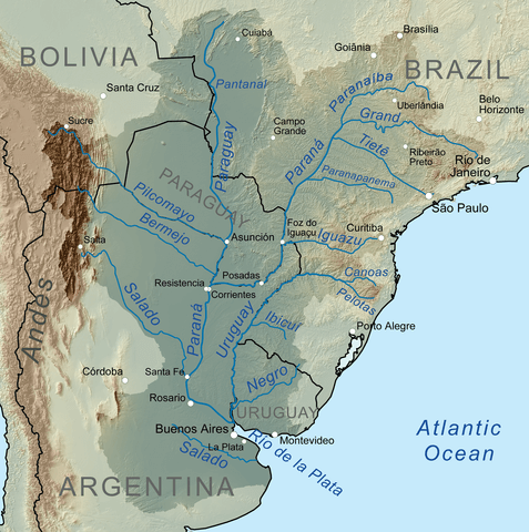
The map depicting the Río de la Plata Basin shows the Paraguay River joining the Paraná River.