Brazil: Natural Landscape
Brazil is the largest country in the region and the fifth largest globally. Known for its geographical diversity, Brazil boasts ecosystems that range from rainforests and grasslands to mountains and savannas, contributing to its renowned natural beauty and status as a global leader in biodiversity.
 https://www.flickr.com/photos/39997856@N03/5791936250")
 https://www.flickr.com/photos/55953988@N00/16296062250")

 (CC BY-NC-SA 3.0)")
 https://www.flickr.com/photos/bombeador/51084762637")


 https://www.flickr.com/photos/11962592@N00/395626323")
The Natural Landscape of Brazil: A Tapestry of Diversity and Richness
Occupying nearly half of the South American continent, Brazil is the largest country in the region and the fifth largest globally. Known for its geographical diversity, Brazil boasts ecosystems that range from rainforests and grasslands to mountains and savannas, contributing to its renowned natural beauty and status as a global leader in biodiversity. Bordered by the Atlantic Ocean along its 7,491 km (4,655 mi) coastline, Brazil shares land borders with nearly every South American country, emphasizing its vast reach across the continent. This geographical expanse and strategic location result in a natural landscape as varied as it is breathtaking.
Geographic Regions of Brazil
Brazil is administratively divided into 26 states and the Federal District, with regions traditionally grouped into five geographic zones: North, Northeast, Central-West, Southeast, and South. These divisions reflect Brazil's distinct landforms and ecosystems, each hosting unique biomes that contribute to the country's rich ecological tapestry.
Biodiversity
Brazil's Megadiverse Ecosystems
As the most biodiverse country on Earth, Brazil has more species than any other, containing 20% of the world's known animal and plant life. Its six terrestrial biomes—the Amazon, Cerrado, Pantanal, Atlantic Forest, Caatinga, and Pampas—create a dynamic landscape where thousands of unique species thrive.
Brazil's biological wealth includes over 1,800 bird species, more than 1,100 amphibian species, nearly 4,750 fish species, around 700 mammal species, and over 34,000 vascular plant species, underscoring its place among the 17 megadiverse countries that collectively harbor most of the Earth's biodiversity. This species richness makes Brazil a central player in global conservation efforts, as many species are found nowhere else on the planet.
The Amazon Rainforest: The World's Largest Tropical Rainforest
The Amazon Rainforest, spanning nearly 5.5 million sq. km (2.1 million sq. mi), covers 40% of Brazil's landmass and is the most iconic of Brazil's biomes. Known as the "lungs of the Earth," the Amazon is critical in regulating the global climate by absorbing carbon dioxide and releasing oxygen. This biome is home to an astonishing diversity of life, including jaguars, sloths, river dolphins, and countless plant species. However, deforestation and agricultural expansion threaten this critical ecosystem, sparking global efforts to preserve it.
The Pantanal: The World's Largest Tropical Wetland
Located in the Central-West, the Pantanal spans about 210,000 sq. km (81,000 sq. mi) and is the largest tropical wetland on Earth. Known for its high concentration of wildlife, the Pantanal is a haven for species like the jaguar, capybara, and giant otter. Its seasonal flooding cycle nurtures a unique ecosystem with rich biodiversity, including aquatic plants and diverse bird species. Conservation efforts in the Pantanal are crucial as climate change and human encroachment increasingly threaten its delicate ecosystem.
Conservation Efforts and Challenges
Conservation Importance
Brazil's natural resources, including vast rainforests, rivers, wetlands, and diverse wildlife, make conservation efforts in the country critically important. While Brazilian landscapes support unparalleled biodiversity, they face significant challenges from deforestation, illegal mining, land use changes, and economic pressures.
The Amazon, for instance, has seen vast portions cleared for agriculture and cattle grazing. This threatens the ecosystem and contributes to global climate change, as deforestation releases stored carbon dioxide into the atmosphere. Likewise, the Pantanal and Cerrado biomes experience threats from agriculture and climate change, putting pressure on native species and water systems.
Collaborative Conservation Efforts
Efforts to conserve Brazil's natural landscapes involve a network of government agencies, NGOs, indigenous communities, and international organizations. Brazil's conservation policies include a system of protected areas, national parks, and ecological reserves that seek to preserve these vital ecosystems. Indigenous groups play a critical role in conservation, as they manage vast areas of rainforest and advocate for sustainable land practices. Additionally, international partnerships provide funding and resources, helping Brazil to balance economic development with preserving its unique natural heritage.
Climate and Climate Zones
Tropical and Subtropical Influences
Brazil's climate varies due to its extensive land area, topography, and proximity to the equator. While much of the country experiences a tropical climate, other regions enjoy subtropical or temperate climates, contributing to the diversity of flora, fauna, and agricultural practices. The country's location, stretching from 5 degrees N to 33 degrees S latitude, ensures that most of Brazil receives abundant sunlight and warmth year-round.
Regional Climate Zones
Amazon Rainforest Climate
The Amazon basin has an equatorial climate characterized by high humidity and consistent temperatures averaging 25–30 °C (77–86 °F) year-round. From December to May, the wet season brings heavy rainfall exceeding 2,500 mm (100 in) annually, creating the lush conditions essential for the rainforest's biodiversity.
Northeast Brazil Climate
The Northeast region, particularly in the Sertão area, has a semiarid climate with annual rainfall often below 500 mm (20 in). Temperatures average between 25–35 °C (77–95 °F), and the dry season can last for months, making it one of Brazil's hottest and driest regions—however, coastal areas like Recife experience more humidity and rainfall, supporting different ecosystems.
Central Brazil Climate
The Central-West region, which includes the Cerrado, experiences a tropical savanna climate marked by distinct wet and dry seasons. From December to April, the rainy season brings approximately 1,000–1,500 mm (40–60 in) of rain, while the dry season extends from May to November. Temperatures average around 20–28 °C (68–82 °F), creating ideal conditions for Brazil's savanna ecosystems.
Southeast Brazil Climate
The Southeast has a humid subtropical climate with rainfall between 1,500 and 2,000 mm (60–80 in) annually, mostly during the summer months (December to March). Cities like São Paulo and Rio de Janeiro have warm summers and mild winters, with temperatures ranging from 18–30 °C (64–86 °F). The mix of rain and warmth supports diverse agriculture, including coffee and citrus crops.
Southern Brazil Climate
Southern Brazil experiences a temperate climate with four distinct seasons. Summers are warm and humid, with temperatures between 20–25 °C (68–77 °F), while winters are cooler and drier, ranging from 10–15 °C (50–59 °F). This climate supports crops like grapes and apples, and the region's unique seasonal cycle contributes to a distinct flora and fauna not found in other parts of Brazil.
Natural Landscapes and Ecosystems
Mountains and Highlands
Brazil's terrain includes several mountain ranges and highlands, notably the Brazilian Highlands, which cover most of the southern and southeastern regions. These highlands, including the Serra do Mar and Serra da Mantiqueira, are rich in mineral resources and create dramatic landscapes contributing to Brazil's natural beauty.
Rivers and Water Systems
Brazil is home to some of the world's most important river systems, most notably the Amazon River, which stretches over 6,400 km (4,000 mi) and holds the largest volume of water of any river globally. Other significant rivers include the Paraná, Tocantins, and São Francisco rivers, which play essential roles in agriculture, transportation, and hydroelectric power generation. Brazil's extensive river systems support biodiversity and human activity, providing water for drinking, irrigation, and energy.
Conclusion
Brazil's natural landscape has unparalleled beauty, diversity, and ecological importance. Brazil's ecosystems support an incredible variety of species and contribute to global biodiversity, from the Amazon Rainforest to the Pantanal wetlands. The country's unique biomes and climate zones, shaped by geographic factors, create a dynamic environment with diverse flora and fauna. Despite facing challenges such as deforestation, climate change, and economic pressures, Brazil's conservation efforts continue to make strides toward sustainable preservation. Brazil's natural landscape is a precious global resource with immense ecological and cultural significance.
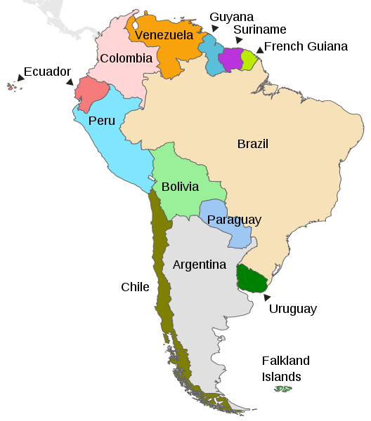
Map depicting the countries on the continent of South America.
Natural Geography of Brazil
Major Landforms
Brazil's physical features can be grouped into five main physiographic divisions, each characterized by distinct geographical and environmental characteristics. These divisions contribute to the country's diverse landscapes and ecosystems. The five physiographic divisions of Brazil are:
The Amazon Basin: Encompassing a significant portion of northern Brazil, the Amazon Basin is characterized by the vast Amazon Rainforest, the largest tropical rainforest in the world
The Pantanal: Located in the western part of Brazil, the Pantanal is the world's largest tropical wetland area
The Brazilian Highlands (or the Plateau): Covering a large portion of central and southeastern Brazil, the Brazilian Highlands consist of a vast plateau with rolling hills and escarpments
The Atlantic Coastal Plain: Stretching along Brazil's eastern coast, the Atlantic Coastal Plain is a low-lying region featuring sandy beaches, lagoons, and coastal forests.
The Guiana Highlands (or the Northern Highlands): Located in the northern part of Brazil, bordering other countries such as Venezuela and Guyana, the Guiana Highlands are characterized by ancient plateaus and tepuis (tabletop mountains)
These five physiographic divisions collectively contribute to Brazil's reputation as a country with remarkable environmental diversity. Brazil encompasses dense rainforests, expansive wetlands, high plateaus, coastal plains, and distinctive mountainous landscapes. This diversity not only influences the country's climate but also shapes the distribution of flora and fauna, making Brazil a global biodiversity hotspot.
Amazon Lowlands
The Amazon Lowlands, synonymous with the expansive Amazon Basin, constitute a vast and ecologically significant region renowned for its unparalleled biodiversity and unique geographical features. This lowland expanse sprawls predominantly across the northern part of South America and is notably characterized by its close correspondence to the Amazon River's drainage basin.
Beginning at the base of the Andes, these lowlands exhibit their greatest breadth, gradually tapering eastward. The region is marked by a distinctive geographic transition from the Andes' foothills to the Amazon Basin's vast plains. A striking feature of this landscape is the presence of annually flooded plains, known as "várzeas," which create a ribbon-like pattern as they extend eastward. These várzeas are a crucial component of the Amazon's hydrological cycle, experiencing seasonal inundation that sustains a dynamic and diverse ecosystem.
The Amazon Lowlands are pivotal in delineating the Brazilian Highlands' northern boundaries and the Guiana Highlands' southern periphery. This delineation is accentuated by the presence of undulating hills that gently rise and fall across the landscape, contributing to the overall topographical diversity of the region. While not as rugged as the Andes to the west, these hills impart a subtle relief to the Amazon Lowlands and influence the flow patterns of rivers and tributaries.
Pantanal
The Pantanal, located primarily in the western part of Brazil, is an expansive and unique landform renowned as the world's largest tropical wetland. Characterized by seasonal flooding, the Pantanal undergoes a dramatic transformation each year. During the wet season, typically from November to March, heavy rainfall and rising water levels from surrounding rivers cause the low-lying landscape to become an immense floodplain. This annual inundation is vital to the Pantanal's ecological vitality, creating a dynamic and ever-changing environment.
The Pantanal's topography consists of vast stretches of flat plains interspersed with patches of grasslands, forests, and water features. The region's low-lying terrain and seasonal flooding create a mosaic of habitats, fostering an incredible diversity of flora and fauna. The wetland supports a wealth of wildlife, including iconic species like jaguars and capybaras and an extensive array of bird species. The interplay between the wet and dry seasons defines the Pantanal's distinctive landform, making it a globally significant and visually captivating ecosystem that showcases the delicate harmony between water and land.
Brazilian Highlands
The Brazilian Highlands, also known as the Brazilian Plateau, constitute a vast and elevated landform that spans a significant portion of central and southeastern Brazil. This expansive plateau is characterized by undulating hills, rolling plains, and dissected plateaus, creating a diverse topographical landscape. Unlike the low-lying Pantanal, the Brazilian Highlands stand at higher elevations, creating a more rugged and varied terrain.
The Highlands are geographically significant, forming a natural divide between the Amazon Basin to the north and the Paraná-Paraguay River system to the south. This elevated region is home to various mountain ranges, including the Serra do Mar and Serra Geral, which run parallel to the Atlantic coast. These mountainous formations add a dramatic element to the Brazilian Highlands, creating stunning landscapes and influencing local climates.
Atlantic Coastal Lowlands
The Atlantic Coastal Lowlands, stretching along Brazil's eastern coast, form a distinct and geographically significant region characterized by low-lying plains and coastal features. This coastal lowland region extends from the northern state of Amapá to the southern state of Rio Grande do Sul, bordering the Atlantic Ocean. It encompasses diverse landscapes, including sandy beaches, lagoons, and mangrove swamps.
The topography of the Atlantic Coastal Lowlands is generally flat, creating extensive plains that gradually rise inland. This region is a natural transition between the Atlantic Ocean and the Brazilian Highlands to the west. The lowlands are often intersected by rivers that flow eastward towards the Atlantic, contributing to the formation of estuaries and creating fertile deltas.
Major cities, including Rio de Janeiro and São Paulo, are situated in the Atlantic Coastal Lowlands, highlighting the region's economic and cultural importance. Access to the coast has historically facilitated maritime trade and contributed to the development of thriving urban centers.
The Atlantic Coastal Lowlands boasts a variety of ecosystems, including coastal forests and wetlands, providing habitats for diverse flora and fauna. This region plays a crucial role in terms of biodiversity and is a key area for conservation efforts. Additionally, the scenic landscapes and coastal cities make Brazil's Atlantic Coastal Lowlands a significant cultural and economic hub.
Guiana Highlands
The Guiana Highlands, also known as the Brazilian Guiana Shield, is a vast and ancient plateau in northern Brazil, extending into Venezuela, Guyana, Suriname, and French Guiana. This elevated landform is characterized by rugged terrain, towering tabletop mountains known as tepuis, and dense tropical rainforests. The Guiana Highlands represent one of the oldest geological formations on Earth, with landscapes shaped over millions of years.
The topography of the Guiana Highlands features imposing tepuis flat-topped mountains with cliffs, creating a surreal and unique landscape. These mesas have become famous for their isolated ecosystems and have inspired various myths and legends. The region is also marked by deep river valleys, including the Orinoco and Amazon basins, which cut through the highlands, contributing to the overall diversity of the area.
The Guiana Highlands are rich in biodiversity, hosting many plant and animal species. The dense rainforests that cover the highlands are home to numerous endemic and unique organisms, making it a significant area for ecological research and conservation. While the Guiana Highlands are sparsely populated due to their challenging terrain, they hold cultural importance for indigenous communities adapting to life in this rugged environment.
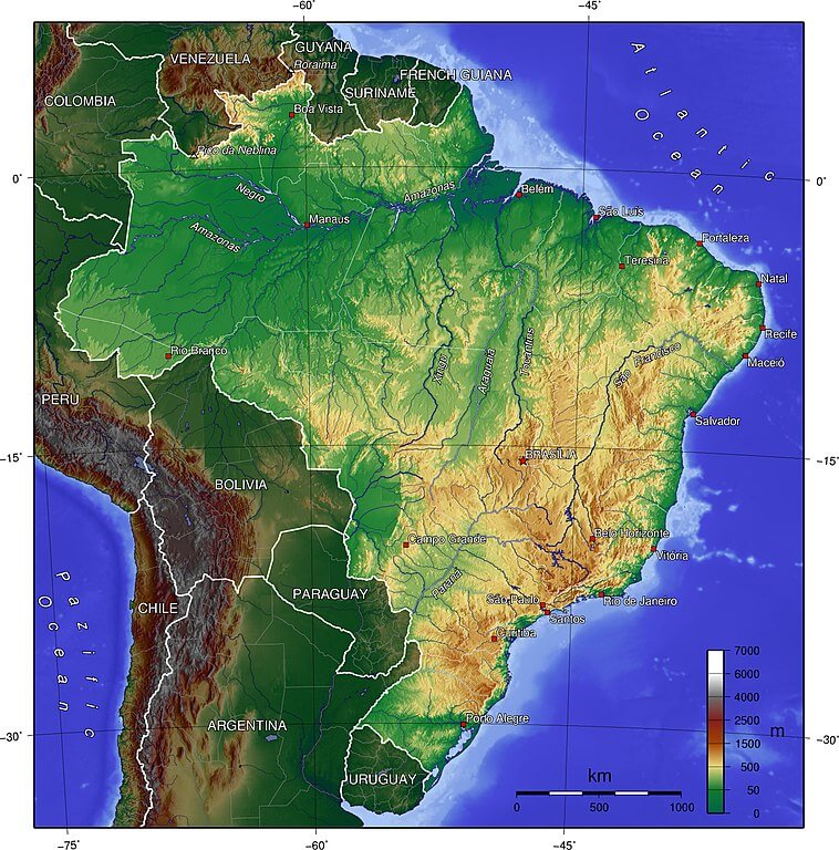
Topographical map of Brazil.
Natural Regions / Biomes
Brazil's territory comprises six terrestrial biomes and one marine biome. Biomes are natural regions distinguished by geography, climate, and associated flora and fauna. They are classified according to their predominant vegetation.
Amazon (Amazônia)
The Amazon Biome contains the Amazon Rainforest, an area of tropical rainforest and other ecoregions that cover most of the Amazon Basin, along with some adjacent areas to the north and east.
As the most extensive forest formation on the planet, spanning 6.7 million sq km (2.6 million sq mi), the Amazon Biome is virtually unrivaled in scale and complexity. It contains blackwater and whitewater flooded forests, lowland and montane forests, bamboo and palm forests, savanna, sandy heath, and alpine tundra.
This biome is considered one of the most critical areas on Earth. It represents half of the world's rainforest and is home to one-third of Earth's species. It is also an essential global storehouse of carbon. For those reasons, the Brazilian Amazon is one of the most studied biomes in the world.
Atlantic Forest (Mata Atlântica)
The Atlantic Forest (Mata Atlântica) once stretched over much of Brazil's Atlantic coastline and covered parts of Paraguay, Uruguay, and Argentina. Today, it survives mainly in small degraded patches and protected areas.
This tropical forest is found in Brazil's coastal region, and it is characterized by humid winds coming from the sea and steep reliefs. Because of its multiple altitudes, latitudes, and climates, it comprises various ecosystems, ranging from semideciduous seasonal forests to open mountain fields and Araucaria forests in the south.
Caatinga
The Caatinga is a semiarid biome and South America's largest dry forest region. It is the only biome that is exclusively Brazilian and one of the richest dry forests in the world. Consisting primarily of xeric shrubland and thorn forest, the biome covers the northeast portion of Brazil and occupies approximately 10% of the country's area.
Cerrado
The Cerrado is the largest savanna region in South America and the largest ecoregion in the Americas. Biologically, it is the richest savanna in the world. As the second-largest Brazilian biome, it encompasses approximately 22% of its land area. The Cerrado is dry and hot but far from lifeless, comprising a wide range of plant and animal biodiversity. The World Wildlife Fund describes it as the richest savanna in the world.
Over the past 35 years, more than half of the biome's original area has been converted to agriculture, dramatically changing Brazilian land use.
Pampa
The Pampa (Las Pampas) is a vast, fertile lowland plain region that represents just over 2% of Brazil's national territory. The biome lies within the South Temperate Zone and has subtropical and temperate climates with four well-characterized seasons. Grasslands, with sparse shrub and tree formations, are the dominant vegetation.
Pantanal
The Pantanal is a natural region encompassing the world's largest tropical wetland. This gigantic seasonal floodplain is also home to many plants and wildlife. Periods of inundation and desiccation alternate annually. Despite this, the area supports a rich agricultural and eco-tourism economy. It occupies just under 2% of Brazil's national territory.
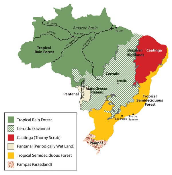
Map of Brazil's six main biomes.
Mountain Ranges
Brazil is a vast country with diverse geography, but it is primarily known for its extensive lowland areas and the Amazon Rainforest. While Brazil does not have extensive mountain ranges like the Andes in South America, it does have some notable mountainous regions.
Brazil's mountains are predominantly found in the southeastern and southern regions. These ranges include cliffs, dense rainforests, and high-altitude plateaus. The mountains contribute to the country's rich biodiversity, with many of them forming part of the Atlantic Forest, a critically important biome.
See more: Mountain Ranges of Brazil
Islands and Archipelagos
Brazil's islands and archipelagos are diverse, ranging from the remote and uninhabited Saint Peter and Saint Paul Archipelago to the popular tourist destination of Fernando de Noronha. Brazil's islands offer an array of natural wonders and cultural treasures.
See more: Islands and Archipelagos of Brazil
Bodies of Water
Brazil has many water bodies that span its vast and diverse natural landscape. The country offers a remarkable range of aquatic environments, from mighty rivers and expansive wetlands to breathtaking waterfalls and stunning coastal areas.
See more: Water Bodies of Brazil
Administrative Divisions
Brazil is comprised of 26 states and one federal district. The states are subdivided into municipalities and conventionally divided into five regions based on geographic location.
See more: Cultural Landscape of Brazil
Ecological Regions
The following is a list of terrestrial ecoregions in Brazil, as defined by the World Wide Fund for Nature (WWF). Brazil is in the neotropical realm. Ecoregions are classified by biome type—the major global plant communities determined by rainfall and climate.
Tropical and subtropical moist broadleaf forests
Atlantic Coast restingas
Bahia coastal forests
Bahia interior forests
Caatinga Enclaves moist forests
Fernando de Noronha-Atol das Rocas moist forests
Guayanan Highlands moist forests
Guianan piedmont and lowland moist forests
Japurá-Solimões-Negro moist forests
Madeira-Tapajós moist forests
Maranhão Babaçu forests
Mato Grosso tropical dry forests
Negro-Branco moist forests
Northeastern Brazil restingas
Pantepui forests and shrublands
Purus-Madeira moist forests
Solimões-Japurá moist forests
Southwest Amazon moist forests
Tapajós-Xingu moist forests
Tocantins-Araguaia-Maranhão moist forests
Trindade and Martim Vaz Islands tropical forest
Uatuma-Trombetas moist forests
Xingu-Tocantins-Araguaia moist forests
Tropical and subtropical dry broadleaf forests
Tropical and subtropical grasslands, savannas, and shrublands
Campos rupestres
Flooded grasslands and savannas
Deserts and xeric shrublands
Saint Peter and Saint Paul rocks
Mangroves
Amapá mangroves
Bahia mangroves
Ilha Grande mangroves
Pará mangroves
Rio Piranhas mangroves
Rio São Francisco mangroves
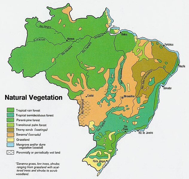
Terrestrial biomes distribution Map of Brazil.