Brazil's Surprising Mountain Landscapes: Ancient Peaks in a Land of Plateaus
Brazil's territory, often linked to the Amazon and coastal plains, contains diverse mountain ranges from the Precambrian era to recent formations. These ancient peaks and dramatic escarpments create a complex topographical mosaic across all regions of South America's largest nation.
 via Wikimedia Commons")
 via Wikimedia Commons")
 via Wikimedia Commons")

 https://www.flickr.com/photos/12193845@N00/421888073")

From Coastal Escarpments to Highland Plateaus: Brazil's Diverse Topography
Brazil's vast territory, while commonly associated with the Amazon rainforest and coastal plains, harbors a remarkably diverse collection of mountain ranges that span geological periods from the Precambrian era to relatively recent formations. These ancient peaks, dramatic escarpments, and isolated massifs form a complex topographical mosaic that spans all regions of South America's largest nation. Covering over 8.5 million square kilometers (3.3 million square miles), Brazil's mountains range from the towering Pico da Neblina along the Venezuelan border to the rolling hills of the southern highlands, encompassing some of the world's oldest geological formations alongside more recent uplifts.
The Brazilian mountain systems, although generally lower in elevation than the Andes, play crucial roles in the country's hydrology, climate patterns, and biodiversity. They serve as watersheds for major river systems, create microclimates that support unique ecosystems, and provide the geological foundation for much of Brazil's mineral wealth. From the dramatic coastal escarpments of the Serra do Mar to the ancient quartzite peaks of the Chapada Diamantina, Brazil's mountains represent a geological library that chronicles billions of years of Earth's history while supporting some of the world's most distinctive and threatened ecosystems, including the unique cerrado savannas, Atlantic Forest fragments, and specialized rock field communities that have evolved in isolation on these ancient summits.
The Coastal Mountain Systems
Serra do Mar (Sea Range)
The Serra do Mar represents Brazil's most prominent and continuous mountain system, forming a dramatic escarpment that runs parallel to the Atlantic coast for over 1,500 kilometers (932 miles) from Rio de Janeiro to Santa Catarina. This ancient range, with elevations reaching up to 2,245 meters (7,365 feet) at Pico da Caledônia, creates one of the world's steepest coastal mountain faces, rising abruptly from sea level to over 1,000 meters (3,281 feet) within just a few kilometers of the shoreline.
Geological Significance: The Serra do Mar is primarily composed of Precambrian crystalline rocks, including granites, gneisses, and schists, which formed over 500 million years ago. The range's steep Atlantic-facing slopes support remnants of the Atlantic Forest (Mata Atlântica), one of the world's most endangered biomes and a UNESCO World Heritage Site.
Subranges and Local Names
- Serra dos Órgãos: Famous for its distinctive rock formations near Rio de Janeiro
- Serra da Mantiqueira: Northern extension reaching into Minas Gerais
- Serra da Bocaina: Connecting link between Rio de Janeiro and São Paulo states
- Serra de Paranapiacaba: Southern portion extending into São Paulo
Serra da Mantiqueira
The Serra da Mantiqueira forms a northeastern extension of the coastal mountain system, creating a natural barrier between the states of Rio de Janeiro, São Paulo, and Minas Gerais. This range contains some of southeastern Brazil's highest peaks and most essential watersheds, serving as the source for numerous tributaries of the Paraná River system.
The Central Highlands and Plateau Systems
Planalto Central (Central Plateau)
The Central Plateau represents the elevated core of Brazil, encompassing much of the states of Goiás, Minas Gerais, and the Federal District. While not featuring dramatic individual peaks, this vast elevated region sits at elevations between 800 and 1,200 meters (2,625 and 3,937 feet) and contains numerous isolated mountain ranges and mesa formations.
Serra da Canastra: This range in western Minas Gerais reaches elevations of 1,496 meters (4,908 feet) and contains the source of the São Francisco River, one of Brazil's most important waterways. The area is famous for its quartzite formations and endemic plant species.
Serra do Cipó: Located in central Minas Gerais, this range features unique rock formations and serves as a crucial watershed for the São Francisco River basin. The area is renowned for its endemic flora and distinctive quartzite landscapes.
Chapada dos Veadeiros
This elevated plateau in Goiás state reaches elevations up to 1,676 meters (5,499 feet) and represents one of the world's oldest geological formations, with rocks dating back nearly 2 billion years. The area is characterized by vast savannas, gallery forests, and unique rock formations that support highly endemic plant and animal communities.
The Amazon Mountain Systems
Pacaraima Mountains (Serra Pacaraima)
The Pacaraima Mountains form part of the Guiana Highlands along Brazil's northern border with Venezuela and Guyana. This ancient mountain system, with rocks dating back over 2 billion years, reaches its highest point in Brazil at Monte Roraima, which stands at 2,734 meters (8,970 feet) above sea level. The range is characterized by distinctive table mountains (tepuis) that rise dramatically from surrounding lowlands, creating isolated biological islands that support extraordinary levels of endemism.
Monte Roraima: Situated on the border between Brazil, Venezuela, and Guyana, Monte Roraima is one of South America's most iconic geological formations. This massive tepui, with its flat summit covering approximately 31 square kilometers (12 square miles), inspired Arthur Conan Doyle's novel "The Lost World" and continues to fascinate scientists and adventurers with its unique ecosystems and endemic species.
Tepui Ecosystems: The Pacaraima Mountains' tepuis support specialized plant and animal communities that have evolved in isolation for millions of years. These table mountains feature unique geological formations, endemic species, and distinctive ecosystems that differ markedly from surrounding lowland environments.
Serra da Neblina (Mist Range)
Located along Brazil's border with Venezuela, the Serra da Neblina contains Brazil's highest peak, Pico da Neblina, at 2,994 meters (9,823 feet). This remote mountain system, shrouded in perpetual mist and clouds, supports unique tepui-like ecosystems similar to those found in Venezuela's Guiana Highlands.
Endemic Ecosystems: The isolated nature of these mountains has led to extraordinary levels of endemism, with numerous plant and animal species found nowhere else on Earth. The constant moisture from orographic precipitation creates specialized cloud forest ecosystems.
Serra dos Carajás
This iron-rich mountain system in Pará state, while modest in elevation at around 800 meters (2,625 feet), contains some of the world's largest iron ore deposits. The unique geological composition has created specialized plant communities adapted to iron-rich soils.
The Northeastern Highlands
Chapada Diamantina
Located in central Bahia, the Chapada Diamantina represents one of Brazil's most spectacular mountain landscapes, featuring dramatic table mountains, deep canyons, and extensive cave systems. The highest point, Pico do Barbado, reaches 2,033 meters (6,670 feet), making it one of northeastern Brazil's tallest peaks.
Geological Features: The region is characterized by Precambrian sedimentary rocks, primarily sandstones and quartzites, that have been sculpted by millions of years of erosion into spectacular mesas, buttes, and canyons. The area contains extensive cave systems, including some of Brazil's deepest caverns.
Unique Ecosystems: The Chapada Diamantina supports a mosaic of ecosystems, including cerrado savannas, caatinga dry forests, and specialized rock field communities. Many plant species are endemic to the region's unique soil and climate conditions.
Serra da Ibiapaba
The Serra da Ibiapaba forms an important escarpment along the border between Ceará and Piauí states in northeastern Brazil. This sedimentary plateau rises to elevations of approximately 900 meters (2,953 feet), creating a dramatic transition between the coastal lowlands and the interior highlands. The range's eastern face forms a steep escarpment that captures moisture from Atlantic trade winds, creating a relatively humid microclimate that supports unique forest enclaves within the otherwise semi-arid caatinga region.
Ecological Significance: The Serra da Ibiapaba serves as a crucial refuge for Atlantic Forest species in northeastern Brazil, supporting remnant forest patches that harbor species otherwise found hundreds of kilometers to the south. The range's unique position creates important habitat corridors and serves as a stepping stone for species distribution between different biogeographical regions.
Serra da Capivara
This archaeological and geological treasure in Piauí state features ancient rock formations and contains one of the world's most important collections of prehistoric rock art. The mountains rise to about 600 meters (1,969 feet) and preserve evidence of human occupation dating back over 25,000 years.
The Southern Highlands
Serra Geral
The Serra Geral extends across southern Brazil, forming the eastern edge of the Paraná Basin and creating dramatic canyons and escarpments. This range, which reaches elevations of up to 1,398 meters (4,587 feet), is renowned for its basaltic formations and spectacular canyon systems.
Aparados da Serra: This section of the Serra Geral features some of South America's most impressive canyons, including Itaimbezinho Canyon, which reaches depths of over 700 meters (2,297 feet). The area represents a transition zone between subtropical and temperate ecosystems.
Serra do Rio do Rastro
Located in Santa Catarina, this range is famous for its winding mountain roads and reaches elevations of 1,460 meters (4,790 feet). The area supports unique high-altitude grasslands and cloud forests.
Unique Geological Features
Tepuis and Table Mountains
Brazil's northern regions feature tepui-like formations, isolated table mountains that rise abruptly from surrounding lowlands. These ancient formations, particularly in the Serra da Neblina and along the Venezuelan border, support unique ecosystems that have evolved in isolation for millions of years.
Quartzite Landscapes
Many of Brazil's mountain ranges, particularly in Minas Gerais and Bahia, are characterized by quartzite formations that create distinctive white and pink rock landscapes. These areas often support specialized plant communities adapted to the nutrient-poor, well-drained soils typical of quartzite substrates.
Cave Systems
Brazil's mountains are home to extensive cave systems, particularly in limestone and quartzite formations. The Chapada Diamantina alone contains over 2,000 known caves, including some of Brazil's deepest and most extensive underground systems.
Ecological Significance and Biodiversity
Biogeographical Islands
Many of Brazil's isolated mountain ranges function as "sky islands," supporting species that became isolated as the climate changed over geological time. These mountains often harbor relict populations of plants and animals that once had wider distributions during different climatic periods.
Endemic Species Centers
Several mountain ranges serve as centers of endemism, particularly for plant species. The Serra do Cipó, Chapada Diamantina, and Serra da Canastra each support numerous endemic species found nowhere else on Earth.
Watershed Functions
Brazil's mountains serve as crucial watersheds for the country's major river systems, including the São Francisco, Paraná, and Amazon rivers. The elevated terrain captures moisture from Atlantic weather systems and channels it into the continent's major drainage basins.
Cultural and Historical Significance
Mining Heritage
Many of Brazil's mountain ranges played crucial roles in the country's colonial history, particularly during the gold and diamond rushes of the 18th century. The Chapada Diamantina, Serra da Canastra, and various ranges in Minas Gerais are home to numerous historical mining sites and colonial-era towns.
Indigenous Heritage
Brazil's mountains have been home to numerous indigenous peoples for thousands of years, with many groups maintaining traditional relationships with specific mountain landscapes. The Serra da Capivara contains some of the Americas' most important archaeological sites, preserving evidence of ancient human cultures.
Economic Importance
Mineral Resources
Brazil's mountains contain significant mineral wealth, including iron ore (Serra dos Carajás), gold, diamonds, and a variety of other minerals. The country's position as a major global mining producer is largely due to the geological processes that concentrated minerals in its mountain regions.
Water Resources
Mountain watersheds provide water for Brazil's major cities and agricultural regions. The São Francisco River, originating in the Serra da Canastra, serves as a crucial water source for northeastern Brazil, while coastal mountains supply water for major urban centers like Rio de Janeiro and São Paulo.
Tourism and Recreation
Brazil's mountains attract millions of visitors annually, from eco-tourists exploring the Chapada Diamantina to mountaineers climbing in the Serra dos Órgãos. The combination of spectacular scenery, unique ecosystems, and cultural heritage makes these areas increasingly important for Brazil's tourism industry.
Conservation Challenges and Efforts
Protected Areas
Brazil has established numerous protected areas within its mountain regions, including Chapada Diamantina National Park, Serra dos Órgãos National Park, and Itatiaia National Park. These areas preserve critical ecosystems while supporting research and sustainable tourism.
Threats and Pressures
Brazil's mountain ecosystems face numerous threats, including agricultural expansion, mining activities, urban development, and the introduction of invasive species. Climate change poses additional challenges, particularly for high-altitude ecosystems and endemic species with limited distribution ranges.
Conclusion
Brazil's mountain ranges, while often overshadowed by the country's more famous Amazon rainforest and coastal attractions, represent some of South America's most ancient and ecologically significant highland systems. From the towering Pico da Neblina in the remote Amazon borderlands to the dramatic escarpments of the Serra do Mar, these mountains embody billions of years of geological history while supporting extraordinary biodiversity and unique ecosystems. Brazil's mountains serve as the country's water towers, mineral treasures, and biological laboratories, providing essential ecosystem services while harboring countless endemic species found nowhere else on Earth.
As Brazil continues to develop as a major global economic power, the conservation and sustainable management of these mountain environments becomes increasingly critical for maintaining the country's natural heritage and ecological integrity. The ancient peaks that have witnessed the rise and fall of countless species and civilizations continue to shape Brazil's environmental destiny, serving as enduring monuments to the planet's geological history and the remarkable diversity of life that these vertical landscapes can support. In protecting these magnificent ranges, Brazil not only preserves its natural heritage but also safeguards irreplaceable components of global biodiversity and geological heritage that represent millions of years of evolutionary history.
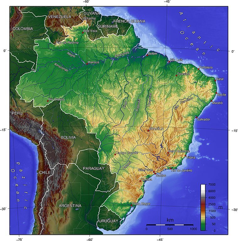
Topographical map of Brazil.
Major Peaks of Brazil
Brazil's Highest Summits
Amazon Region:
- Pico da Neblina: 2,994 m (9,823 ft) - Brazil's highest peak
- Pico 31 de Março: 2,972 m (9,751 ft)
- Monte Roraima: 2,734 m (8,970 ft) - Pacaraima Mountains
- Pico da Bandeira (Roraima): 2,875 m (9,432 ft)
Southeastern Highlands:
- Pico da Bandeira (Espírito Santo/Minas Gerais): 2,892 m (9,488 ft)
- Pedra da Mina: 2,798 m (9,180 ft)
- Pico das Agulhas Negras: 2,791 m (9,157 ft)
- Pico do Cristal: 2,769 m (9,085 ft)
- Morro do Couto: 2,680 m (8,793 ft)
- Pico do Sol: 2,072 m (6,798 ft) - Serra do Espinhaço
Coastal Ranges:
- Pico da Caledônia: 2,245 m (7,365 ft) - Serra do Mar
- Pedra do Sino: 2,263 m (7,425 ft) - Serra dos Órgãos
- Pico das Prateleiras: 2,540 m (8,333 ft)
Central Highlands:
- Pico da Canastra: 1,496 m (4,908 ft)
- Alto do Palácio: 1,676 m (5,499 ft) - Chapada dos Veadeiros
Northeastern Highlands:
- Pico do Barbado: 2,033 m (6,670 ft) - Chapada Diamantina
- Pico do Itobira: 1,970 m (6,463 ft)
Southern Highlands:
- Morro da Igreja: 1,822 m (5,978 ft)
- Morro Pelado: 1,398 m (4,587 ft)