Nicaragua: Natural Landscape
Nicaragua is situated in Central America between Honduras in the north and Costa Rica in the south. Its geography divides the country into three major zones: the Pacific lowlands, the north-central highlands, and the Caribbean lowlands or Mosquito Coast.

 https://www.flickr.com/photos/nataskola/2960112329/")
 https://www.flickr.com/photos/a-barth/66637333")

 https://www.flickr.com/photos/ciat/5471243937")

 https://www.flickr.com/photos/lonqueta/3853904902")

 https://www.flickr.com/photos/adamcohn/9719423817")
 https://www.flickr.com/photos/lonqueta/3843080819")
 https://www.flickr.com/photos/eu_echo/9474711966")
The Natural Landscape of Nicaragua
Nicaragua, the largest country in Central America in terms of land area, is strategically positioned between Honduras to the north and Costa Rica to the south. Bordered by the Caribbean Sea to the east and the Pacific Ocean to the southwest, Nicaragua boasts a diverse geographical landscape with numerous islands off its Pacific and Caribbean coasts.
Among the noteworthy islands of Nicaragua are the picturesque Corn Islands, positioned 80 to 95 kilometers (50 to 59 miles) off the Caribbean coast. The Miskito Cays, the Pearl Cays, the Nancital Archipelago, Juan Venado Island, and others contribute to Nicaragua's rich maritime geography.
The country is home to two of Central America's largest lakes: Lake Nicaragua and Lake Managua. Lake Nicaragua, ranked as the second-largest lake in Latin America after Lake Titicaca, adds to Nicaragua's prominence as a country with significant freshwater resources.
Situated within the Central America Volcanic Arc, Nicaragua boasts a remarkable natural spectacle with a chain of 19 active volcanoes forming a northwest-to-southeast alignment along its western coast. This volcanic presence not only shapes the country's topography but also contributes to its unique geological and ecological characteristics.
Biodiversity
Nicaragua, nestled in the heart of Central America, stands out for its remarkable biodiversity, fostered by various ecosystems ranging from lush rainforests to volcanic terrains, expansive lakes, and diverse coastal areas. This geographical diversity creates a haven for many plant and animal species, making Nicaragua a significant player on the global biodiversity stage.
The Global Biodiversity Index recognizes Nicaragua as the 41st most biodiverse country worldwide. This distinction is supported by impressive statistics, including 685 bird species, 75 amphibian species, 1,076 fish species, 200 mammal species, 197 reptile species, and an astounding 5,796 species of vascular plants.
Conservation
In alignment with its commitment to environmental stewardship, Nicaragua actively engages in conservation initiatives to safeguard its diverse ecosystems, protect endangered species, and advocate for sustainable land and resource management practices. Despite these efforts, the country grapples with challenges such as deforestation resulting from agricultural expansion and land use changes, habitat loss, pollution, and the impacts of climate change.
The delicate balance between conservation and the demands of a growing population and economic development presents an ongoing challenge. However, Nicaragua's dedication to preserving its natural heritage is evidenced by the implementation of comprehensive conservation programs and the establishment of protected areas. These endeavors contribute to the well-being of Nicaragua's unique ecosystems and broader global initiatives to conserve biodiversity.
Climate
Nicaragua experiences a tropical climate marked by two distinct seasons, each contributing to the country's unique environmental makeup. The wet season, stretching from May to October, immerses Nicaragua in heavy rainfall, particularly during afternoons and evenings. Following this, the dry season takes its turn from November to April, offering a respite from the rains with reduced precipitation and lower humidity. Remarkably, intermittent rainfall persists even during the dry season, emphasizing Nicaragua's climatic nuances.
Temperature variations add to the climatic diversity, with average temperatures fluctuating between 21 - 27 ˚C (70 - 80 ˚F) throughout the year. Altitude plays a role in these temperature dynamics, influencing local climates. Coastal regions tend to be warmer and more humid, creating a balmy atmosphere, while the northern mountainous areas exhibit cooler temperatures and lower humidity levels.
Volcanism
Nicaragua, situated within the Pacific Ring of Fire, boasts a notable and dynamic volcanic landscape characterized by active and dormant volcanoes. Among the active ones, Momotombo, Masaya, Telica, and Concepción stand out, exhibiting recent eruptions and ongoing signs of activity.
While inactive, dormant volcanoes retain the potential for future eruptions, adding an element of geological unpredictability to Nicaragua's terrain. The coexistence of active and dormant volcanic structures poses potential hazards, including ashfall, lava flows, pyroclastic flows, and lahars—phenomena that necessitate continuous monitoring. To mitigate risks and protect nearby populations, Nicaragua has implemented robust monitoring systems designed to assess volcanic activity promptly. Early warning mechanisms are crucial in providing timely alerts and enabling proactive measures to ensure the safety of local communities.
Interestingly, Nicaragua's volcanic activity has been harnessed for sustainable energy solutions. Geothermal power plants, strategically positioned in areas with volcanic geothermal reservoirs, tap into the Earth's natural heat to generate electricity. This dual role of volcanoes as natural wonders and potential renewable energy sources highlights the complex interplay between geological forces and human innovation in Nicaragua.
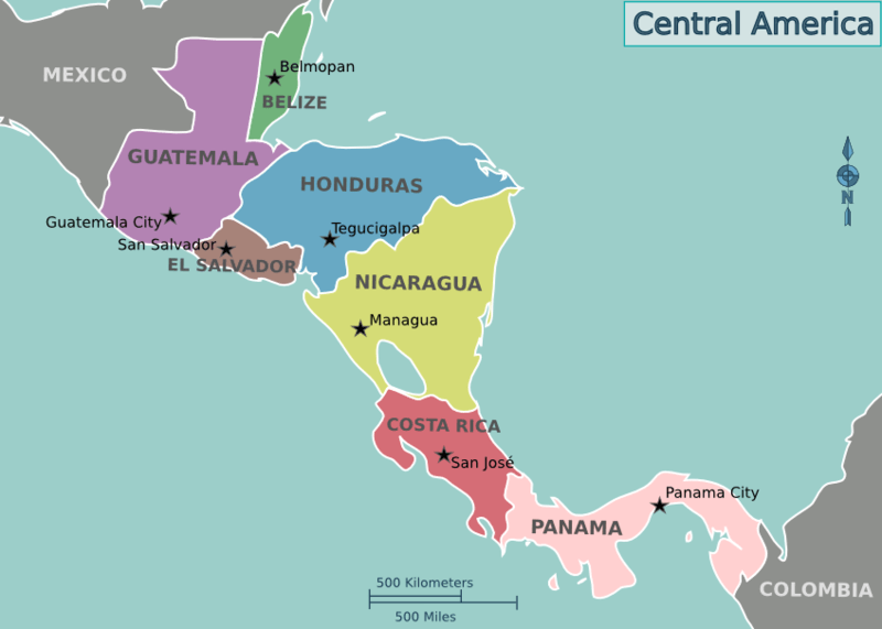
Location map of the countries of Central America.
Natural Geography of Nicaragua
Geographic Regions
Nicaragua's diverse physical geography delineates the nation into three primary zones, each offering distinct landscapes and characteristics:
- Pacific Lowlands: Nicaragua's western region is dominated by the expansive Pacific lowlands. This area, stretching along the Pacific Ocean, features a combination of coastal plains, mesas, and valleys. Characterized by its proximity to the Pacific, this zone exhibits a varied topography and plays a significant role in the country's economic activities.
- North-Central Highlands: Occupying the central expanse of Nicaragua, the north-central highlands showcase rugged and elevated terrain. This region is marked by the Sierra Madre mountain range, which contributes to its undulating landscape. The higher altitudes in the north-central highlands influence climatic conditions and support diverse ecosystems, making them a distinctive and vital part of the country's physical makeup.
- Caribbean Lowlands: To the east, the Caribbean lowlands extend along the Caribbean Sea. Lush tropical rainforests, river deltas, and a network of waterways characterize this zone. The Caribbean lowlands contribute to Nicaragua's rich biodiversity and are home to various indigenous communities. Compared to the Pacific lowlands, the contrasting features of this region provide a unique ecological and cultural mosaic within the country.
These three major geographic zones collectively define Nicaragua's physical diversity and influence climate, ecology, and human activities nationwide.
Pacific Lowlands
Stretching approximately 75 km (46 mi) inland from the Pacific coast, the Pacific lowlands in western Nicaragua constitute a vital and densely populated region known for its agricultural significance. The soil composition along the Pacific coast is primarily volcanic, contributing to the fertility of the land. The natural vegetation of the lowlands, characterized by dry forests, has undergone substantial transformation due to extensive agricultural and pastoral activities. Approximately 80% of the area boasts fertile soil, extensively cultivated for agriculture.
While much of the terrain is flat, a notable topographical feature includes a line of volcanoes between the Gulf of Fonseca, Lake Managua, and Lake Nicaragua. Lake Nicaragua stands out as a distinctive geographic element, crisscrossed by volcanoes that have given rise to numerous islands, with Ometepe Island being the largest among them.
The geographical positioning of western Nicaragua, at the convergence point of the Caribbean Plate and the Cocos Plate, exposes the region to seismic and volcanic events. Consequently, earthquakes and volcanic activity are recurrent, with numerous tremors and quakes occurring annually. Some of these events resulted in severe damage, exemplified by the near-destruction of the capital city, Managua, in 1931 and 1972. The ongoing geological dynamics underscore the challenges and resilience of the communities in this agriculturally vital yet geologically active part of the country.
The Pacific lowlands undergo distinct seasonal changes, with a rainy season from May to November, marked by lush landscapes and increased agricultural activity, and a dry season from December to April, facilitating harvesting and cultivation. Maintaining a warm annual average temperature of around 27 °C (80 °F) and receiving an average precipitation of 1,900 mm (75 in), this region sustains a delicate balance crucial for agriculture and its diverse ecosystems.
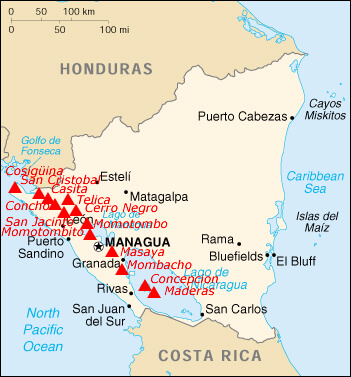
Map depicting the volcanos of Nicaragua.
North-Central Highlands
To the north and east of the Pacific lowlands lies the North-Central Highlands, characterized by a triangular expanse of rugged mountain ridges ranging from approximately 900 to 1800 m (3,000 to 6,000 ft) in elevation, interspersed with deep valleys. While the western slopes exhibit a relatively dry climate, the eastern slopes are adorned with lush rainforests.
Serving as the country's primary watershed, the central mountains predominantly channel their waters eastward to the Caribbean Sea. However, several rivers discharge westward into the Pacific Ocean or Lakes Managua and Nicaragua.
In the northern highlands, temperatures are cooler compared to the lowlands, averaging around 18 °C (64 °F). Prevailing winds from the northeast manifest as cool breezes on the elevated plateau and transform into warm, humid currents as they traverse the lowlands.
Caribbean Lowlands
Stretching across more than half of the country, the eastern Caribbean lowland plains, also recognized as the Mosquito Coast or Miskito Coast, boast a width averaging 100 km (60 mi), making them among the broadest in Central America. This extensive lowland region gracefully aligns with the Caribbean Sea, stretching approximately 360 km (225 mi).
The coastline is characterized by river mouths, deltas, and coastal lagoons, punctuated by coral reefs, islands, cays, and banks along the country's expansive continental shelf—the widest in Central America. Soils on the Caribbean coast exhibit variation, with fertile areas nestled along waterways and relatively infertile zones within the pine-savanna and rainforest regions.
The climate in the east is moderately cooler and significantly wetter than its western counterpart. During the prolonged rainy season, which lasts approximately nine months, the dry season unfolds from March through May. Annual precipitation averages around 3,800 mm (150 in) in this lush and vibrant region.
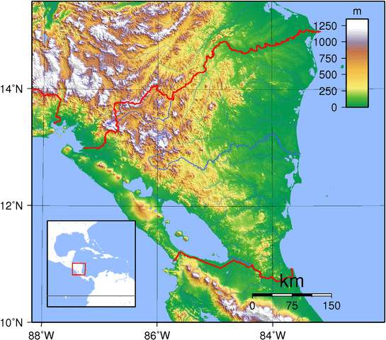
Topographic map of Nicaragua
Islands and Archipelagos
Nicaragua has several islands and archipelagos scattered across its Caribbean and Pacific coastlines. The country has a long coastline and diverse geography and is home to various islands. Each offers a unique blend of natural beauty, cultural heritage, and recreational opportunities.
See more: Islands and Archipelagos of Nicaragua
Bodies of Water
Nicaragua hosts an impressive array of water bodies, contributing to its natural beauty and ecological significance. From vast lakes to meandering rivers and serene lagoons, Nicaragua's waterways play a vital role in shaping its landscape, supporting diverse ecosystems, and providing valuable resources to its people.
See more: Water Bodies of Nicaragua
Administrative Divisions
Nicaragua is divided into 15 departments and two (self-governing) autonomous regions for administrative purposes.
See more: Cultural Landscape of Nicaragua
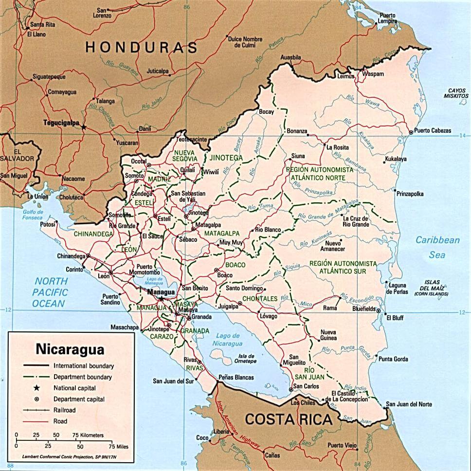
Political map of Nicaragua.
Natural Regions
The country's diverse landscapes, ranging from dense rainforests and volcanic regions to expansive lakes and coastal areas, contribute to the extraordinary wealth of flora and fauna that call Nicaragua home. The lush rainforests are a haven for an astonishing variety of plant life, including vibrant orchids, towering hardwood trees, and numerous species of medicinal plants. This, in turn, provides a thriving environment for an abundance of wildlife, from elusive jaguars and playful monkeys to a myriad of colorful birds and amphibians.
In the volcanic regions, unique microhabitats emerge, fostering the adaptation of distinct plant species. Volcanic soils often support specialized flora, and the surrounding areas become vital corridors for diverse animal populations. The coastal areas, with their mangroves, sandy shores, and coral reefs, add another layer of diversity. These ecosystems provide essential breeding grounds for marine life, including various fish species and aquatic invertebrates.
Ecological Regions
The following is a list of terrestrial ecoregions in Nicaragua, as defined by the World Wide Fund for Nature (WWF). Nicaragua is in the neotropical realm. Ecoregions are classified by biome type—the major global plant communities determined by rainfall and climate.
Tropical and subtropical moist broadleaf forest
Cayos Miskitos-San Andrés and Providencia moist forests
Central American Atlantic moist forests
Central American montane forest
Costa Rican seasonal moist forests
Isthmian-Atlantic moist forest
Tropical and subtropical dry broadleaf forests
Tropical and subtropical coniferous forests
Central American pine–oak forests
Miskito pine forests
Mangroves
Gulf of Fonseca mangroves
Mosquitia–Nicaraguan Caribbean Coast mangroves
Southern Dry Pacific Coast mangroves
Rio Negro–Rio San Sun mangroves
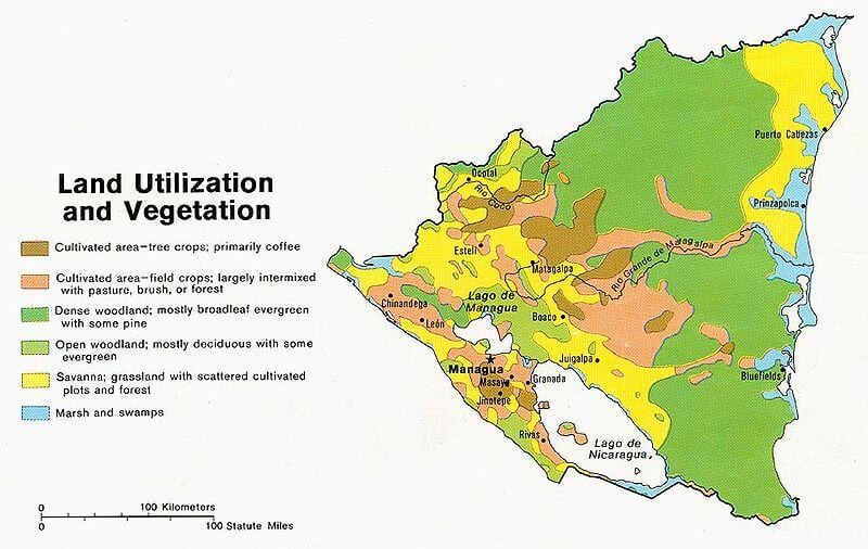
Nicaragua land use and vegetation map.